Millside Wood

Wood, Forest in Roxburghshire

Scotland

Millside Wood

Crailinghall to Cessford Road
Crailinghall to Cessford Road Credit: Richard Webb

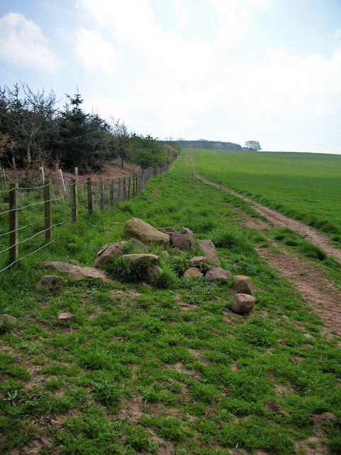
Millside Wood is a picturesque forest located in Roxburghshire, a historic county in the Scottish Borders region of Scotland. Covering an area of approximately 30 hectares, the wood is known for its diverse range of flora and fauna, making it a popular destination for nature lovers and outdoor enthusiasts.

The woodland is primarily composed of native broadleaf trees, including oak, ash, and birch, which create a vibrant and colorful canopy during the autumn months. These trees provide a habitat for a variety of wildlife, including red squirrels, roe deer, and a wide array of bird species. Birdwatchers can spot woodpeckers, owls, and various songbirds while exploring the wood.

There are several walking trails that wind through the wood, allowing visitors to fully immerse themselves in the natural beauty of the area. These trails vary in length and difficulty, catering to both casual strollers and more seasoned hikers. Along the way, visitors can enjoy breathtaking views of the surrounding countryside and may even come across the remains of an old mill, which gives the wood its name.

Millside Wood is also home to a rich assortment of wildflowers and plants, making it a haven for botany enthusiasts. Bluebells, primroses, and wild garlic can be found carpeting the forest floor in the spring, creating a stunning display of color and fragrance.

Overall, Millside Wood offers a tranquil and serene escape from the hustle and bustle of everyday life. Whether it's a leisurely walk, birdwatching, or simply enjoying the natural surroundings, this forest provides a delightful experience for visitors of all ages.

If you have any feedback on the listing, please let us know in the comments section below.

Millside Wood Images

Images are sourced within 2km of 55.493135/-2.4895489 or Grid Reference NT6922. Thanks to Geograph Open Source API. All images are credited.

Crailinghall to Cessford Road
Fields, Crailinghall The background field was being harvested.
Fields, Crailinghall
The background field was being harvested.
Field access track Through a stripwood near Crailinghall.
Field access track
Through a stripwood near Crailinghall.
Minor road near Baittens This ection of road also forms part of the route of St Cuthbert's Way, as indicated by the fingerpost on the far side of the road.
Minor road near Baittens
This ection of road also forms part of the route of St Cuthbert's Way, as indicated by the fingerpost on the far side of the road.
Across the fields to Crailing A view towards Crailing in pleasant early June conditions.
Across the fields to Crailing
A view towards Crailing in pleasant early June conditions.
Dere Street - former Roman Road - beside Stubcross Plantation Looking north-westward. Walkers, horseriders and farmers continue to make use of this ancient route.
For more detail see : <span class="nowrap"><a title="https://en.wikipedia.org/wiki/Dere_Street#Roman_route" rel="nofollow ugc noopener" href="https://en.wikipedia.org/wiki/Dere_Street#Roman_route">Link</a><img style="margin-left:2px;" alt="External link" title="External link - shift click to open in new window" src="https://s1.geograph.org.uk/img/external.png" width="10" height="10"/></span>
Dere Street - former Roman Road - beside Stubcross Plantation
Looking north-westward. Walkers, horseriders and farmers continue to make use of this ancient route. For more detail see : LinkExternal link
Grazing land hosting sheep and hay bales Looking south-westward.
Grazing land hosting sheep and hay bales
Looking south-westward.
Hedge-lined minor road at Baittens Looking north-eastward.
Hedge-lined minor road at Baittens
Looking north-eastward.
Cattle and Hay sheds at Crailinghall Farm
Hexagonal shaped folly near Crailinghall
Barn at Brownrigg - on the St.Cuthbert's Way long distance footpath
A short tarmac section of St.Cuthbert's Way long distance footpath The long distance footpath comes towards the photographer. This is the Crailing road. The ldf then exits to the right of picture and returns to tracks at Brownrigg 100m away.
A short tarmac section of St.Cuthbert's Way long distance footpath
The long distance footpath comes towards the photographer. This is the Crailing road. The ldf then exits to the right of picture and returns to tracks at Brownrigg 100m away.
Hillhead Plantation from Dere Street Along the old Roman Road from York to Trimontium (near Melrose)
Hillhead Plantation from Dere Street
Along the old Roman Road from York to Trimontium (near Melrose)
Woodland at Tod's Dean
Cragsheilhill Wood Southern edge of the wood, looking south-east.
Cragsheilhill Wood
Southern edge of the wood, looking south-east.
Unclassified road near Brownrigg
Brownrigg A new house under construction at Brownrigg.  The men working on the roof were contending with one of the hottest days of the year.
Brownrigg
A new house under construction at Brownrigg. The men working on the roof were contending with one of the hottest days of the year.
The upper reaches of Wooden Glen Seen from the St Cuthbert's Way long distance footpath.
The upper reaches of Wooden Glen
Seen from the St Cuthbert's Way long distance footpath.
Show me another place!

Millside Wood is located at Grid Ref: NT6922 (Lat: 55.493135, Lng: -2.4895489)

Unitary Authority: The Scottish Borders

Police Authority: The Lothians and Scottish Borders

What 3 Words

///cools.binders.retail. Near Jedburgh, Scottish Borders

Related Wikis

Crailinghall

Crailinghall is a village near Oxnam in the Scottish Borders area of Scotland, in the former Roxburghshire. Crailinghall is on the route of the St. Cuthbert...

Crailing

Crailing is a village on the A698, in Teviotdale, 4m east of Jedburgh in the Scottish Borders area of Scotland, in the historic county of Roxburghshire...

Roxburghshire

Roxburghshire or the County of Roxburgh (Scottish Gaelic: Siorrachd Rosbroig) is a historic county and registration county in the Southern Uplands of Scotland...

Roxburgh, Ettrick and Lauderdale

Roxburgh, Ettrick and Lauderdale (Rosbrog, Eadaraig agus Srath Labhdair in Scottish Gaelic) is a lieutenancy area of Scotland. The lieutenancy area was...

Nearby Amenities

Located within 500m of 55.493135,-2.4895489
Passing Place
Lat/Long: 55.4889589/-2.4910199
Natural: peak
Lat/Long: 55.4908775/-2.4904219
Trumpeters Knowe
Natural: peak
Lat/Long: 55.4964786/-2.4882229
Natural: peak
Lat/Long: 55.4930292/-2.4896469
Passing Place
Lat/Long: 55.4891768/-2.4871885
The data included in this document is from www.openstreetmap.org. The data is made available under ODbL.

Have you been to Millside Wood?

Leave your review of Millside Wood below (or comments, questions and feedback).