Kitty Plantation

Wood, Forest in Roxburghshire

Scotland

Kitty Plantation

Field and embankment near Whitslaid With an Ash tree that so far has avoided the dieback.
Field and embankment near Whitslaid Credit: M J Richardson

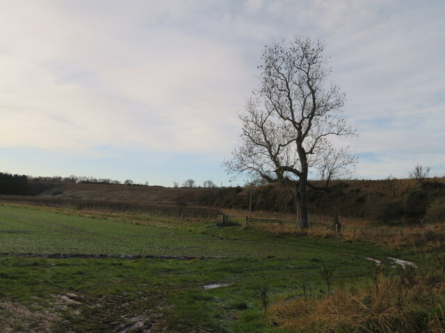
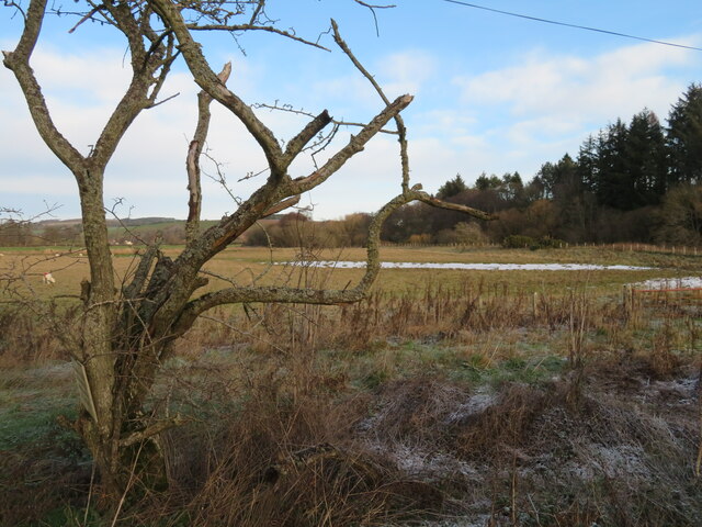
Kitty Plantation is a picturesque forest located in Roxburghshire, Scotland. Covering an area of approximately 500 acres, the plantation is known for its diverse range of tree species, including oak, beech, and pine. The forest is a popular destination for hikers, nature enthusiasts, and birdwatchers, offering a tranquil and scenic environment for outdoor activities.

Kitty Plantation is home to a variety of wildlife, including deer, foxes, and various bird species. The forest is carefully managed to ensure the preservation of its natural beauty and ecological diversity. Visitors can explore the numerous walking trails that wind through the forest, providing opportunities to observe the flora and fauna that call Kitty Plantation home.

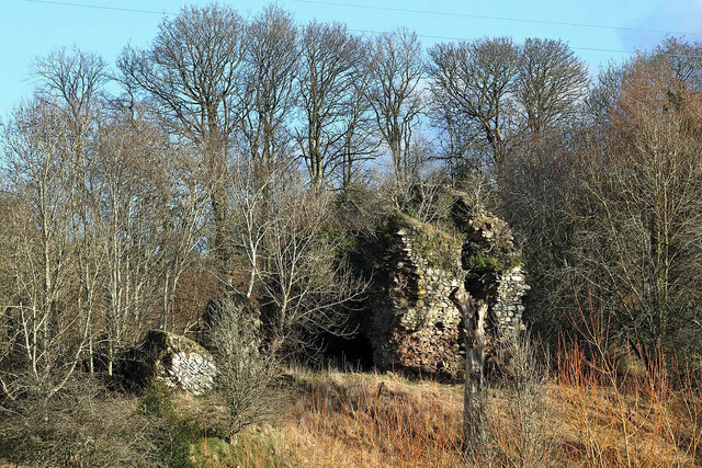
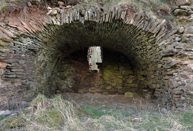
In addition to its natural beauty, Kitty Plantation also has historical significance, with remnants of old structures and ruins scattered throughout the forest. These remnants offer a glimpse into the area's past and add to the charm and intrigue of the forest.

Overall, Kitty Plantation is a tranquil and enchanting destination that offers visitors a chance to connect with nature and immerse themselves in the beauty of the Scottish countryside.

If you have any feedback on the listing, please let us know in the comments section below.

Kitty Plantation Images

Images are sourced within 2km of 55.683092/-2.7123478 or Grid Reference NT5543. Thanks to Geograph Open Source API. All images are credited.

Field and embankment near Whitslaid With an Ash tree that so far has avoided the dieback.
Field and embankment near Whitslaid
With an Ash tree that so far has avoided the dieback.
Sheep pasture in Lauderdale With a contorted Hawthorn. The Leader Water is running alongside the trees on the right. The remains of the first snow of the year, which fell the day before, are in the depression.
Sheep pasture in Lauderdale
With a contorted Hawthorn. The Leader Water is running alongside the trees on the right. The remains of the first snow of the year, which fell the day before, are in the depression.
Upper Blainslie Trig Point Flush Bracket S7408
Road near Nether Blainslie - slippier than it looks
New house at Springfield Adjacent to Fordswell farm.
New house at Springfield
Adjacent to Fordswell farm.
Upper Blainslie Cottages And grass field, with dry-stone wall.
Upper Blainslie Cottages
And grass field, with dry-stone wall.
The Stell at Upper Blainslie A house by the farm cottages. Seen across a grass field and dry-stone wall.
The Stell at Upper Blainslie
A house by the farm cottages. Seen across a grass field and dry-stone wall.
Field track at Upper Blainslie A grass field, with drystone wall and track alongside.
Field track at Upper Blainslie
A grass field, with drystone wall and track alongside.
Whitslaid Tower These are the ruins of a late 15th century or early 16th century tower house of the Lauder family. The north end of the tower has collapsed but part of the south end survives.
Whitslaid Tower
These are the ruins of a late 15th century or early 16th century tower house of the Lauder family. The north end of the tower has collapsed but part of the south end survives.
A barrel-vaulted chamber at Whitslaid Tower This is at the south end of a late 15th century or early 16th century ruined tower house of the Lauder family.
A barrel-vaulted chamber at Whitslaid Tower
This is at the south end of a late 15th century or early 16th century ruined tower house of the Lauder family.
Whitslaid Tower These are the ruins of a late 15th century or early 16th century tower house of the Lauder family. The north end of the tower has collapsed but this part at the south end survives.
Whitslaid Tower
These are the ruins of a late 15th century or early 16th century tower house of the Lauder family. The north end of the tower has collapsed but this part at the south end survives.
A stair at Whitslaid Tower This stone staircase on the east side of a barrel-vaulted chamber leads to a first floor hall.
A stair at Whitslaid Tower
This stone staircase on the east side of a barrel-vaulted chamber leads to a first floor hall.
Crop field at Cocklee Most likely winter wheat.
Crop field at Cocklee
Most likely winter wheat.
Minor road near Birkenside
Gated track near Chapel on Leader
A68 near Galadean
A68 near Galadean
Leader Water viewed from Boon Bridge Looking south-westward downstream.
Leader Water viewed from Boon Bridge
Looking south-westward downstream.
Minor road at Yester Looking north-westward from the entrance to New Blainslie.
Minor road at Yester
Looking north-westward from the entrance to New Blainslie.
Show me another place!

Kitty Plantation is located at Grid Ref: NT5543 (Lat: 55.683092, Lng: -2.7123478)

Unitary Authority: The Scottish Borders

Police Authority: The Lothians and Scottish Borders

What 3 Words

///pickup.variation.support. Near Lauder, Scottish Borders

Nearby Locations

Kitty Plantation

Related Wikis

Whitslaid Tower

Whitslaid Tower was an ancient Berwickshire seat of the Lauder family for over 300 years. It is today a ruin high above the eastern bank of the Leader...

Birkenside, Scottish Borders

Birkenside is a village in the Scottish Borders, Scotland.

Boon Farm

Boon is a farm and former barony located near Lauder, Scotland. == History == === Name origins === Boon (aka "Boune" or "Bounn"), derives from the Breton...

Legerwood

Legerwood is a village by the Eden Water, in the Scottish Borders area of Scotland, near Lauder, near the Southern Upland Way. Legerwood Kirk is outside...

Nearby Amenities

Located within 500m of 55.683092,-2.7123478
Bus Stop
Galadean Road End
Bench: no
Bin: no
Bus: yes
Departures Board: no
Lit: no
Local Ref: opp
Naptan AtcoCode: 69001676
Naptan Bearing: NW
Naptan CommonName: Galadean Rd End
Naptan Indicator: opp
Naptan Landmark: Blainslie Jct
Naptan NaptanCode: 72798932
Naptan Street: A68
Naptan Verified: yes
Public Transport: platform
Ref: 69001676
Shelter: no
Source: local knowledge;survey;NaPTAN
Lat/Long: 55.6794239/-2.7083535
Cuddyhall
Place: isolated_dwelling
Lat/Long: 55.6798707/-2.7133133
South Blainslie
Place: hamlet
Lat/Long: 55.6809085/-2.7180136
The Roan
Place: hamlet
Lat/Long: 55.6859309/-2.7148144
Wineburgh
Place: isolated_dwelling
Lat/Long: 55.6804795/-2.7172746
Give Way
Direction: forward
Lat/Long: 55.681028/-2.7178735
Give Way
Direction: backward
Lat/Long: 55.6793618/-2.7082632
Give Way
Direction: forward
Lat/Long: 55.6800679/-2.7153572
Power: pole
Lat/Long: 55.6833172/-2.7195122
Power: pole
Lat/Long: 55.6837648/-2.7186545
Power: pole
Lat/Long: 55.6842598/-2.7176721
Power: pole
Lat/Long: 55.6846401/-2.7169315
Power: pole
Lat/Long: 55.6796602/-2.7133969
Power: pole
Lat/Long: 55.6789249/-2.7129749
Power: pole
Lat/Long: 55.6786383/-2.7114064
Power: pole
Lat/Long: 55.6790654/-2.7102497
Power: pole
Lat/Long: 55.6792675/-2.7096574
Power: pole
Lat/Long: 55.679547/-2.7088999
Power: pole
Lat/Long: 55.6798759/-2.7079643
Power: pole
Lat/Long: 55.6798724/-2.70695
The data included in this document is from www.openstreetmap.org. The data is made available under ODbL.

Have you been to Kitty Plantation?

Leave your review of Kitty Plantation below (or comments, questions and feedback).