Ambaston

Settlement in Derbyshire South Derbyshire

England

Ambaston

The sign of the Victoria
The sign of the Victoria Credit: David Lally

Ambaston is a small village located in the county of Derbyshire, England. Situated near the River Trent, it is part of the South Derbyshire district and is approximately 8 miles west of the city of Derby. With a population of around 500 residents, Ambaston maintains a peaceful and close-knit community atmosphere.

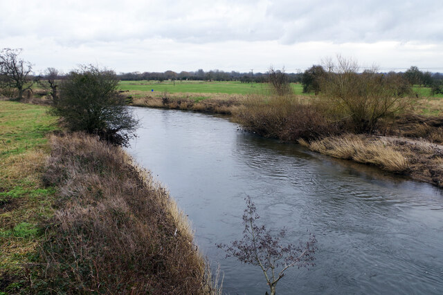
The village is known for its picturesque setting, surrounded by rolling green hills and scenic countryside. Its rural location offers residents a tranquil environment, making it an ideal place for those seeking a quiet and idyllic lifestyle away from the bustle of urban areas.

Although Ambaston is a relatively small village, it boasts a rich history. The area has evidence of human habitation dating back to the Iron Age, with archaeological discoveries including pottery and tools. The village's name has evolved over time, with variations such as Amaldestune and Alsestone recorded in historical documents.

Ambaston's economy primarily relies on agriculture, with some residents involved in farming and livestock rearing. The village itself does not have many commercial establishments, but amenities such as shops, schools, and healthcare facilities can be found in nearby towns.

For outdoor enthusiasts, Ambaston offers ample opportunities for exploration and recreation. The village is surrounded by beautiful countryside, making it a popular destination for walking, cycling, and horse riding. The nearby River Trent also provides opportunities for fishing and boating.

In summary, Ambaston is a charming village in Derbyshire, offering a peaceful rural lifestyle and stunning natural surroundings. With its rich history and close-knit community, it provides an inviting retreat for those seeking a slower pace of life.

If you have any feedback on the listing, please let us know in the comments section below.
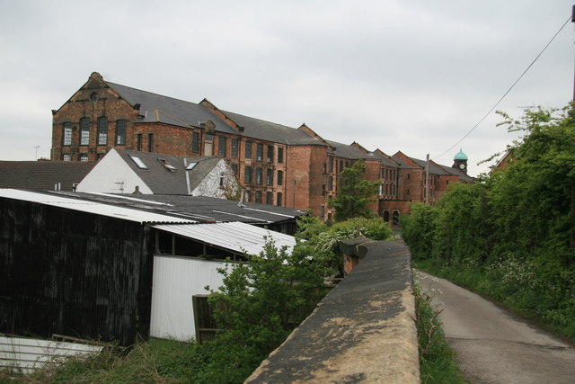
Ambaston Images

Images are sourced within 2km of 52.889684/-1.366956 or Grid Reference SK4232. Thanks to Geograph Open Source API. All images are credited.

The sign of the Victoria
The Victoria A surviving pub in Draycott.
The Victoria
A surviving pub in Draycott.
Victoria Mill, Draycott Dominating Draycott is the large Victoria Mills complete with clock tower which is a dominant feature for the area.  On inspection it is a fascinating building and  was built around the turn of the 20th century and was reputed to be the largest lace factory in the world. It has 228 large windows over its four floors. It was a tenement factory whereby the machinery was all rented out. Today the building has been converted to apartments and is Grade II listed.
Victoria Mill, Draycott
Dominating Draycott is the large Victoria Mills complete with clock tower which is a dominant feature for the area. On inspection it is a fascinating building and was built around the turn of the 20th century and was reputed to be the largest lace factory in the world. It has 228 large windows over its four floors. It was a tenement factory whereby the machinery was all rented out. Today the building has been converted to apartments and is Grade II listed.
Borrowash 1st railway station (site), Derbyshire Opened in 1839 by the Midland Counties Railway, soon to become the Midland Railway, on the line from Derby to Nottingham and Leicester, this station  was closed in 1871 when it was replaced by a more spacious one slightly closer to Derby.
View west at the surviving building, now a private residence. The platforms have long since been removed.
Borrowash 1st railway station (site), Derbyshire
Opened in 1839 by the Midland Counties Railway, soon to become the Midland Railway, on the line from Derby to Nottingham and Leicester, this station was closed in 1871 when it was replaced by a more spacious one slightly closer to Derby. View west at the surviving building, now a private residence. The platforms have long since been removed.
Borrowash 2nd railway station (site), Derbyshire Opened in 1871 by the Midland Railway on the lines from Derby to Nottingham and Leicester, this station replaced an 1839 one some 400m behind the camera position - see <a href="https://www.geograph.org.uk/photo/7136127">SK4134 : Borrowash 1st railway station (site), Derbyshire</a>. In turn, this station closed in 1966.
View north west towards Spondon and Derby. A sloping footpath to the right of the image took passengers down to platform level. 
Compare to <a href="https://www.geograph.org.uk/photo/1856336">SK4134 : Borrowash Station</a> taken from a similar position some 61 years earlier.
Borrowash 2nd railway station (site), Derbyshire
Opened in 1871 by the Midland Railway on the lines from Derby to Nottingham and Leicester, this station replaced an 1839 one some 400m behind the camera position - see SK4134 : Borrowash 1st railway station (site), Derbyshire. In turn, this station closed in 1966. View north west towards Spondon and Derby. A sloping footpath to the right of the image took passengers down to platform level. Compare to SK4134 : Borrowash Station taken from a similar position some 61 years earlier.
River Derwent near Borrowash Ratcliffe-on-Soar power station can be seen on the horizon.
River Derwent near Borrowash
Ratcliffe-on-Soar power station can be seen on the horizon.
Former canal lock being restored, Borrowash
Fallen tree and footbridge, Draycott Fields
Derby-Long Eaton Railway line, near Draycott
Market Street, Draycott
Derby Canal Path, Borrowash The Derby Canal used to run in a broad loop from Sandiacre on the Erewash Canal to Swarkestone on the Trent & Mersey. It ceased to operate as a commercial waterway in 1946 (after a long period of decline) and was formally abandoned in 1964. There are plans to restore it and some work has been done but an ambitious civil engineering project undertaken by occasional volunteer work parties is never going to make speedy progress. At the present rate it will be very many years, if ever, before boats return to Borrowash. Be that as it may, at least the route here, in the vicinity of what was Borrowash Top Lock, makes a pleasant path. Between the walls the Nottingham - Derby railway runs in a deep cutting.
Derby Canal Path, Borrowash
The Derby Canal used to run in a broad loop from Sandiacre on the Erewash Canal to Swarkestone on the Trent & Mersey. It ceased to operate as a commercial waterway in 1946 (after a long period of decline) and was formally abandoned in 1964. There are plans to restore it and some work has been done but an ambitious civil engineering project undertaken by occasional volunteer work parties is never going to make speedy progress. At the present rate it will be very many years, if ever, before boats return to Borrowash. Be that as it may, at least the route here, in the vicinity of what was Borrowash Top Lock, makes a pleasant path. Between the walls the Nottingham - Derby railway runs in a deep cutting.
Derby Canal, Borrowash Some restoration work has taken place here to the east of Station Road at Borrowash. Further along Borrowash Bottom Lock has also been restored. This is a magnificent effort but there is an enormous amount of work to do if the full 14 miles of the canal from Sandiacre to Swarkestone are ever to be restored.
Derby Canal, Borrowash
Some restoration work has taken place here to the east of Station Road at Borrowash. Further along Borrowash Bottom Lock has also been restored. This is a magnificent effort but there is an enormous amount of work to do if the full 14 miles of the canal from Sandiacre to Swarkestone are ever to be restored.
River Derwent, Borrowash Looking downstream from Derwent Bridge. The Derwent is a major Derbyshire river, rising on Bleaklow in the north of the county and flowing southwards to its confluence with the River Trent. For much of its course it passes through the Derbyshire hills but the character changes below Derby where it runs through the broad flat valley seen in this view with some extravagant meanders.
River Derwent, Borrowash
Looking downstream from Derwent Bridge. The Derwent is a major Derbyshire river, rising on Bleaklow in the north of the county and flowing southwards to its confluence with the River Trent. For much of its course it passes through the Derbyshire hills but the character changes below Derby where it runs through the broad flat valley seen in this view with some extravagant meanders.
New plaques on Borrowash Bridge The lower plaque is a replica of the original 1898 plaque which has become pretty much illegible. The upper plaque explains that the lower plaque was erected by Ockbrook & Borrowash Heritage Society in 2012. See <a href="https://www.geograph.org.uk/photo/7393138">SK4133 : Old plaque on Borrowash Bridge</a>.
New plaques on Borrowash Bridge
The lower plaque is a replica of the original 1898 plaque which has become pretty much illegible. The upper plaque explains that the lower plaque was erected by Ockbrook & Borrowash Heritage Society in 2012. See SK4133 : Old plaque on Borrowash Bridge.
Old plaque on Borrowash Bridge This old plaque has become pretty much illegible so a new replica plaque has been installed, see <a href="https://www.geograph.org.uk/photo/7393137">SK4133 : New plaques on Borrowash Bridge</a>.
Old plaque on Borrowash Bridge
This old plaque has become pretty much illegible so a new replica plaque has been installed, see SK4133 : New plaques on Borrowash Bridge.
Borrowash Bridge Borrowash Bridge is the last road crossing of the River Derwent before it reaches the River Trent. The bridge carries the B5010 between Borrowash and Elvaston. It was first opened in 1898 but is not wide enough for modern traffic so the roadway is controlled by traffic lights.
Borrowash Bridge
Borrowash Bridge is the last road crossing of the River Derwent before it reaches the River Trent. The bridge carries the B5010 between Borrowash and Elvaston. It was first opened in 1898 but is not wide enough for modern traffic so the roadway is controlled by traffic lights.
River Derwent, near Borrowash The River Derwent has a different look below Derby than it does north of the city. Here the hills have been left behind and the river meanders across a broad floodplain before reaching the River Trent.
River Derwent, near Borrowash
The River Derwent has a different look below Derby than it does north of the city. Here the hills have been left behind and the river meanders across a broad floodplain before reaching the River Trent.
Stream at Ambaston This sluggish stream drains the lake at Elvaston Castle into the River Derwent.
Stream at Ambaston
This sluggish stream drains the lake at Elvaston Castle into the River Derwent.
Show me another place!

Ambaston is located at Grid Ref: SK4232 (Lat: 52.889684, Lng: -1.366956)

Administrative County: Derbyshire

District: South Derbyshire

Police Authority: Derbyshire

What 3 Words

///strict.reinvest.vets. Near Borrowash, Derbyshire

Nearby Locations

Ambaston

Related Wikis

South East Derbyshire Rural District

South East Derbyshire was a rural district in Derbyshire, England from 1894 to 1974. It covered an area to the south-east of Derby. It was formed as Shardlow...

Elvaston, Derbyshire

Elvaston is a small village and civil parish in Derbyshire, England. The parish also includes two hamlets, Ambaston and Thulston, and a modern housing...

Draycott and Church Wilne

Draycott and Church Wilne is a civil parish within the Borough of Erewash, which is in the county of Derbyshire, England. Partially built up and otherwise...

Draycott, Derbyshire

Draycott is a village in the Erewash district of Derbyshire, England. It lies around 6 miles east of Derby and 3 miles south-west of Long Eaton. Draycott...

Nearby Amenities

Located within 500m of 52.889684,-1.366956
Post Box
Collection Times: Mo-Fr 17:00; Sa 10:30
Post Box Type: lamp
Ref: DE72 147
Royal Cypher: EIIR
Royal Cypher Wikidata: Q33102113
Source: survey
Lat/Long: 52.889512/-1.3649432
Ambaston
Place: village
Lat/Long: 52.8900868/-1.3645391
Barrier: stile
Steps: 2
Stile: stepover
Lat/Long: 52.8924743/-1.3694005
Barrier: stile
Steps: 2
Stile: stepover
Lat/Long: 52.8911376/-1.3685897
Barrier: stile
Steps: 2
Stile: stepover
Lat/Long: 52.8915341/-1.3687846
Barrier: stile
Steps: 1
Stile: stepover
Lat/Long: 52.8905731/-1.3663965
Information: board
Operator: Elvaston Parish Council
Tourism: information
Lat/Long: 52.8882812/-1.3642301
Defibrillator
Access: yes
Defibrillator Location: Mere Beck Ambaston
Emergency: defibrillator
Indoor: no
Ref GB The Circuit: 3F33D8E2-EB66-411F-866B-B10200899E61
Source: survey
Lat/Long: 52.889625/-1.3651467
Fixme: PBW probably continues to Nooning Ford
Lat/Long: 52.8913928/-1.3618488
Generator Method: photovoltaic
Generator Output Electricity: yes
Generator Source: solar
Generator Type: solar_photovoltaic_panel
Location: roof
Power: generator
Lat/Long: 52.8906689/-1.3646352
Generator Method: photovoltaic
Generator Output Electricity: yes
Generator Source: solar
Generator Type: solar_photovoltaic_panel
Location: roof
Power: generator
Lat/Long: 52.888243/-1.3639271
The data included in this document is from www.openstreetmap.org. The data is made available under ODbL.

Have you been to Ambaston?

Leave your review of Ambaston below (or comments, questions and feedback).