The Roundle Wood

Wood, Forest in East Lothian

Scotland

The Roundle Wood

Humbie Water seen from Kirk Bridge The main course of the East Lothian Tyne, it changes names quite often.
Humbie Water seen from Kirk Bridge Credit: Richard Webb

The Roundle Wood is a picturesque woodland located in East Lothian, Scotland. Spread across an area of approximately 20 acres, this enchanting forest is known for its natural beauty and diverse range of flora and fauna. The wood is situated in close proximity to the village of Gifford, making it easily accessible to visitors.

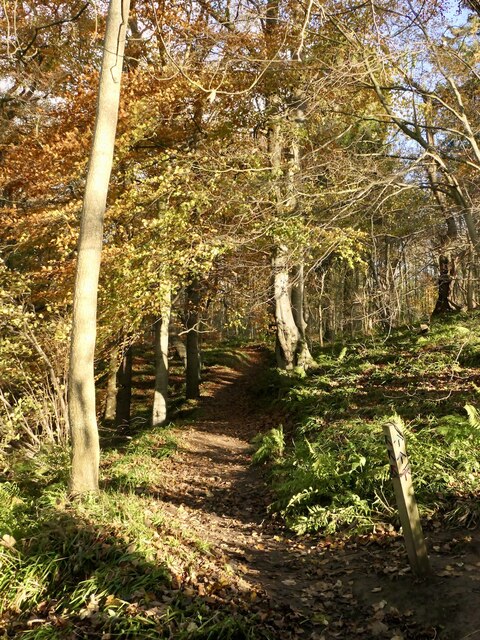
The Roundle Wood is characterized by its dense canopy of towering trees, including oak, beech, and birch. The woodland floor is covered in a lush carpet of moss, wildflowers, and ferns, providing a serene and peaceful ambiance. The wood is home to a variety of wildlife, such as red squirrels, badgers, and buzzards, making it a popular destination for nature enthusiasts and wildlife photographers.

There are several trails and paths that wind through the Roundle Wood, providing visitors with the opportunity to explore and discover its hidden treasures. These paths are well-maintained and suitable for walkers of all ages and abilities. Additionally, there are picnic areas scattered throughout the wood, allowing visitors to relax and enjoy the tranquil surroundings.

The Roundle Wood offers a unique and immersive experience, allowing visitors to connect with nature and escape the hustle and bustle of everyday life. Whether it's a leisurely stroll, birdwatching, or simply enjoying a picnic, this woodland provides a serene and rejuvenating environment for all who visit.

If you have any feedback on the listing, please let us know in the comments section below.

The Roundle Wood Images

Images are sourced within 2km of 55.862586/-2.863213 or Grid Reference NT4663. Thanks to Geograph Open Source API. All images are credited.

Humbie Water seen from Kirk Bridge The main course of the East Lothian Tyne, it changes names quite often.
Humbie Water seen from Kirk Bridge
The main course of the East Lothian Tyne, it changes names quite often.
Track, The Roundle Wood, Humbie Climbing away from Kirk Bridge.
Track, The Roundle Wood, Humbie
Climbing away from Kirk Bridge.
Path, Church Wood, Humbie Part of a series of waymarked paths in the wood.
Path, Church Wood, Humbie
Part of a series of waymarked paths in the wood.
Church Wood, Humbie Waymarked paths from Humbie Kirk.
Church Wood, Humbie
Waymarked paths from Humbie Kirk.
Path, Church Wood, Humbie
Burn crossing, Church Wood The bridge shown by the Ordnance Survey is no longer there. The burn drops sharply to the Humbie Water here and there is a waterfall just downstream.
Burn crossing, Church Wood
The bridge shown by the Ordnance Survey is no longer there. The burn drops sharply to the Humbie Water here and there is a waterfall just downstream.
Burn, Church Wood On the waymarked paths, there is no bridge.
Burn, Church Wood
On the waymarked paths, there is no bridge.
Path, Church Wood, Humbie
Church Wood, Humbie
Church Wood, Humbie
Path, Church Wood, Humbie The well built path travels along the edge of a drop to the Humbie Water.
Path, Church Wood, Humbie
The well built path travels along the edge of a drop to the Humbie Water.
Humbie Water, Church Wood The biggest of the small rivers which make up the Tyne catchment. It changes name frequently ending up as the River Tyne when the Tyne Water joins upstream of Haddington. Here is flows through a small wooded gorge.
Humbie Water, Church Wood
The biggest of the small rivers which make up the Tyne catchment. It changes name frequently ending up as the River Tyne when the Tyne Water joins upstream of Haddington. Here is flows through a small wooded gorge.
Beech bark carving, Church Wood
Humbie Water, Church Wood The biggest of the small rivers which make up the Tyne catchment. It changes name frequently ending up as the River Tyne when the Tyne Water joins upstream of Haddington. Here is flows through a small wooded gorge.
Humbie Water, Church Wood
The biggest of the small rivers which make up the Tyne catchment. It changes name frequently ending up as the River Tyne when the Tyne Water joins upstream of Haddington. Here is flows through a small wooded gorge.
Highlea Wood, Humbie Replanted area. Any paths mapped here are fictitious. There is a faint path along the river.
Highlea Wood, Humbie
Replanted area. Any paths mapped here are fictitious. There is a faint path along the river.
Path beside the Humbie Water A very faint path beside a big cleared area.
Path beside the Humbie Water
A very faint path beside a big cleared area.
Bend in the Humbie Water The bridge mapped by the Ordnance Survey is long gone.
Bend in the Humbie Water
The bridge mapped by the Ordnance Survey is long gone.
Replanted area, Highlea Wood
Show me another place!

The Roundle Wood is located at Grid Ref: NT4663 (Lat: 55.862586, Lng: -2.863213)

Unitary Authority: East Lothian

Police Authority: The Lothians and Scottish Borders

What 3 Words

///elect.coverings.dude. Near Pencaitland, East Lothian

Nearby Locations

Lady Wood The Roundle Wood

Related Wikis

Nearby Amenities

Located within 500m of 55.862586,-2.863213
New Mains Farm
Naptan AtcoCode: 627028365
Naptan Bearing: SW
Naptan BusStopType: CUS
Naptan CommonName: New Mains Farm
Naptan Indicator: at New Mains Road End
Naptan NaptanCode: 58234973
Naptan Street: B6371
Naptan Verified: no
Source: naptan_import
Lat/Long: 55.8630384/-2.8654777
Building: farm
Lat/Long: 55.8648723/-2.8677415
Man Made: tower
Lat/Long: 55.8595623/-2.8686335
Power: pole
Lat/Long: 55.8644662/-2.8704857
Power: pole
Lat/Long: 55.8644685/-2.869621
Power: pole
Lat/Long: 55.8644393/-2.8683708
The data included in this document is from www.openstreetmap.org. The data is made available under ODbL.

Have you been to The Roundle Wood?

Leave your review of The Roundle Wood below (or comments, questions and feedback).