Low Wood

Wood, Forest in Fife

Scotland

Low Wood

Benchmark location, East Flisk This benchmark took quite a bit of finding.  We covered it back up as best we could once we had photographed it.  The original stone has been dislodged and the benchmark is lying on its side.
Benchmark location, East Flisk Credit: Becky Williamson

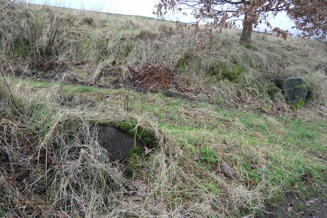
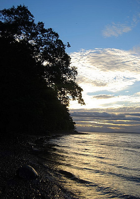
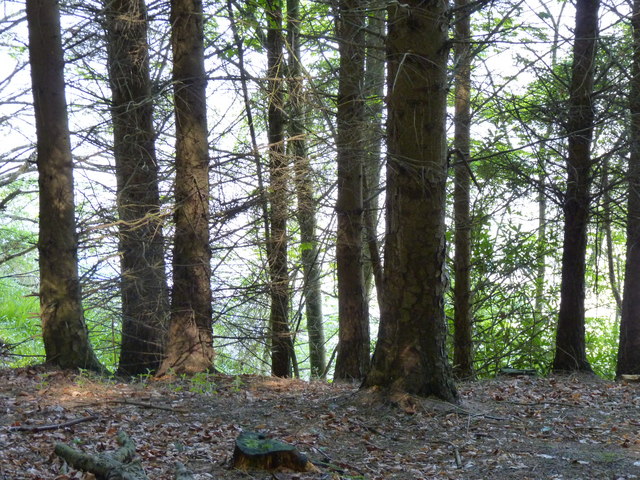
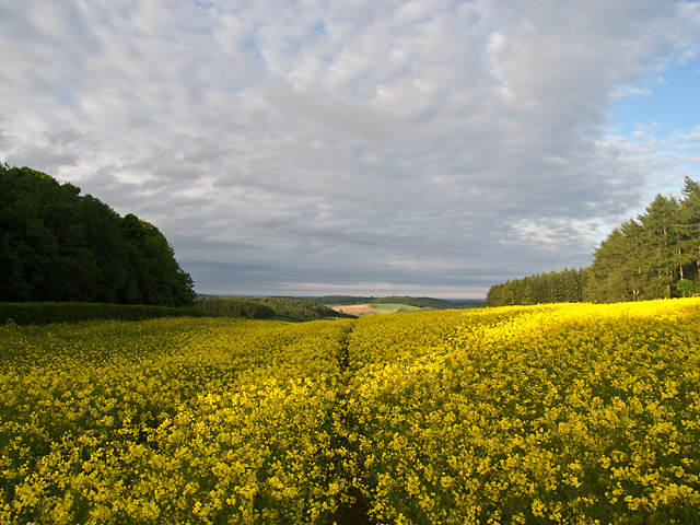
Low Wood is a picturesque forest located in Fife, Scotland. Situated in the eastern part of the country, it covers an area of approximately 100 acres and is known for its abundant wildlife and natural beauty. The forest is primarily composed of a mixture of native tree species, including oak, birch, and pine, creating a diverse and enchanting woodland environment.

The forest is a popular destination for nature lovers, hikers, and outdoor enthusiasts. It offers a network of well-maintained trails that wind through the trees, providing opportunities for leisurely walks or more challenging hikes. Along these trails, visitors can admire the stunning flora and fauna that call Low Wood their home. The forest is home to a variety of bird species, including woodpeckers, owls, and songbirds, making it a haven for birdwatchers.

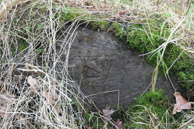
Besides its natural beauty, Low Wood also has historical significance. The forest is believed to have been used for timber production and charcoal making in the past, with remnants of old kilns and charcoal platforms still visible today. Additionally, there is evidence of prehistoric settlements in the area, highlighting the long-standing human connection to the forest.

Overall, Low Wood offers a serene and tranquil escape from the hustle and bustle of everyday life. Whether one seeks a peaceful walk in nature, a chance to spot wildlife, or a glimpse into the past, this enchanting forest provides a truly immersive and memorable experience.

If you have any feedback on the listing, please let us know in the comments section below.

Low Wood Images

Images are sourced within 2km of 56.39965/-3.0754909 or Grid Reference NO3323. Thanks to Geograph Open Source API. All images are credited.

Benchmark location, East Flisk This benchmark took quite a bit of finding.  We covered it back up as best we could once we had photographed it.  The original stone has been dislodged and the benchmark is lying on its side.
Benchmark location, East Flisk
This benchmark took quite a bit of finding. We covered it back up as best we could once we had photographed it. The original stone has been dislodged and the benchmark is lying on its side.
Forester's Cottage sign There is an Ordnance Survey benchmark just visible on photo on large stone between house sign and plant pot.
Forester's Cottage sign
There is an Ordnance Survey benchmark just visible on photo on large stone between house sign and plant pot.
East Flisk Farm On south side of River Tay.
East Flisk Farm
On south side of River Tay.
Benchmark on Forester's Cottage, Hazelton Walls Ordnance Survey benchmark, described on database at <span class="nowrap"><a title="https://www.bench-marks.org.uk/bm37777" rel="nofollow ugc noopener" href="https://www.bench-marks.org.uk/bm37777">Link</a><img style="margin-left:2px;" alt="External link" title="External link - shift click to open in new window" src="https://s1.geograph.org.uk/img/external.png" width="10" height="10"/></span>.
Benchmark on Forester's Cottage, Hazelton Walls
Ordnance Survey benchmark, described on database at LinkExternal link.
Ordnance Survey benchmark on fallen stone, East Flisk Described on database at <span class="nowrap"><a title="https://www.bench-marks.org.uk/bm211340" rel="nofollow ugc noopener" href="https://www.bench-marks.org.uk/bm211340">Link</a><img style="margin-left:2px;" alt="External link" title="External link - shift click to open in new window" src="https://s1.geograph.org.uk/img/external.png" width="10" height="10"/></span>.  See also <a href="https://www.geograph.org.uk/photo/7687235">NO3222 : Benchmark location, East Flisk</a>.
Ordnance Survey benchmark on fallen stone, East Flisk
Described on database at LinkExternal link. See also NO3222 : Benchmark location, East Flisk.
Forester's Cottage, Hazelton Walls There is an Ordnance Survey benchmark on this cottage. See <a href="https://www.geograph.org.uk/photo/7687257">NO3321 : Benchmark on Forester's Cottage, Hazelton Walls</a>.
Forester's Cottage, Hazelton Walls
There is an Ordnance Survey benchmark on this cottage. See NO3321 : Benchmark on Forester's Cottage, Hazelton Walls.
Evening Glow This turned out to be one of the best sunsets ever seen over Balmerino Bay
Evening Glow
This turned out to be one of the best sunsets ever seen over Balmerino Bay
Evening Foreshore Catching the sunset colours from the narrow, slippy shoreline.
Evening Foreshore
Catching the sunset colours from the narrow, slippy shoreline.
Trees above the Tay A glimpse of the Firth of Tay through the forest that lines the Fife shoreline at this point.
Trees above the Tay
A glimpse of the Firth of Tay through the forest that lines the Fife shoreline at this point.
Flisk Wood and the River Tay Flisk wood adjacent to a tidal section of the River Tay. The small burn that flows through Corbie Den enters the Tay to the right of the image.
Flisk Wood and the River Tay
Flisk wood adjacent to a tidal section of the River Tay. The small burn that flows through Corbie Den enters the Tay to the right of the image.
Flisk Wood Trees and leaf canopy in Flisk Wood, which is the largest area of mixed deciduous woodland in Fife. The wood supports the growth of several species of rare plants, and is designated as a SSSI.
Flisk Wood
Trees and leaf canopy in Flisk Wood, which is the largest area of mixed deciduous woodland in Fife. The wood supports the growth of several species of rare plants, and is designated as a SSSI.
Track in Flisk Wood
Track in Flisk Wood
Corbie Den Fallen trees obscuring the Corbie Den, a small ravine eroded by an unnamed burn flowing into the River Tay from the southern flank of Corbie Hill.
Corbie Den
Fallen trees obscuring the Corbie Den, a small ravine eroded by an unnamed burn flowing into the River Tay from the southern flank of Corbie Hill.
Oil-seed rape field near Coultra An oil-seed rape field at Coultra, with plants nearing the end of flowering. This crop is surprisingly tall - the camera was held above my head to take this image. The hedging (left of image) marks the position of a minor road on cycle route NCN1 - this section running from Newburgh to Newport on Tay offers excellent cycling, with good views over the Tay estuary. See Sustrans for route mapping: <span class="nowrap"><a title="http://www.sustrans.org.uk/" rel="nofollow ugc noopener" href="http://www.sustrans.org.uk/">Link</a><img style="margin-left:2px;" alt="External link" title="External link - shift click to open in new window" src="https://s1.geograph.org.uk/img/external.png" width="10" height="10"/></span>
Oil-seed rape field near Coultra
An oil-seed rape field at Coultra, with plants nearing the end of flowering. This crop is surprisingly tall - the camera was held above my head to take this image. The hedging (left of image) marks the position of a minor road on cycle route NCN1 - this section running from Newburgh to Newport on Tay offers excellent cycling, with good views over the Tay estuary. See Sustrans for route mapping: LinkExternal link
The fields of East Fisk With farm buildings and the River Tay beyond.
The fields of East Fisk
With farm buildings and the River Tay beyond.
View across the Tay The River Tay, viewed from the Fife shoreline near Thornton. The river is lined by shingle and mud here.
View across the Tay
The River Tay, viewed from the Fife shoreline near Thornton. The river is lined by shingle and mud here.
South bank of the River Tay Mud lining the south bank of the River Tay. Streams draining from north Fife have eroded small channels in the mudbanks.
South bank of the River Tay
Mud lining the south bank of the River Tay. Streams draining from north Fife have eroded small channels in the mudbanks.
Sandstone outcrop by the River Tay An outcrop of sandstone on the south bank of the River Tay. This sedimentary bedrock formed 354-370 million years ago in the Devonian Period. For more details see Geology of Britain Viewer <span class="nowrap"><a title="http://mapapps.bgs.ac.uk/geologyofbritain/home.html" rel="nofollow ugc noopener" href="http://mapapps.bgs.ac.uk/geologyofbritain/home.html">Link</a><img style="margin-left:2px;" alt="External link" title="External link - shift click to open in new window" src="https://s1.geograph.org.uk/img/external.png" width="10" height="10"/></span>
Sandstone outcrop by the River Tay
An outcrop of sandstone on the south bank of the River Tay. This sedimentary bedrock formed 354-370 million years ago in the Devonian Period. For more details see Geology of Britain Viewer LinkExternal link
Show me another place!

Low Wood is located at Grid Ref: NO3323 (Lat: 56.39965, Lng: -3.0754909)

Unitary Authority: Fife

Police Authority: Fife

What 3 Words

///pelt.fiery.freedom. Near Invergowrie, Perth & Kinross

Nearby Locations

Low Wood

Related Wikis

Birkhill Castle

Birkhill Castle is a stately home, the residence of the Earl of Dundee, located on the banks of the River Tay, a short drive from St. Andrews. The castle...

Flisk

Flisk (Scottish Gaelic: Fleasg meaning "Stalk" or "Rod") was a parish in Fife, Scotland. According to the 1853 Gazetteer, in part: "Flisk parish is bounded...

Balmerino

Balmerino is a small village and former monastic centre in Fife, Scotland. It is the home of Balmerino Abbey and the former abbots of Balmerino who were...

Balmerino Abbey

Balmerino Abbey, or St Edward's Abbey, in Balmerino, Fife, Scotland, was a Cistercian monastic community which has been ruinous since the 16th century...

Nearby Amenities

Located within 500m of 56.39965,-3.0754909
Material: wood
Power: pole
Lat/Long: 56.3955056/-3.0761504
Material: wood
Power: pole
Lat/Long: 56.3951775/-3.0755872
Material: wood
Power: pole
Lat/Long: 56.3960326/-3.0733019
Material: wood
Power: pole
Lat/Long: 56.3964482/-3.0722237
Material: wood
Power: pole
Lat/Long: 56.3968401/-3.0711401
Material: wood
Power: pole
Lat/Long: 56.3976885/-3.0689326
Material: wood
Power: pole
Lat/Long: 56.3972587/-3.0700564
Material: wood
Power: pole
Lat/Long: 56.3980247/-3.067975
Power: pole
Lat/Long: 56.3958146/-3.0766935
Power: pole
Lat/Long: 56.3966067/-3.073986
Power: pole
Lat/Long: 56.3971871/-3.0747389
Power: pole
Lat/Long: 56.3978487/-3.07562
The data included in this document is from www.openstreetmap.org. The data is made available under ODbL.

Have you been to Low Wood?

Leave your review of Low Wood below (or comments, questions and feedback).