Cauldhame

Settlement in Stirlingshire

Scotland

Cauldhame

Fast growing grass Hillside at Kippen, above the sewage treatment plant.
Fast growing grass Credit: Richard Webb

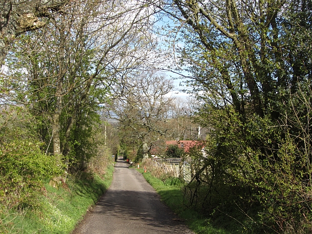
Cauldhame is a small village located in the region of Stirlingshire, Scotland. Situated approximately 5 miles northeast of the town of Dunblane, Cauldhame is nestled within the picturesque countryside of Central Scotland. The village is surrounded by rolling hills and expansive fields, providing a tranquil and idyllic setting for its residents.

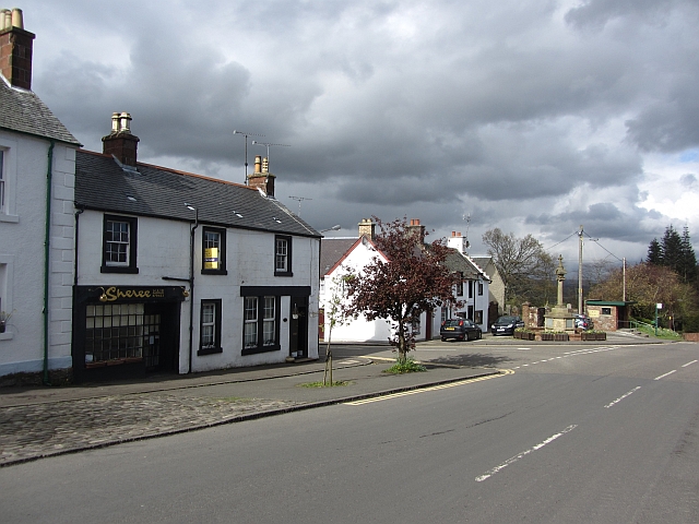
With a population of around 300 inhabitants, Cauldhame exudes a strong sense of community and offers a peaceful and close-knit environment. The village primarily consists of traditional stone-built houses, adding to its charming and quaint appeal. The local architecture reflects the region's rich history and heritage.

Cauldhame is known for its beautiful natural landscapes, making it a haven for outdoor enthusiasts. The village is surrounded by numerous walking and cycling trails, offering opportunities for exploration and adventure. Additionally, the nearby River Allan provides a scenic spot for fishing and leisurely walks along its banks.

Although small in size, Cauldhame boasts a few amenities to cater to its residents' needs. These include a village hall, a local grocery store, and a primary school. For further amenities, residents can easily access the nearby town of Dunblane, which offers a wider range of shops, restaurants, and services.

Overall, Cauldhame is a peaceful and picturesque village that offers a rural lifestyle with close proximity to larger towns. Its natural beauty and strong sense of community make it an attractive place to live for those seeking a tranquil and close-knit environment.

If you have any feedback on the listing, please let us know in the comments section below.

Cauldhame Images

Images are sourced within 2km of 56.122673/-4.181804 or Grid Reference NS6494. Thanks to Geograph Open Source API. All images are credited.

Fast growing grass Hillside at Kippen, above the sewage treatment plant.
Fast growing grass
Hillside at Kippen, above the sewage treatment plant.
Main Street, Kippen
Main Street, Kippen
Old Military Road Once the road between Dumbarton and Stirling, now a no through road lane.
Old Military Road
Once the road between Dumbarton and Stirling, now a no through road lane.
Old road Probably an old alignment of the A811.
Old road
Probably an old alignment of the A811.
Grassland near Kippen Land starts to slope up from the vast Forth flood plain.
Grassland near Kippen
Land starts to slope up from the vast Forth flood plain.
Kippen Post Office Main Street, Kippen.
Kippen Post Office
Main Street, Kippen.
Ladylands Farm buildings on the edge of Flanders Moss - a vast bog, much of which was cleared away revealing good agricultural land.
Ladylands
Farm buildings on the edge of Flanders Moss - a vast bog, much of which was cleared away revealing good agricultural land.
A811, Crawfordston A  large barn next to the A811.
A811, Crawfordston
A large barn next to the A811.
Field above the Boquhan Burn The burn flows through a deep ravine which looks like it might repay exploration. A long focus brings in the Perthshire Highlands in the background.
Field above the Boquhan Burn
The burn flows through a deep ravine which looks like it might repay exploration. A long focus brings in the Perthshire Highlands in the background.
Approaching lay by on Kippen by pass A811. Lay by is on the right where the white van is parked
Approaching lay by on Kippen by pass
A811. Lay by is on the right where the white van is parked
A811 towards Crawfordston
NW from B822 Kippen - Campsie road to Fintry Hills  and Ben Lomond Ben Lomond (3,192 ft.) is prominent on the horizon.
NW from B822 Kippen - Campsie road to Fintry Hills and Ben Lomond
Ben Lomond (3,192 ft.) is prominent on the horizon.
Hills of Menteith from Kippen Northward view over Tay Valley to Lake of Menteith (barely visible), the Hills of Menteith and on the horizon Ben Ledi (2,845 ft.).
Hills of Menteith from Kippen
Northward view over Tay Valley to Lake of Menteith (barely visible), the Hills of Menteith and on the horizon Ben Ledi (2,845 ft.).
Remnant hedge by the roadside at Middle Kerse
Strewiebank at Kippen
Gathering pen by the site of an old railway line The line was finally closed in the 1960s.
Gathering pen by the site of an old railway line
The line was finally closed in the 1960s.
Incoming Inclement Weather In the end, only a few drops of rain fell upon entering Kippen.  This view looks over the Carse Of Stirling and the A811 is visible in the middle distance.
Incoming Inclement Weather
In the end, only a few drops of rain fell upon entering Kippen. This view looks over the Carse Of Stirling and the A811 is visible in the middle distance.
Former United Free Church, Kippen By F McKinnon, dating from 1879. Now converted into apartments and called Kingdom Court.
Former United Free Church, Kippen
By F McKinnon, dating from 1879. Now converted into apartments and called Kingdom Court.
Show me another place!

Cauldhame is located at Grid Ref: NS6494 (Lat: 56.122673, Lng: -4.181804)

Unitary Authority: Stirling

Police Authority: Forth Valley

What 3 Words

///daunting.estimates.monkeys. Near Kippen, Stirling

Related Wikis

Kippen

Kippen is a village in west Stirlingshire, Scotland. It lies between the Gargunnock Hills and the Fintry Hills and overlooks the Carse of Forth to the...

Fairfield Siding railway station

Fairfield Siding railway station co-served the village of Kippen, Stirling, Scotland, from 1861 to 1866 on the Forth and Clyde Junction Railway. ��2�...

Ladylands Platform railway station

Ladylands Platform railway station co-served the village of Kippen, Stirling, Scotland, from 1861 to 1934 on the Forth and Clyde Junction Railway. ��2...

Kippen railway station

Kippen railway station co-served the village of Kippen, Stirling, Scotland, from 1856 to 1934 on the Forth and Clyde Junction Railway. == History == The...

Nearby Amenities

Located within 500m of 56.122673,-4.181804
Generator Method: photovoltaic
Generator Output Electricity: yes
Generator Source: solar
Generator Type: solar_photovoltaic_panel
Location: roof
Power: generator
Lat/Long: 56.1255382/-4.176693
Generator Method: photovoltaic
Generator Output Electricity: yes
Generator Source: solar
Generator Type: solar_photovoltaic_panel
Location: roof
Power: generator
Lat/Long: 56.124538/-4.1748288
Generator Method: photovoltaic
Generator Output Electricity: yes
Generator Source: solar
Generator Type: solar_photovoltaic_panel
Location: roof
Power: generator
Lat/Long: 56.1245007/-4.1750783
Generator Method: photovoltaic
Generator Output Electricity: yes
Generator Source: solar
Generator Type: solar_photovoltaic_panel
Location: roof
Power: generator
Lat/Long: 56.1244125/-4.1753143
Generator Method: photovoltaic
Generator Output Electricity: yes
Generator Source: solar
Generator Type: solar_photovoltaic_panel
Location: roof
Power: generator
Lat/Long: 56.1243631/-4.1753304
Generator Method: photovoltaic
Generator Output Electricity: yes
Generator Source: solar
Generator Type: solar_photovoltaic_panel
Location: roof
Power: generator
Lat/Long: 56.1243332/-4.1759124
Generator Method: photovoltaic
Generator Output Electricity: yes
Generator Source: solar
Generator Type: solar_photovoltaic_panel
Location: roof
Power: generator
Lat/Long: 56.1242899/-4.1757435
Power: pole
Lat/Long: 56.1214055/-4.1895253
Power: pole
Lat/Long: 56.1214229/-4.1886279
Power: pole
Lat/Long: 56.1214404/-4.1877536
Power: pole
Lat/Long: 56.1214323/-4.1865843
Power: pole
Lat/Long: 56.1208411/-4.1862789
Power: pole
Lat/Long: 56.1202313/-4.1859965
Power: pole
Lat/Long: 56.1196342/-4.1856932
Power: pole
Lat/Long: 56.1190605/-4.1854338
Power: pole
Lat/Long: 56.1186664/-4.1843399
Power: pole
Lat/Long: 56.1182594/-4.1831957
Power: pole
Lat/Long: 56.1184518/-4.1822021
Power: pole
Lat/Long: 56.1186536/-4.1811792
Power: pole
Lat/Long: 56.1188413/-4.1801689
Power: pole
Lat/Long: 56.1190337/-4.1791419
Power: pole
Lat/Long: 56.1192028/-4.1782613
Power: pole
Lat/Long: 56.1194838/-4.1767322
Power: pole
Lat/Long: 56.1221377/-4.1860206
Power: pole
Lat/Long: 56.122786/-4.1855144
Power: pole
Lat/Long: 56.1234832/-4.184981
Power: pole
Lat/Long: 56.1240872/-4.1844894
Power: pole
Lat/Long: 56.1246923/-4.1847739
Power: pole
Lat/Long: 56.1252403/-4.1850228
Power: pole
Lat/Long: 56.1258279/-4.1853491
Power: pole
Lat/Long: 56.1261368/-4.184115
Power: pole
Lat/Long: 56.1264574/-4.1829102
Power: pole
Lat/Long: 56.1265787/-4.1814459
Power: pole
Lat/Long: 56.1266918/-4.1800863
Power: pole
Lat/Long: 56.1268119/-4.1787016
Power: pole
Lat/Long: 56.1263467/-4.1772834
The data included in this document is from www.openstreetmap.org. The data is made available under ODbL.

Have you been to Cauldhame?

Leave your review of Cauldhame below (or comments, questions and feedback).