Catterline

Settlement in Kincardineshire

Scotland

Catterline

Looking down into Trollochy Trollochy is a short, cliff girt inlet below Crawton.
Looking down into Trollochy Credit: Gordon Hatton

Catterline is a charming coastal village located in the historical county of Kincardineshire in Scotland. Situated about 15 miles south of Aberdeen, it is nestled on the east coast of the country, overlooking the North Sea. Known for its picturesque beauty and rich heritage, Catterline attracts locals and tourists alike.

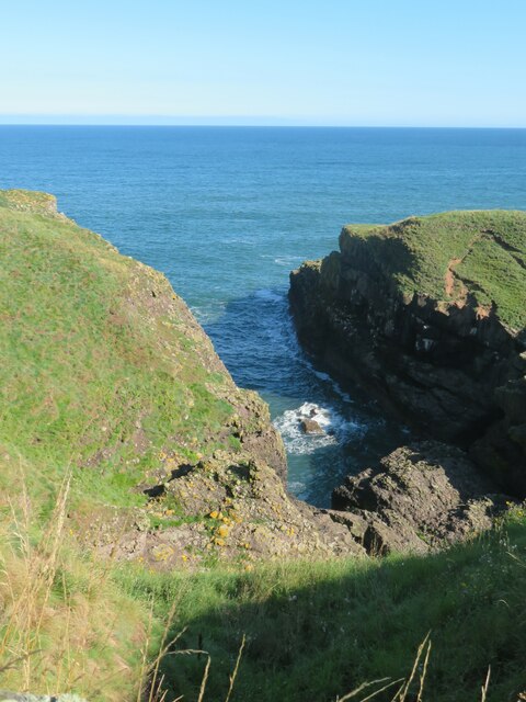
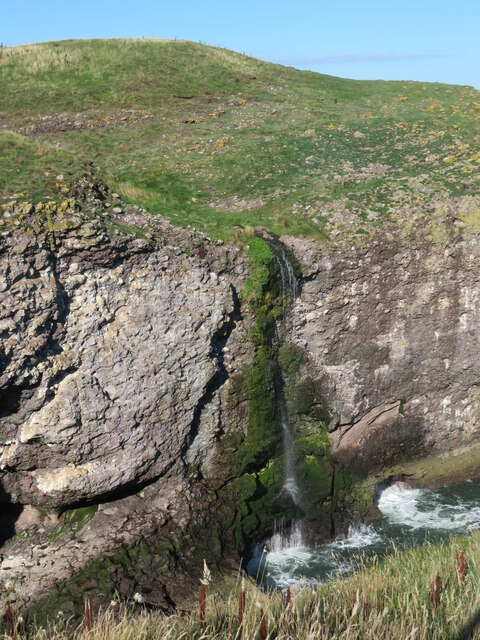
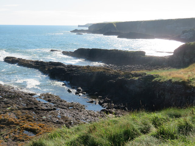
The village is famous for its stunning cliff-top setting, offering breathtaking views of the rugged coastline and expansive sea. Its rugged landscape and dramatic cliffs have long been a source of inspiration for artists, including the renowned Scottish painter Joan Eardley. Catterline is often associated with the Catterline School of artists, who found inspiration in its natural surroundings.

Catterline is home to a tight-knit community that takes pride in its history and traditions. Its population is relatively small, with around 150 residents. The village boasts a primary school, a church, and a community hall, which serve as focal points for local gatherings and events.

For outdoor enthusiasts, Catterline offers a range of activities. The coastline provides excellent opportunities for coastal walks, bird-watching, and fishing. The nearby Dunnottar Castle, a stunning cliff-top fortress, is also a popular attraction for visitors.

In terms of amenities, Catterline has a pub that serves as a social hub for locals and visitors alike. However, for more extensive services and amenities, residents typically rely on nearby towns such as Stonehaven or Aberdeen.

Overall, Catterline’s idyllic location, artistic heritage, and strong sense of community make it a truly captivating destination for those seeking a tranquil retreat by the sea.

If you have any feedback on the listing, please let us know in the comments section below.

Catterline Images

Images are sourced within 2km of 56.897879/-2.217662 or Grid Reference NO8678. Thanks to Geograph Open Source API. All images are credited.

Looking down into Trollochy Trollochy is a short, cliff girt inlet below Crawton.
Looking down into Trollochy
Trollochy is a short, cliff girt inlet below Crawton.
Waterfall into the sea at Crawton A wee burn makes a dramatic plunge into the cliff bound inlet of Trollochy at Crawton.
Waterfall into the sea at Crawton
A wee burn makes a dramatic plunge into the cliff bound inlet of Trollochy at Crawton.
Rock ribs extending out into the sea at Crawton The view south from the small headland at Crawton where rocky reefs defy the waves. The view extends along Crawton Bay.
Rock ribs extending out into the sea at Crawton
The view south from the small headland at Crawton where rocky reefs defy the waves. The view extends along Crawton Bay.
Puffin Puffins breed on offshore islands or tall sea cliffs,  outside the breeding season it lives at sea.  They catch small fish such as sand eels, sprat, herring and caplin although it eats many others.
Puffin
Puffins breed on offshore islands or tall sea cliffs, outside the breeding season it lives at sea. They catch small fish such as sand eels, sprat, herring and caplin although it eats many others.
Tod Lighthouse
Tod Lighthouse
Baler at work Tractor with baler working a harvested field near Cowieswells Farm.
Baler at work
Tractor with baler working a harvested field near Cowieswells Farm.
Todhead Light. Todhead Lighthouse amid farmland and the North Sea beyond.
Todhead Light.
Todhead Lighthouse amid farmland and the North Sea beyond.
Todhead Lighthouse The lighthouse at Todhead Point.
Todhead Lighthouse
The lighthouse at Todhead Point.
Lambs by Todhead Lambs in a field by Todhead.
Lambs by Todhead
Lambs in a field by Todhead.
Todhead Pasture Sheep grazing by Todhead with Braidon Bay in the background.
Todhead Pasture
Sheep grazing by Todhead with Braidon Bay in the background.
Fernieflatt Farm Lying between Kinneff and Braidon Bay.
Fernieflatt Farm
Lying between Kinneff and Braidon Bay.
By Fernieflatt Fernieflatt Farm by Kinneff.
By Fernieflatt
Fernieflatt Farm by Kinneff.
Glasslin Burn The wooded sides of the Glasslin Burn by Fernieflatt.
Glasslin Burn
The wooded sides of the Glasslin Burn by Fernieflatt.
Daffodil Fields Rows of Daffodils growing by Braidon.
Daffodil Fields
Rows of Daffodils growing by Braidon.
Sheep grazing above Todhead Light Photographer is standing at the verge of the narrow access road.
Sheep grazing above Todhead Light
Photographer is standing at the verge of the narrow access road.
Conglomerate shoreline south of Todhead Point
Approaching the Barras turnoff from the A92 Photographer is above the paved roadway surface looking in the southbound direction along A92.
Approaching the Barras turnoff from the A92
Photographer is above the paved roadway surface looking in the southbound direction along A92.
Access drive to Fernieflatt Photographer is above the paved surface of the minor road junction.
Access drive to Fernieflatt
Photographer is above the paved surface of the minor road junction.
Show me another place!

Catterline is located at Grid Ref: NO8678 (Lat: 56.897879, Lng: -2.217662)

Unitary Authority: Aberdeenshire

Police Authority: North East

What 3 Words

///arrives.crate.splinters. Near Inverbervie, Aberdeenshire

Nearby Locations

Catterline

Related Wikis

Catterline

Catterline is a coastal village on the North Sea in Aberdeenshire, Scotland. It is situated about 5 miles (8.0 km) south of Stonehaven; nearby to the...

Crawton

Crawton is a former fishing community on the southeast Aberdeenshire coast in Scotland, deserted since 1927. Approximately three miles south of Stonehaven...

Fowlsheugh

Fowlsheugh is a coastal nature reserve in Kincardineshire, northeast Scotland, known for its 70-metre-high (230 ft) cliff formations and habitat supporting...

Craiglethy

Craiglethy (Scottish Gaelic: Creag Liathach - meaning grey rock) is a small island/skerry off Fowlsheugh on the east coast of Aberdeenshire, Scotland in...

Nearby Amenities

Located within 500m of 56.897879,-2.217662
Source: PGS
Lat/Long: 56.8935067/-2.2161496
Source: PGS
Lat/Long: 56.8938006/-2.216368
Source: PGS
Lat/Long: 56.8940149/-2.21643
Source: PGS
Lat/Long: 56.8945888/-2.2163589
Source: PGS
Lat/Long: 56.895/-2.2160781
Source: PGS
Lat/Long: 56.8952572/-2.2156056
Source: PGS
Lat/Long: 56.8953732/-2.2151724
Source: PGS
Lat/Long: 56.8951262/-2.2142594
Source: PGS
Lat/Long: 56.8950858/-2.2136658
Source: PGS
Lat/Long: 56.894985/-2.2130138
Source: PGS
Lat/Long: 56.8949634/-2.2127219
Source: PGS
Lat/Long: 56.8951296/-2.2125192
Source: PGS
Lat/Long: 56.895373/-2.2125728
Source: PGS
Lat/Long: 56.8957057/-2.2132516
Source: PGS
Lat/Long: 56.8960534/-2.2126728
Source: PGS
Lat/Long: 56.8961665/-2.212014
Source: PGS
Lat/Long: 56.8964217/-2.2113531
Source: PGS
Lat/Long: 56.8964739/-2.2098615
Created By: almien_coastlines
Source: PGS
Lat/Long: 56.896841/-2.209944
Catterline
Name Sco: Caitterlin
Place: village
Source: GPS
Wikidata: Q5054079
Wikipedia: en:Catterline
Lat/Long: 56.8979509/-2.2178874
Catterline Bay
Natural: bay
Lat/Long: 56.8942266/-2.2143012
Power: pole
Lat/Long: 56.8956513/-2.2237674
Power: pole
Lat/Long: 56.8961414/-2.223009
Power: pole
Lat/Long: 56.8966258/-2.2222759
Power: pole
Lat/Long: 56.8971101/-2.2215239
Power: pole
Lat/Long: 56.8976049/-2.2207508
Power: pole
Lat/Long: 56.8981628/-2.2198808
Power: pole
Lat/Long: 56.8985034/-2.2193668
Power: pole
Lat/Long: 56.8988968/-2.2187643
Power: pole
Lat/Long: 56.8992207/-2.2182366
Power: pole
Lat/Long: 56.8997568/-2.2174171
Power: pole
Lat/Long: 56.9002779/-2.2166082
Power: pole
Lat/Long: 56.9008071/-2.2157972
Power: pole
Lat/Long: 56.9013305/-2.2149862
Power: pole
Lat/Long: 56.9018366/-2.2142025
Power: pole
Lat/Long: 56.898684/-2.2199187
Power: pole
Lat/Long: 56.8988945/-2.2205464
Power: pole
Lat/Long: 56.8992857/-2.2208751
Power: pole
Lat/Long: 56.899885/-2.2213596
Power: pole
Lat/Long: 56.9004303/-2.2224234
Power: pole
Lat/Long: 56.9009054/-2.2233566
Power: pole
Lat/Long: 56.9014375/-2.2173898
Power: pole
Lat/Long: 56.9016664/-2.2169031
Power: pole
Lat/Long: 56.9018907/-2.2164102
Power: pole
Lat/Long: 56.9021173/-2.2159278
Power: pole
Lat/Long: 56.9020448/-2.2154665
Power: pole
Lat/Long: 56.9019298/-2.2147755
Power: pole
Lat/Long: 56.901755/-2.2136653
Power: pole
Lat/Long: 56.8956197/-2.2176373
Power: pole
Lat/Long: 56.8958175/-2.2175446
Power: pole
Lat/Long: 56.8951036/-2.2239496
Power: pole
Lat/Long: 56.8952354/-2.2225477
Power: pole
Lat/Long: 56.895301/-2.2218483
Power: pole
Lat/Long: 56.8953919/-2.2208519
Power: pole
Lat/Long: 56.8954804/-2.2199355
Power: pole
Lat/Long: 56.8955644/-2.218996
Defibrillator
Access: yes
Booth: K6
Covered: booth
Defibrillator Location: inside old red phone box, Burnside Cottages, Catterline
Disused Amenity: telephone
Emergency: defibrillator
Man Made: telephone_box
Lat/Long: 56.8957769/-2.2173209
Post Box
Operator: Royal Mail
Post Box Mounting: pier
Post Box Type: lamp
Ref: AB39 390
Royal Cypher: scottish_crown
Lat/Long: 56.8958114/-2.2173657
The data included in this document is from www.openstreetmap.org. The data is made available under ODbL.

Have you been to Catterline?

Leave your review of Catterline below (or comments, questions and feedback).