Milestone Wood

Wood, Forest in Dumfriesshire

Scotland

Milestone Wood

Craik Muir The Roman road over Craik Cross runs along the vegetation boundary between the currently open ground and the young trees. It is a grassy track here.
Craik Muir Credit: Richard Webb

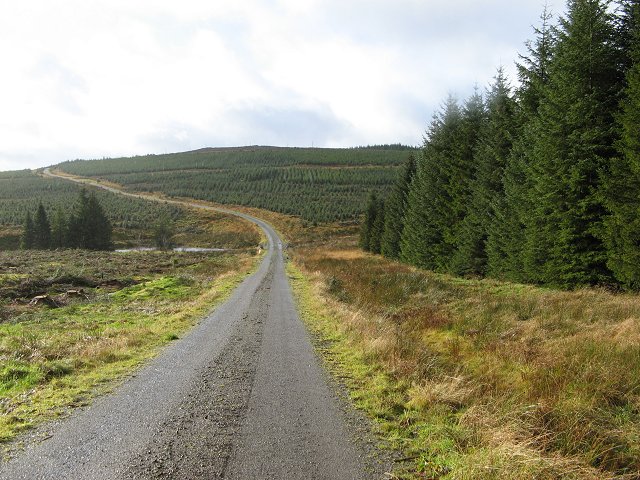
Milestone Wood is a picturesque forest located in Dumfriesshire, Scotland. Covering an area of approximately 500 hectares, the wood is known for its scenic beauty and diverse range of flora and fauna. It is a popular destination for nature enthusiasts, hikers, and wildlife photographers.

The wood is primarily composed of native deciduous trees, including oak, birch, and beech, which provide a stunning display of colors during the autumn season. The forest floor is carpeted with a variety of wildflowers, ferns, and mosses, creating a vibrant and enchanting atmosphere.

Milestone Wood is home to a rich and diverse range of wildlife. Visitors may spot red squirrels, roe deer, and an array of bird species, including woodpeckers, owls, and various songbirds. The wood also serves as a habitat for several protected species, such as the pine marten and red kite.

There are numerous walking trails and paths throughout the wood, allowing visitors to explore its beauty at their own pace. These trails provide stunning views of the surrounding countryside and are suitable for all levels of fitness. There are also picnic areas and rest spots throughout the wood, providing opportunities for visitors to relax and enjoy the serenity of the surroundings.

Milestone Wood is easily accessible by car, with ample parking facilities available. It is a perfect destination for those seeking a peaceful retreat in nature, offering a unique blend of tranquility, natural beauty, and wildlife encounters.

If you have any feedback on the listing, please let us know in the comments section below.

Milestone Wood Images

Images are sourced within 2km of 55.328805/-3.1392144 or Grid Reference NT2704. Thanks to Geograph Open Source API. All images are credited.

Craik Muir The Roman road over Craik Cross runs along the vegetation boundary between the currently open ground and the young trees. It is a grassy track here.
Craik Muir
The Roman road over Craik Cross runs along the vegetation boundary between the currently open ground and the young trees. It is a grassy track here.
The Shank Somewhere near here the road to Aberlosk ran over the moors. It's lost now, to forestry, and Aberlosk is now called Old Aberlosk and is a ruin.  
This was once sheep country, but is now one of the biggest forest plantations in Britain, rivaling England's Kielder Forest. Unlike Kielder, there is minimal tourist development in Craik Forest.
The Shank
Somewhere near here the road to Aberlosk ran over the moors. It's lost now, to forestry, and Aberlosk is now called Old Aberlosk and is a ruin. This was once sheep country, but is now one of the biggest forest plantations in Britain, rivaling England's Kielder Forest. Unlike Kielder, there is minimal tourist development in Craik Forest.
Felled area, The Shank
Across a dull and bitter land "View" over the Aberlosk Burn to more trees in the acid vastness of Craik Forest.
Sadly this prime site for a wind power station will never be used, due to the requirements of the Eskdalemuir seismological station.
Across a dull and bitter land
"View" over the Aberlosk Burn to more trees in the acid vastness of Craik Forest. Sadly this prime site for a wind power station will never be used, due to the requirements of the Eskdalemuir seismological station.
Old Aberlosk Just Aberlosk on the Popular Edition map. Now just a ruin. One of its fields survived the sitka.
This would have been a shepherd's house in the sheep days.
Old Aberlosk
Just Aberlosk on the Popular Edition map. Now just a ruin. One of its fields survived the sitka. This would have been a shepherd's house in the sheep days.
Stell Hill Felled area on a small hill.
Stell Hill
Felled area on a small hill.
Stell Hill From the east. The next generation of trees is well established.
Stell Hill
From the east. The next generation of trees is well established.
Lime Knowe A wall of spruce.  Now that the trees to the south of the road have been felled, these trees will feel the full force of the wind for the first time. I expect there will soon be areas of windthrow here.
Lime Knowe
A wall of spruce. Now that the trees to the south of the road have been felled, these trees will feel the full force of the wind for the first time. I expect there will soon be areas of windthrow here.
Ditch, Lime Knowe This ditch is so big, it made it on to the Ordnance Survey map. Newly felled area by the Langshaw Burn.
Ditch, Lime Knowe
This ditch is so big, it made it on to the Ordnance Survey map. Newly felled area by the Langshaw Burn.
Felled area Recent felling enabled me to get into this square. More of the vastness of Craik. Between Mid Knowe and Lime Knowe.
Felled area
Recent felling enabled me to get into this square. More of the vastness of Craik. Between Mid Knowe and Lime Knowe.
Clear fell in the Eskdalemuir Forest
Aberlosk There are several houses deep in Craik Forest, remnants of the sheep farming days before the coming of the Sitka. 
The ride on the left carries 11kV power lines up to Langshawburn.
Aberlosk
There are several houses deep in Craik Forest, remnants of the sheep farming days before the coming of the Sitka. The ride on the left carries 11kV power lines up to Langshawburn.
Archie Grain View of the burn from a rather battered looking concrete bridge upstream of the site of Nether Langshawburn.
Archie Grain
View of the burn from a rather battered looking concrete bridge upstream of the site of Nether Langshawburn.
Forest road on the flanks of Lamblair Knowe There has been little traffic recently along this road, self seeded trees are encroaching from the sides.
Forest road on the flanks of Lamblair Knowe
There has been little traffic recently along this road, self seeded trees are encroaching from the sides.
Forest, Lamblair Knowe A short struggle from the road which runs along the gridline and I emerged into a clearing, a rare break from continuous Sitka spruce due to waterlogged ground. An empty Tully tube speaks of a half hearted effort to plant something else. There is a broadleafed tree out of sight to the right.  There is a noticeable difference between this part of Craik Forest, privately managed, and the state owned forest on Roxburghshire side of Craik Cross Hill.
Forest, Lamblair Knowe
A short struggle from the road which runs along the gridline and I emerged into a clearing, a rare break from continuous Sitka spruce due to waterlogged ground. An empty Tully tube speaks of a half hearted effort to plant something else. There is a broadleafed tree out of sight to the right. There is a noticeable difference between this part of Craik Forest, privately managed, and the state owned forest on Roxburghshire side of Craik Cross Hill.
Road end, Mid Moss The end of the forest road. Amazingly there is an interpretation board here, and a continuing path to Craik Cross Hill and the Forestry Commission's sector of Craik Forest. It is unusual to be able to travel easily from one owners block of forest to another, no one has any need to build an expensive road to someone else's land.  Travel off road is difficult and arduous on the few rides, and impossible through the trees.
Road end, Mid Moss
The end of the forest road. Amazingly there is an interpretation board here, and a continuing path to Craik Cross Hill and the Forestry Commission's sector of Craik Forest. It is unusual to be able to travel easily from one owners block of forest to another, no one has any need to build an expensive road to someone else's land. Travel off road is difficult and arduous on the few rides, and impossible through the trees.
Forest road by Yellow Sike Self seeded trees are closing in on the little used road up to the Post Office Knowe woodlands.
Forest road by Yellow Sike
Self seeded trees are closing in on the little used road up to the Post Office Knowe woodlands.
View down the Archie Grain Some relief from the trees. A marshy strip along Archie Grain.
View down the Archie Grain
Some relief from the trees. A marshy strip along Archie Grain.
Show me another place!

Milestone Wood is located at Grid Ref: NT2704 (Lat: 55.328805, Lng: -3.1392144)

Unitary Authority: Dumfries and Galloway

Police Authority: Dumfries and Galloway

What 3 Words

///reefs.gentle.overtime. Near Ettrick, Scottish Borders

Related Wikis

Eskdalemuir Observatory

The Eskdalemuir Observatory is a UK national environmental observatory located near Eskdalemuir, Dumfries and Galloway, Scotland. Along with Lerwick and...

Kagyu Samye Ling Monastery and Tibetan Centre

Kagyu Samye Ling Monastery and Tibetan Centre is a Tibetan Buddhist complex associated with the Karma Kagyu school located at Eskdalemuir, Scotland....

Eskdalemuir Forest

Eskdalemuir Forest is a forest north of Eskdalemuir, Dumfries and Galloway, in southern Scotland. It was created as a private enterprise by the Economic...

Eskdalemuir

Eskdalemuir is a civil parish and small village in Dumfries and Galloway, Scotland, with a population of 265. It is around 10 miles (16 km) north-west...

Holm, Inverness

Holm is a small residential area in the south of the city of Inverness, Scotland. The area lies east of the River Ness. The most prominent structure in...

Craik, Scottish Borders

Craik is a hamlet in Craik Forest, by the Airhouse Burn in the Scottish Borders area of Scotland, close to Roberton, Scottish Borders (grid reference NT348084...

Loupin Stanes

The Loupin Stanes (grid reference NY25709663) is a stone circle near Eskdalemuir, Dumfries and Galloway. Oval in shape, it consists of twelve stones set...

Ettrick Pen

Ettrick Pen is a hill in the Ettrick Hills range, part of the Southern Uplands of Scotland. A remote peak, It lies southwest of the village of Ettrick...

Have you been to Milestone Wood?

Leave your review of Milestone Wood below (or comments, questions and feedback).