Castletown

Settlement in Durham

England

Castletown

Hylton Castle, Sunderland 18th Century Gatehouse / Tower 

<span class="nowrap"><a title="https://en.wikipedia.org/wiki/Hylton_Castle" rel="nofollow ugc noopener" href="https://en.wikipedia.org/wiki/Hylton_Castle">Link</a><img style="margin-left:2px;" alt="External link" title="External link - shift click to open in new window" src="https://s1.geograph.org.uk/img/external.png" width="10" height="10"/></span>
Hylton Castle, Sunderland Credit: Brian Deegan

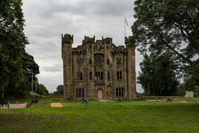
Castletown is a small village located in County Durham, England. It is situated about 5 miles west of the city of Sunderland and lies on the southern bank of the River Wear. The village takes its name from the nearby Hylton Castle, a medieval fortress that has been a prominent landmark in the area for centuries.

Castletown is a primarily residential area, with a mix of housing types ranging from traditional terraced houses to newer developments. The village offers a peaceful and picturesque setting, surrounded by green spaces and parks. The nearby Herrington Country Park provides ample opportunities for outdoor activities, including walking, cycling, and picnicking.

The village has a strong sense of community and is home to several local amenities. These include a primary school, a community center, a library, and a small selection of shops and services. Residents also benefit from good transportation links, with regular bus services connecting Castletown to neighboring towns and cities.

For those seeking cultural and historical experiences, Castletown offers easy access to Sunderland's attractions. The city boasts a rich industrial heritage, with museums such as the Sunderland Museum and Winter Gardens showcasing the region's history. Additionally, the nearby coast offers beautiful beaches and scenic coastal walks.

In summary, Castletown is a charming village in County Durham, offering a peaceful residential setting with access to a range of amenities and nearby attractions. Its proximity to Sunderland provides residents with the best of both worlds – a tranquil village lifestyle with urban conveniences close by.

If you have any feedback on the listing, please let us know in the comments section below.

Castletown Images

Images are sourced within 2km of 54.916654/-1.451615 or Grid Reference NZ3558. Thanks to Geograph Open Source API. All images are credited.

Hylton Castle, Sunderland 18th Century Gatehouse / Tower 

<span class="nowrap"><a title="https://en.wikipedia.org/wiki/Hylton_Castle" rel="nofollow ugc noopener" href="https://en.wikipedia.org/wiki/Hylton_Castle">Link</a><img style="margin-left:2px;" alt="External link" title="External link - shift click to open in new window" src="https://s1.geograph.org.uk/img/external.png" width="10" height="10"/></span>
Hylton Castle, Sunderland
18th Century Gatehouse / Tower LinkExternal link
Northern Spire Bridge Two span cable-stayed bridge across the river Wear, constructed 2015 - 2018. This new crossing upstream of the Queen Alexandra and Wearmouth bridges was required to reduce traffic congestion in the city.
Northern Spire Bridge
Two span cable-stayed bridge across the river Wear, constructed 2015 - 2018. This new crossing upstream of the Queen Alexandra and Wearmouth bridges was required to reduce traffic congestion in the city.
Path under the Metro line at South Hylton
Looking down the line, South Hylton View from the front of the Metro.
Looking down the line, South Hylton
View from the front of the Metro.
River Wear near South Hylton A collection of tyres in the mudbank of the tidal river.
River Wear near South Hylton
A collection of tyres in the mudbank of the tidal river.
Remains of barge on the River Wear I'm informed that this is the remains of Wear Hopper #36, converted to a lifting craft and used to place mooring buoys and lift dock gates.
Remains of barge on the River Wear
I'm informed that this is the remains of Wear Hopper #36, converted to a lifting craft and used to place mooring buoys and lift dock gates.
River Wear at Stony Heugh Scene at the majestic curve of a meander in the River Wear before it reaches the outskirts of Sunderland.
The Weardale Way follows the southern bank in woods, before passing in front of the photographed Garden House, and onto the A19 viaduct.
River Wear at Stony Heugh
Scene at the majestic curve of a meander in the River Wear before it reaches the outskirts of Sunderland. The Weardale Way follows the southern bank in woods, before passing in front of the photographed Garden House, and onto the A19 viaduct.
Hylton Viaduct Takes the A19 high across the River Wear on the outskirts of Sunderland.  Pedestrians using the footpath are in for an uncomfortable experience - a long drop on one side, and three lanes of traffic at breakneck speed on the other.
Hylton Viaduct
Takes the A19 high across the River Wear on the outskirts of Sunderland. Pedestrians using the footpath are in for an uncomfortable experience - a long drop on one side, and three lanes of traffic at breakneck speed on the other.
Access descending towards Ferryboat Lane
Entrance to Grundfos, North Hylton Entrance off Ferryboat Lane
Entrance to Grundfos, North Hylton
Entrance off Ferryboat Lane
River Wear at North Hylton looking Upstream A rather murky scene, endorsed by the soft mudbanks - rich in nutrients and other unmentionable items.
Rotting jetty posts add to the rather desolate surroundings of gradual decay.
River Wear at North Hylton looking Upstream
A rather murky scene, endorsed by the soft mudbanks - rich in nutrients and other unmentionable items. Rotting jetty posts add to the rather desolate surroundings of gradual decay.
River Wear at North Hylton looking Downstream A rather murky scene, endorsed by the soft mudbanks - rich in nutrients and other unmentionable items.
Rotting jetty posts add to the rather desolate surroundings of gradual decay.
River Wear at North Hylton looking Downstream
A rather murky scene, endorsed by the soft mudbanks - rich in nutrients and other unmentionable items. Rotting jetty posts add to the rather desolate surroundings of gradual decay.
Colima Avenue
Colima Avenue
Northern Spire Bridge The Northern Spire is a road bridge across the River Wear in Sunderland.  As well as lanes for traffic, the Northern Spire also has paths for pedestrians and cyclists.

The bridge is a two-span cable-stayed structure supported by a central A-frame.  Construction began in 2015 and the bridge opened in August 2018.

More information about the Northern Spire can be found on Sunderland City Council's website: <span class="nowrap"><a title="https://www.sunderland.gov.uk/article/14608/New-Wear-Crossing-" rel="nofollow ugc noopener" href="https://www.sunderland.gov.uk/article/14608/New-Wear-Crossing-">Link</a><img style="margin-left:2px;" alt="External link" title="External link - shift click to open in new window" src="https://s1.geograph.org.uk/img/external.png" width="10" height="10"/></span>
Northern Spire Bridge
The Northern Spire is a road bridge across the River Wear in Sunderland. As well as lanes for traffic, the Northern Spire also has paths for pedestrians and cyclists. The bridge is a two-span cable-stayed structure supported by a central A-frame. Construction began in 2015 and the bridge opened in August 2018. More information about the Northern Spire can be found on Sunderland City Council's website: LinkExternal link
Footpath leading off Timber Beach Road Heads down and then follows the northern bank of the River Wear
Footpath leading off Timber Beach Road
Heads down and then follows the northern bank of the River Wear
Crossing the Northern Spire Bridge from the South The Northern Spire is a road bridge across the River Wear in Sunderland.  As well as lanes for traffic, the Northern Spire also has paths for pedestrians and cyclists.

The bridge is a two-span cable-stayed structure supported by a central A-frame.  Construction began in 2015 and the bridge opened in August 2018.

More information about the Northern Spire can be found on Sunderland City Council's website: <span class="nowrap"><a title="https://www.sunderland.gov.uk/article/14608/New-Wear-Crossing-" rel="nofollow ugc noopener" href="https://www.sunderland.gov.uk/article/14608/New-Wear-Crossing-">Link</a><img style="margin-left:2px;" alt="External link" title="External link - shift click to open in new window" src="https://s1.geograph.org.uk/img/external.png" width="10" height="10"/></span>
Crossing the Northern Spire Bridge from the South
The Northern Spire is a road bridge across the River Wear in Sunderland. As well as lanes for traffic, the Northern Spire also has paths for pedestrians and cyclists. The bridge is a two-span cable-stayed structure supported by a central A-frame. Construction began in 2015 and the bridge opened in August 2018. More information about the Northern Spire can be found on Sunderland City Council's website: LinkExternal link
The Weardale Way passing beneath Hylton Bridge The bridge carrying the A19 dual carriageway was completed in 1974 <span class="nowrap"><a title="https://www.bridgesonthetyne.co.uk/hylton.html" rel="nofollow ugc noopener" href="https://www.bridgesonthetyne.co.uk/hylton.html">Link</a><img style="margin-left:2px;" alt="External link" title="External link - shift click to open in new window" src="https://s1.geograph.org.uk/img/external.png" width="10" height="10"/></span>
The Weardale Way passing beneath Hylton Bridge
The bridge carrying the A19 dual carriageway was completed in 1974 LinkExternal link
On the footpath crossing Hylton Bridge Our route from the Weardale Way to accommodation at the Travelodge on the other side of the river involves facing three lanes of rush hour traffic on the A19.
On the footpath crossing Hylton Bridge
Our route from the Weardale Way to accommodation at the Travelodge on the other side of the river involves facing three lanes of rush hour traffic on the A19.
Show me another place!

Castletown is located at Grid Ref: NZ3558 (Lat: 54.916654, Lng: -1.451615)

Unitary Authority: Sunderland

Police Authority: Northumbria

What 3 Words

///budget.rents.secret. Near The Boldons, Tyne & Wear

Related Wikis

North Hylton

North Hylton is a suburb of Sunderland, Tyne and Wear, in northeast England. It is on the north bank of River Wear opposite South Hylton. Hylton Castle...

Castletown, Sunderland

Castletown is a suburb of Sunderland in Tyne and Wear, England. A former mining community, the Hylton Colliery was located at the east end of the village...

Hylton Castle

Hylton Castle ( HIL-tən) is a stone castle in the North Hylton area of Sunderland, Tyne and Wear, England. Originally built from wood by the Hilton (later...

Hylton Castle (suburb)

Hylton Castle is a suburb of Sunderland, Tyne and Wear, England. It is named after the nearby Hylton Castle. == External links == Sunderland : The Northern...

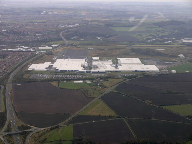
Nissan Motor Manufacturing UK

Nissan Motor Manufacturing (UK) Ltd (NMUK) is a British subsidiary car manufacturing plant in Sunderland. It is owned and operated by the European division...

Claxheugh

Claxheugh ( KLATCH-əf) is an area of South Hylton, Sunderland, Tyne and Wear, England. The area is primarily known for the large, limestone and sandstone...

Chester-le-Street United F.C.

Chester-le-Street United Football Club is a football club based in Chester-le-Street, England. They are currently members of the Northern League Division...

Sunderland West End F.C.

Sunderland West End Football Club is a football club based in Sunderland, Tyne and Wear, England. They are currently members of the Northern League Division...

Nearby Amenities

Located within 500m of 54.916654,-1.451615
Bus Stop
HYLTON CASTLE
Local Ref: S
Naptan AtcoCode: 410000023800
Naptan Bearing: S
Naptan CommonName: HYLTON CASTLE
Naptan Indicator: S
Naptan Landmark: SOUTH OF CASTLETOWN CLUB
Naptan NaptanCode: twrdtmtp
Naptan PlusbusZoneRef: SNDRLND
Naptan Street: CLACTON ROAD
Naptan Verified: no
Source: naptan_import
Lat/Long: 54.9181973/-1.4559456
Bus Stop
CULLERCOATS ROAD-S/B
Local Ref: S
Naptan AtcoCode: 410000023801
Naptan Bearing: S
Naptan CommonName: CULLERCOATS ROAD-S/B
Naptan Indicator: S
Naptan Landmark: OUTSIDE CULLERCOATS SQUARE
Naptan NaptanCode: twrdtmtw
Naptan PlusbusZoneRef: SNDRLND
Naptan Street: CULLERCOATS ROAD
Naptan Verified: no
Source: naptan_import
Lat/Long: 54.918657/-1.4582484
Bus Stop
CRICKLEWOOD ROAD-E/B
Local Ref: E
Naptan AtcoCode: 410000023802
Naptan Bearing: E
Naptan CommonName: CRICKLEWOOD ROAD-E/B
Naptan Indicator: E
Naptan Landmark: OUTSIDE CRAMLINGTON ROAD JUNCTION
Naptan NaptanCode: twrdtmwa
Naptan PlusbusZoneRef: SNDRLND
Naptan Street: CRICKLEWOOD ROAD
Naptan Verified: no
Source: naptan_import
Lat/Long: 54.9190131/-1.4575103
Bus Stop
NORTH HYLTON
Bus: yes
Local Ref: N
Naptan AtcoCode: 410000024192
Naptan Bearing: N
Naptan CommonName: NORTH HYLTON
Naptan Indicator: N
Naptan Landmark: OUTSIDE JUNCTION WITH LABURNUM GROVE
Naptan NaptanCode: twrdwdpa
Naptan PlusbusZoneRef: SNDRLND
Naptan Street: GRANGE ROAD
Naptan Verified: no
Public Transport: platform
Source: naptan_import
Lat/Long: 54.9133835/-1.4506131
Bus Stop
GRANGE ROAD-THOMPSON CRESCENT-E/B
Bus: yes
Local Ref: E
Naptan AtcoCode: 410000024193
Naptan Bearing: E
Naptan CommonName: GRANGE ROAD-THOMPSON CRESCENT-E/B
Naptan Indicator: E
Naptan Landmark: OPPOSITE CASTLETOWN JUNIOR AND INFANTS SCHOOL
Naptan NaptanCode: twrdwdpd
Naptan PlusbusZoneRef: SNDRLND
Naptan Street: GRANGE ROAD
Naptan Verified: no
Public Transport: platform
Source: naptan_import
Lat/Long: 54.9157213/-1.4449652
Bus Stop
HYLTON CASTLE ROAD-ERNWILL AVENUE-N/B
Bus: yes
Local Ref: N
Naptan AtcoCode: 410000024199
Naptan Bearing: N
Naptan CommonName: HYLTON CASTLE ROAD-ERNWILL AVENUE-N/B
Naptan Indicator: N
Naptan Landmark: OUTSIDE ST MARGARET'S HOUSE CHURCH
Naptan NaptanCode: twrdwdpw
Naptan PlusbusZoneRef: SNDRLND
Naptan Street: HYLTON CASTLE ROAD
Naptan Verified: no
Public Transport: platform
Source: naptan_import
Lat/Long: 54.9174717/-1.4465012
Bus Stop
HYLTON CASTLE ROAD-LILLEY GROVE-S/B
Bus: yes
Local Ref: S
Naptan AtcoCode: 410000024579
Naptan Bearing: S
Naptan CommonName: HYLTON CASTLE ROAD-LILLEY GROVE-S/B
Naptan Indicator: S
Naptan Landmark: OPPOSITE CASTLETOWN CEMETERY
Naptan NaptanCode: twrgadtd
Naptan PlusbusZoneRef: SNDRLND
Naptan Street: HYLTON CASTLE ROAD
Naptan Verified: no
Public Transport: platform
Source: naptan_import
Lat/Long: 54.9163133/-1.4466887
Bus Stop
RINGWAY-TOLLERTON DRIVE-E/B
Bus: yes
Local Ref: E
Naptan AtcoCode: 410000024803
Naptan Bearing: E
Naptan CommonName: RINGWAY-TOLLERTON DRIVE-E/B
Naptan Indicator: E
Naptan Landmark: OUTSIDE THE RECREATION GROUND
Naptan NaptanCode: twrgadwm
Naptan PlusbusZoneRef: SNDRLND
Naptan Street: RINGWAY
Naptan Verified: no
Public Transport: platform
Source: naptan_import
Lat/Long: 54.9149282/-1.4504049
Bus Stop
GRANGE ROAD-ST MARGARETS AVENUE-W/B
Bus: yes
Local Ref: W
Naptan AtcoCode: 410000024807
Naptan Bearing: W
Naptan CommonName: GRANGE ROAD-ST MARGARETS AVENUE-W/B
Naptan Indicator: W
Naptan Landmark: OUTSIDE CRICKET GROUND
Naptan NaptanCode: twrgagag
Naptan PlusbusZoneRef: SNDRLND
Naptan Street: GRANGE ROAD
Naptan Verified: no
Public Transport: platform
Shelter: no
Source: naptan_import
Lat/Long: 54.9149435/-1.4478307
Bus Stop
Grange Road
Bus: yes
Departures Board: timetable
Local Ref: E
Naptan AtcoCode: 410000024808
Naptan Bearing: E
Naptan CommonName: GRANGE ROAD-ST MARGARETS AVENUE-E/B
Naptan Indicator: E
Naptan Landmark: OPPOSITE CRICKET GROUND
Naptan NaptanCode: twrgtatd
Naptan PlusbusZoneRef: SNDRLND
Naptan Street: GRANGE ROAD
Naptan Verified: no
Public Transport: platform
Shelter: yes
Source: naptan_import
Lat/Long: 54.9151745/-1.4472347
Bus Stop
HYLTON CASTLE ROAD-CASTLE VIEW-S/B
Bus: yes
Local Ref: S
Naptan AtcoCode: 410000024981
Naptan Bearing: S
Naptan CommonName: HYLTON CASTLE ROAD-CASTLE VIEW-S/B
Naptan Indicator: S
Naptan Landmark: NORTH OF CASTLE VIEW
Naptan NaptanCode: twrgajdw
Naptan PlusbusZoneRef: SNDRLND
Naptan Street: HYLTON CASTLE ROAD
Naptan Verified: no
Public Transport: platform
Source: naptan_import
Lat/Long: 54.9183677/-1.4459117
Bus Stop
GRANGE ROAD-RYDAL MOUNT-NE/B
Bus: yes
Local Ref: NE
Naptan AtcoCode: 410000024982
Naptan Bearing: NE
Naptan CommonName: GRANGE ROAD-RYDAL MOUNT-NE/B
Naptan Indicator: NE
Naptan Landmark: OUTSIDE SURGERY
Naptan NaptanCode: twrgajga
Naptan PlusbusZoneRef: SNDRLND
Naptan Street: GRANGE ROAD
Naptan Verified: no
Public Transport: platform
Source: naptan_import
Lat/Long: 54.9143122/-1.4493057
Bus Stop
RINGWAY-TOLLERTON DRIVE-W/B
Bus: yes
Local Ref: W
Naptan AtcoCode: 410000024991
Naptan Bearing: W
Naptan CommonName: RINGWAY-TOLLERTON DRIVE-W/B
Naptan Indicator: W
Naptan Landmark: OPPOSITE THE RECREATION GROUND
Naptan NaptanCode: twrgajmg
Naptan PlusbusZoneRef: SNDRLND
Naptan Street: RINGWAY
Naptan Verified: no
Public Transport: platform
Source: naptan_import
Lat/Long: 54.9148561/-1.4503591
Bus Stop
RINGWAY-WELWYN CLOSE-W/B
Bus: yes
Local Ref: W
Naptan AtcoCode: 410000024992
Naptan Bearing: W
Naptan CommonName: RINGWAY-WELWYN CLOSE-W/B
Naptan Indicator: W
Naptan Landmark: OUTSIDE THE SUNRISE ENTERPRISE PARK
Naptan NaptanCode: twrgajmj
Naptan PlusbusZoneRef: SNDRLND
Naptan Street: RINGWAY
Naptan Verified: no
Public Transport: platform
Source: naptan_import
Lat/Long: 54.9146489/-1.4542306
Mini Roundabout
Direction: clockwise
Lat/Long: 54.9153214/-1.4465392
Turning Circle
Lat/Long: 54.9167037/-1.4449657
Give Way
Direction: backward
Lat/Long: 54.9189054/-1.45825
Post Box
Brand: Royal Mail
Brand Wikidata: Q638098
Operator: Royal Mail
Operator Wikidata: Q638098
Post Box Type: pillar
Lat/Long: 54.9142553/-1.4492372
Bus Stop
Bus: yes
Public Transport: platform
Shelter: no
Lat/Long: 54.9148352/-1.4514083
Fulford Grange
Place: suburb
Lat/Long: 54.915588/-1.453689
Addr Housenumber: 1
Lat/Long: 54.9156454/-1.4457689
Generator Method: photovoltaic
Generator Output Electricity: yes
Generator Source: solar
Generator Type: solar_photovoltaic_panel
Location: roof
Power: generator
Lat/Long: 54.9155537/-1.4470883
Bus Stop
Bus: yes
Public Transport: platform
Lat/Long: 54.9149001/-1.4521383
Generator Method: photovoltaic
Generator Output Electricity: yes
Generator Source: solar
Generator Type: solar_photovoltaic_panel
Location: roof
Power: generator
Lat/Long: 54.9155479/-1.4470258
The data included in this document is from www.openstreetmap.org. The data is made available under ODbL.

Have you been to Castletown?

Leave your review of Castletown below (or comments, questions and feedback).