Castlemorton

Settlement in Worcestershire Malvern Hills

England

Castlemorton

Castlemorton Common Looking south-west along the south edge of the large common stretching right up to the foot of the Malvern Hills.
Castlemorton Common Credit: Trevor Rickard

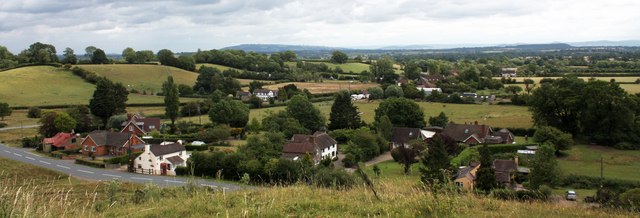
Castlemorton is a small village located in the county of Worcestershire, England. Situated on the eastern slopes of the Malvern Hills, it is nestled amidst picturesque countryside and offers stunning views of the surrounding area. The village lies approximately 9 miles southwest of the city of Worcester.

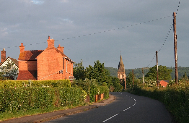
With a population of around 500 residents, Castlemorton retains a tight-knit and close community feel. The village is characterized by its charming traditional cottages and historic buildings, reflecting its long-standing heritage. The parish church, St. Gregory's, stands proudly at the heart of the village and dates back to the 12th century.

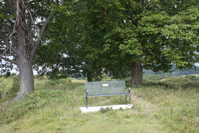
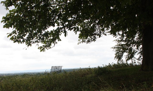
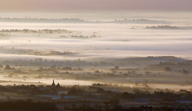
The village is surrounded by beautiful countryside, making it a haven for outdoor enthusiasts. The Malvern Hills, an Area of Outstanding Natural Beauty, provide ample opportunities for hiking, cycling, and horse riding. The nearby Castlemorton Common is a vast expanse of open heathland, offering tranquil walks and the chance to observe diverse wildlife.

Despite its rural location, Castlemorton benefits from good transport links. The B4211 road connects the village to Worcester and the neighboring towns of Malvern and Upton-upon-Severn. The village also has a bus service, providing convenient access to nearby amenities.

In terms of amenities, Castlemorton offers a village hall, providing a venue for community events and activities. There is also a pub, The Plume of Feathers, which serves as a popular gathering spot for locals and visitors alike.

Overall, Castlemorton offers a beautiful and idyllic setting, combining a strong sense of community with easy access to stunning countryside and nearby towns.

If you have any feedback on the listing, please let us know in the comments section below.

Castlemorton Images

Images are sourced within 2km of 52.03354/-2.300713 or Grid Reference SO7937. Thanks to Geograph Open Source API. All images are credited.

Castlemorton Common Looking south-west along the south edge of the large common stretching right up to the foot of the Malvern Hills.
Castlemorton Common
Looking south-west along the south edge of the large common stretching right up to the foot of the Malvern Hills.
Cattle on Castlemorton Common - 2 Looking west with Little Malvern Priory in the background.
Cattle on Castlemorton Common - 2
Looking west with Little Malvern Priory in the background.
Coombegreen The view from Wendy Woodward's seat atop the hillock on Coombegreen Common.
Looking out to the houses on the B4208 and those on Birts Street.
<a href="https://www.geograph.org.uk/photo/2511815">SO7736 : Wendy Woodward's seat, Coombegreen Common</a>
Coombegreen
The view from Wendy Woodward's seat atop the hillock on Coombegreen Common. Looking out to the houses on the B4208 and those on Birts Street. SO7736 : Wendy Woodward's seat, Coombegreen Common
Wendy Woodward's seat, Coombegreen Common The seat is at the front of the hill overlooking the Severn Plain.
Behind are several commemorative trees including one dating back to 1937 for the King's Coronation.
<a href="https://www.geograph.org.uk/photo/2511845">SO7736 : Plaque on Wendy Woodward's seat, Coombe Green</a>
<a href="https://www.geograph.org.uk/photo/2511865">SO7736 : Wendy Woodward's seat, Coombe Green Common</a>
<a href="https://www.geograph.org.uk/photo/2511797">SO7736 : Coombegreen</a>
Wendy Woodward's seat, Coombegreen Common
The seat is at the front of the hill overlooking the Severn Plain. Behind are several commemorative trees including one dating back to 1937 for the King's Coronation. SO7736 : Plaque on Wendy Woodward's seat, Coombe Green SO7736 : Wendy Woodward's seat, Coombe Green Common SO7736 : Coombegreen
Plaque on Wendy Woodward's seat, Coombe Green In loving memory of
Wendy Woodward
Died 3 March 2004 aged 90 years
Enjoy the view as she did
<a href="https://www.geograph.org.uk/photo/2511815">SO7736 : Wendy Woodward's seat, Coombegreen Common</a>
Plaque on Wendy Woodward's seat, Coombe Green
In loving memory of Wendy Woodward Died 3 March 2004 aged 90 years Enjoy the view as she did SO7736 : Wendy Woodward's seat, Coombegreen Common
Wendy Woodward's seat, Coombe Green Common At the front of the hill overlooking the Severn Plain.
<a href="https://www.geograph.org.uk/photo/2511815">SO7736 : Wendy Woodward's seat, Coombegreen Common</a>
Wendy Woodward's seat, Coombe Green Common
At the front of the hill overlooking the Severn Plain. SO7736 : Wendy Woodward's seat, Coombegreen Common
Commemorative Tree, Coombegreen Common One of several trees that appear to be planted on the knoll to commemorate royal occasions.
This one was probably planted for the marriage of William and Katherine in 2011.
Will another appear this year for Her Majesty's Diamond Jubilee?
Ragged Stone Hill in the background.
Commemorative Tree, Coombegreen Common
One of several trees that appear to be planted on the knoll to commemorate royal occasions. This one was probably planted for the marriage of William and Katherine in 2011. Will another appear this year for Her Majesty's Diamond Jubilee? Ragged Stone Hill in the background.
Anthills, Coombe Green Viewed from the knoll on Coombegreen Common.
Much of the common is covered with tightly packed anthills, but this enclosed pasture is less dense.
Anthills, Coombe Green
Viewed from the knoll on Coombegreen Common. Much of the common is covered with tightly packed anthills, but this enclosed pasture is less dense.
Footpath around a rape-field Heading towards Birts Street; Malvern Hills in the distance.
Footpath around a rape-field
Heading towards Birts Street; Malvern Hills in the distance.
Footpath into pasture This public path joins a network of rights-of-way between Birts Street and Rye Street.
Footpath into pasture
This public path joins a network of rights-of-way between Birts Street and Rye Street.
Miller's Court Road Miller's Court and its farm are to the right.
Ragged Stone Hill can be seen between the trees.
Miller's Court Road
Miller's Court and its farm are to the right. Ragged Stone Hill can be seen between the trees.
Red rambling rose Gracing the outer wall of buildings at Miller's Court; also seen in <a href="https://www.geograph.org.uk/photo/3107366">SO7936 : Miller's Court Road</a>.
Red rambling rose
Gracing the outer wall of buildings at Miller's Court; also seen in SO7936 : Miller's Court Road.
Footpath into maize A claustrophobic walk from Miller's Court Road to Castlemorton.
Footpath into maize
A claustrophobic walk from Miller's Court Road to Castlemorton.
Miller's Court Road Looking west towards Birts Street.
Miller's Court Road
Looking west towards Birts Street.
Castlemorton church and November mist Taken from Black Hill on the Malverns just after dawn.
Castlemorton church and November mist
Taken from Black Hill on the Malverns just after dawn.
Castlemorton church with mist over Longdon Marsh Viewed from Black Hill on the Malverns.  Mist follows the route of the River Severn and a large patch smothers the low land of Longdon Marsh.
Castlemorton church with mist over Longdon Marsh
Viewed from Black Hill on the Malverns. Mist follows the route of the River Severn and a large patch smothers the low land of Longdon Marsh.
Approaching Castlemorton Entering this straggling Worcestershire village from the east.
Approaching Castlemorton
Entering this straggling Worcestershire village from the east.
Castlemorton's old farm buildings, 1 Part of Castle Farm.
Castlemorton's old farm buildings, 1
Part of Castle Farm.
Show me another place!

Castlemorton is located at Grid Ref: SO7937 (Lat: 52.03354, Lng: -2.300713)

Administrative County: Worcestershire

District: Malvern Hills

Police Authority: West Mercia

What 3 Words

///grazed.anguished.newsreel. Near Upton upon Severn, Worcestershire

Nearby Locations

Castlemorton Castlemorton

Related Wikis

Castlemorton

Castlemorton is a village and civil parish close to Malvern in the Malvern Hills District in the county of Worcestershire, England. It consists of a...

Hollybed Farm Meadows

Hollybed Farm Meadows is nature reserve of the Worcestershire Wildlife Trust, about 1 mile (1.6 km) west of the village of Castlemorton, in Worcestershire...

Birts Street

Birts Street is a village in Worcestershire, England.

Birtsmorton

Birtsmorton is a village and civil parish in the Malvern Hills of Worcestershire, England, which at the 2021 census had a population of 257. It is in...

Birtsmorton Court

Birtsmorton Court is a Grade I listed fortified medieval moated manor house near Malvern in Worcestershire, in the former woodlands of Malvern Chase.It...

Castlemorton Common Festival

The Castlemorton Common Festival was a week-long free festival and rave held in the Malvern Hills near Malvern, Worcestershire, England between 22 and...

Rye Cross

Rye Cross is a hamlet in south-west Worcestershire 1 mile west of Castlemorton, 0.5 miles east of Berrow and 1 mile south of Hollybush, near the borders...

Welland, Worcestershire

Welland is a village and civil parish in the administrative district of Malvern Hills in the county of Worcestershire, England. It has a combined parish...

Nearby Amenities

Located within 500m of 52.03354,-2.300713
Castlemorton
Place: village
Wikidata: Q1830583
Lat/Long: 52.033971/-2.3005267
Church
Naptan AtcoCode: 2000G063400
Naptan Bearing: NE
Naptan BusStopType: CUS
Naptan CommonName: Church
Naptan Crossing: Church Road
Naptan Indicator: Opp
Naptan Landmark: Church
Naptan NaptanCode: wocdjpad
Naptan Street: High Street
Naptan Verified: no
Source: naptan_import
Lat/Long: 52.0334866/-2.3008193
Bus Stop
Primary School
Naptan AtcoCode: 2000G645001
Naptan Bearing: NE
Naptan CommonName: Primary School
Naptan Indicator: Adj
Naptan Landmark: Primary School
Naptan NaptanCode: wocdwjap
Naptan Street: Village Road
Naptan Verified: no
Source: naptan_import
Lat/Long: 52.0322884/-2.3017588
Post Box
Fixme: ref is conjectural. Also check box hasn't been nicked.
Post Box Type: wall
Ref: WR13 70
Lat/Long: 52.0328499/-2.3010963
Roughcast
Power: pole
Transformer: distribution
Voltage Primary: 11000
Lat/Long: 52.0350167/-2.3051112
Location Transition: yes
Power: pole
Lat/Long: 52.0361234/-2.3047733
Power: pole
Lat/Long: 52.0359609/-2.3036568
Power: pole
Lat/Long: 52.0357852/-2.3023908
Power: pole
Lat/Long: 52.0354271/-2.3008391
Castlemorton
Power: pole
Transformer: distribution
Voltage Primary: 11000
Lat/Long: 52.0339408/-2.2995476
Power: pole
Lat/Long: 52.0350604/-2.299258
Castlemorton - Padmount
Power: transformer
Transformer: distribution
Voltage Primary: 11000
Lat/Long: 52.0333938/-2.2989656
Castlemorton Sewage Station
Power: pole
Transformer: distribution
Voltage Primary: 11000
Lat/Long: 52.03165/-2.3020823
Power: pole
Lat/Long: 52.0320347/-2.3016777
Castlemorton School
Power: pole
Transformer: distribution
Voltage Primary: 11000
Lat/Long: 52.0325259/-2.3011704
Power: pole
Lat/Long: 52.032439/-2.3002209
Power: pole
Lat/Long: 52.0325073/-2.2988503
Power: pole
Lat/Long: 52.0325382/-2.2982025
Location Transition: yes
Power: pole
Lat/Long: 52.0330646/-2.2980402
Power: pole
Lat/Long: 52.0334755/-2.2979216
Power: pole
Lat/Long: 52.0340757/-2.2977452
Power: pole
Lat/Long: 52.0346879/-2.2975548
Power: pole
Lat/Long: 52.0345175/-2.2965174
Power: pole
Lat/Long: 52.0342997/-2.2952011
Power: pole
Lat/Long: 52.0340889/-2.2938707
Castlemorton Tump
Information: board
Tourism: information
Lat/Long: 52.0324359/-2.3012438
Barrier: swing_gate
Lat/Long: 52.0325174/-2.3013042
The data included in this document is from www.openstreetmap.org. The data is made available under ODbL.

Have you been to Castlemorton?

Leave your review of Castlemorton below (or comments, questions and feedback).