Castellmartin

Settlement in Pembrokeshire

Wales

Castellmartin

Ordnance Survey Flush Bracket (G5105) This OS Flush Bracket can be found on the NT building at Gupton Farm. It marks a point 37.158m above mean sea level.
Ordnance Survey Flush Bracket (G5105) Credit: Adrian Dust

Castellmartin is a small village located in the county of Pembrokeshire, Wales. It is situated approximately 7 miles north of the town of Pembroke and lies within the Pembrokeshire Coast National Park. The village is nestled in a picturesque rural setting, surrounded by rolling hills and farmland.

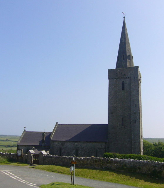
One of the notable features of Castellmartin is its historic church, St. Martin's Church. Dating back to the 13th century, the church exhibits stunning architectural details and serves as a reminder of the village's rich heritage. The village itself is relatively small, with a population of around 200 residents.

The surrounding area offers numerous opportunities for outdoor activities, with several walking trails and nature reserves nearby. One of the popular attractions is the Castellmartin Riding Centre, which provides horse riding lessons and scenic rides through the countryside.

In terms of amenities, the village has a local pub, The Castle Inn, which offers a warm and friendly atmosphere for both residents and visitors. There are also a few small businesses, including a village shop and a post office, catering to the everyday needs of the community.

Overall, Castellmartin offers a peaceful and idyllic lifestyle, with its charming rural setting, historic church, and access to outdoor activities. It is a perfect destination for those seeking a tranquil retreat or a base to explore the natural beauty of Pembrokeshire.

If you have any feedback on the listing, please let us know in the comments section below.

Castellmartin Images

Images are sourced within 2km of 51.646031/-5.018573 or Grid Reference SR9198. Thanks to Geograph Open Source API. All images are credited.

Ordnance Survey Flush Bracket (G5105) This OS Flush Bracket can be found on the NT building at Gupton Farm. It marks a point 37.158m above mean sea level.
Ordnance Survey Flush Bracket (G5105)
This OS Flush Bracket can be found on the NT building at Gupton Farm. It marks a point 37.158m above mean sea level.
Entrance to Gupton Farm
Pembrokeshire Coast Path at Castlemartin Range The path is open here at all times - but you are warned about the possibility of sudden noises, smoke or military troops, and do NOT touch suspicious objects!
The path runs between the B4319 and Brownslade Burrows
Pembrokeshire Coast Path at Castlemartin Range
The path is open here at all times - but you are warned about the possibility of sudden noises, smoke or military troops, and do NOT touch suspicious objects! The path runs between the B4319 and Brownslade Burrows
Entrance to National Trust campsite
Gupton Farm Arable land north of the B4319 to the west of Castlemartin.
Gupton Farm
Arable land north of the B4319 to the west of Castlemartin.
Farm Sign The track leading to Gupton Farm.
Farm Sign
The track leading to Gupton Farm.
Military checkpoint One of many checkpoints on the Castlemartin Range.
Military checkpoint
One of many checkpoints on the Castlemartin Range.
Fields near Gupton Farm The view across the fields shows the Angle Oil refinery in the distance.
Fields near Gupton Farm
The view across the fields shows the Angle Oil refinery in the distance.
Frainslake Mill The mill pond is now flooded and the mill submerged.
Frainslake Mill
The mill pond is now flooded and the mill submerged.
Frainslake Mill The mill was flooded by the creation of Frains Lake.
Frainslake Mill
The mill was flooded by the creation of Frains Lake.
Bush by the B4319
Bush by the B4319
Castlemartin Range Trail and Pembrokeshire Coastal Path by the B4319 A 5.5 mile long trail along the edge of Castlemartin Ranges, between near Bosherton and Freshwater West
The Logo is a tank <a href="https://www.geograph.org.uk/photo/3806100">SR9596 : Castlemartin Trail Logo</a>
Map: <span class="nowrap"><a title="http://enjoy.pcnpa.org.uk/sitefiles/img/page_content/documents/files/castlemartin_range_trail.pdf" rel="nofollow ugc noopener" href="http://enjoy.pcnpa.org.uk/sitefiles/img/page_content/documents/files/castlemartin_range_trail.pdf">Link</a><img style="margin-left:2px;" alt="External link" title="External link - shift click to open in new window" src="https://s1.geograph.org.uk/img/external.png" width="10" height="10"/></span>
Castlemartin Range Trail and Pembrokeshire Coastal Path by the B4319
A 5.5 mile long trail along the edge of Castlemartin Ranges, between near Bosherton and Freshwater West The Logo is a tank SR9596 : Castlemartin Trail Logo Map: LinkExternal link
Cattle, Gupton Farm
Cattle, Gupton Farm
An entrance to Castlemartin Ranges The Castlemartin Army Training Area was established in 1939 and covers 2,390 hectares of Pembrokeshire. It is owned by the Ministry of Defence (MoD) it is located within the Pembrokeshire Coast National Park.
The ranges are active for 44 weeks of the year and when in use can include a coastal exclusion zone of some 12 nautical miles off the coast, or as little as 3 nautical miles depending on weapons systems/munitions being used.
An entrance to Castlemartin Ranges
The Castlemartin Army Training Area was established in 1939 and covers 2,390 hectares of Pembrokeshire. It is owned by the Ministry of Defence (MoD) it is located within the Pembrokeshire Coast National Park. The ranges are active for 44 weeks of the year and when in use can include a coastal exclusion zone of some 12 nautical miles off the coast, or as little as 3 nautical miles depending on weapons systems/munitions being used.
Castlemartin Ranges The Castlemartin Army Training Area was established in 1939 and covers 2,390 hectares of Pembrokeshire. It is owned by the Ministry of Defence (MoD) it is located within the Pembrokeshire Coast National Park.
The ranges are active for 44 weeks of the year and when in use can include a coastal exclusion zone of some 12 nautical miles off the coast, or as little as 3 nautical miles depending on weapons systems/munitions being used.
Castlemartin Ranges
The Castlemartin Army Training Area was established in 1939 and covers 2,390 hectares of Pembrokeshire. It is owned by the Ministry of Defence (MoD) it is located within the Pembrokeshire Coast National Park. The ranges are active for 44 weeks of the year and when in use can include a coastal exclusion zone of some 12 nautical miles off the coast, or as little as 3 nautical miles depending on weapons systems/munitions being used.
King's Mill Farm and drive
Castlemartin Pound Now providing a substantial roundabout.
Castlemartin Pound
Now providing a substantial roundabout.
Inside Castlemartin Pound
Show me another place!

Castellmartin is located at Grid Ref: SR9198 (Lat: 51.646031, Lng: -5.018573)

Unitary Authority: Pembrokeshire

Police Authority: Dyfed Powys

Also known as: Castlemartin

What 3 Words

///throat.approach.paddlers. Near Castlemartin, Pembrokeshire

Nearby Locations

Castlemartin Castellmartin

Related Wikis

Church of St Michael and All Angels, Castlemartin, Pembrokeshire

The Church of St Michael and All Angels, Castlemartin, Pembrokeshire, Wales is a redundant church dating from the 13th century. A Grade I listed building...

Castlemartin, Pembrokeshire

Castlemartin (Welsh: Castell Martin) is a village and parish in the community of Stackpole and Castlemartin, Pembrokeshire, Wales, in the Pembrokeshire...

Warren, Pembrokeshire

Warren is an ancient parish in the community of Stackpole and Castlemartin, in the most southerly part of Pembrokeshire, Wales. Its northern edge is 5...

Castlemartin Corse

Castlemartin Corse is a Site of Special Scientific Interest (or SSSI) in Pembrokeshire, South Wales. It has been designated as a Site of Special Scientific...

Nearby Amenities

Located within 500m of 51.646031,-5.018573
Place Of Worship
Church of St. Michael
Religion: christian
Wikidata: Q17742327
Lat/Long: 51.6497938/-5.021561
Give Way
Direction: forward
Lat/Long: 51.6448679/-5.0141694
Give Way
Direction: forward
Lat/Long: 51.6448927/-5.0143277
Castlemartin
Name Cy: Castellmartin
Place: village
Population: 147
Wikidata: Q5050548
Wikipedia: en:Castlemartin, Pembrokeshire
Lat/Long: 51.6448085/-5.0152236
Give Way
Direction: forward
Lat/Long: 51.6449065/-5.0140804
Give Way
Direction: forward
Lat/Long: 51.6447515/-5.0146397
Give Way
Direction: backward
Lat/Long: 51.6451104/-5.0141323
Give Way
Direction: backward
Lat/Long: 51.6450055/-5.0144501
Direction: 215
Generator Method: photovoltaic
Generator Output Electricity: yes
Generator Solar Modules: 14
Generator Source: solar
Generator Type: solar_photovoltaic_panel
Location: roof
Power: generator
Lat/Long: 51.6451526/-5.0158006
The data included in this document is from www.openstreetmap.org. The data is made available under ODbL.

Have you been to Castellmartin?

Leave your review of Castellmartin below (or comments, questions and feedback).