Avenue Wood

Wood, Forest in Kirkcudbrightshire

Scotland

Avenue Wood

Whinneyhill Farm North of New Abbey
Whinneyhill Farm Credit: Eirian Evans

Avenue Wood is a dense forest located in Kirkcudbrightshire, Scotland. Stretching over an area of approximately 100 acres, it is a popular destination for nature enthusiasts and outdoor adventurers. The woodland is characterized by its tall and mature trees, primarily consisting of oak, beech, and birch species, which create a picturesque and serene atmosphere.

The forest features a network of well-maintained trails that wind through its enchanting landscape, offering visitors the opportunity to explore its beauty on foot or by bicycle. These trails are suitable for all ages and fitness levels, making Avenue Wood an ideal destination for families and individuals seeking a peaceful escape from the hustle and bustle of city life.

The forest is home to a diverse range of flora and fauna, providing a habitat for various bird species, including woodpeckers and owls. Additionally, small mammals such as squirrels and rabbits can often be spotted darting among the trees.

Avenue Wood is renowned for its vibrant display of wildflowers during the spring and summer months, attracting nature enthusiasts and photographers alike. The forest also boasts a tranquil stream that meanders through its heart, adding to its natural beauty.

Visitors to Avenue Wood can take advantage of the designated picnic areas and benches scattered throughout the forest, allowing for leisurely breaks and opportunities to immerse oneself in the peaceful surroundings. Overall, Avenue Wood is a hidden gem in Kirkcudbrightshire, offering a captivating and tranquil woodland experience for all who visit.

If you have any feedback on the listing, please let us know in the comments section below.

Avenue Wood Images

Images are sourced within 2km of 55.020488/-3.6348995 or Grid Reference NX9570. Thanks to Geograph Open Source API. All images are credited.

Whinneyhill Farm North of New Abbey
Whinneyhill Farm
North of New Abbey
Rainbow over Kirkconnell Flow March 2022 This raised bog was formerly stocked with mature pines.  Now managed by SNH, who are endeavouring to restore it, by blocking drains, and controlling woody re-growth.  Pine and birch seedlings continue to emerge, 2 decades later.
Rainbow over Kirkconnell Flow March 2022
This raised bog was formerly stocked with mature pines. Now managed by SNH, who are endeavouring to restore it, by blocking drains, and controlling woody re-growth. Pine and birch seedlings continue to emerge, 2 decades later.
Lodge near the road to Mabie Forest
Clearfelling at Kirkconnel Flow An area of clearfelling at Kirkconnel Flow.
Clearfelling at Kirkconnel Flow
An area of clearfelling at Kirkconnel Flow.
Cattle and sheep in pasture Near Flatts of Cargen.
Close to the River Nith.
Cattle and sheep in pasture
Near Flatts of Cargen. Close to the River Nith.
A710 towards Islesteps
A710 New Abbey Road
A710 New Abbey Road
Dumfries Model Flying Club field
Forestry road in Mabie Forest
A710 near Mabie
A710 near Mabie
Whinnyhill View Looking along the A710 at Whinnyhill on a bright mid-September morning.
Whinnyhill View
Looking along the A710 at Whinnyhill on a bright mid-September morning.
The River Nith from the air Woodcroft Farm and Kirkconnell Flow nature reserve <span class="nowrap"><a title="https://www.visitscotland.com/info/see-do/kirkconnell-flow-nature-reserve-p334051" rel="nofollow ugc noopener" href="https://www.visitscotland.com/info/see-do/kirkconnell-flow-nature-reserve-p334051">Link</a><img style="margin-left:2px;" alt="External link" title="External link - shift click to open in new window" src="https://s1.geograph.org.uk/img/external.png" width="10" height="10"/></span> are in the foreground.
The River Nith from the air
Woodcroft Farm and Kirkconnell Flow nature reserve LinkExternal link are in the foreground.
Rough grazing at Auchenfad Rough grazing at Auchenfad with Mabie Forest in the background.
Rough grazing at Auchenfad
Rough grazing at Auchenfad with Mabie Forest in the background.
Greeted by a cow at Woodcroft Farm
Bluebells near Woodcroft Farm
Sheep on Whinny Hill
Field at Whinny Hill
Field at Auchenfad
Field at Auchenfad
Show me another place!

Avenue Wood is located at Grid Ref: NX9570 (Lat: 55.020488, Lng: -3.6348995)

Unitary Authority: Dumfries and Galloway

Police Authority: Dumfries and Galloway

What 3 Words

///appraised.shares.attending. Near Dumfries, Dumfries & Galloway

Nearby Locations

Knock Torr Avenue Wood

Related Wikis

Mabie, Dumfries and Galloway

Mabie is a collection of mountain biking routes located in Dumfries and Galloway, southwest Scotland. The mountain bike routes are part of the 7Stanes...

Pict's Knowe

Pict's Knowe (grid reference NX 9538 7213) is a henge monument in the parish of Troqueer, Dumfries and Galloway. It is one of a small group of henge monuments...
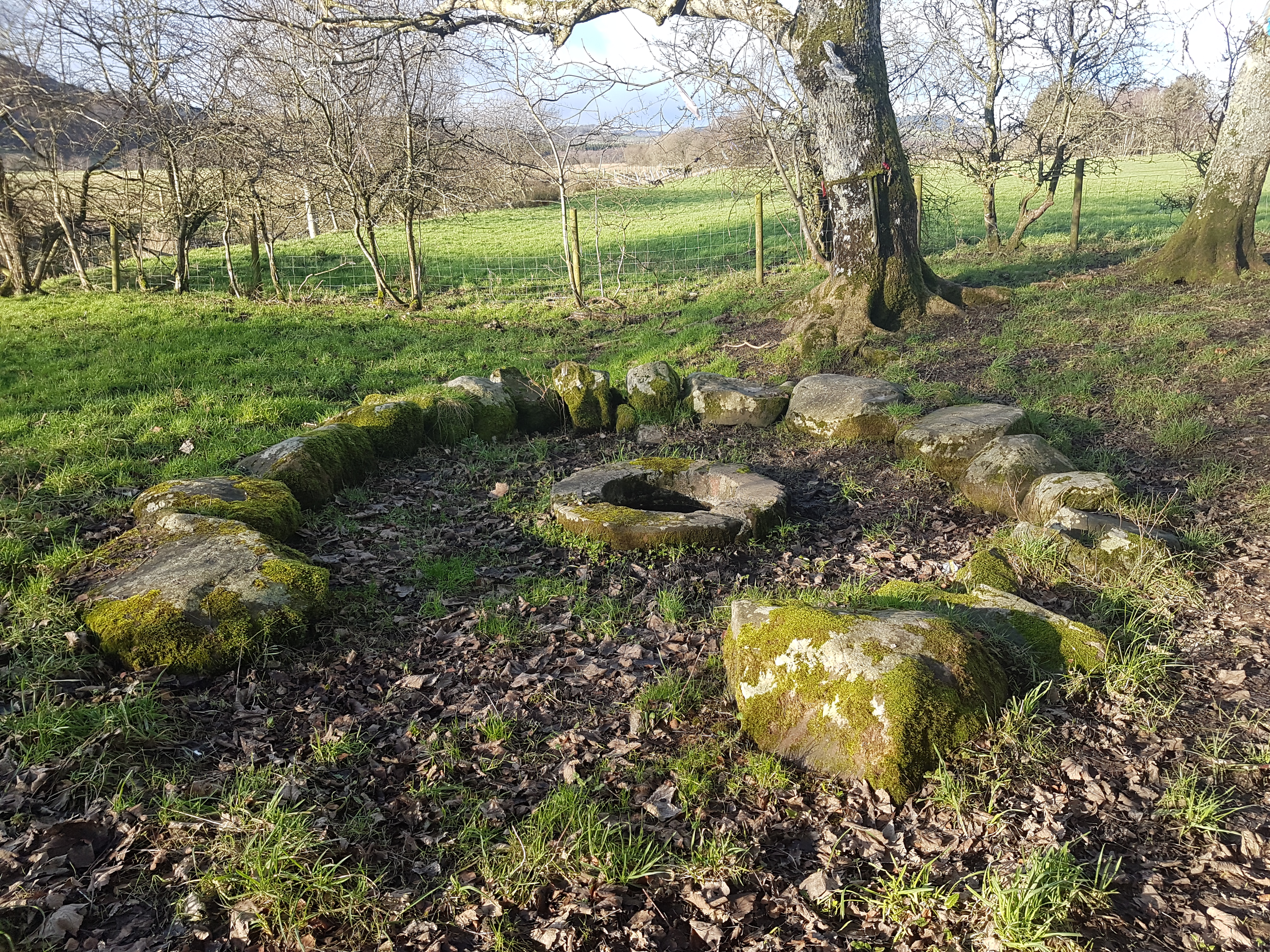
St Queran's Well

St Queran's Well is a holy well in Dumfries and Galloway, located in the parish of Troqueer in the historic county of Kirkcudbrightshire. A spring feeds...

River Nith

The River Nith (Scottish Gaelic: Abhainn Nid; Common Brittonic: Nowios) is a river in south-west Scotland. The Nith rises in the Carsphairn hills of East...

Nearby Amenities

Located within 500m of 55.020488,-3.6348995
Bus Stop
Mabie Forest
Naptan AtcoCode: 680000775111
Naptan Bearing: NE
Naptan BusStopType: CUS
Naptan CommonName: Mabie Forest
Naptan Indicator: Road End
Naptan Landmark: Mabie
Naptan NaptanCode: 34238674
Naptan Notes: none
Naptan Street: A710
Naptan Verified: no
Source: naptan_import
Lat/Long: 55.0198902/-3.6330434
Bus Stop
Mabie Forest
Naptan AtcoCode: 680000775222
Naptan Bearing: SW
Naptan BusStopType: CUS
Naptan CommonName: Mabie Forest
Naptan Indicator: opp Road End
Naptan Landmark: Mabie
Naptan NaptanCode: 34235743
Naptan Notes: none
Naptan Street: A710
Naptan Verified: no
Source: naptan_import
Lat/Long: 55.0197499/-3.6327874
Power: pole
Lat/Long: 55.020974/-3.6412535
Power: pole
Lat/Long: 55.0201506/-3.6412069
Power: pole
Lat/Long: 55.019118/-3.640912
Power: pole
Lat/Long: 55.0185646/-3.6398046
Power: pole
Lat/Long: 55.0186936/-3.6390196
Power: pole
Lat/Long: 55.0206918/-3.6420851
Power: pole
Lat/Long: 55.0215212/-3.6396137
Power: pole
Lat/Long: 55.0218776/-3.6385444
Power: pole
Lat/Long: 55.0221232/-3.6378104
Power: pole
Lat/Long: 55.0222534/-3.6362363
Power: pole
Lat/Long: 55.0221804/-3.6355108
Power: pole
Lat/Long: 55.0220515/-3.6342506
Power: pole
Lat/Long: 55.0214823/-3.633209
Power: pole
Lat/Long: 55.0209326/-3.6321737
Power: pole
Lat/Long: 55.0203549/-3.6311024
Power: pole
Lat/Long: 55.0197894/-3.6300587
Power: pole
Lat/Long: 55.0192372/-3.6290255
Power: pole
Lat/Long: 55.0189636/-3.6292568
Power: pole
Lat/Long: 55.0191594/-3.6299993
Power: pole
Lat/Long: 55.0193564/-3.6307481
Power: pole
Lat/Long: 55.0195364/-3.6314418
Power: pole
Lat/Long: 55.0197286/-3.6321483
Power: pole
Lat/Long: 55.019911/-3.6328484
Power: pole
Lat/Long: 55.0229174/-3.6336248
Power: pole
Lat/Long: 55.0238209/-3.6329714
Power: pole
Lat/Long: 55.0247184/-3.6323222
Power: pole
Lat/Long: 55.0211527/-3.6276466
Power: pole
Lat/Long: 55.0205471/-3.6280497
Power: pole
Lat/Long: 55.0198867/-3.6285312
Power: pole
Lat/Long: 55.018561/-3.6296238
Power: pole
Lat/Long: 55.0181645/-3.6299993
The data included in this document is from www.openstreetmap.org. The data is made available under ODbL.

Have you been to Avenue Wood?

Leave your review of Avenue Wood below (or comments, questions and feedback).