Barquhar Plantation

Wood, Forest in Kirkcudbrightshire

Scotland

Barquhar Plantation

The A75 road from the air The short dual carriageway section at Drummore is obscured by cloud at the top of the photo. Lochfoot and Northpark are on the right. A pipeline is being laid across the road, section of the pipe can be seen in the trench to the left of the road.
The A75 road from the air Credit: Thomas Nugent

Barquhar Plantation is a sprawling woodland located in Kirkcudbrightshire, a historic county in southwestern Scotland. Covering an area of approximately 100 hectares, the plantation is known for its diverse and abundant variety of trees, making it a haven for nature enthusiasts and hikers alike.

The plantation predominantly consists of broadleaf trees, including oak, beech, and ash, which create a picturesque and vibrant landscape throughout the year. These trees provide a lush canopy that shelters a rich undergrowth of ferns, mosses, and wildflowers, adding to the plantation's natural beauty.

Visitors to Barquhar Plantation can enjoy a network of well-maintained trails that meander through the woodland, offering stunning views and opportunities for wildlife spotting. The plantation is home to a range of animal species, including red squirrels, roe deer, and various bird species such as woodpeckers and owls.

The management of Barquhar Plantation places a strong emphasis on conservation and sustainability. The woodland is carefully managed to promote biodiversity and maintain a healthy ecosystem. This includes regular tree planting, selective felling, and the creation of wildlife habitats.

Barquhar Plantation also offers educational opportunities for schools and community groups, providing a venue for outdoor learning and environmental awareness. The plantation's educational programs focus on the importance of woodland habitats and the need for conservation efforts.

Overall, Barquhar Plantation in Kirkcudbrightshire is a remarkable woodland, providing a peaceful and biodiverse environment for both recreational activities and environmental education.

If you have any feedback on the listing, please let us know in the comments section below.

Barquhar Plantation Images

Images are sourced within 2km of 55.050464/-3.7553591 or Grid Reference NX8774. Thanks to Geograph Open Source API. All images are credited.

The A75 road from the air The short dual carriageway section at Drummore is obscured by cloud at the top of the photo. Lochfoot and Northpark are on the right. A pipeline is being laid across the road, section of the pipe can be seen in the trench to the left of the road.
The A75 road from the air
The short dual carriageway section at Drummore is obscured by cloud at the top of the photo. Lochfoot and Northpark are on the right. A pipeline is being laid across the road, section of the pipe can be seen in the trench to the left of the road.
The A75 road from the air The short dual carriageway section at Drummore is obscured by cloud at the top of the photo. Shealinghill is in the foreground, with Northpark beyond. A pipeline is being laid across the road, section of the pipe can be seen in the trench to the left of the road.
The A75 road from the air
The short dual carriageway section at Drummore is obscured by cloud at the top of the photo. Shealinghill is in the foreground, with Northpark beyond. A pipeline is being laid across the road, section of the pipe can be seen in the trench to the left of the road.
Henderland farm yard
Bogrie Lane from Bogrie Bridge
Sheep with lambs at Barnbackle
The triangulation pillar on Barnbackle Hill The trig point is in a grazing field at 184m with a flush bracket number S7916.
The triangulation pillar on Barnbackle Hill
The trig point is in a grazing field at 184m with a flush bracket number S7916.
Sheep and lambs on Barnbackle Hill The sheep were near the trig point on the hill.
Sheep and lambs on Barnbackle Hill
The sheep were near the trig point on the hill.
Whiteyard Farm The farm was viewed from a grazing field on Barnbackle Hill.
Whiteyard Farm
The farm was viewed from a grazing field on Barnbackle Hill.
Old Milestone by Merkland, Lochrutton Parish Affleck by the A75, in parish of Lochrutton (Stewartry District), Merkland East of farm, on verge near hedge, North side of road.

Inscription reads:- : C / {arrow} / 12 : : D / {arrow} / 5¾ : 
(To Castle Douglas and Dumfries)

Surveyed

Milestone Society National ID: DG_PPLN78
Old Milestone by Merkland, Lochrutton Parish
Affleck by the A75, in parish of Lochrutton (Stewartry District), Merkland East of farm, on verge near hedge, North side of road. Inscription reads:- : C / {arrow} / 12 : : D / {arrow} / 5¾ : (To Castle Douglas and Dumfries) Surveyed Milestone Society National ID: DG_PPLN78
Route 75 Diner The A75 is a Primary Trunk Road; the main through route for traffic between northern England and Northern Ireland (more specifically the ferry terminal from Cairnryan to Belfast and Larne). It runs for 95½ miles between Stranraer and the A74(M) at Gretna, close to the Border with England and the M6 Motorway. Although it is an important trunk route (it is also a Euroroute, the E18), and has been subject to a number of upgrades over the years, the majority of the road is still single-carriageway although there are a few short dual carriageway sections and some three-lane sections which allow overtaking in one direction.
Route 75 Diner
The A75 is a Primary Trunk Road; the main through route for traffic between northern England and Northern Ireland (more specifically the ferry terminal from Cairnryan to Belfast and Larne). It runs for 95½ miles between Stranraer and the A74(M) at Gretna, close to the Border with England and the M6 Motorway. Although it is an important trunk route (it is also a Euroroute, the E18), and has been subject to a number of upgrades over the years, the majority of the road is still single-carriageway although there are a few short dual carriageway sections and some three-lane sections which allow overtaking in one direction.
A75 near Shawhead The A75 is a Primary Trunk Road; the main through route for traffic between northern England and Northern Ireland (more specifically the ferry terminal from Cairnryan to Belfast and Larne). It runs for 95½ miles between Stranraer and the A74(M) at Gretna, close to the Border with England and the M6 Motorway. Although it is an important trunk route (it is also a Euroroute, the E18), and has been subject to a number of upgrades over the years, the majority of the road is still single-carriageway although there are a few short dual carriageway sections and some three-lane sections which allow overtaking in one direction.
A75 near Shawhead
The A75 is a Primary Trunk Road; the main through route for traffic between northern England and Northern Ireland (more specifically the ferry terminal from Cairnryan to Belfast and Larne). It runs for 95½ miles between Stranraer and the A74(M) at Gretna, close to the Border with England and the M6 Motorway. Although it is an important trunk route (it is also a Euroroute, the E18), and has been subject to a number of upgrades over the years, the majority of the road is still single-carriageway although there are a few short dual carriageway sections and some three-lane sections which allow overtaking in one direction.
Eastbound A75 The A75 is a Primary Trunk Road; the main through route for traffic between northern England and Northern Ireland (more specifically the ferry terminal from Cairnryan to Belfast and Larne). It runs for 95½ miles between Stranraer and the A74(M) at Gretna, close to the Border with England and the M6 Motorway. Although it is an important trunk route (it is also a Euroroute, the E18), and has been subject to a number of upgrades over the years, the majority of the road is still single-carriageway although there are a few short dual carriageway sections and some three-lane sections which allow overtaking in one direction.
Eastbound A75
The A75 is a Primary Trunk Road; the main through route for traffic between northern England and Northern Ireland (more specifically the ferry terminal from Cairnryan to Belfast and Larne). It runs for 95½ miles between Stranraer and the A74(M) at Gretna, close to the Border with England and the M6 Motorway. Although it is an important trunk route (it is also a Euroroute, the E18), and has been subject to a number of upgrades over the years, the majority of the road is still single-carriageway although there are a few short dual carriageway sections and some three-lane sections which allow overtaking in one direction.
Three Crofts The ground is higher here than further west and more sheep can be seen as opposed to Friesian cows.
Three Crofts
The ground is higher here than further west and more sheep can be seen as opposed to Friesian cows.
Barnbackle Hill Beside the Old Military Road.
Barnbackle Hill
Beside the Old Military Road.
Grazing cattle, Slacks
Over the blackthorn Young shoots flowering beside the wetland and carr that surrounds Loch Rutton.
Over the blackthorn
Young shoots flowering beside the wetland and carr that surrounds Loch Rutton.
Main Street, Lochfoot
Lochrutton Primary School In Lochfoot Village.
Lochrutton Primary School
In Lochfoot Village.
Show me another place!

Barquhar Plantation is located at Grid Ref: NX8774 (Lat: 55.050464, Lng: -3.7553591)

Unitary Authority: Dumfries and Galloway

Police Authority: Dumfries and Galloway

What 3 Words

///voltage.handover.conquest. Near Dumfries, Dumfries & Galloway

Nearby Locations

Barquhar Plantation

Related Wikis

Lochrutton Loch

Lochrutton Loch is a large, lowland freshwater loch that lies to the west of Dumfries, Scotland. The loch trends from north to south and is 0.75 mi (1...
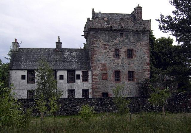
Hills Tower

Hills Tower is a sixteenth-century square tower house, with an adjoining eighteenth-century wing, near Dumfries in Scotland. Originally built around 1527...

Easthill stone circle

Easthill stone circle (grid reference NX91937388), also known as the Seven Grey Stanes, is a small oval stone circle 3¾ miles south-west of Dumfries. Eight...

Lochanhead railway station

Lochanhead railway station served the settlement of Lochanhead, Dumfries and Galloway, Scotland from 1859 to 1965 on the Castle Douglas and Dumfries Railway...

Nearby Amenities

Located within 500m of 55.050464,-3.7553591
Power: pole
Lat/Long: 55.0533974/-3.7590775
Power: pole
Lat/Long: 55.0529126/-3.758422
Power: pole
Lat/Long: 55.0525845/-3.758021
Power: pole
Lat/Long: 55.0514841/-3.7477426
Power: pole
Lat/Long: 55.050919/-3.7485255
Power: pole
Lat/Long: 55.0503211/-3.7493719
Power: pole
Lat/Long: 55.0497742/-3.7500974
The data included in this document is from www.openstreetmap.org. The data is made available under ODbL.

Have you been to Barquhar Plantation?

Leave your review of Barquhar Plantation below (or comments, questions and feedback).