Hightown Plantation
Wood, Forest in Dumfriesshire
Scotland
Hightown Plantation

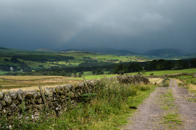
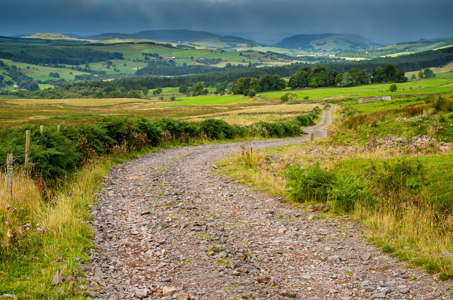
Hightown Plantation, located in Dumfriesshire, Scotland, is a picturesque wood and forest area that offers a tranquil and scenic experience for visitors. Covering an extensive area, the plantation is nestled amidst the rolling hills and lush greenery of the region, making it a popular destination for nature enthusiasts and hikers.
The woodlands of Hightown Plantation consist of a diverse range of tree species, including oak, beech, and birch, which create a vibrant and enchanting atmosphere. Walking along the well-maintained trails, visitors can immerse themselves in the natural beauty of the area, enjoying the peaceful ambiance and the soothing sounds of birdsong.
The plantation is also known for its rich wildlife, providing a habitat for a variety of species. Visitors may catch glimpses of deer, foxes, rabbits, and a wide array of bird species during their exploration of the woodlands.
To enhance the visitor experience, Hightown Plantation offers several amenities, including picnic areas and benches strategically placed to provide breathtaking views. These facilities allow visitors to relax and enjoy a moment of tranquility while surrounded by the beauty of nature.
In addition to its natural charm, Hightown Plantation also holds historical significance. The area was once home to a grand estate and a noble family, leaving behind remnants of old ruins that can be discovered while wandering through the woodlands.
Hightown Plantation in Dumfriesshire is an idyllic destination for those seeking a peaceful and immersive experience in the heart of Scotland's natural wonders.
If you have any feedback on the listing, please let us know in the comments section below.
Hightown Plantation Images
Images are sourced within 2km of 55.18783/-3.7824451 or Grid Reference NX8689. Thanks to Geograph Open Source API. All images are credited.


Hightown Plantation is located at Grid Ref: NX8689 (Lat: 55.18783, Lng: -3.7824451)
Unitary Authority: Dumfries and Galloway
Police Authority: Dumfries and Galloway
What 3 Words
///exchanges.twinkling.agrees. Near Thornhill, Dumfries & Galloway
Nearby Locations
Related Wikis

Barjarg Tower
Barjarg Tower is an L-plan tower house probably dating from 1680, four miles south-east of Penpont, Dumfriesshire, Scotland. It is attached to a 19th...
Crossford railway station
Crossford is a closed station of the Cairn Valley Light Railway branch, from Dumfries. It served the rural area of Crossford in Dumfries and Galloway...

Keir, Dumfries and Galloway
Keir is a civil parish, containing the small village of Keir Mill, in Dumfries and Galloway, Scotland, one mile south of Penpont. It was founded in the...
Barburgh Mill
Barburgh Mill is a hamlet composed of an old lint mill, later extended as a woollen mill and associated buildings which lies north of Auldgirth on the...
Brownhill Inn
Brownhill Inn, now just called Brownhill (NX 902 911), was an inn approximately 1 mile (1.6 km) mile south of Closeburn, on the A76, which itself is about...

Closeburn, Dumfries and Galloway
Closeburn (Scottish Gaelic: Cill Osbairn) is a village and civil parish in Dumfries and Galloway, Scotland. The village is on the A76 road 2+1⁄2 miles...
Closeburn railway station
Closeburn railway station was a railway station in Dumfries and Galloway north of Dumfries, serving a rural community with Wallace Hall and Closeburn Castle...
Dalgarnock
Dalgarnock, Dalgarno, Dalgarnoc was an ancient parish and a once considerable sized village in the Nithsdale area of Dumfries and Galloway, Scotland,...
Nearby Amenities
Located within 500m of 55.18783,-3.7824451Have you been to Hightown Plantation?
Leave your review of Hightown Plantation below (or comments, questions and feedback).