Bettyknowes Plantation

Wood, Forest in Kirkcudbrightshire

Scotland

Bettyknowes Plantation

View from a layby, Larglea On the A75
View from a layby, Larglea Credit: Richard Webb

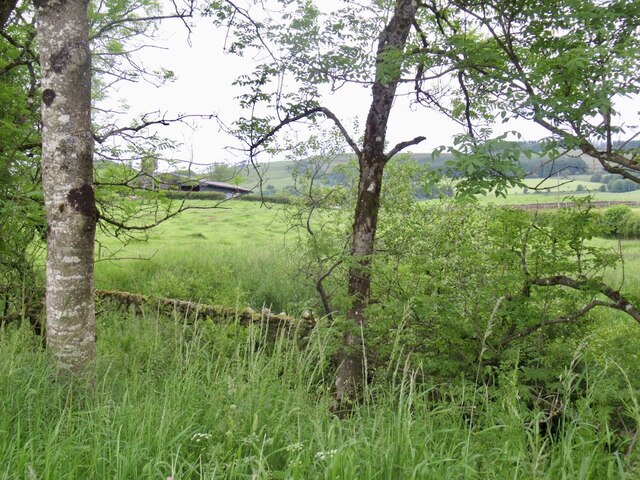
Bettyknowes Plantation is a sprawling woodland located in the rural area of Kirkcudbrightshire, Scotland. Situated on the outskirts of the town of Gatehouse of Fleet, the plantation covers a vast expanse of approximately 400 acres. It is renowned for its diverse range of tree species and serves as a haven for nature enthusiasts and outdoor enthusiasts alike.

The woodland is predominantly composed of coniferous trees, including Scots pine, Douglas fir, and Sitka spruce. These towering trees provide a dense canopy, creating a tranquil and serene atmosphere within the plantation. Mixed among the conifers are pockets of broadleaf trees such as oak, beech, and birch, adding to the richness of the woodland.

Bettyknowes Plantation offers a myriad of recreational activities for visitors to enjoy. There are several well-maintained trails that crisscross the woodland, allowing visitors to explore its beauty on foot or by bike. These trails range in difficulty, catering to both casual walkers and experienced hikers.

The woodland is also home to a diverse array of wildlife. Birdwatchers can spot numerous species of birds, including woodpeckers, owls, and various migratory birds. Red squirrels and roe deer are commonly spotted within the woodland, while elusive pine martens and badgers occasionally make an appearance.

Overall, Bettyknowes Plantation is a captivating woodland retreat that offers an escape from the hustle and bustle of everyday life. Its stunning scenery, diverse flora, and fauna, and numerous recreational opportunities make it a must-visit destination for nature enthusiasts and outdoor adventurers.

If you have any feedback on the listing, please let us know in the comments section below.

Bettyknowes Plantation Images

Images are sourced within 2km of 55.047607/-3.7989539 or Grid Reference NX8574. Thanks to Geograph Open Source API. All images are credited.

View from a layby, Larglea On the A75
View from a layby, Larglea
On the A75
Entrance to Bettyknowes Farm
Layby on part of the old route of the A75, Crocketford
The A75 north-east of Crocketford
Layby on the A75 near Crocketford The A75 is a Primary Trunk Road; the main through route for traffic between northern England and Northern Ireland (more specifically the ferry terminal from Cairnryan to Belfast and Larne). It runs for 95½ miles between Stranraer and the A74(M) at Gretna, close to the Border with England and the M6 Motorway. Although it is an important trunk route (it is also a Euroroute, the E18), and has been subject to a number of upgrades over the years, the majority of the road is still single-carriageway although there are a few short dual carriageway sections and some three-lane sections which allow overtaking in one direction.
Layby on the A75 near Crocketford
The A75 is a Primary Trunk Road; the main through route for traffic between northern England and Northern Ireland (more specifically the ferry terminal from Cairnryan to Belfast and Larne). It runs for 95½ miles between Stranraer and the A74(M) at Gretna, close to the Border with England and the M6 Motorway. Although it is an important trunk route (it is also a Euroroute, the E18), and has been subject to a number of upgrades over the years, the majority of the road is still single-carriageway although there are a few short dual carriageway sections and some three-lane sections which allow overtaking in one direction.
A75 near Crocketford The A75 is a Primary Trunk Road; the main through route for traffic between northern England and Northern Ireland (more specifically the ferry terminal from Cairnryan to Belfast and Larne). It runs for 95½ miles between Stranraer and the A74(M) at Gretna, close to the Border with England and the M6 Motorway. Although it is an important trunk route (it is also a Euroroute, the E18), and has been subject to a number of upgrades over the years, the majority of the road is still single-carriageway although there are a few short dual carriageway sections and some three-lane sections which allow overtaking in one direction.
A75 near Crocketford
The A75 is a Primary Trunk Road; the main through route for traffic between northern England and Northern Ireland (more specifically the ferry terminal from Cairnryan to Belfast and Larne). It runs for 95½ miles between Stranraer and the A74(M) at Gretna, close to the Border with England and the M6 Motorway. Although it is an important trunk route (it is also a Euroroute, the E18), and has been subject to a number of upgrades over the years, the majority of the road is still single-carriageway although there are a few short dual carriageway sections and some three-lane sections which allow overtaking in one direction.
Route 75 Diner The A75 is a Primary Trunk Road; the main through route for traffic between northern England and Northern Ireland (more specifically the ferry terminal from Cairnryan to Belfast and Larne). It runs for 95½ miles between Stranraer and the A74(M) at Gretna, close to the Border with England and the M6 Motorway. Although it is an important trunk route (it is also a Euroroute, the E18), and has been subject to a number of upgrades over the years, the majority of the road is still single-carriageway although there are a few short dual carriageway sections and some three-lane sections which allow overtaking in one direction.
Route 75 Diner
The A75 is a Primary Trunk Road; the main through route for traffic between northern England and Northern Ireland (more specifically the ferry terminal from Cairnryan to Belfast and Larne). It runs for 95½ miles between Stranraer and the A74(M) at Gretna, close to the Border with England and the M6 Motorway. Although it is an important trunk route (it is also a Euroroute, the E18), and has been subject to a number of upgrades over the years, the majority of the road is still single-carriageway although there are a few short dual carriageway sections and some three-lane sections which allow overtaking in one direction.
A75 near Shawhead The A75 is a Primary Trunk Road; the main through route for traffic between northern England and Northern Ireland (more specifically the ferry terminal from Cairnryan to Belfast and Larne). It runs for 95½ miles between Stranraer and the A74(M) at Gretna, close to the Border with England and the M6 Motorway. Although it is an important trunk route (it is also a Euroroute, the E18), and has been subject to a number of upgrades over the years, the majority of the road is still single-carriageway although there are a few short dual carriageway sections and some three-lane sections which allow overtaking in one direction.
A75 near Shawhead
The A75 is a Primary Trunk Road; the main through route for traffic between northern England and Northern Ireland (more specifically the ferry terminal from Cairnryan to Belfast and Larne). It runs for 95½ miles between Stranraer and the A74(M) at Gretna, close to the Border with England and the M6 Motorway. Although it is an important trunk route (it is also a Euroroute, the E18), and has been subject to a number of upgrades over the years, the majority of the road is still single-carriageway although there are a few short dual carriageway sections and some three-lane sections which allow overtaking in one direction.
Bettyknowes Farm by the side of the A75.
Bettyknowes
Farm by the side of the A75.
Barfil Farm and Milton Loch Overlooking the steading at Barfil Farm, with Milton Loch in the distance
Barfil Farm and Milton Loch
Overlooking the steading at Barfil Farm, with Milton Loch in the distance
Baril Farm Barfil, with Milton Loch in the distance
Baril Farm
Barfil, with Milton Loch in the distance
Field with horses and plough This is at Barfil Farm
Field with horses and plough
This is at Barfil Farm
Brae Cottages Looking along the A75 towards Crocketford.
Brae Cottages
Looking along the A75 towards Crocketford.
Brae Cottages First cottage on the left is West Brae, then East Brae which is a B&B, with a view along the A75.
Brae Cottages
First cottage on the left is West Brae, then East Brae which is a B&B, with a view along the A75.
Brae Cottages Looking over to Hillhead.
Brae Cottages
Looking over to Hillhead.
Brae Cottages View over to Bettyknowes Hill.
Brae Cottages
View over to Bettyknowes Hill.
Henderland Looking along the A75 towards Stranraer.
Henderland
Looking along the A75 towards Stranraer.
Diner open in layby on A75 westbound
Show me another place!

Bettyknowes Plantation is located at Grid Ref: NX8574 (Lat: 55.047607, Lng: -3.7989539)

Unitary Authority: Dumfries and Galloway

Police Authority: Dumfries and Galloway

What 3 Words

///expansion.vent.cocoons. Near Dumfries, Dumfries & Galloway

Nearby Locations

Bettyknowes Plantation

Related Wikis

Crocketford

Crocketford (/ˈkrɒkɪtfɔːd/, also frequently /ˈkrɒkɪtfəd/) also known as Ninemile Bar (Scottish Gaelic: Ath Crogaid), as it is approximately equidistant...

Milton Loch

Milton Loch is an alkaline freshwater loch located in Dumfries and Galloway, Scotland. In the loch and nearby are archaeological sites including three...

Glenkiln Sculpture Park

Glenkiln Sculpture Park was a sculpture landscape in the historic county of Kirkcudbrightshire in Dumfries and Galloway, south-west Scotland. After one...

Lochrutton Loch

Lochrutton Loch is a large, lowland freshwater loch that lies to the west of Dumfries, Scotland. The loch trends from north to south and is 0.75 mi (1...

Nearby Amenities

Located within 500m of 55.047607,-3.7989539
Power: pole
Lat/Long: 55.0460971/-3.792049
Power: pole
Lat/Long: 55.0457094/-3.7930228
Power: pole
Lat/Long: 55.0471861/-3.7915759
Power: pole
Lat/Long: 55.0476516/-3.7919833
Power: pole
Lat/Long: 55.0483164/-3.7926197
Power: pole
Lat/Long: 55.049042/-3.7935468
Power: pole
Lat/Long: 55.0497359/-3.7944547
Power: pole
Lat/Long: 55.0503569/-3.7952312
Power: pole
Lat/Long: 55.0509123/-3.795961
The data included in this document is from www.openstreetmap.org. The data is made available under ODbL.

Have you been to Bettyknowes Plantation?

Leave your review of Bettyknowes Plantation below (or comments, questions and feedback).