Dalraddy Moor

Wood, Forest in Inverness-shire

Scotland

Dalraddy Moor

River Spey The Spey is 107 miles long. Important for Salmon fishing and whisky distilling.
Wikipedia: <span class="nowrap"><a title="https://en.wikipedia.org/wiki/River_Spey" rel="nofollow ugc noopener" href="https://en.wikipedia.org/wiki/River_Spey">Link</a><img style="margin-left:2px;" alt="External link" title="External link - shift click to open in new window" src="https://s1.geograph.org.uk/img/external.png" width="10" height="10"/></span>
River Spey Credit: N Chadwick

Dalraddy Moor, located in Inverness-shire, Scotland, is a picturesque and enchanting wood and forest area. Spanning over a vast expanse, it is a captivating natural landscape that offers visitors a unique and immersive experience.

The moor is characterized by its lush greenery, with an abundance of tall, majestic trees that create a dense and mysterious forest. The dominant tree species in the area include Scots pine, birch, and oak, which contribute to the rich biodiversity found within the woodland.

The forest floor is covered in a thick carpet of mosses, ferns, and wildflowers, adding to the area's natural charm. This diverse vegetation provides a habitat for a wide range of wildlife, including deer, squirrels, birds, and various small mammals.

Dalraddy Moor is a popular destination for nature lovers and outdoor enthusiasts. It offers a multitude of walking trails and paths that wind through the forest, allowing visitors to explore its hidden corners and discover its natural wonders. The tranquil atmosphere and the soothing sounds of rustling leaves and chirping birds make it an ideal location for those seeking peace and solitude in nature.

In addition to its beauty, Dalraddy Moor also holds historical significance. The area is known for its ancient ruins and archaeological sites, with remnants of ancient settlements and burial sites dating back centuries.

Overall, Dalraddy Moor in Inverness-shire is a captivating wood and forest area, offering a blend of natural beauty, biodiversity, and historical significance. It is a place where visitors can immerse themselves in the tranquility of nature while exploring its hidden treasures.

If you have any feedback on the listing, please let us know in the comments section below.

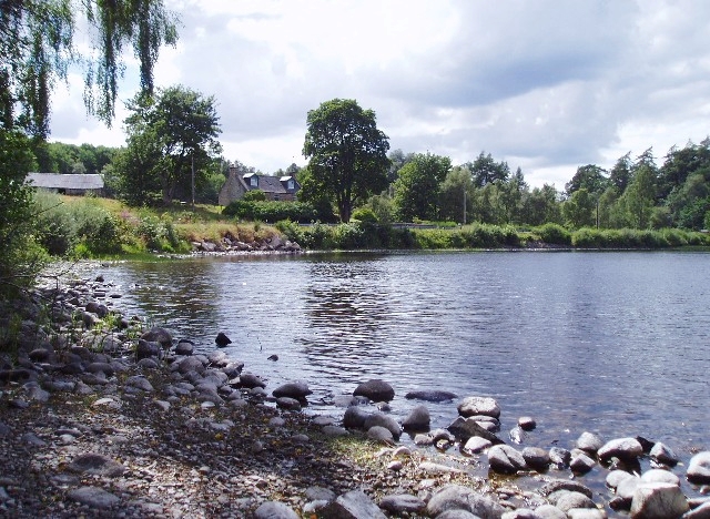
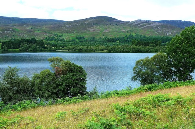
Dalraddy Moor Images

Images are sourced within 2km of 57.14575/-3.9026751 or Grid Reference NH8407. Thanks to Geograph Open Source API. All images are credited.

River Spey The Spey is 107 miles long. Important for Salmon fishing and whisky distilling.
Wikipedia: <span class="nowrap"><a title="https://en.wikipedia.org/wiki/River_Spey" rel="nofollow ugc noopener" href="https://en.wikipedia.org/wiki/River_Spey">Link</a><img style="margin-left:2px;" alt="External link" title="External link - shift click to open in new window" src="https://s1.geograph.org.uk/img/external.png" width="10" height="10"/></span>
River Spey
The Spey is 107 miles long. Important for Salmon fishing and whisky distilling. Wikipedia: LinkExternal link
A glimpse of the River Spey
Woodland by the River Spey
Woodland in the Spey Valley
Footpath by River Spey
Bracken, Speyside For the Wikipedia article on bracken see <span class="nowrap"><a title="http://en.wikipedia.org/wiki/Bracken" rel="nofollow ugc noopener" href="http://en.wikipedia.org/wiki/Bracken">Link</a><img style="margin-left:2px;" alt="External link" title="External link - shift click to open in new window" src="https://s1.geograph.org.uk/img/external.png" width="10" height="10"/></span>
Bracken, Speyside
For the Wikipedia article on bracken see LinkExternal link
Speyside
Speyside
Speyside woodland
Speyside woodland
Speyside Way The Speyside Way is a 137 km long, long-distance path in the Scottish Highlands. The route begins in Buckie and ends at Newtonmore. 
The route primarily follows the River Spey through the scenery of Banffshire, Morayshire and Inverness-shire, passing some of the distilleries that produce Speyside single malts. The first section from Buckie to Spey Bay follows the coastline, while the final section from Aviemore to Newtonmore follows most of the route of the former Strathspey Railway. It is listed as one of Scotland's Great Trails by NatureScot, and links directly to two further Great Trails: the Dava Way and the Moray Coast Trail. The route is waymarked with a symbol showing a thistle in a hexagon.
Speyside Way
The Speyside Way is a 137 km long, long-distance path in the Scottish Highlands. The route begins in Buckie and ends at Newtonmore. The route primarily follows the River Spey through the scenery of Banffshire, Morayshire and Inverness-shire, passing some of the distilleries that produce Speyside single malts. The first section from Buckie to Spey Bay follows the coastline, while the final section from Aviemore to Newtonmore follows most of the route of the former Strathspey Railway. It is listed as one of Scotland's Great Trails by NatureScot, and links directly to two further Great Trails: the Dava Way and the Moray Coast Trail. The route is waymarked with a symbol showing a thistle in a hexagon.
Speyside woods
Speyside woods
Highland Mainline
Highland Mainline
B9152 The B9152 runs 13 miles from Kingussie to Aviemore.
<span class="nowrap"><a title="https://www.sabre-roads.org.uk/wiki/index.php?title=B9152" rel="nofollow ugc noopener" href="https://www.sabre-roads.org.uk/wiki/index.php?title=B9152">Link</a><img style="margin-left:2px;" alt="External link" title="External link - shift click to open in new window" src="https://s1.geograph.org.uk/img/external.png" width="10" height="10"/></span>
B9152
The B9152 runs 13 miles from Kingussie to Aviemore. LinkExternal link
1H09 (170414) bound for Inverness near Wester Speybank
Show me another place!

Dalraddy Moor is located at Grid Ref: NH8407 (Lat: 57.14575, Lng: -3.9026751)

Unitary Authority: Highland

Police Authority: Highlands and Islands

What 3 Words

///package.unicorns.boomers. Near Aviemore, Highland

Nearby Locations

Loch Bourn Dalraddy Moor

Related Wikis

River Feshie

The River Feshie (Scottish Gaelic: Fèisidh / Abhainn Fhèisidh) is a major right bank tributary of the River Spey in north-east Scotland. It rises in the...

Dalnavert, Highland

Dalnavert (Scottish Gaelic Dail nam Feart) is a small rural hamlet, that lies 4 miles northeast of Insh, and 8 miles northeast of Kingussie, in the...

Alvie

Alvie (Scottish Gaelic: Albhaidh) is a small crofting hamlet, a working Scottish highland estate and civil parish, located on the south shore of Loch Alvie...

Loch Alvie

Loch Alvie is a loch located north of the River Spey, in the civil parish of Alvie, in the council area of Highland, Scotland. The loch is about two miles...

Nearby Amenities

Located within 500m of 57.14575,-3.9026751
Parking
Parking: layby
Source: survey
Lat/Long: 57.1464686/-3.9075229
The data included in this document is from www.openstreetmap.org. The data is made available under ODbL.

Have you been to Dalraddy Moor?

Leave your review of Dalraddy Moor below (or comments, questions and feedback).