Baluain Wood

Wood, Forest in Perthshire

Scotland

Baluain Wood

Falls of Bruar On a gorgeous summer's day but I have to say I prefer them in autumn.
Falls of Bruar Credit: David Bremner

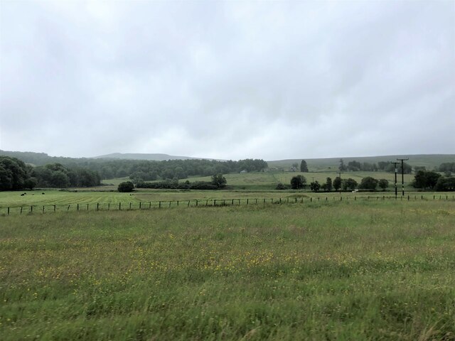
Baluain Wood is a picturesque forest located in Perthshire, Scotland. Covering an area of approximately 100 hectares, it is nestled in the heart of the scenic countryside, offering visitors a tranquil escape from the hustle and bustle of everyday life.

The woodland is characterized by a diverse range of trees, including oak, birch, and pine, which create a rich and vibrant landscape. The forest floor is covered with a lush carpet of ferns, mosses, and wildflowers, adding to its natural beauty.

Baluain Wood is home to a variety of wildlife, making it a popular destination for nature enthusiasts and bird watchers. Visitors may spot red squirrels, roe deer, and a wide array of bird species, including woodpeckers, owls, and buzzards.

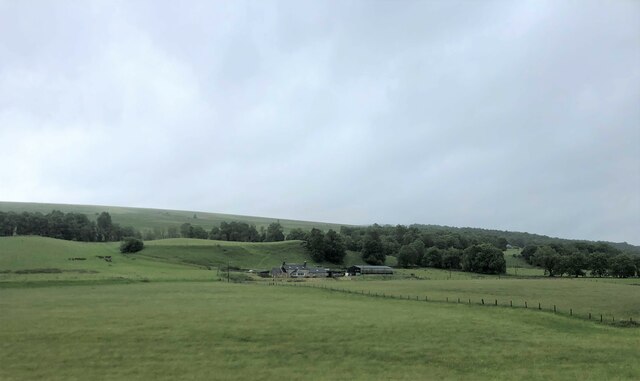
The forest offers a network of well-maintained trails, allowing visitors to explore the woodland at their own pace. These paths meander through the forest, leading to stunning viewpoints and hidden gems, such as a picturesque waterfall and a tranquil pond.

Aside from its natural beauty, Baluain Wood also has historical significance. The remains of an ancient fort can be found within the forest, offering a glimpse into the area's past.

Whether it's a leisurely stroll, bird watching, or simply enjoying the serenity of nature, Baluain Wood provides a haven for all who visit. With its enchanting landscapes and abundant wildlife, it truly is a hidden gem in the heart of Perthshire.

If you have any feedback on the listing, please let us know in the comments section below.

Baluain Wood Images

Images are sourced within 2km of 56.778966/-3.9164246 or Grid Reference NN8266. Thanks to Geograph Open Source API. All images are credited.

Falls of Bruar On a gorgeous summer's day but I have to say I prefer them in autumn.
Falls of Bruar
On a gorgeous summer's day but I have to say I prefer them in autumn.
A Warm Welcome Several of these about the place.
A Warm Welcome
Several of these about the place.
Parkland with birch trees in Glen Garry
A9, Glen Garry The A9 is a strategic link between the Highlands of Scotland and the Central Belt. It runs 279 miles from junction 5 of the M9 at Polmont to Scrabster. Originally it ran from Edinburgh.
<span class="nowrap"><a title="https://www.sabre-roads.org.uk/wiki/index.php?title=A9" rel="nofollow ugc noopener" href="https://www.sabre-roads.org.uk/wiki/index.php?title=A9">Link</a><img style="margin-left:2px;" alt="External link" title="External link - shift click to open in new window" src="https://s1.geograph.org.uk/img/external.png" width="10" height="10"/></span>
A9, Glen Garry
The A9 is a strategic link between the Highlands of Scotland and the Central Belt. It runs 279 miles from junction 5 of the M9 at Polmont to Scrabster. Originally it ran from Edinburgh. LinkExternal link
A9, northbound The A9 is a strategic link between the Highlands of Scotland and the Central Belt. It runs 279 miles from junction 5 of the M9 at Polmont to Scrabster. Originally it ran from Edinburgh.
<span class="nowrap"><a title="https://www.sabre-roads.org.uk/wiki/index.php?title=A9" rel="nofollow ugc noopener" href="https://www.sabre-roads.org.uk/wiki/index.php?title=A9">Link</a><img style="margin-left:2px;" alt="External link" title="External link - shift click to open in new window" src="https://s1.geograph.org.uk/img/external.png" width="10" height="10"/></span>
A9, northbound
The A9 is a strategic link between the Highlands of Scotland and the Central Belt. It runs 279 miles from junction 5 of the M9 at Polmont to Scrabster. Originally it ran from Edinburgh. LinkExternal link
A9 at the River Garry The A9 is a strategic link between the Highlands of Scotland and the Central Belt. It runs 279 miles from junction 5 of the M9 at Polmont to Scrabster. Originally it ran from Edinburgh.
<span class="nowrap"><a title="https://www.sabre-roads.org.uk/wiki/index.php?title=A9" rel="nofollow ugc noopener" href="https://www.sabre-roads.org.uk/wiki/index.php?title=A9">Link</a><img style="margin-left:2px;" alt="External link" title="External link - shift click to open in new window" src="https://s1.geograph.org.uk/img/external.png" width="10" height="10"/></span>
A9 at the River Garry
The A9 is a strategic link between the Highlands of Scotland and the Central Belt. It runs 279 miles from junction 5 of the M9 at Polmont to Scrabster. Originally it ran from Edinburgh. LinkExternal link
Layby - A9 northbound
Signage - A9 northbound
Farmland near Invervack
Pitaldonick Farm in Glen Garry
River Garry at Bruar
A9 east of Bruar
A9 east of Bruar
Ben Vrackie from near Bruar
Parkland at Blair Castle
Glebe Steading
Glebe Steading
Heathery slopes above Pitagowan
Gated entry for Blair Castle from B8079 The impressive gate and gatehouse into the Blair Castle parkland from the B road which would of course have been the A9 before its complete realignment. Visitors to the castle are directed to the main entrance to the castle and its grounds, a further two miles along the road.
Gated entry for Blair Castle from B8079
The impressive gate and gatehouse into the Blair Castle parkland from the B road which would of course have been the A9 before its complete realignment. Visitors to the castle are directed to the main entrance to the castle and its grounds, a further two miles along the road.
Show me another place!

Baluain Wood is located at Grid Ref: NN8266 (Lat: 56.778966, Lng: -3.9164246)

Unitary Authority: Perth and Kinross

Police Authority: Tayside

What 3 Words

///fruits.morphing.denote. Near Blair Atholl, Perth & Kinross

Nearby Locations

Baluain Wood

Related Wikis

Falls of Bruar

The Falls of Bruar are a series of waterfalls on the Bruar Water in Scotland, about 8 miles (13 kilometres) from Pitlochry in the council area of Perth...

Calvine

Calvine is a hamlet in Perth and Kinross, Scotland.It is sandwiched between the A9 road, to its north, and the Highland mainline railway and River Garry...

Struan, Perthshire

Struan is a small village in Perthshire in Scotland. The name derives from sruthan, the Gaelic for 'Little Stream'. It is 8 km west of Blair Atholl.It...

Black Island Platform railway station

Black Island Platform railway station, Blair Atholl, Perth and Kinross, Scotland, was located at an area known as the Black Island beside the River Garry...

Struan railway station

Struan railway station served the village of Struan, Perthshire, Scotland from 1863 to 1965 on the Inverness and Perth Junction Railway. == History... ==

Old Blair

Old Blair is a tiny village of 18th century stone houses in Perth and Kinross, Scotland, adjoining and overlooking the grounds of Blair Castle. It is...

Blair Castle

Blair Castle (in Scottish Gaelic: Caisteil Bhlàir) stands in its grounds near the village of Blair Atholl in Perthshire in Scotland. It is the ancestral...

River Garry, Perthshire

The River Garry (Scottish Gaelic: Gar / Abhainn Ghar) is a major tributary of the River Tummel, itself a tributary of the River Tay, in the traditional...

Have you been to Baluain Wood?

Leave your review of Baluain Wood below (or comments, questions and feedback).