Carbarns Wood

Wood, Forest in Lanarkshire

Scotland

Carbarns Wood

Sewage works access bridge crosses the M74
Sewage works access bridge crosses the M74 Credit: Anthony Parkes

Carbarns Wood is a picturesque woodland located in the county of Lanarkshire, Scotland. Covering an area of approximately 100 acres, this woodland is a haven for nature enthusiasts and outdoor adventurers alike.

Situated just a few miles outside of the town of Lanark, Carbarns Wood boasts a diverse range of flora and fauna, making it a popular destination for those seeking a tranquil escape from the hustle and bustle of everyday life. The wood is predominantly composed of native tree species such as oak, birch, and beech, creating a rich and vibrant ecosystem.

Visitors to Carbarns Wood can enjoy a variety of activities, including walking, birdwatching, and photography. There are numerous well-maintained trails that wind through the woodland, offering breathtaking views and the chance to spot various bird species, such as woodpeckers and owls. The peaceful atmosphere of the wood also makes it an ideal spot for a picnic or a leisurely stroll.

Carbarns Wood is not only a recreational area but also plays a vital role in conservation efforts. The wood is home to several protected species, including red squirrel and roe deer, contributing to the preservation of Scotland's native wildlife.

Overall, Carbarns Wood is a hidden gem in Lanarkshire, offering visitors a chance to reconnect with nature and explore the beauty of Scotland's woodlands. Whether you are an avid hiker, a wildlife enthusiast, or simply seeking a peaceful retreat, Carbarns Wood is a destination that promises to leave a lasting impression.

If you have any feedback on the listing, please let us know in the comments section below.

Carbarns Wood Images

Images are sourced within 2km of 55.759783/-3.9508749 or Grid Reference NS7753. Thanks to Geograph Open Source API. All images are credited.

Sewage works access bridge crosses the M74
New stabling by the River Clyde Not shown on current mapping.  Taken from the Clyde Walkway.
New stabling by the River Clyde
Not shown on current mapping. Taken from the Clyde Walkway.
Steps and footbridge on the Clyde Walkway The Clyde Walkway is some 40miles/65 km long, running between Partick in Glasgow and New Lanark in South Lanarkshire.
Steps and footbridge on the Clyde Walkway
The Clyde Walkway is some 40miles/65 km long, running between Partick in Glasgow and New Lanark in South Lanarkshire.
The Clyde Walkway approaching Upper Carbarns The Clyde Walkway is some 40miles/65 km long, running between Partick in Glasgow and New Lanark in South Lanarkshire. The River Clyde is just visible to the left.
The Clyde Walkway approaching Upper Carbarns
The Clyde Walkway is some 40miles/65 km long, running between Partick in Glasgow and New Lanark in South Lanarkshire. The River Clyde is just visible to the left.
The River Clyde at Upper Carbarns The river is slow-flowing and deep at this point.  Taken from the Clyde Walkway which is some 40miles/65 km long, running between Partick in Glasgow and New Lanark in South Lanarkshire.
The River Clyde at Upper Carbarns
The river is slow-flowing and deep at this point. Taken from the Clyde Walkway which is some 40miles/65 km long, running between Partick in Glasgow and New Lanark in South Lanarkshire.
On the Clyde Walkway The Clyde Walkway is some 40miles/65 km long, running between Partick in Glasgow and New Lanark in South Lanarkshire. The Clyde is calm and deep at this point.

At this point the path follows an excellent concrete track which leads to Lower Carbarns.
On the Clyde Walkway
The Clyde Walkway is some 40miles/65 km long, running between Partick in Glasgow and New Lanark in South Lanarkshire. The Clyde is calm and deep at this point. At this point the path follows an excellent concrete track which leads to Lower Carbarns.
The River Clyde at Lower Carbarns Deep and slow-flowing at this point, the recent spates have eroded a bit more of the bank here.

Taken on the Clyde Walkway, which is some 40miles/65 km long, running between Partick in Glasgow and New Lanark in South Lanarkshire.
The River Clyde at Lower Carbarns
Deep and slow-flowing at this point, the recent spates have eroded a bit more of the bank here. Taken on the Clyde Walkway, which is some 40miles/65 km long, running between Partick in Glasgow and New Lanark in South Lanarkshire.
South Lanarkshire : The M74 Motorway Looking along the M74 motorway.
South Lanarkshire : The M74 Motorway
Looking along the M74 motorway.
South Lanarkshire : The M74 Motorway - Junction 7 The Larkhall Interchange on the M74.
South Lanarkshire : The M74 Motorway - Junction 7
The Larkhall Interchange on the M74.
South Lanarkshire : The M74 Motorway Looking along the M74 motorway.
South Lanarkshire : The M74 Motorway
Looking along the M74 motorway.
Lanark Road, heading north
North bound slip road onto the M74
High flats in Muirhouse
Cambusnethan Priory Built in the Gothic revival style it was designed by James Gillespi Graham and completed in 1820. Sadly it now lies derelict having been damaged by vandalism and fire. However possibilities of restoration are on the cards.
Cambusnethan Priory
Built in the Gothic revival style it was designed by James Gillespi Graham and completed in 1820. Sadly it now lies derelict having been damaged by vandalism and fire. However possibilities of restoration are on the cards.
Grazing Ground This long tract of grazing lies beside the River Clyde to the south of Netherton.
Grazing Ground
This long tract of grazing lies beside the River Clyde to the south of Netherton.
Junction of M74 slip road and A72
Erosion on banks of the River Clyde There has been erosion at various points along the Clyde Walkway as it passes through the Dalzell Estate and the Motherwell area.
Erosion on banks of the River Clyde
There has been erosion at various points along the Clyde Walkway as it passes through the Dalzell Estate and the Motherwell area.
Clyde Walkway near Motherwell A section of the path approaching Lower Carbarns on a frosty day when the temperature failed to rise above freezing.
Clyde Walkway near Motherwell
A section of the path approaching Lower Carbarns on a frosty day when the temperature failed to rise above freezing.
Show me another place!

Carbarns Wood is located at Grid Ref: NS7753 (Lat: 55.759783, Lng: -3.9508749)

Unitary Authority: North Lanarkshire

Police Authority: Lanarkshire

What 3 Words

///circle.upon.linked. Near Wishaw, North Lanarkshire

Nearby Locations

Carbarns Wood

Related Wikis

Cambusnethan House

Cambusnethan House, or Cambusnethan Priory, in North Lanarkshire, Scotland, was designed by James Gillespie Graham and completed in 1820. It is listed...

Netherton, North Lanarkshire

Netherton is a southerly suburb of Wishaw, which can be entered from Netherton Road, which runs easterly from Pickering's Corner to the Cherry Tree public...
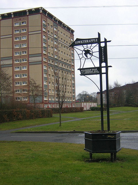
Gowkthrapple

Gowkthrapple is a small neighbourhood of Wishaw, Scotland, situated around 3⁄4 miles (1.2 km) from the town centre. The name "Gowkthrapple" is a Scots...

Wishaw South railway station

Wishaw South was one of two stations that served the town of Wishaw in Scotland between 1841 and 1958, the other station being Wishaw Central. It was on...

University Hospital Wishaw

University Hospital Wishaw (formerly known as Wishaw General Hospital) is a district general hospital in Wishaw, North Lanarkshire, situated between...

Muirhouse, North Lanarkshire

Muirhouse is a residential suburb in the south-east of Motherwell, North Lanarkshire, Scotland, coming under the Motherwell South East & Ravenscraig council...

Pather

Pather is a suburb of Wishaw, Scotland and was initially built as a council estate. It is situated around ½ miles (0.8 km) from the town centre. Pather...

Larkhall East railway station

Larkhall East railway station served the town of Larkhall, in the historical county of Lanarkshire, Scotland, from 1866 to 1951 on the Lesmahagow Railway...

Nearby Amenities

Located within 500m of 55.759783,-3.9508749
Design: three-level
Power: tower
Lat/Long: 55.7615784/-3.9469719
Design: three-level
Power: tower
Lat/Long: 55.7632947/-3.950872
Power: pole
Lat/Long: 55.7558039/-3.95297
Power: pole
Lat/Long: 55.7564664/-3.9524261
Power: pole
Lat/Long: 55.7571159/-3.9519177
Power: pole
Lat/Long: 55.7577514/-3.9514218
Power: pole
Lat/Long: 55.7578863/-3.9508155
Power: pole
Lat/Long: 55.7582919/-3.9501403
Power: pole
Lat/Long: 55.7588465/-3.9494194
Power: pole
Lat/Long: 55.7596004/-3.948488
Power: pole
Lat/Long: 55.7603507/-3.9474982
Power: pole
Lat/Long: 55.7607798/-3.9468877
Power: pole
Lat/Long: 55.7614293/-3.9460626
Power: pole
Lat/Long: 55.7573586/-3.950505
Power: pole
Lat/Long: 55.7569436/-3.9495423
Power: pole
Lat/Long: 55.7565438/-3.9486005
Power: pole
Lat/Long: 55.7564793/-3.9484484
Power: pole
Lat/Long: 55.7594186/-3.9430725
Power: pole
Lat/Long: 55.7589356/-3.9436476
Power: pole
Lat/Long: 55.7585839/-3.9446624
Power: pole
Lat/Long: 55.7582521/-3.945625
Power: pole
Lat/Long: 55.7580176/-3.946323
Power: pole
Lat/Long: 55.7574583/-3.9478275
Power: pole
Lat/Long: 55.7557312/-3.9489193
The data included in this document is from www.openstreetmap.org. The data is made available under ODbL.

Have you been to Carbarns Wood?

Leave your review of Carbarns Wood below (or comments, questions and feedback).