Moss Plantation

Wood, Forest in Kirkcudbrightshire

Scotland

Moss Plantation

Forest track giving access to Tydeaverrys Hill Looking north-westward.
Forest track giving access to Tydeaverrys Hill Credit: Peter Wood

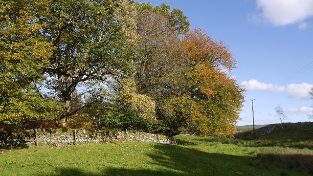
Moss Plantation is a picturesque woodland area located in Kirkcudbrightshire, Scotland. Covering an expansive area of land, it is known for its lush greenery and diverse plant life. The plantation is nestled in a beautiful rural setting, surrounded by rolling hills and meandering streams.

The woodland of Moss Plantation is predominantly made up of various species of moss, hence its name. Moss, being a non-vascular plant, thrives in the damp and shaded environment created by the dense canopy of trees. The forest is dominated by towering oak and beech trees, creating a majestic and serene atmosphere.

The vibrant undergrowth of the plantation is home to an array of flora and fauna. Ferns, wildflowers, and fungi can be found scattered throughout the forest floor, adding bursts of color to the greenery. The presence of these diverse plant species also attracts a wide variety of wildlife. Bird enthusiasts can spot various species of woodland birds, while lucky visitors may catch a glimpse of deer, squirrels, and rabbits.

Moss Plantation offers a peaceful retreat for nature lovers and outdoor enthusiasts. It provides several walking trails that wind through the woodland, allowing visitors to immerse themselves in the tranquil surroundings. The well-maintained paths provide easy access to the plantation, making it a popular destination for hikers, joggers, and families looking to enjoy a leisurely stroll.

Overall, Moss Plantation in Kirkcudbrightshire is a captivating woodland area, offering a rich biodiversity and a serene escape from the bustle of everyday life.

If you have any feedback on the listing, please let us know in the comments section below.

Moss Plantation Images

Images are sourced within 2km of 55.11848/-3.9760771 or Grid Reference NX7482. Thanks to Geograph Open Source API. All images are credited.

Forest track giving access to Tydeaverrys Hill Looking north-westward.
Forest track giving access to Tydeaverrys Hill
Looking north-westward.
Road heading for Drumwhirn Bridge Looking south-eastward.
Road heading for Drumwhirn Bridge
Looking south-eastward.
Road crossing Drumwhirn Bridge Looking south-westward.
Road crossing Drumwhirn Bridge
Looking south-westward.
Road approaching Drumwhirn Looking south-eastward.
Road approaching Drumwhirn
Looking south-eastward.
Hard standing by Fell Rig A stone track leading off the Corsock road. I expect it is left behind from when the previous crop of trees was felled here.
Hard standing by Fell Rig
A stone track leading off the Corsock road. I expect it is left behind from when the previous crop of trees was felled here.
Ammenity strip by Waterhead Unplanted area between the road and masses conifers.
Ammenity strip by Waterhead
Unplanted area between the road and masses conifers.
Corsock to Moniaive road Passing woodland on the way up to Craigmuie Moor.
Corsock to Moniaive road
Passing woodland on the way up to Craigmuie Moor.
Rough grazing, Monybuie View towards Fell Hill from a rough track.
Rough grazing, Monybuie
View towards Fell Hill from a rough track.
Monybuie Hill Wet moorland grazing with a series of ruined dykes. There are also some electric fences around too.
Monybuie Hill
Wet moorland grazing with a series of ruined dykes. There are also some electric fences around too.
Rough grazing, Monybuie Pretty wet in places, the less damp ground is obvious by the green colour.
Rough grazing, Monybuie
Pretty wet in places, the less damp ground is obvious by the green colour.
Rough grazing, Monybuie A rock stands out amongst the usual boggy ground.
Rough grazing, Monybuie
A rock stands out amongst the usual boggy ground.
Farm track, Moniaive Much of the rough farmland in Galloway is now under trees. Here there is still a big area of moorland, some of it sprouting wind turbines.
Farm track, Moniaive
Much of the rough farmland in Galloway is now under trees. Here there is still a big area of moorland, some of it sprouting wind turbines.
Field, Monybuie The field is surrounded by forestry with the exception of the west side where the road is. There are conifers behind the beeches.
Field, Monybuie
The field is surrounded by forestry with the exception of the west side where the road is. There are conifers behind the beeches.
Monybuie Burn Downstream of Monybuie Bridge
Monybuie Burn
Downstream of Monybuie Bridge
Felled area, Monybuie Replanted conifer block by the Monybuie Burn.
Felled area, Monybuie
Replanted conifer block by the Monybuie Burn.
Field, Monybuie
Field, Monybuie
Wetland, Drumwhirn View across boggy rough grazing towards a new 'phone mast beside the road to Dunscore.
Wetland, Drumwhirn
View across boggy rough grazing towards a new 'phone mast beside the road to Dunscore.
Field, Drumwhirn Green grass on dry ground contrasts with the moorgrass which is now turning colour.
Field, Drumwhirn
Green grass on dry ground contrasts with the moorgrass which is now turning colour.
Show me another place!

Moss Plantation is located at Grid Ref: NX7482 (Lat: 55.11848, Lng: -3.9760771)

Unitary Authority: Dumfries and Galloway

Police Authority: Dumfries and Galloway

What 3 Words

///lamppost.shuttled.locals. Near Thornhill, Dumfries & Galloway

Nearby Locations

Moss Plantation

Related Wikis

Craigenputtock

Craigenputtock (usually spelled by the Carlyles as Craigenputtoch) is an estate in Scotland where Thomas Carlyle lived from 1828 to 1834. He wrote several...

Loch Skae

Loch Skae is a small, upland freshwater loch to the north of Blackcraig Hill, approximately 18 miles (29 km) west of Dumfries, Scotland, 0.5 mi (0.80 km...

Loch Howie

Loch Howie is a small, narrow, upland freshwater loch on the north side of Blackcraig Hill, approximately 18 miles (29 km) west of Dumfries, Scotland....

Dumfries and Galloway

Dumfries and Galloway (Scots: Dumfries an Gallowa; Scottish Gaelic: Dùn Phrìs is Gall-Ghaidhealaibh) is one of the 32 unitary council areas of Scotland...

Corsock

Corsock (Scottish Gaelic: Corsag) is a village in the historical county of Kirkcudbrightshire, Dumfries and Galloway, south-west Scotland. It is located...

Barscobe Castle

Barscobe Castle is a 17th-century tower house in Balmaclellan, Kirkcudbrightshire, Scotland. It is a typical house of a country laird, and according to...

Craigdarroch

"Craigdarroch, An Accessory to Murder" is an expansion set for the board game Kill Doctor Lucky Craigdarroch is a house near Moniaive, Dumfries and Galloway...

Lochinvar

Lochinvar (or Lan Var) is a loch in the civil parish of Dalry in the historic county of Kirkcudbrightshire, Dumfries and Galloway Scotland. It is located...

Nearby Amenities

Located within 500m of 55.11848,-3.9760771
Power: pole
Lat/Long: 55.1148345/-3.9715098
Power: pole
Lat/Long: 55.1155185/-3.97148
Power: pole
Lat/Long: 55.1161589/-3.9714609
Power: pole
Lat/Long: 55.1168028/-3.9714269
Power: pole
Lat/Long: 55.1173447/-3.9710509
Power: pole
Lat/Long: 55.1168708/-3.9726272
Power: pole
Lat/Long: 55.1169668/-3.9740379
Power: pole
Lat/Long: 55.11703/-3.9751022
Power: pole
Lat/Long: 55.1171005/-3.9761985
Power: pole
Lat/Long: 55.1171685/-3.9772692
Power: pole
Lat/Long: 55.1178963/-3.9706919
The data included in this document is from www.openstreetmap.org. The data is made available under ODbL.

Have you been to Moss Plantation?

Leave your review of Moss Plantation below (or comments, questions and feedback).