Big Wood

Wood, Forest in Perthshire

Scotland

Big Wood

Drumcroy Hill Now with a big clearfelled area on the south side. The summit itself is in a fine piece of old woodland.
Drumcroy Hill Credit: Richard Webb

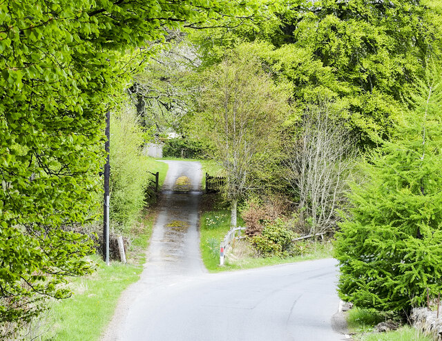
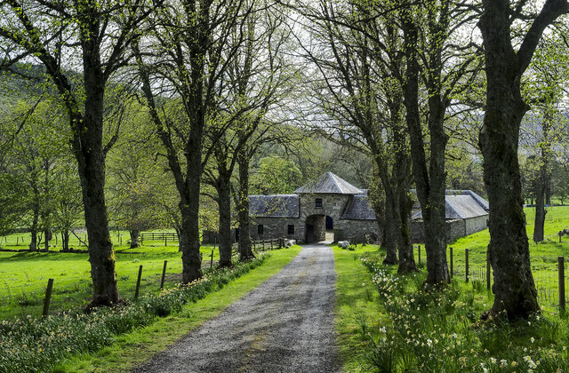
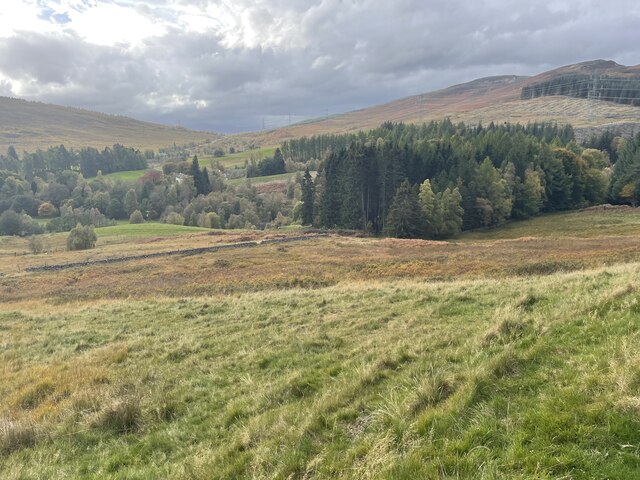
Big Wood is a majestic forest located in the heart of Perthshire, Scotland. Spanning over vast acres, this woodland area is renowned for its stunning beauty and rich biodiversity. The wood is nestled amidst the breathtaking landscapes of the Scottish Highlands, offering visitors a true escape into nature.

Big Wood is predominantly composed of native tree species such as Scots pine, oak, birch, and rowan, which create a dense canopy overhead. The forest floor is adorned with a vibrant tapestry of mosses, ferns, and wildflowers, adding to its enchanting allure. The wood is crisscrossed by numerous winding trails, allowing visitors to explore its depths and discover hidden treasures around every corner.

One of the highlights of Big Wood is its diverse wildlife population. The forest provides a sanctuary for various species, including red squirrels, roe deer, and numerous bird species such as woodpeckers and owls. Nature enthusiasts can delight in observing these creatures in their natural habitat, making it a haven for birdwatching and wildlife photography.

The wood also holds historical significance, with ancient ruins and remnants of old settlements scattered throughout its expanse. These remnants serve as a reminder of the deep-rooted connection between humans and the land.

Big Wood is a popular destination for outdoor activities such as hiking, cycling, and picnicking. Its serene atmosphere and breathtaking vistas make it an ideal spot for relaxation and rejuvenation. Whether one seeks solitude amidst nature or an adventure-filled day exploring the wilderness, Big Wood offers an unforgettable experience for all who venture within its boundaries.

If you have any feedback on the listing, please let us know in the comments section below.

Big Wood Images

Images are sourced within 2km of 56.74693/-4.0650868 or Grid Reference NN7363. Thanks to Geograph Open Source API. All images are credited.

Drumcroy Hill Now with a big clearfelled area on the south side. The summit itself is in a fine piece of old woodland.
Drumcroy Hill
Now with a big clearfelled area on the south side. The summit itself is in a fine piece of old woodland.
B847 towards Trinafour
B847 near Trinafour
B847 near Trinafour
B847 at Trinafour
B847 at Trinafour
Minor road towards Dalnacardoch
Access road for Auckleeks House The road is an approach from the B847 in Glen Errochty for the large, Auchleeks House and for other properties.
Access road for Auckleeks House
The road is an approach from the B847 in Glen Errochty for the large, Auchleeks House and for other properties.
Access road for Trinafour House The access road branching from a bend of the B847.
Access road for Trinafour House
The access road branching from a bend of the B847.
B847 heading towards Trinafour The B847 heading west on the north side of Glen Errochty.
B847 heading towards Trinafour
The B847 heading west on the north side of Glen Errochty.
Clump of trees in field with sheep This is in Glen Errochty on the north side of the Errochty Water.
Clump of trees in field with sheep
This is in Glen Errochty on the north side of the Errochty Water.
Estate road descending towards farm buildings The road is descending from the vicinity of Auchleeks House to the buildings in the image which seem to be known as Doocot Cottage, (or to contain it). To the right of the archway into the courtyard there's an OS flush bracket, No. G1084.
Estate road descending towards farm buildings
The road is descending from the vicinity of Auchleeks House to the buildings in the image which seem to be known as Doocot Cottage, (or to contain it). To the right of the archway into the courtyard there's an OS flush bracket, No. G1084.
General Wade"s Road A network of military roads, sometimes called General Wade's Military Roads, was constructed in the Scottish Highlands during the middle part of the 18th century as part of an attempt by the British Government to bring order to a part of the country which had risen up in the Jacobite rebellion of 1715.

The roads were constructed to link the Central Lowlands with a series of fortified barracks located strategically across the Highlands. Their purpose much like the network of roads constructed by the Romans more than 1,500 years earlier was to suppress and exert control over the local population. The engineered roads of the Roman period did not extend into the Highlands, which was where these later roads were constructed.

The first four of these roads were constructed in the 1720s and 1730s under the direction of General George Wade (an Anglo-Irishman) and are commonly referred to as General Wade’s Military Roads or simply as Wade’s Roads.
General Wade"s Road
A network of military roads, sometimes called General Wade's Military Roads, was constructed in the Scottish Highlands during the middle part of the 18th century as part of an attempt by the British Government to bring order to a part of the country which had risen up in the Jacobite rebellion of 1715. The roads were constructed to link the Central Lowlands with a series of fortified barracks located strategically across the Highlands. Their purpose much like the network of roads constructed by the Romans more than 1,500 years earlier was to suppress and exert control over the local population. The engineered roads of the Roman period did not extend into the Highlands, which was where these later roads were constructed. The first four of these roads were constructed in the 1720s and 1730s under the direction of General George Wade (an Anglo-Irishman) and are commonly referred to as General Wade’s Military Roads or simply as Wade’s Roads.
Deer Fence and track
Autumnal View
Autumnal View
Just about call this a layby
Boulder with an interesting OS Mark
Working the Flock The old walled pens above Trinafour are being used to work with a flock of sheep. It's too late in the year for dipping or shearing, so perhaps they are being sorted for market, or dosed with some form of medication. The Errochty Water meanders along the floor of the strath below.
Working the Flock
The old walled pens above Trinafour are being used to work with a flock of sheep. It's too late in the year for dipping or shearing, so perhaps they are being sorted for market, or dosed with some form of medication. The Errochty Water meanders along the floor of the strath below.
Trinafour Power Station This little power station generates electricity from the water channelled from Loch Errochty. It is part of the Tummel-Garry hydro electric power system.
Trinafour Power Station
This little power station generates electricity from the water channelled from Loch Errochty. It is part of the Tummel-Garry hydro electric power system.
House at Trinafour A smartly painted traditional stone house just beside the road in Trinafour.
House at Trinafour
A smartly painted traditional stone house just beside the road in Trinafour.
Show me another place!

Big Wood is located at Grid Ref: NN7363 (Lat: 56.74693, Lng: -4.0650868)

Unitary Authority: Perth and Kinross

Police Authority: Tayside

What 3 Words

///glee.lifestyle.conductor. Near Blair Atholl, Perth & Kinross

Nearby Locations

Big Wood

Related Wikis

Trinafour

Trinafour (; Scottish Gaelic: Trian a' Phùir) is a village in Perth and Kinross, Scotland, approximately 17 miles (27 km) north-west of Pitlochry, its...

Bohespic

Bohespic (Gaelic: Both Easbaig 'bishop's house') is a place near Blair Atholl in the Perth and Kinross area of Scotland. The name also appears in older...

Tummel Bridge

Tummel Bridge is a double arched hump-backed former military bridge crossing the River Tummel at Tummel Bridge, Perth & Kinross, Scotland. A Category A...

Loch Errochty

Loch Errochty is a man made freshwater loch situated within the Perth and Kinross council area at the edge of the Scottish Highlands near the Highland...

Nearby Amenities

Located within 500m of 56.74693,-4.0650868
Turning Circle
Lat/Long: 56.747691/-4.0658352
The data included in this document is from www.openstreetmap.org. The data is made available under ODbL.

Have you been to Big Wood?

Leave your review of Big Wood below (or comments, questions and feedback).