Martin Craig Plantation

Wood, Forest in Kirkcudbrightshire

Scotland

Martin Craig Plantation

Kirkstead, Kirkcudbright Now in ruins, the cottage of Kirkstead stands 350 yards to the WNW of St Michael's Kirk, of which there is now no trace. The Ordnance Survey Name Book states that the cottage was supposed to have been built on the site of the church's graveyard, hence Kirk (church) and Stead (farmhouse and its outbuildings - compare with homestead, steading etc). Two other names in the area also relate to the church: Kirkstead Bridge (44 yards to the WNW of the cottage), and St Michael's Glen (which carries a burn to the north of the church).
Kirkstead, Kirkcudbright Credit: Forrest and Jen

The Martin Craig Plantation is a picturesque woodland located in Kirkcudbrightshire, Scotland. Covering an area of approximately 200 acres, it is a popular destination for nature enthusiasts and outdoor adventurers. The plantation is situated a few miles east of the town of Kirkcudbright, amidst rolling hills and scenic countryside.

The woodland is primarily dominated by a variety of native tree species, including oak, birch, and pine, which create a diverse and vibrant ecosystem. The dense canopy provides a haven for a wide range of wildlife, such as red squirrels, roe deer, and numerous bird species.

A network of well-maintained trails meanders through the plantation, offering visitors the opportunity to explore the natural beauty of the area. These trails are suitable for both walking and cycling, with some paths also accessible to wheelchair users. Along the way, there are several picnic spots and viewpoints where visitors can rest and enjoy the tranquil surroundings.

Martin Craig Plantation is managed by the local forestry commission, ensuring the preservation of the woodland's natural integrity and beauty. The commission regularly carries out sustainable forestry practices, including selective tree felling and replanting, to maintain a healthy and balanced ecosystem.

Whether it's a leisurely stroll, a challenging hike, or a peaceful picnic, Martin Craig Plantation offers something for everyone. With its stunning scenery and abundant wildlife, it is a true gem in the Scottish countryside, providing a welcome escape from the hustle and bustle of everyday life.

If you have any feedback on the listing, please let us know in the comments section below.

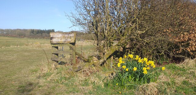
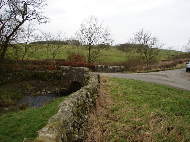
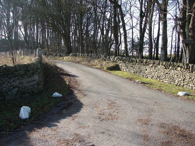
Martin Craig Plantation Images

Images are sourced within 2km of 54.831061/-3.9816102 or Grid Reference NX7250. Thanks to Geograph Open Source API. All images are credited.

Kirkstead, Kirkcudbright Now in ruins, the cottage of Kirkstead stands 350 yards to the WNW of St Michael's Kirk, of which there is now no trace. The Ordnance Survey Name Book states that the cottage was supposed to have been built on the site of the church's graveyard, hence Kirk (church) and Stead (farmhouse and its outbuildings - compare with homestead, steading etc). Two other names in the area also relate to the church: Kirkstead Bridge (44 yards to the WNW of the cottage), and St Michael's Glen (which carries a burn to the north of the church).
Kirkstead, Kirkcudbright
Now in ruins, the cottage of Kirkstead stands 350 yards to the WNW of St Michael's Kirk, of which there is now no trace. The Ordnance Survey Name Book states that the cottage was supposed to have been built on the site of the church's graveyard, hence Kirk (church) and Stead (farmhouse and its outbuildings - compare with homestead, steading etc). Two other names in the area also relate to the church: Kirkstead Bridge (44 yards to the WNW of the cottage), and St Michael's Glen (which carries a burn to the north of the church).
The Bombie Bull This bull stands guard at Bombie farm.
The Bombie Bull
This bull stands guard at Bombie farm.
Near Bombie Hill The minor road near to Bombie Hill.
Near Bombie Hill
The minor road near to Bombie Hill.
Gribdae Lane This minor road serves Gribdae Farm.
Gribdae Lane
This minor road serves Gribdae Farm.
Near to Noggie The minor road near to Noggie cottage.
Near to Noggie
The minor road near to Noggie cottage.
Near to Penbridge Cottage A minor road junction at this isolated location.
Near to Penbridge Cottage
A minor road junction at this isolated location.
Beginning of the track to Kiln Hill This remote track is used to service forestry work in the area.
Beginning of the track to Kiln Hill
This remote track is used to service forestry work in the area.
Track to the trees A forestry track through remote countryside.
Track to the trees
A forestry track through remote countryside.
At Marks Farm Rough grazing at Marks Farm.
At Marks Farm
Rough grazing at Marks Farm.
Bullocks in a field near Noggie
Rough ground on Newlaw Hill Rough ground on the lower slopes of Newlaw Hill, the first trees planted as part of Newlaw Woodland are to the right hand side.
Rough ground on Newlaw Hill
Rough ground on the lower slopes of Newlaw Hill, the first trees planted as part of Newlaw Woodland are to the right hand side.
Sign for Core Path 14 The sign for core path 14 which leads to Fellcroft Loch.
Sign for Core Path 14
The sign for core path 14 which leads to Fellcroft Loch.
Kirsten's Woodland Walk An area of native woodland planted between 2004 and 2007.
Kirsten's Woodland Walk
An area of native woodland planted between 2004 and 2007.
Sign for the delightfully named tongue of Bombie
Drumboy Bridge Junction of roads to Dundrennan, Kirkcarswell and Whinnieliggate at Drumboy Bridge. The Abbey Burn flows under the bridge en route to the Solway Firth via Dundrennan Abbey.
Drumboy Bridge
Junction of roads to Dundrennan, Kirkcarswell and Whinnieliggate at Drumboy Bridge. The Abbey Burn flows under the bridge en route to the Solway Firth via Dundrennan Abbey.
Auchengool New plantation on the Auchengool estate. Auchengool House lies to the upper left of the picture, the farm and cottages to the right.
Auchengool
New plantation on the Auchengool estate. Auchengool House lies to the upper left of the picture, the farm and cottages to the right.
Castle Creavie Copse View from Castle Creavie entrance, the Drumboy-Buckland lane continues westward past the copse.
Castle Creavie Copse
View from Castle Creavie entrance, the Drumboy-Buckland lane continues westward past the copse.
Castle Creavie Entrance Entrance to Castle Creavie farm and holiday workshops.
Castle Creavie Entrance
Entrance to Castle Creavie farm and holiday workshops.
Show me another place!

Martin Craig Plantation is located at Grid Ref: NX7250 (Lat: 54.831061, Lng: -3.9816102)

Unitary Authority: Dumfries and Galloway

Police Authority: Dumfries and Galloway

What 3 Words

///skims.screeches.swung. Near Kirkcudbright, Dumfries & Galloway

Related Wikis

High Banks cup and ring markings

The High Banks cup and ring markings are a series of Neolithic or Bronze Age carvings on an outcrop of rock near High Banks farm, 3 km SE of Kirkcudbright...

Dundrennan

Dundrennan (Gaelic: Dun Droighnein) is a village Dumfries and Galloway, Scotland, about 5 miles (8 km) east of Kirkcudbright. Its population is around...

Dundrennan Abbey

Dundrennan Abbey, in Dundrennan, Scotland, near to Kirkcudbright, was a Cistercian monastery in the Romanesque architectural style, established in 1142...

Dundrennan Range

Dundrennan Range is a weapons testing range on the Solway Firth, near Kirkcudbright in Dumfries and Galloway, in south west Scotland, it is part of the...

Related Videos

Nearby Amenities

Located within 500m of 54.831061,-3.9816102
Power: pole
Lat/Long: 54.8325154/-3.9745568
Power: pole
Lat/Long: 54.831895/-3.976131
Power: pole
Lat/Long: 54.8315793/-3.9769468
Power: pole
Lat/Long: 54.8315193/-3.9778369
Power: pole
Lat/Long: 54.8314728/-3.9786485
Power: pole
Lat/Long: 54.8314386/-3.9792561
Power: pole
Lat/Long: 54.8312819/-3.9797532
Power: pole
Lat/Long: 54.8308965/-3.9806604
Power: pole
Lat/Long: 54.8307337/-3.9815484
Power: pole
Lat/Long: 54.8304658/-3.9823705
Power: pole
Lat/Long: 54.8302382/-3.9837005
Power: pole
Lat/Long: 54.8300558/-3.9847712
Power: pole
Lat/Long: 54.8298906/-3.9858185
Power: pole
Lat/Long: 54.8295419/-3.9873014
Power: pole
Lat/Long: 54.8293143/-3.9882893
Power: pole
Lat/Long: 54.8323685/-3.9776755
Power: pole
Lat/Long: 54.8328042/-3.9777074
Power: pole
Lat/Long: 54.8332116/-3.9777392
The data included in this document is from www.openstreetmap.org. The data is made available under ODbL.

Have you been to Martin Craig Plantation?

Leave your review of Martin Craig Plantation below (or comments, questions and feedback).