Garden Wood

Wood, Forest in Stirlingshire

Scotland

Garden Wood

Foot of the steps Where the carse meets the first steep section of the Gargunnock Hills. The scarp is stepped with successive lava flows.
Foot of the steps Credit: Richard Webb

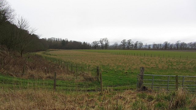
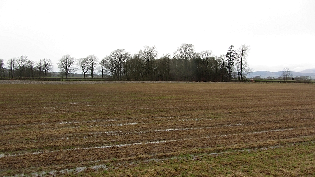
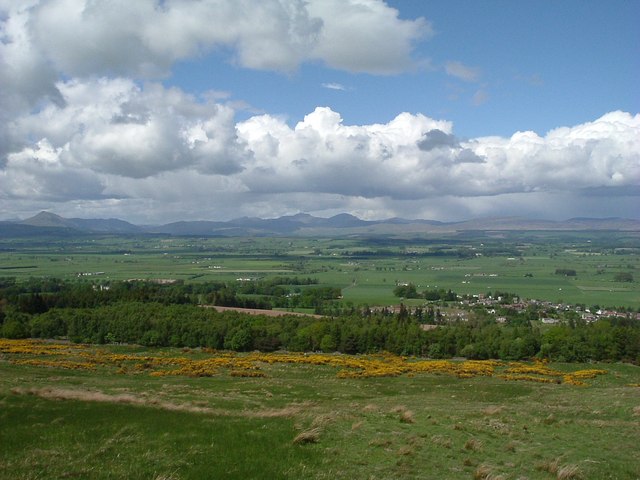
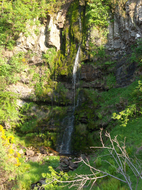
Garden Wood is a sprawling forest located in Stirlingshire, Scotland. Covering an area of approximately 200 acres, this woodland is a haven for nature lovers and hikers alike. The wood is situated on the eastern slopes of the Campsie Fells, providing stunning panoramic views of the surrounding landscape.

The forest is predominantly made up of native broadleaf trees, including oak, birch, and beech, which create a rich and diverse habitat for various wildlife species. Visitors can expect to encounter a range of animals, such as red squirrels, roe deer, and a variety of bird species, including woodpeckers and owls.

Garden Wood is crisscrossed with a network of well-maintained trails, catering to different levels of fitness and experience. These paths wind through the woodland, allowing visitors to explore its many hidden gems, including picturesque glens, babbling streams, and tranquil ponds. For those seeking a longer adventure, the wood is also connected to a larger network of paths that extend into the surrounding countryside.

The forest is managed by the local council, who work tirelessly to preserve its natural beauty while providing a safe and enjoyable experience for visitors. They periodically organize guided walks and educational events, offering visitors the opportunity to learn more about the wood's history, flora, and fauna.

Garden Wood is a true gem in Stirlingshire, offering a peaceful retreat from the hustle and bustle of everyday life. Whether you are a keen hiker, wildlife enthusiast, or simply seeking solace in nature, this enchanting woodland is sure to captivate your senses and leave you with a lasting impression.

If you have any feedback on the listing, please let us know in the comments section below.

Garden Wood Images

Images are sourced within 2km of 56.126108/-4.0738555 or Grid Reference NS7194. Thanks to Geograph Open Source API. All images are credited.

Foot of the steps Where the carse meets the first steep section of the Gargunnock Hills. The scarp is stepped with successive lava flows.
Foot of the steps
Where the carse meets the first steep section of the Gargunnock Hills. The scarp is stepped with successive lava flows.
Stubble, Gargunnock The field is a bit wet after a day of rain. This is the flat carse land beside the Forth.
Stubble, Gargunnock
The field is a bit wet after a day of rain. This is the flat carse land beside the Forth.
Turning for Gargunnock From A811 east
Turning for Gargunnock
From A811 east
Gargunnock junction with A811 Junction with A811. The road to Gargunnock (behind photographer), and farm road to Nether Carse.
Gargunnock junction with A811
Junction with A811. The road to Gargunnock (behind photographer), and farm road to Nether Carse.
Turning for Nether Carse and Patrickston
Pasture and mown meadow near Gargunnock From the A811 at the crossroads west of Gargunnock.
Pasture and mown meadow near Gargunnock
From the A811 at the crossroads west of Gargunnock.
Below the Gargunnock Hills
Bield Farm Bield Farm at bend in road towards Gargunock from the road that runs from the A811
Bield Farm
Bield Farm at bend in road towards Gargunock from the road that runs from the A811
East Lodge East Lodge, Leckie, was originally the gate lodge for Watson House. It has no been extended and is a private family home.
East Lodge
East Lodge, Leckie, was originally the gate lodge for Watson House. It has no been extended and is a private family home.
Open hillside below Gargunnock Crags Looking over Flanders Moss toward the twin peaks of Ben Vorlich and Stuc a'Chroin in centre and Ben Ledi to the left. The village of Gargunnock is to the right of the photo. Flanders Moss is a vast area of around 50 square miles forming the flood plain for the River Forth. Once entirely bog it was drained and is now rich arable farmland.
Open hillside below Gargunnock Crags
Looking over Flanders Moss toward the twin peaks of Ben Vorlich and Stuc a'Chroin in centre and Ben Ledi to the left. The village of Gargunnock is to the right of the photo. Flanders Moss is a vast area of around 50 square miles forming the flood plain for the River Forth. Once entirely bog it was drained and is now rich arable farmland.
Watson House Looking across the fields to Watson house.
Watson House
Looking across the fields to Watson house.
Approaching Gargunnock Approaching Gargunnock through the Leckie estate.
Approaching Gargunnock
Approaching Gargunnock through the Leckie estate.
Sweeping avenue to Watson House
Entrance to Leckie House
Wall beside Whitehill Wood
A811 by Dasherhead Farm
Garunnock from the A811 Garunnock is a small village at the foot of the Gargunnock Hills, part of the Campsie Fells
Garunnock from the A811
Garunnock is a small village at the foot of the Gargunnock Hills, part of the Campsie Fells
Gargunnock House Gargonnock House owned & let by The Landmark Trust. 11 of us stayed here in Feb 2000
Gargunnock House
Gargonnock House owned & let by The Landmark Trust. 11 of us stayed here in Feb 2000
Show me another place!

Garden Wood is located at Grid Ref: NS7194 (Lat: 56.126108, Lng: -4.0738555)

Unitary Authority: Stirling

Police Authority: Forth Valley

What 3 Words

///pothole.luck.array. Near Kippen, Stirling

Related Wikis

Gargunnock railway station

Gargunnock railway station served the village of Gargunnock, Stirling, Scotland, from 1856 to 1959 on the Forth and Clyde Junction Railway. == History... ==

Gargunnock

Gargunnock is a small village in the Stirling council area with an active community trust, seven miles (eleven kilometres) west of Stirling, in Scotland...

Stirling (UK Parliament constituency)

Stirling is a county constituency of the House of Commons of the Parliament of the United Kingdom. It elects one Member of Parliament (MP) by the first...

Downie's Loup

Downie's Loup is a waterfall of Scotland located near the village of Gargunnock. == See also == Waterfalls of Scotland == References ==

Nearby Amenities

Located within 500m of 56.126108,-4.0738555
Gargunnock House Gardens
Access: customers
Fee: yes
Leisure: garden
Phone: +44 1786 860392
Website: http://gargunnockgardens.co.uk/wp/
Lat/Long: 56.1256582/-4.0689753
Entrance: yes
Lat/Long: 56.1269704/-4.0719472
Bench
Lat/Long: 56.125913/-4.0798748
Bench
Lat/Long: 56.125984/-4.0800022
Waste Basket
Waste: dog_excrement
Lat/Long: 56.1230425/-4.0752725
Barrier: cattle_grid
Lat/Long: 56.1237519/-4.0786553
Power: pole
Lat/Long: 56.1298747/-4.0707055
Power: pole
Lat/Long: 56.1298526/-4.0713561
Power: pole
Lat/Long: 56.1298222/-4.0722471
Power: pole
Lat/Long: 56.1297838/-4.0730922
Power: pole
Lat/Long: 56.1297465/-4.0739268
Power: pole
Lat/Long: 56.1296998/-4.0750333
Power: pole
Lat/Long: 56.1296451/-4.0761357
Power: pole
Lat/Long: 56.1295903/-4.0772192
Power: pole
Lat/Long: 56.1293637/-4.0783571
Power: pole
Lat/Long: 56.129216/-4.0792587
Power: pole
Lat/Long: 56.1293326/-4.069028
Power: pole
Lat/Long: 56.1287008/-4.0689024
Power: pole
Lat/Long: 56.1280666/-4.068779
Power: pole
Lat/Long: 56.127423/-4.0686389
Power: pole
Lat/Long: 56.1267958/-4.0685301
Power: pole
Lat/Long: 56.1299516/-4.0713602
Power: pole
Lat/Long: 56.1233133/-4.0768594
Power: pole
Lat/Long: 56.1235441/-4.0768511
Power: pole
Lat/Long: 56.1235733/-4.076849
Power: pole
Lat/Long: 56.1240478/-4.0768783
Power: pole
Lat/Long: 56.1245282/-4.076872
Power: pole
Lat/Long: 56.1249409/-4.0769389
Power: pole
Lat/Long: 56.12537/-4.0769891
Power: pole
Lat/Long: 56.1261406/-4.0773907
Power: pole
Lat/Long: 56.1265102/-4.0775141
Power: pole
Lat/Long: 56.1268005/-4.0775978
Power: pole
Lat/Long: 56.1274429/-4.0777882
Power: pole
Lat/Long: 56.1280747/-4.077966
Power: pole
Lat/Long: 56.1287229/-4.0781647
Power: pole
Lat/Long: 56.1293373/-4.0783488
Power: pole
Lat/Long: 56.1264554/-4.0787587
Power: pole
Lat/Long: 56.1221867/-4.0706862
Power: pole
Lat/Long: 56.1218532/-4.071914
The data included in this document is from www.openstreetmap.org. The data is made available under ODbL.

Have you been to Garden Wood?

Leave your review of Garden Wood below (or comments, questions and feedback).