Carlton

Settlement in Yorkshire Richmondshire

England

Carlton

East Scrafton Moor The moors on the south side of Coverdale seen from Town Head Cottage above Melmerby
East Scrafton Moor Credit: Nick Wright

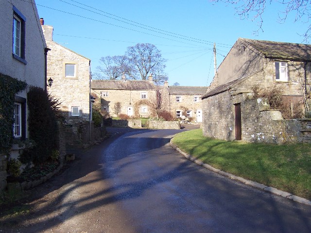
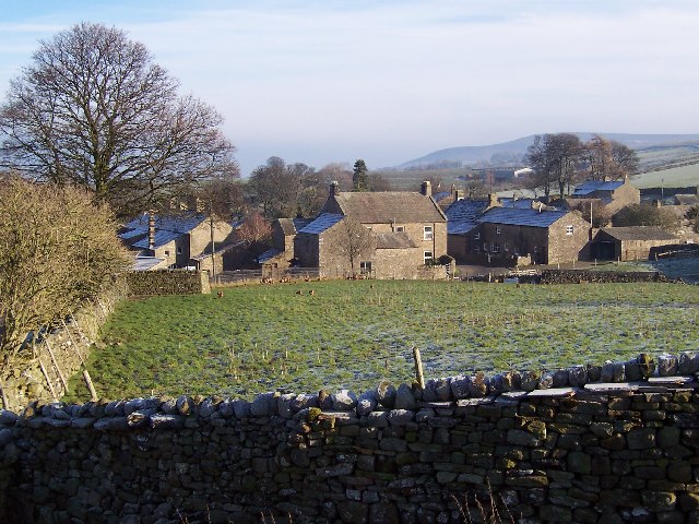
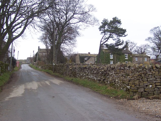
Carlton is a small village located in the county of Yorkshire, England. Situated in the heart of the Yorkshire Dales National Park, it is known for its picturesque beauty and tranquil atmosphere. With a population of approximately 500 residents, Carlton offers a close-knit community feel.

The village is surrounded by rolling hills, lush green meadows, and charming stone-built houses, giving it a quintessentially English countryside ambiance. It is a popular destination for nature lovers, hikers, and outdoor enthusiasts, who are drawn to the stunning landscapes and numerous walking trails that crisscross the area.

Although small, Carlton boasts a few amenities to cater to its residents and visitors. There is a village pub that serves traditional British cuisine and local ales, offering a cozy gathering spot for locals and a warm welcome to visitors. Additionally, there is a village hall that hosts various community events throughout the year, including fairs, concerts, and cultural gatherings.

The village also benefits from its proximity to larger towns such as Skipton and Harrogate, which provide a wider range of amenities and services. Furthermore, the vibrant city of Leeds is just a short drive away, offering residents access to a bustling urban lifestyle.

Overall, Carlton, Yorkshire is a quaint and idyllic village that offers a peaceful retreat from the busy city life. With its stunning natural surroundings and strong sense of community, it is a place that attracts those seeking a slower-paced and more rural way of life.

If you have any feedback on the listing, please let us know in the comments section below.

Carlton Images

Images are sourced within 2km of 54.256591/-1.901726 or Grid Reference SE0684. Thanks to Geograph Open Source API. All images are credited.

East Scrafton Moor The moors on the south side of Coverdale seen from Town Head Cottage above Melmerby
East Scrafton Moor
The moors on the south side of Coverdale seen from Town Head Cottage above Melmerby
Cottages at West Scrafton A view across the head of Caygill to cottages on the far side.
Cottages at West Scrafton
A view across the head of Caygill to cottages on the far side.
Telephone kiosk and green at West Scrafton A very small Coverdale village with a suitably small green, at one side of which is the telephone kiosk.
Telephone kiosk and green at West Scrafton
A very small Coverdale village with a suitably small green, at one side of which is the telephone kiosk.
The post box in West Scrafton A 'VR' postbox set into the wall of a barn in West Scrafton.
The post box in West Scrafton
A 'VR' postbox set into the wall of a barn in West Scrafton.
Methodist chapel, West Scrafton Stone built chapel dated 1866 in West Scrafton.
Methodist chapel, West Scrafton
Stone built chapel dated 1866 in West Scrafton.
West Scrafton The view over the village from the moor track. Penhill dominates the distant skyline.
West Scrafton
The view over the village from the moor track. Penhill dominates the distant skyline.
Trees in Great Gill The moor above West Scrafton is largely treeless, but they are found along the minor valley of Great Gill.
Trees in Great Gill
The moor above West Scrafton is largely treeless, but they are found along the minor valley of Great Gill.
Great Gill A sizeable beck flows down the gill, passes through West Scrafton in a gorge and empties into the River Cover.
Great Gill
A sizeable beck flows down the gill, passes through West Scrafton in a gorge and empties into the River Cover.
Bridleway to West Scrafton Walking uphill from the village, this bridleway makes a promising start, being well defined and relatively well drained, but once on the moor top and at the parish boundary the route disappears into heather and bog.
Bridleway to West Scrafton
Walking uphill from the village, this bridleway makes a promising start, being well defined and relatively well drained, but once on the moor top and at the parish boundary the route disappears into heather and bog.
West Scrafton Looking across Coverdale, with the village of Carlton beyond on the far side of the dale.
West Scrafton
Looking across Coverdale, with the village of Carlton beyond on the far side of the dale.
West Scrafton and Coverdale Looking west from the track heading south from the bridge.
West Scrafton and Coverdale
Looking west from the track heading south from the bridge.
Looking up to Great Roova Crags Through pasture to the south of West Scrafton, in Coverdale.
Looking up to Great Roova Crags
Through pasture to the south of West Scrafton, in Coverdale.
Heading for Great Roova Crags On a superb Saturday afternoon in October, walkers follow the path south from West Scrafton.
Heading for Great Roova Crags
On a superb Saturday afternoon in October, walkers follow the path south from West Scrafton.
Carlton Moor Taken from just south of West Scrafton, in Coverdale.
Carlton Moor
Taken from just south of West Scrafton, in Coverdale.
Bridge Cottage, West Scrafton In the gloaming at the end of a stunning (and unexpectedly) beautiful October day.
Bridge Cottage, West Scrafton
In the gloaming at the end of a stunning (and unexpectedly) beautiful October day.
Tatty barn at West Scrafton It appears that the Pennine weather has been at work on this barn close to West Scrafton village.
Tatty barn at West Scrafton
It appears that the Pennine weather has been at work on this barn close to West Scrafton village.
Old hedgerow trees A line of mature trees across a field at West Scrafton. Close examination reveals that they all have horizontal branches low down, indicating that they were once laid as a hedge.
Old hedgerow trees
A line of mature trees across a field at West Scrafton. Close examination reveals that they all have horizontal branches low down, indicating that they were once laid as a hedge.
Footpath at West Scrafton Footpath dropping downhill towards the River Cover at West Scrafton. The ladder stile ahead is just on the grid line.
Footpath at West Scrafton
Footpath dropping downhill towards the River Cover at West Scrafton. The ladder stile ahead is just on the grid line.
Show me another place!

Carlton is located at Grid Ref: SE0684 (Lat: 54.256591, Lng: -1.901726)

Division: North Riding

Administrative County: North Yorkshire

District: Richmondshire

Police Authority: North Yorkshire

What 3 Words

///mondays.bedding.tightest. Near Leyburn, North Yorkshire

Related Wikis

Carlton, Richmondshire

Carlton is a village in the civil parish of Carlton Town in the Richmondshire district of North Yorkshire, England. According to the 2011 Census it had...

Coverdale, North Yorkshire

Coverdale is a dale in the far east of the Yorkshire Dales, North Yorkshire, England. It takes its name from the River Cover, a tributary of the River...

West Scrafton

West Scrafton is a village and civil parish in Coverdale in the Yorkshire Dales, England. It is located 4 miles (6.4 km) south west of Leyburn. It falls...

Melmerby in Coverdale

Melmerby is a village and civil parish in North Yorkshire, England. It lies in Coverdale in the Yorkshire Dales about 3 miles (4.8 km) south-west of Leyburn...

Nearby Amenities

Located within 500m of 54.256591,-1.901726
Carlton
Is In Country Code: GB
Is In County: North Yorkshire
Is In Municipality: Richmondshire
Place: village
Source: NPE
Wikidata: Q2732060
Lat/Long: 54.2573691/-1.9041879
Barrier: stile
Lat/Long: 54.257268/-1.9013445
Castle Motte
Historic: castle
Lat/Long: 54.2574545/-1.8975227
Post Box
Post Box Type: lamp
Lat/Long: 54.2575832/-1.8999622
Telephone
Booth: K6
Covered: booth
Lat/Long: 54.2577367/-1.9022421
Barrier: stile
Lat/Long: 54.2552069/-1.9032716
Ford: yes
Lat/Long: 54.2584106/-1.9031082
Power: pole
Lat/Long: 54.2585117/-1.9000849
Power: pole
Lat/Long: 54.2583206/-1.9012876
Power: pole
Lat/Long: 54.2581899/-1.9021193
Power: pole
Lat/Long: 54.2578563/-1.9042387
Power: pole
Lat/Long: 54.2576296/-1.9057311
Power: pole
Lat/Long: 54.2573115/-1.9077189
Power: pole
Lat/Long: 54.2562379/-1.9083837
Town Head Farm
Place: farm
Lat/Long: 54.2563906/-1.9066526
Power: pole
Lat/Long: 54.2522517/-1.8999072
Power: pole
Lat/Long: 54.2555167/-1.9071592
Power: pole
Lat/Long: 54.2546385/-1.905722
Power: pole
Lat/Long: 54.2537909/-1.9043305
Power: pole
Lat/Long: 54.2532605/-1.9028089
Power: pole
Lat/Long: 54.2527741/-1.9014106
Power: pole
Lat/Long: 54.2589147/-1.8983241
Power: pole
Lat/Long: 54.2593251/-1.8966429
The data included in this document is from www.openstreetmap.org. The data is made available under ODbL.

Have you been to Carlton?

Leave your review of Carlton below (or comments, questions and feedback).