Clachan Wood

Wood, Forest in Stirlingshire

Scotland

Clachan Wood

Dungoil Clearfelled Dungoil, seen from the road across the north side of Lecket Hill
Dungoil Credit: Richard Webb

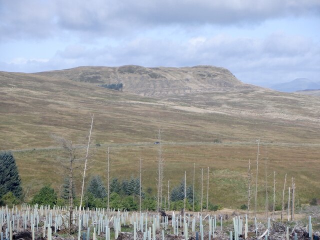
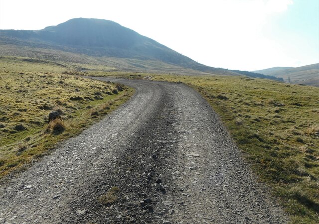
Clachan Wood is a picturesque forest located in Stirlingshire, Scotland. Situated near the village of Killearn, the wood is nestled within the beautiful countryside, offering visitors a peaceful and serene environment to explore.

Covering an area of approximately 50 acres, Clachan Wood is home to a diverse range of flora and fauna. The wood is predominantly composed of native broadleaf species, including oak, birch, and ash trees. These towering trees provide a dense canopy, creating a cool and shaded atmosphere even on the warmest of days.

The wood is crisscrossed by a network of well-maintained footpaths, allowing visitors to wander through the forest and discover its hidden treasures. Along the paths, one can find a variety of woodland plants, such as bluebells, wood sorrel, and wild garlic, which create a vibrant carpet of color during the spring and summer months.

Wildlife enthusiasts will be delighted by the abundance of animal life within Clachan Wood. Red squirrels, roe deer, and a variety of bird species can often be spotted among the trees. The wood is also home to a number of bat species, which can be observed darting through the twilight skies at dusk.

In addition to its natural beauty, Clachan Wood is also steeped in history. Ancient ruins, including a standing stone and a burial mound, can be found within the wood, adding an air of mystery and intrigue.

Overall, Clachan Wood is a true gem in the Stirlingshire countryside, offering visitors a chance to immerse themselves in nature and discover the rich history of the area.

If you have any feedback on the listing, please let us know in the comments section below.

Clachan Wood Images

Images are sourced within 2km of 56.046841/-4.2112062 or Grid Reference NS6285. Thanks to Geograph Open Source API. All images are credited.

Dungoil Clearfelled Dungoil, seen from the road across the north side of Lecket Hill
Dungoil
Clearfelled Dungoil, seen from the road across the north side of Lecket Hill
Fintry Youth Hostel by Endrick Water, Stirling North of the Campsie Fells, this was one of Scotland's earliest hostels, opening in 1935. It was popular with weekenders from Glasgow. The hostel closed in 1981 being by then structurally unsound, and was demolished. (Details from John Martin)

Scanned from an Agfa colour slide, circa mid 1970s in August. It may not be 1975.
Fintry Youth Hostel by Endrick Water, Stirling
North of the Campsie Fells, this was one of Scotland's earliest hostels, opening in 1935. It was popular with weekenders from Glasgow. The hostel closed in 1981 being by then structurally unsound, and was demolished. (Details from John Martin) Scanned from an Agfa colour slide, circa mid 1970s in August. It may not be 1975.
Townhead Farm The Fintry Hills are behind.
Townhead Farm
The Fintry Hills are behind.
Double Craigs Impressive scarps on the southwest side of the Fintry Hills. Townhead Farm is on the right.
Double Craigs
Impressive scarps on the southwest side of the Fintry Hills. Townhead Farm is on the right.
Looking down the B822
Forestry road gate Giving access to the forestry around Dungoil (slopes rising on the left).
Forestry road gate
Giving access to the forestry around Dungoil (slopes rising on the left).
Forestry track With Dungoil in the distance.
Forestry track
With Dungoil in the distance.
Double Craigs Impressive scarps on the southwest side of the Fintry Hills.
Double Craigs
Impressive scarps on the southwest side of the Fintry Hills.
Dungoil A 424 metres summit in the Campsie Fells.
Dungoil
A 424 metres summit in the Campsie Fells.
Hamlet in the Endrick Valley The settlement is located around the bridge carrying the B818 over the Endrick Water.
Hamlet in the Endrick Valley
The settlement is located around the bridge carrying the B818 over the Endrick Water.
Townhead Farm
Townhead Farm
Driveway, Knockraich Knockraich is home to a very good cafe.
Driveway, Knockraich
Knockraich is home to a very good cafe.
Woodland, Dumgoil col Much of the plantation has been clearfelled in recent years.
Woodland, Dumgoil col
Much of the plantation has been clearfelled in recent years.
Fintry Kirk Photo taken circa 1990 (Fuji Velvia 35mm film)
Fintry Kirk
Photo taken circa 1990 (Fuji Velvia 35mm film)
Campsie Fells, prominent mound On the northern slopes of Dumgoil. The scar of the Gonachan Burn's ravine is visible across the picture and the outline of Ben Lomond can just be seen in the distance.
Campsie Fells, prominent mound
On the northern slopes of Dumgoil. The scar of the Gonachan Burn's ravine is visible across the picture and the outline of Ben Lomond can just be seen in the distance.
Campsie Fells, Boggy patch on Dungoil Fintry Hills form the background.
Campsie Fells, Boggy patch on Dungoil
Fintry Hills form the background.
Campsie Fells, Gonnachan Glen The mass of Dunkessen looms above.
Campsie Fells, Gonnachan Glen
The mass of Dunkessen looms above.
Path to Dungoil summit
Show me another place!

Clachan Wood is located at Grid Ref: NS6285 (Lat: 56.046841, Lng: -4.2112062)

Unitary Authority: Stirling

Police Authority: Forth Valley

What 3 Words

///stroke.crop.inherits. Near Balfron, Stirling

Nearby Locations

Dunkessen Clachan Wood

Related Wikis

Fintry Kirk

Fintry Kirk is in the village of Fintry in Stirlingshire, Scotland. Fintry is a Church of Scotland Parish in the Presbytery of Stirling. The kirk is located...

Fintry

Fintry is a small riverside village in Stirlingshire, central Scotland. It is located 16 miles (26 km) south-west of Stirling and around 19 miles (31 km...

Culcreuch Castle

Culcreuch Castle is a Scottish castle close to the village of Fintry, near Loch Lomond. It had been the home of the Barons of Culcreuch since 1699. In...

Fintry Castle, Stirling

Fintry Castle, was a 15th-century castle near Fintry, Stirling, Scotland. The castle was built on the northern slopes of the valley of the Endrick Water...

Nearby Amenities

Located within 500m of 56.046841,-4.2112062
Power: pole
Lat/Long: 56.0501383/-4.205913
Power: pole
Lat/Long: 56.0501489/-4.2070677
Power: pole
Lat/Long: 56.0504222/-4.2081533
Power: pole
Lat/Long: 56.0506991/-4.209264
Power: pole
Lat/Long: 56.0509782/-4.2103496
Power: pole
Lat/Long: 56.0512855/-4.211613
Ford: yes
Lat/Long: 56.0454336/-4.2081489
The data included in this document is from www.openstreetmap.org. The data is made available under ODbL.

Have you been to Clachan Wood?

Leave your review of Clachan Wood below (or comments, questions and feedback).