Galbraith Wood

Wood, Forest in Stirlingshire

Scotland

Galbraith Wood

Fintry Youth Hostel by Endrick Water, Stirling North of the Campsie Fells, this was one of Scotland's earliest hostels, opening in 1935. It was popular with weekenders from Glasgow. The hostel closed in 1981 being by then structurally unsound, and was demolished. (Details from John Martin)

Scanned from an Agfa colour slide, circa mid 1970s in August. It may not be 1975.
Fintry Youth Hostel by Endrick Water, Stirling Credit: Roger D Kidd

Galbraith Wood, located in Stirlingshire, Scotland, is a picturesque forest renowned for its natural beauty and tranquil ambiance. Spanning an area of approximately 200 hectares, it is a popular destination for nature enthusiasts, hikers, and those seeking a peaceful retreat away from the hustle and bustle of city life.

The wood is primarily composed of a diverse range of tree species, including oak, ash, birch, and pine, creating a vibrant and ever-changing landscape throughout the year. These towering trees provide a haven for numerous bird species, such as woodpeckers, tits, and finches, making it an ideal location for birdwatching enthusiasts.

Trails and pathways wind their way through the wood, offering visitors the opportunity to explore its hidden gems and discover its enchanting corners. The paths vary in difficulty, catering to all levels of fitness and mobility, and are well-maintained, ensuring a safe and enjoyable experience for all.

Galbraith Wood is also home to a rich array of wildlife, including deer, foxes, squirrels, and rabbits. These creatures can often be spotted on the forest floor or darting through the undergrowth, adding to the sense of wonder and tranquility that the wood exudes.

The wood is open to the public throughout the year and is managed by the local forestry commission. It offers ample parking facilities, picnic areas, and even designated barbecue spots for visitors to enjoy. Additionally, guided tours and educational programs are available for those interested in learning more about the wood's history, ecology, and conservation efforts.

Overall, Galbraith Wood is a true gem in the Stirlingshire region, offering visitors a captivating natural environment and an opportunity to immerse themselves in the beauty of Scotland's woodlands.

If you have any feedback on the listing, please let us know in the comments section below.

Galbraith Wood Images

Images are sourced within 2km of 56.062984/-4.2160984 or Grid Reference NS6287. Thanks to Geograph Open Source API. All images are credited.

Fintry Youth Hostel by Endrick Water, Stirling North of the Campsie Fells, this was one of Scotland's earliest hostels, opening in 1935. It was popular with weekenders from Glasgow. The hostel closed in 1981 being by then structurally unsound, and was demolished. (Details from John Martin)

Scanned from an Agfa colour slide, circa mid 1970s in August. It may not be 1975.
Fintry Youth Hostel by Endrick Water, Stirling
North of the Campsie Fells, this was one of Scotland's earliest hostels, opening in 1935. It was popular with weekenders from Glasgow. The hostel closed in 1981 being by then structurally unsound, and was demolished. (Details from John Martin) Scanned from an Agfa colour slide, circa mid 1970s in August. It may not be 1975.
Double Craigs Impressive scarps on the southwest side of the Fintry Hills. Townhead Farm is on the right.
Double Craigs
Impressive scarps on the southwest side of the Fintry Hills. Townhead Farm is on the right.
Double Craigs Impressive scarps on the southwest side of the Fintry Hills.
Double Craigs
Impressive scarps on the southwest side of the Fintry Hills.
Driveway, Knockraich Knockraich is home to a very good cafe.
Driveway, Knockraich
Knockraich is home to a very good cafe.
Moorland south of Stronend Fintry Hills
Moorland south of Stronend
Fintry Hills
Plateau, Fintry Hills
Tussocks, Fintry Hills Rough going south of Stronend.
Tussocks, Fintry Hills
Rough going south of Stronend.
Fence and view of the Campsie Fells From above Fintry.
Fence and view of the Campsie Fells
From above Fintry.
Fence, Fintry Hills
Fence, Fintry Hills
Fintry Kirk Photo taken circa 1990 (Fuji Velvia 35mm film)
Fintry Kirk
Photo taken circa 1990 (Fuji Velvia 35mm film)
Scrub vegetation on slope east of B822 Rough grass and some scrub-like vegetation on the slope which rises ultimately to rock bands below Stronend via an intermediate location named as Skiddaw.
Scrub vegetation on slope east of B822
Rough grass and some scrub-like vegetation on the slope which rises ultimately to rock bands below Stronend via an intermediate location named as Skiddaw.
Low Bridge, B818 Takes the Fintry to Denny Road  across Endrick Water.
Low Bridge, B818
Takes the Fintry to Denny Road across Endrick Water.
Endrick Water, Low Bridge For view in another season see <a href="https://www.geograph.org.uk/photo/1198189">NS6386 : Endrick Water</a>.
Endrick Water, Low Bridge
For view in another season see NS6386 : Endrick Water.
Bogside under Skiddaw Flat land in Strathendrick contrasts with the trap hills  of the Fintry-Gargunnock hills.  Skiddaw is the profile of one of the horizontal lava beds.
Bogside under Skiddaw
Flat land in Strathendrick contrasts with the trap hills of the Fintry-Gargunnock hills. Skiddaw is the profile of one of the horizontal lava beds.
Fintry Westward along Main Street.  Unusually there was some evidence of jubilee celebrations here.
Fintry
Westward along Main Street. Unusually there was some evidence of jubilee celebrations here.
Farmland in Strathendrick Flat grassland west of Fintry.
Farmland in Strathendrick
Flat grassland west of Fintry.
Glenboig Wood Birch woods near Fintry. Birch woods without very old trees are often former farmland.
Glenboig Wood
Birch woods near Fintry. Birch woods without very old trees are often former farmland.
Fintry Road Junction Looking along the B822, the Crow Road from Lennoxtown towards the junction where the B822 continues to the right to Kippen and the B818 leads straight on to Killearn and Balfron.
Fintry Road Junction
Looking along the B822, the Crow Road from Lennoxtown towards the junction where the B822 continues to the right to Kippen and the B818 leads straight on to Killearn and Balfron.
Show me another place!

Galbraith Wood is located at Grid Ref: NS6287 (Lat: 56.062984, Lng: -4.2160984)

Unitary Authority: Stirling

Police Authority: Forth Valley

What 3 Words

///streetcar.florists.evaded. Near Balfron, Stirling

Nearby Locations

Galbraith Wood

Related Wikis

Culcreuch Castle

Culcreuch Castle is a Scottish castle close to the village of Fintry, near Loch Lomond. It had been the home of the Barons of Culcreuch since 1699. In...

Fintry

Fintry is a small riverside village in Stirlingshire, central Scotland. It is located 16 miles (26 km) south-west of Stirling and around 19 miles (31 km...
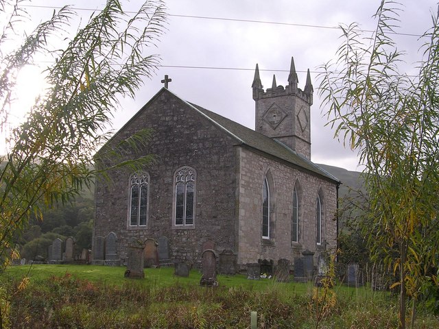
Fintry Kirk

Fintry Kirk is in the village of Fintry in Stirlingshire, Scotland. Fintry is a Church of Scotland Parish in the Presbytery of Stirling. The kirk is located...
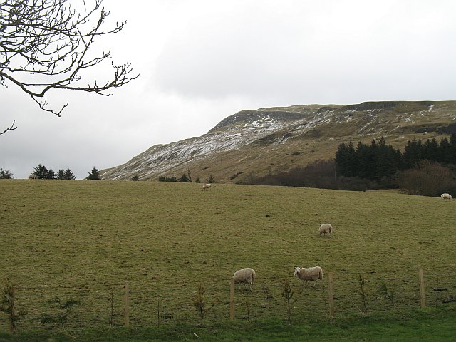
Stronend

Stronend (511 m) is the highest peak of the Fintry Hills in Stirlingshire, Scotland. Standing above the village of Fintry, it provides excellent views...

Nearby Amenities

Located within 500m of 56.062984,-4.2160984
Culcreuch Castle Hotel
Source: survey
Tourism: hotel
Wheelchair: limited
Lat/Long: 56.0618132/-4.2167247
Culcreuch Castle Arboretum
Leaf Type: mixed
Natural: wood
Lat/Long: 56.0625259/-4.2168605
Power: pole
Lat/Long: 56.0611888/-4.2229869
Power: pole
Lat/Long: 56.0606831/-4.2223321
Power: pole
Lat/Long: 56.0601903/-4.2217046
Power: pole
Lat/Long: 56.0597173/-4.2210708
Power: pole
Lat/Long: 56.0600934/-4.2202906
Power: pole
Lat/Long: 56.0604577/-4.2195815
Power: pole
Lat/Long: 56.0609132/-4.2186235
Power: pole
Lat/Long: 56.0606446/-4.2225581
Power: pole
Lat/Long: 56.060856/-4.2218615
Power: pole
Lat/Long: 56.0610825/-4.2210855
The data included in this document is from www.openstreetmap.org. The data is made available under ODbL.

Have you been to Galbraith Wood?

Leave your review of Galbraith Wood below (or comments, questions and feedback).