Black Wood

Wood, Forest in Inverness-shire

Scotland

Black Wood

Ruined village, Druim an Aird The remains of a settlement comprising 10 buildings, 3 enclosures, a corn drying kiln and an old field wall. The date of abandonment is not known and it is believed that the menfolk lost their lives in a snowstorm when returning from a wedding. (From the nearby information board).
Ruined village, Druim an Aird Credit: Jim Barton

The requested URL returned error: 429 Too Many Requests

If you have any feedback on the listing, please let us know in the comments section below.

Black Wood Images

Images are sourced within 2km of 56.993012/-4.3450717 or Grid Reference NN5791. Thanks to Geograph Open Source API. All images are credited.

Ruined village, Druim an Aird The remains of a settlement comprising 10 buildings, 3 enclosures, a corn drying kiln and an old field wall. The date of abandonment is not known and it is believed that the menfolk lost their lives in a snowstorm when returning from a wedding. (From the nearby information board).
Ruined village, Druim an Aird
The remains of a settlement comprising 10 buildings, 3 enclosures, a corn drying kiln and an old field wall. The date of abandonment is not known and it is believed that the menfolk lost their lives in a snowstorm when returning from a wedding. (From the nearby information board).
Entrance to ruined village, Druim an Aird The gate and information board for the village ruins in Strathmashie Forest.
The remains comprise 10 buildings, 3 enclosures, a corn drying kiln and an old field wall. The date of abandonment is not known and it is believed that the menfolk lost their lives in a snowstorm when returning from a wedding. (From the nearby information board).
Entrance to ruined village, Druim an Aird
The gate and information board for the village ruins in Strathmashie Forest. The remains comprise 10 buildings, 3 enclosures, a corn drying kiln and an old field wall. The date of abandonment is not known and it is believed that the menfolk lost their lives in a snowstorm when returning from a wedding. (From the nearby information board).
Ruined dwellings, Druim an Aird Stones covered with moss and lichen on the corner of one of the village houses.

The remains comprise 10 buildings, 3 enclosures, a corn drying kiln and an old field wall. The date of abandonment is not known and it is believed that the menfolk lost their lives in a snowstorm when returning from a wedding (from the nearby information board).
Ruined dwellings, Druim an Aird
Stones covered with moss and lichen on the corner of one of the village houses. The remains comprise 10 buildings, 3 enclosures, a corn drying kiln and an old field wall. The date of abandonment is not known and it is believed that the menfolk lost their lives in a snowstorm when returning from a wedding (from the nearby information board).
Track descending Druim an Aird The forest track descending from the site of the abandoned village. Note the snow patches on the high ground of the Creag Meagaidh range ahead.
Track descending Druim an Aird
The forest track descending from the site of the abandoned village. Note the snow patches on the high ground of the Creag Meagaidh range ahead.
Trees on a knoll
Trees on a knoll
Spey Reservoir
Spey Reservoir
River Pattack Waterfall on the River Pattack.
River Pattack
Waterfall on the River Pattack.
Road beside Spey Dam The Spey has been dammed here so that water can be fed into the Glen Spean catchment for electricity generation. The power is used for aluminium smelting at Fort William.
Road beside Spey Dam
The Spey has been dammed here so that water can be fed into the Glen Spean catchment for electricity generation. The power is used for aluminium smelting at Fort William.
Spey Reservoir
Spey Reservoir
Fàradh Dubh Wooded hillside above Spey Dam.
Fàradh Dubh
Wooded hillside above Spey Dam.
Ruin, Shirrabeg Beside the Spey Reservoir.
Ruin, Shirrabeg
Beside the Spey Reservoir.
Garva Bridge to Laggan Road Passing Shirrabeg.
Garva Bridge to Laggan Road
Passing Shirrabeg.
Foot of Carn Bàn Dense birches on the flanks of a fine ridge.
Foot of Carn Bàn
Dense birches on the flanks of a fine ridge.
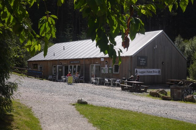
Cafe, Wolftrax New building at the Laggan trail centre.  It replaces <a href="https://www.geograph.org.uk/photo/2256004">NN5992 : Cafe, Wolftrax</a>.
Cafe, Wolftrax
New building at the Laggan trail centre. It replaces NN5992 : Cafe, Wolftrax.
Wolftrax car park The trail centre at Laggan.  Looking towards the site of the old cafe building, now replaced.
Wolftrax car park
The trail centre at Laggan. Looking towards the site of the old cafe building, now replaced.
Waterfall on the River Pattack One of a number of waterfalls on the River Pattack, this one is just off the A86.
Waterfall on the River Pattack
One of a number of waterfalls on the River Pattack, this one is just off the A86.
The new cafe, Wolftrax Laggan Community Cafe at the mountain bike trail centre.
The new cafe, Wolftrax
Laggan Community Cafe at the mountain bike trail centre.
Start banner, Wolftrax Laggan community woodlands.
Start banner, Wolftrax
Laggan community woodlands.
Show me another place!

Black Wood is located at Grid Ref: NN5791 (Lat: 56.993012, Lng: -4.3450717)

Unitary Authority: Highland

Police Authority: Highlands and Islands

What 3 Words

///mermaids.shirtless.dumplings. Near Newtonmore, Highland

Nearby Locations

Black Wood

Related Wikis

Dùn dà Làmh

Dùn dà Làmh is a Pictish now ruined hill fort near Laggan in the Scottish Highlands. It became a scheduled monument in 1986, with an extension to the protected...

Falls of Pattack

Falls of Pattack is a waterfall in the Scottish Highlands' Cairngorm National Park. The falls are on the River Pattack, about 2 km south of the A86 road...

Kinloch Laggan

Kinloch Laggan (Scottish Gaelic: Ceann Loch Lagain) is a hamlet located at the head of Loch Laggan in Newtonmore, Inverness-shire, Scottish Highlands...

Laggan, Badenoch

Laggan (Gaelic: Lagan ) is a village in Badenoch, in the Highland region of Scotland. It is beside the River Spey, about 10 km west of Newtonmore. The...

Nearby Amenities

Located within 500m of 56.993012,-4.3450717
Turning Circle
Lat/Long: 56.9906328/-4.3398979
Power: pole
Lat/Long: 56.9891921/-4.3431227
Power: pole
Lat/Long: 56.9889038/-4.3446031
Power: pole
Lat/Long: 56.9892782/-4.3452181
Power: pole
Lat/Long: 56.9890273/-4.3469909
Power: pole
Lat/Long: 56.9893148/-4.3496442
Power: pole
Lat/Long: 56.9897753/-4.3498105
Power: pole
Lat/Long: 56.9904957/-4.3500979
Power: pole
Lat/Long: 56.99099/-4.349503
Power: pole
Lat/Long: 56.9914221/-4.3489502
Power: pole
Lat/Long: 56.9918789/-4.348105
The data included in this document is from www.openstreetmap.org. The data is made available under ODbL.

Have you been to Black Wood?

Leave your review of Black Wood below (or comments, questions and feedback).