Cappercleuch

Settlement in Peeblesshire

Scotland

Cappercleuch

St Mary's Loch Looking across to Cappercleuch.
St Mary's Loch Credit: Gordon Brown

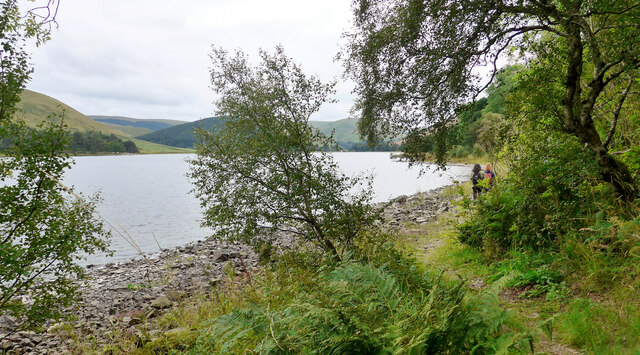
Cappercleuch is a small village located in the county of Peeblesshire, in the Scottish Borders region of Scotland. Situated in the southern part of the country, it is nestled within a picturesque valley surrounded by rolling hills and lush greenery.

The village is known for its scenic beauty and tranquil atmosphere, making it an ideal destination for those seeking a peaceful retreat. Cappercleuch is situated near the famous Grey Mare's Tail waterfall, a breathtaking natural wonder that attracts visitors from far and wide.

Despite its small size, Cappercleuch offers a few amenities for its residents and visitors. There is a local pub that serves traditional Scottish cuisine and beverages, providing a cozy gathering spot for locals and tourists alike. The village is also home to a small convenience store, ensuring that basic necessities are easily accessible to the community.

Cappercleuch is surrounded by numerous walking and hiking trails, making it an excellent base for outdoor enthusiasts. The nearby hills and forests offer opportunities for exploration and adventure, with breathtaking views of the surrounding countryside.

The village is well-connected to other parts of Peeblesshire and the wider region through a network of roads, making it easily accessible by car. Public transportation options, however, are limited, with infrequent bus services connecting Cappercleuch to nearby towns and villages.

Overall, Cappercleuch offers a peaceful and idyllic setting, perfect for those seeking a retreat in the beautiful Scottish countryside.

If you have any feedback on the listing, please let us know in the comments section below.

Cappercleuch Images

Images are sourced within 2km of 55.497099/-3.2148277 or Grid Reference NT2323. Thanks to Geograph Open Source API. All images are credited.

St Mary's Loch Looking across to Cappercleuch.
St Mary's Loch
Looking across to Cappercleuch.
Looking over St Mary's Loch to Rodono House
Sculpture by St Mary's Loch This is part of Matt Baker's sculpture "Shinglehook".  This is one of the original oak anchors
Sculpture by St Mary's Loch
This is part of Matt Baker's sculpture "Shinglehook". This is one of the original oak anchors
On the Ring of the Loch walk around St Mary's Loch
War memorial at the road junction The minor road up to the Megget Reservoir and Talla meets the A708 here.
War memorial at the road junction
The minor road up to the Megget Reservoir and Talla meets the A708 here.
The A708 crosses the Megget Water St Mary's Loch is just visible in the distance.
The A708 crosses the Megget Water
St Mary's Loch is just visible in the distance.
On the Ring of the Loch walk around St Mary's Loch At this point there is just room for a path between the A708 and St Mary's Loch itself.
On the Ring of the Loch walk around St Mary's Loch
At this point there is just room for a path between the A708 and St Mary's Loch itself.
On the Ring of the Loch walk around St Mary's Loch At this point the path follows the shore of the loch closely.  If the water level is high walking on the road would be required.  After the period of drought just experienced, this is not a problem here.
On the Ring of the Loch walk around St Mary's Loch
At this point the path follows the shore of the loch closely. If the water level is high walking on the road would be required. After the period of drought just experienced, this is not a problem here.
Large boathouse by St Mary's Loch
A signpost at Henderland This lichen-covered signpost giving directions to Cockburn’s Grave at Chapelhope is on the north side of the road at Henderland. For more information on Cockburn’s Tomb, see <a href="https://www.geograph.org.uk/photo/1257004">NT2323 : An information plaque at Cockburn's Tomb</a> and <a href="https://www.geograph.org.uk/photo/6429365">NT2323 : Cockburn's Tombe on Chapel Knowe</a>.
A signpost at Henderland
This lichen-covered signpost giving directions to Cockburn’s Grave at Chapelhope is on the north side of the road at Henderland. For more information on Cockburn’s Tomb, see NT2323 : An information plaque at Cockburn's Tomb and NT2323 : Cockburn's Tombe on Chapel Knowe.
St Mary’s Loch This was taken on a day of changeable weather in early February. Capper Law is the hill in the background. St Mary’s Loch, at 3 miles long and with a maximum depth of 46m, is the largest natural loch in the Scottish Borders.
St Mary’s Loch
This was taken on a day of changeable weather in early February. Capper Law is the hill in the background. St Mary’s Loch, at 3 miles long and with a maximum depth of 46m, is the largest natural loch in the Scottish Borders.
The Megget Water This is an early April view from the south side of the river. Henderland Farm is in the distance.
The Megget Water
This is an early April view from the south side of the river. Henderland Farm is in the distance.
Sheep near Ram Cleuch The hill sheep were on the lower northern slopes of Bridge End Hill.
Sheep near Ram Cleuch
The hill sheep were on the lower northern slopes of Bridge End Hill.
Boulders on the lower northern slopes of Bridge End Hill There are little outcrops and boulders in this area grazed by sheep. Bracken will be a problem in the summer months. The hill in the background is Broomy Law.
Boulders on the lower northern slopes of Bridge End Hill
There are little outcrops and boulders in this area grazed by sheep. Bracken will be a problem in the summer months. The hill in the background is Broomy Law.
How Cleuch This telephoto shot towards How Cleuch on Broomy Law was taken from Syart Rig.
How Cleuch
This telephoto shot towards How Cleuch on Broomy Law was taken from Syart Rig.
A survey pillar at White Knowe The pillar was formed for levelling and surveying purposes in connection with the Megget Reservoir dam. Broomy Law is in the background.
A survey pillar at White Knowe
The pillar was formed for levelling and surveying purposes in connection with the Megget Reservoir dam. Broomy Law is in the background.
Cappercleuch view St Mary's Loch is visible in the background and in the next square.
Cappercleuch view
St Mary's Loch is visible in the background and in the next square.
By St Mary's Loch Looking across the loch towards the edge of Bowerhope Law on a disappointingly dull summer afternoon.
By St Mary's Loch
Looking across the loch towards the edge of Bowerhope Law on a disappointingly dull summer afternoon.
Show me another place!

Cappercleuch is located at Grid Ref: NT2323 (Lat: 55.497099, Lng: -3.2148277)

Unitary Authority: The Scottish Borders

Police Authority: The Lothians and Scottish Borders

What 3 Words

///massaged.panthers.sound. Near Ettrick, Scottish Borders

Nearby Locations

Cappercleuch

Related Wikis

Cappercleuch

Cappercleuch is a settlement on the A708, at St. Mary's Loch in the Scottish Borders area of Scotland, in the historic county of Selkirkshire. Places nearby...
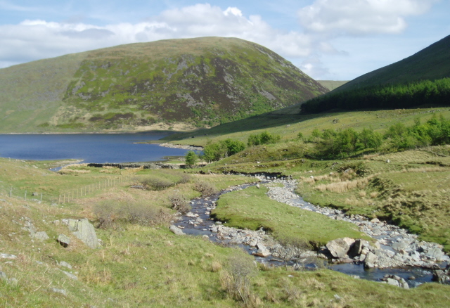
Megget Water

Megget Water is a river in the parish of Yarrow, Selkirkshire in the Scottish Borders area of Scotland. The Water rises at Broad Law (2,760 ft), passes...

St Mary's Loch

St Mary's Loch is the largest natural loch in the Scottish Borders, and is situated on the south side of the A708 road between Selkirk and Moffat, about...

Craigierig

Craigierig is a village on the Megget Reservoir, in the Scottish Borders area of Scotland, in the former Selkirkshire. Places nearby include the Glengaber...

Nearby Amenities

Located within 500m of 55.497099,-3.2148277
Power: pole
Lat/Long: 55.4971941/-3.2166845
Power: pole
Lat/Long: 55.4976471/-3.2166612
Power: pole
Lat/Long: 55.497931/-3.2166273
Power: pole
Lat/Long: 55.4982126/-3.2165977
Power: pole
Lat/Long: 55.4964429/-3.2081533
Power: pole
Lat/Long: 55.4965878/-3.2092385
Power: pole
Lat/Long: 55.4967388/-3.2103279
Power: pole
Lat/Long: 55.4968766/-3.2113581
Power: pole
Lat/Long: 55.4970048/-3.2122994
Power: pole
Lat/Long: 55.4971606/-3.2134819
Power: pole
Lat/Long: 55.4974925/-3.214457
Power: pole
Lat/Long: 55.4978915/-3.2156395
Power: pole
Lat/Long: 55.4985745/-3.2176596
Power: pole
Lat/Long: 55.4989315/-3.2187405
Power: pole
Lat/Long: 55.4990861/-3.2210484
The data included in this document is from www.openstreetmap.org. The data is made available under ODbL.

Have you been to Cappercleuch?

Leave your review of Cappercleuch below (or comments, questions and feedback).