Long Wood

Wood, Forest in Kirkcudbrightshire

Scotland

Long Wood

Water Wheelpit at Pibble Mine This wheelpit and associated roofless ruined building that stands alongside appear to part of the ore dressing works for Pibble Mine. 
Below the building is a large area of grassed over finely crushed material that forms a fan.
Water Wheelpit at Pibble Mine Credit: Matthew Hatton

Long Wood is a picturesque forest located in the historical county of Kirkcudbrightshire, in the southwest of Scotland. Covering an area of approximately 500 acres, this woodland is a haven for nature enthusiasts and those seeking tranquility amidst the beauty of the Scottish countryside.

The forest is predominantly composed of a mix of deciduous and coniferous trees, creating a diverse and vibrant ecosystem. Towering oak, beech, and birch trees dominate the landscape, providing a dense canopy that offers shade during the summer months. The undergrowth is adorned with an array of wildflowers, ferns, and mosses, adding to the enchanting ambiance of the woodland.

Long Wood is crisscrossed by a network of well-maintained walking trails, allowing visitors to explore its beauty at their own pace. These paths wind through the forest, offering glimpses of secluded glens, babbling brooks, and small ponds that are home to a variety of wildlife. It is not uncommon to spot red squirrels, roe deer, and a plethora of bird species, including woodpeckers and owls, as you wander through the woods.

The forest is also steeped in history, with remnants of ancient settlements and fortifications scattered throughout. Archaeological finds suggest that the area has been inhabited since Neolithic times, and remnants of Iron Age hillforts and Roman encampments have been discovered nearby.

Long Wood truly offers a captivating experience for nature lovers and history enthusiasts alike, providing a peaceful retreat in the heart of Kirkcudbrightshire's stunning landscape.

If you have any feedback on the listing, please let us know in the comments section below.

Long Wood Images

Images are sourced within 2km of 54.918924/-4.3100641 or Grid Reference NX5260. Thanks to Geograph Open Source API. All images are credited.

Water Wheelpit at Pibble Mine This wheelpit and associated roofless ruined building that stands alongside appear to part of the ore dressing works for Pibble Mine. 
Below the building is a large area of grassed over finely crushed material that forms a fan.
Water Wheelpit at Pibble Mine
This wheelpit and associated roofless ruined building that stands alongside appear to part of the ore dressing works for Pibble Mine. Below the building is a large area of grassed over finely crushed material that forms a fan.
Mine Shaft, Pibble Mine Rather a rubbish bit of fencing around this old mine shaft. I suppose the farm must be happy with it so long as his animals don't fall into it. In the background can be seen the Cornish Engine House, the main feature of Pibble Mine, and the spoil from the levels that penetrate the hillside. 
Having seen a YouTube video of the inside of this hill, I wouldn't recommend anyone attempting to explore it. The adits lead straight into stopes which plunge into the depths almost immediately.
Mine Shaft, Pibble Mine
Rather a rubbish bit of fencing around this old mine shaft. I suppose the farm must be happy with it so long as his animals don't fall into it. In the background can be seen the Cornish Engine House, the main feature of Pibble Mine, and the spoil from the levels that penetrate the hillside. Having seen a YouTube video of the inside of this hill, I wouldn't recommend anyone attempting to explore it. The adits lead straight into stopes which plunge into the depths almost immediately.
A Feat of Victorian Engineering The Cornish Engine House at Pibble Mine was built for a Cornish steam-pumping engine. The engine is reputed to have been made in 1852 by the St Austell foundry in Cornwall. The engine house originally measured 15 m high, 9 m in length and 6 m wide with walls c0.8m thick. It is constructed of Creetown granite quoins (corner stones). The 'bob' wall has collapsed into the pumping shaft. 
To the side can be seen remains of the boiler house, this also has the footings of its chimney still recognisable.
A Feat of Victorian Engineering
The Cornish Engine House at Pibble Mine was built for a Cornish steam-pumping engine. The engine is reputed to have been made in 1852 by the St Austell foundry in Cornwall. The engine house originally measured 15 m high, 9 m in length and 6 m wide with walls c0.8m thick. It is constructed of Creetown granite quoins (corner stones). The 'bob' wall has collapsed into the pumping shaft. To the side can be seen remains of the boiler house, this also has the footings of its chimney still recognisable.
Mark Burn near Money Knowe Small upland stream that begins its journey on Pibble Hill, and is probably full of heavy metals from the spoil heaps of the disused 19thC Pibble Mine.
Mark Burn near Money Knowe
Small upland stream that begins its journey on Pibble Hill, and is probably full of heavy metals from the spoil heaps of the disused 19thC Pibble Mine.
Upland pasture near Pibble Cottage Beyond is Long Wood, a plantation of conifers, which suffered from the gale force winds in the winter of 2021-22, but it has framed the Cornish Engine House at Pibble Mine quite nicely!
Upland pasture near Pibble Cottage
Beyond is Long Wood, a plantation of conifers, which suffered from the gale force winds in the winter of 2021-22, but it has framed the Cornish Engine House at Pibble Mine quite nicely!
Minor road leading to Creetown
Old Farm Machinery This piece of rusting farm machinery has been abandoned on the slope beneath Pibble Mine. I photographed it in October 2012, and it's still there four years later in September 2016!
Old Farm Machinery
This piece of rusting farm machinery has been abandoned on the slope beneath Pibble Mine. I photographed it in October 2012, and it's still there four years later in September 2016!
Pibble Mine Reservoir Pibble Mine is the site of the only Cornish pumping engine house on mainland Scotland. A reservoir was built a little to the west of the mine, and it is sometimes used by anglers. In 2012 there existed the remains of a wooden hut used by the anglers, but it had been blown down by the strong winds experienced there. Sometime in the intervening four years, it must have been replaced by another shelter, which has unfortunately been burnt down.
Pibble Mine Reservoir
Pibble Mine is the site of the only Cornish pumping engine house on mainland Scotland. A reservoir was built a little to the west of the mine, and it is sometimes used by anglers. In 2012 there existed the remains of a wooden hut used by the anglers, but it had been blown down by the strong winds experienced there. Sometime in the intervening four years, it must have been replaced by another shelter, which has unfortunately been burnt down.
Craig Bridge, north-east of Creetown Craig Bridge is a standard rural bridge carrying the minor road from Creetown to Gatehouse of Fleet across the Moneypool Burn, a tributary of the River Cree.
Craig Bridge, north-east of Creetown
Craig Bridge is a standard rural bridge carrying the minor road from Creetown to Gatehouse of Fleet across the Moneypool Burn, a tributary of the River Cree.
Dumfries-Portpatrick railway, track-bed near Gatehouse station This railway line, on a small embankment here, closed in 1965.
Dumfries-Portpatrick railway, track-bed near Gatehouse station
This railway line, on a small embankment here, closed in 1965.
Culcronchie Burn Upstream of Culcronchie Bridge.
Culcronchie Burn
Upstream of Culcronchie Bridge.
Field, Craig With Cairnsmore of Fleet in the background.
Field, Craig
With Cairnsmore of Fleet in the background.
Moneypool Burn
Moneypool Burn
Portpatrick Railway As is often the case with railway trackbeds, the cutting is flooded.
Portpatrick Railway
As is often the case with railway trackbeds, the cutting is flooded.
Wood-lined minor road beside Moneypool Burn Looking south-westward.
Wood-lined minor road beside Moneypool Burn
Looking south-westward.
Minor road and Culcronchie Bridge crossing Culcronchie Burn Looking eastward.
Minor road and Culcronchie Bridge crossing Culcronchie Burn
Looking eastward.
Minor road crossing Craig Bridge Looking north-eastward.
Minor road crossing Craig Bridge
Looking north-eastward.
Minor road between New Rusko and Craig Bridge Looking south-westward.
Minor road between New Rusko and Craig Bridge
Looking south-westward.
Show me another place!

Long Wood is located at Grid Ref: NX5260 (Lat: 54.918924, Lng: -4.3100641)

Unitary Authority: Dumfries and Galloway

Police Authority: Dumfries and Galloway

What 3 Words

///cards.helpfully.envisage. Near Newton Stewart, Dumfries & Galloway

Nearby Locations

Long Wood

Related Wikis

Glenquicken stone circle

Glenquicken stone circle or Billy Diamond's Bridge stone circle (grid reference NX50965821) is an oval stone circle with a central pillar, two miles east...

Gatehouse of Fleet railway station

Gatehouse of Fleet railway station served the town of Gatehouse of Fleet, Dumfries and Galloway, Scotland from 1861 to 1965 on the Portpatrick and Wigtownshire...

Creetown railway station

Creetown railway station served the town of Creetown, Dumfries and Galloway, Scotland from 1861 to 1965 on the Portpatrick and Wigtownshire Joint Railway...

Kirkmabreck

Kirkmabreck is a civil parish in the historic county of Kirkcudbrightshire in the Dumfries and Galloway council area, Scotland. Situated in the historic...

Creetown

Creetown (/ˈkri:tən/, sometimes /'kri:taʊn/) is a small seaside town in the Stewartry of Kirkcudbright, in Galloway in the Dumfries and Galloway council...

Creetown F.C.

Creetown Football Club are a football club based in Creetown in the Dumfries and Galloway area of Scotland. Formed in 1905 as Creetown Rifle Volunteers...
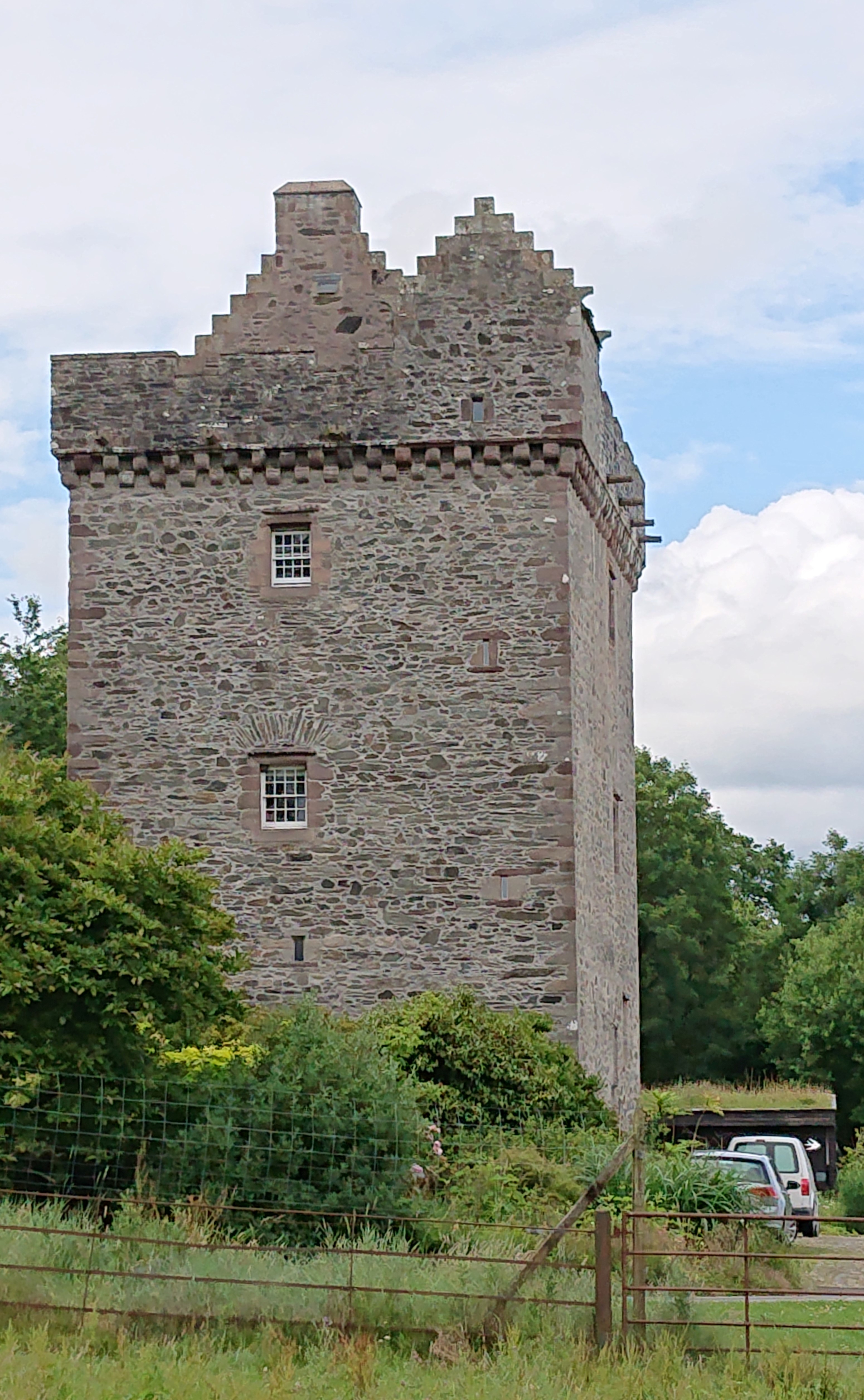
Rusco Tower

Rusco Tower, sometimes called Rusco Castle, is a tower house near Gatehouse of Fleet in Dumfries and Galloway, Scotland. Built around 1500 for Mariota...
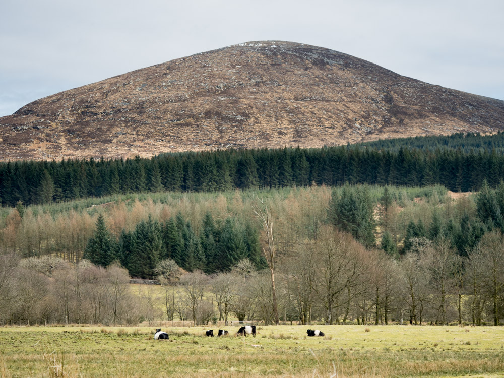
Cairnsmore of Fleet

Cairnsmore of Fleet is an isolated mountain in the Southern Uplands of Scotland. The mountain forms an unafforested granite massif, whose highest point...

Nearby Amenities

Located within 500m of 54.918924,-4.3100641
Power: pole
Lat/Long: 54.9166116/-4.3157013
Power: pole
Lat/Long: 54.9168107/-4.3167213
The data included in this document is from www.openstreetmap.org. The data is made available under ODbL.

Have you been to Long Wood?

Leave your review of Long Wood below (or comments, questions and feedback).