Capel-y-ffin

Settlement in Brecknockshire

Wales

Capel-y-ffin

Forest fence Looking uphill in deteriorating conditions alongside the northern boundary of the Mynydd Du Forest.
Forest fence Credit: Jonathan Billinger

Capel-y-ffin is a small hamlet located in the county of Brecknockshire, Wales. Nestled in the scenic Black Mountains, it sits at an elevation of about 380 meters above sea level. The name Capel-y-ffin translates to "chapel of the boundary" in Welsh, hinting at its historical significance as a place of worship.

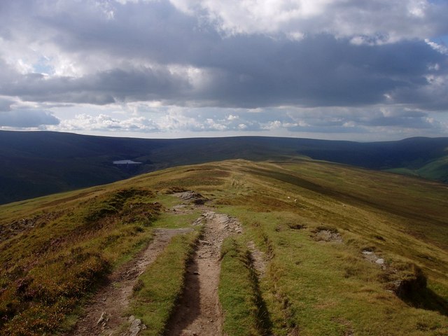
The village is known for its tranquil and picturesque surroundings, attracting nature enthusiasts and hikers looking to explore the nearby Brecon Beacons National Park. The landscape boasts breathtaking views of rolling hills, deep valleys, and cascading waterfalls, making it a popular destination for outdoor activities such as hiking, cycling, and birdwatching.

Although small in size, Capel-y-ffin has a rich cultural heritage. The village is home to a small chapel, which was built in 1762 and is still an active place of worship today. The chapel's simple yet elegant design adds to the charm of the village.

Capel-y-ffin has a close-knit community, with a handful of residential properties and a few local businesses. There are no shops or amenities within the village itself, but nearby towns like Hay-on-Wye and Crickhowell offer a range of facilities and services for residents and visitors.

In summary, Capel-y-ffin is a remote and idyllic hamlet situated in the stunning Black Mountains of Brecknockshire. Its natural beauty, cultural heritage, and peaceful atmosphere make it a cherished destination for those seeking solace in nature.

If you have any feedback on the listing, please let us know in the comments section below.

Capel-y-ffin Images

Images are sourced within 2km of 51.976084/-3.088242 or Grid Reference SO2531. Thanks to Geograph Open Source API. All images are credited.

Forest fence Looking uphill in deteriorating conditions alongside the northern boundary of the Mynydd Du Forest.
Forest fence
Looking uphill in deteriorating conditions alongside the northern boundary of the Mynydd Du Forest.
Chwarel y Fan According to the discussion ( <a title="https://www.geograph.org.uk/discuss/index.php?&action=vthread&forum=6&topic=1163" href="https://www.geograph.org.uk/discuss/index.php?&action=vthread&forum=6&topic=1163">Link</a> ) Chwarel Y Fan is the highest point in old Gwent. This photo is taken looking east from the other side of the Grwyne Fawr valley, near Pen y Gadair Fawr - which is far higher, but across the border.
Chwarel y Fan
According to the discussion ( Link ) Chwarel Y Fan is the highest point in old Gwent. This photo is taken looking east from the other side of the Grwyne Fawr valley, near Pen y Gadair Fawr - which is far higher, but across the border.
Track along the central Black Mountains ridge North of Chwarel y Fan.  The lake in the distance is Grwyne Fawr reservoir (<a href="https://www.geograph.org.uk/photo/135959">SO2330 : Grwyne Fawr Reservoir dam</a>).
Track along the central Black Mountains ridge
North of Chwarel y Fan. The lake in the distance is Grwyne Fawr reservoir (SO2330 : Grwyne Fawr Reservoir dam).
Approaching the summit of Chwarel y Fan The summit cairn looms up out of the mist.  This is the highest point of the ridge.  It has extensive covering of stones and the remains of a quarry.  Fancy working up here?
Approaching the summit of Chwarel y Fan
The summit cairn looms up out of the mist. This is the highest point of the ridge. It has extensive covering of stones and the remains of a quarry. Fancy working up here?
Evidence of forestry The western slopes of Chwarel y Fan are relatively gentle.  There are the remains of a planted woodland quite close to the summit.
Evidence of forestry
The western slopes of Chwarel y Fan are relatively gentle. There are the remains of a planted woodland quite close to the summit.
North of Chwarel y Fan The ridge is much broader here, with gentle slopes either side.  There is no protection when the rain starts in earnest though.
North of Chwarel y Fan
The ridge is much broader here, with gentle slopes either side. There is no protection when the rain starts in earnest though.
Towards Vale of Ewyas It's down there somewhere.  This group of walkers sensibly heads downhill with the rain at their back.
Towards Vale of Ewyas
It's down there somewhere. This group of walkers sensibly heads downhill with the rain at their back.
Out in the snow
Out in the snow
Rock on Chwarel y Fan There is little bare exposed rock on the Black Mountains, these rocks are to the north of Chwarel y Fan.  At 679m this is the highest point in the county of Monmouthshire.
Rock on Chwarel y Fan
There is little bare exposed rock on the Black Mountains, these rocks are to the north of Chwarel y Fan. At 679m this is the highest point in the county of Monmouthshire.
Path on Chwarel y Fan Path approaching Chwarel y Fan, at 679m the highest point in Monmouthshire, from the north.
Path on Chwarel y Fan
Path approaching Chwarel y Fan, at 679m the highest point in Monmouthshire, from the north.
View to Waun Fach View to Waun Fach, the highest point in the Black Mountains from Chwarel y Fan. Waun Fach (811m) is the broad summit plateau on the right, Pen y Gadair Fawr (800m) is the small summit on the left
View to Waun Fach
View to Waun Fach, the highest point in the Black Mountains from Chwarel y Fan. Waun Fach (811m) is the broad summit plateau on the right, Pen y Gadair Fawr (800m) is the small summit on the left
Track in Cwm Grwyne Track climbing Cwm Grwyne with Grwyne Fawr following below.  The dam of Grwyne Fawr Reservoir can eb seen at the head of the valley.
Track in Cwm Grwyne
Track climbing Cwm Grwyne with Grwyne Fawr following below. The dam of Grwyne Fawr Reservoir can eb seen at the head of the valley.
Path approaching Chwarel y Fan Path approaching Chwarel y Fan, at 679m the highest point in Monmouthshire.  To the right in the distance is Sugar Loaf.
Path approaching Chwarel y Fan
Path approaching Chwarel y Fan, at 679m the highest point in Monmouthshire. To the right in the distance is Sugar Loaf.
Chwarel y Fan Approaching the summit of Chwarel y Fan, the highest point in Monmouthshire, from the north.  A figure can be seen on the summit.  The Vale of Ewyas is below on the left.
Chwarel y Fan
Approaching the summit of Chwarel y Fan, the highest point in Monmouthshire, from the north. A figure can be seen on the summit. The Vale of Ewyas is below on the left.
Path near Chwarel y fan in winter It's that sort of cold that is beyond bracing and into challenging.
Path near Chwarel y fan in winter
It's that sort of cold that is beyond bracing and into challenging.
Track to Grwyne Fawr reservoir
Footpath heading towards the Mynydd Du Forest
Ridge rising towards Chwarel y Fan The ridge connecting  Rhos Dirion and Chwarel y Fan is mainly broad and wet but approaching that last peak it narrows, steepens and becomes dry.
Ridge rising towards Chwarel y Fan
The ridge connecting Rhos Dirion and Chwarel y Fan is mainly broad and wet but approaching that last peak it narrows, steepens and becomes dry.
Show me another place!

Capel-y-ffin is located at Grid Ref: SO2531 (Lat: 51.976084, Lng: -3.088242)

Unitary Authority: Powys

Police Authority: Dyfed Powys

What 3 Words

///surveyors.showed.palaces. Near Llanveynoe, Herefordshire

Nearby Locations

Capel-y-ffin

Related Wikis

Capel-y-ffin

Capel-y-ffin (Welsh for 'chapel of the boundary') is a hamlet near the English-Welsh border, a couple of miles north of Llanthony in Powys, Wales. It lies...

Llanthony Abbey

Llanthony Abbey is a former Anglican monastic institution founded in 1869 by Joseph Leycester Lyne (Father Ignatius), in the Welsh village of Capel-y-ffin...

Hatterrall Ridge

The Hatterrall Ridge (sometimes spelled Hatterall) is a ridge in the Black Mountains forming the border between Powys and Monmouthshire in Wales and Herefordshire...

Chwarel y Fan

Chwarel y Fan is a peak in the Black Mountains in south-eastern Wales. It is the highest rise on the long ridge which extends southeastwards from Rhos...

Nearby Amenities

Located within 500m of 51.976084,-3.088242
Telephone
Booth: K6
Covered: booth
Listed Status: Grade II
Operator: BT
Phone: +441873 890189
Lat/Long: 51.977011/-3.0865621
Capel-y-ffin
Is In: Gwent
Place: hamlet
Wikidata: Q990117
Lat/Long: 51.97764/-3.0865111
Grange Pony Trekking
Leisure: horse_riding
Tourism: camp_site
Website: https://www.grangetrekking-wales.co.uk
Lat/Long: 51.9766631/-3.0929766
Post Box
Post Box Type: wall
Ref: NP7 41
Royal Cypher: EIIR
Royal Cypher Wikidata: Q33102113
Lat/Long: 51.9769721/-3.0863195
Grange Trekking Centre
Addr City: Capel-y-Ffin
Addr Postcode: NP7 7NP
Contact Phone: 01873890215
Tourism: attraction
Website: https://www.grangetrekking-wales.co.uk/
Lat/Long: 51.976424/-3.0930019
Barrier: stile
Lat/Long: 51.9797901/-3.0909964
Barrier: stile
Lat/Long: 51.9786905/-3.0879759
Ford: yes
Source: survey
Lat/Long: 51.9740462/-3.0937968
Barrier: stile
Foot: yes
Material: wood
Stile: stepover
Lat/Long: 51.9757476/-3.0898552
Direction: ESE
Generator Method: photovoltaic
Generator Output Electricity: yes
Generator Solar Modules: 10
Generator Source: solar
Generator Type: solar_photovoltaic_panel
Location: roof
Power: generator
Lat/Long: 51.9773915/-3.0842185
'Our Lady of Llanthony'
Artwork Type: statue
Tourism: artwork
Lat/Long: 51.9761674/-3.0910774
Historic: wayside_cross
Lat/Long: 51.9767697/-3.0920186
Father Ignatius
Historic: memorial
Memorial: plaque
Lat/Long: 51.9760987/-3.0904707
The data included in this document is from www.openstreetmap.org. The data is made available under ODbL.

Have you been to Capel-y-ffin?

Leave your review of Capel-y-ffin below (or comments, questions and feedback).