Capel St Mary

Settlement in Suffolk Babergh

England

Capel St Mary

Esso Service Station on A12 north near Capel St Mary
Esso Service Station on A12 north near Capel St Mary Credit: Roy Hughes

Capel St Mary is a picturesque village located in the county of Suffolk, England. Situated just south of Ipswich, the village is surrounded by beautiful countryside and boasts a population of approximately 3,500 residents.

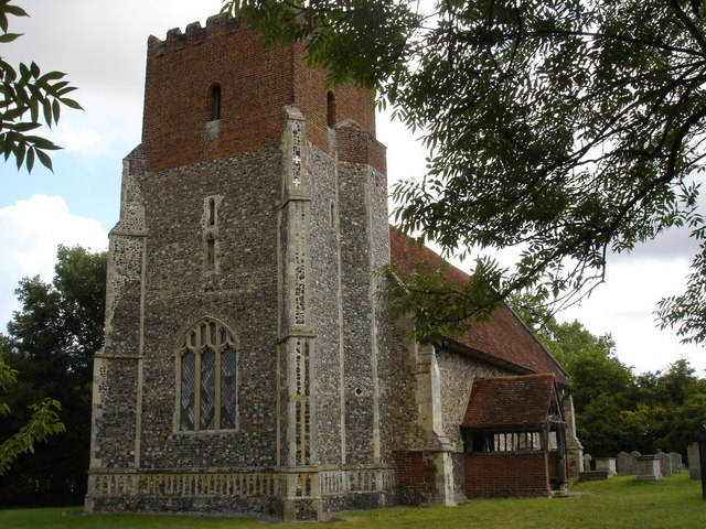
The village is known for its charming, traditional English feel with many historic buildings and thatched cottages lining its streets. It is centered around a village green, where locals gather for community events and activities. The green is also home to a stunning medieval church, St Mary's, which dates back to the 14th century and is a prominent feature of the village skyline.

Capel St Mary offers a range of amenities to its residents, including a primary school, a post office, a convenience store, and several pubs and restaurants. The village also has a strong sense of community, with various clubs and organizations catering to different interests, such as sports, arts, and heritage.

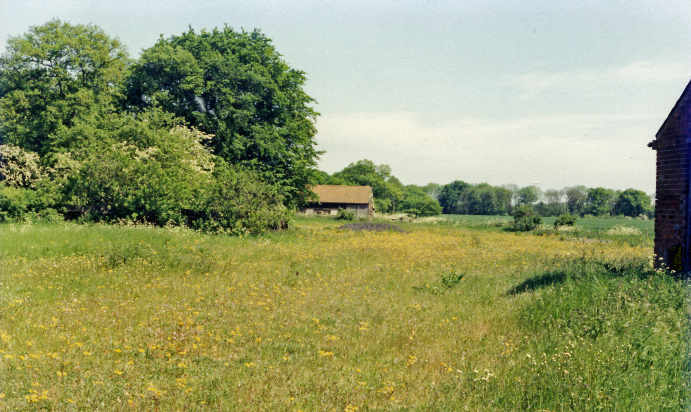
Surrounded by rolling countryside, Capel St Mary is a haven for nature lovers and outdoor enthusiasts. The nearby Dedham Vale Area of Outstanding Natural Beauty offers scenic walking trails and opportunities for wildlife spotting. The village is also conveniently located for access to the Suffolk coast, with popular seaside towns such as Felixstowe just a short drive away.

Overall, Capel St Mary is a quintessentially English village, offering a peaceful and idyllic lifestyle for its residents while providing easy access to both rural and coastal attractions.

If you have any feedback on the listing, please let us know in the comments section below.

Capel St Mary Images

Images are sourced within 2km of 52.003017/1.0475051 or Grid Reference TM0938. Thanks to Geograph Open Source API. All images are credited.

Esso Service Station on A12 north near Capel St Mary
Jet garage on A12 north at Capel St Mary
The A12, Capel St Mary I've been here before. <a title="https://www.geograph.org.uk/photo/5377066" href="https://www.geograph.org.uk/photo/5377066">Link</a>
The A12, Capel St Mary
I've been here before. Link
The A12, Capel St Mary
St. Mary's church, Capel St. Mary, Suffolk This is a mainly 15th century church.  At one time it had a spire. Inside, there is a fine hammerbeam roof.
St. Mary's church, Capel St. Mary, Suffolk
This is a mainly 15th century church. At one time it had a spire. Inside, there is a fine hammerbeam roof.
'The White Horse' inn, Capel St. Mary, Suffolk The main road in this picture, was once the A.12 and this inn must have been a very popular place back then. Parts of the inn date back to the early 18th century, perhaps even earlier.
'The White Horse' inn, Capel St. Mary, Suffolk
The main road in this picture, was once the A.12 and this inn must have been a very popular place back then. Parts of the inn date back to the early 18th century, perhaps even earlier.
All Saints church, Little Wenham, Suffolk This church, seen across a field, dates from 1300 and stands close to the 13th century Little Wenham Hall, which is private. The brick built upper stage of the tower is Tudor.
All Saints church, Little Wenham, Suffolk
This church, seen across a field, dates from 1300 and stands close to the 13th century Little Wenham Hall, which is private. The brick built upper stage of the tower is Tudor.
By Pass Nurseries, Capel St Mary, Suffolk
Little Chef at Capel St Mary, Suffolk This is by a major junction on the A.12
Little Chef at Capel St Mary, Suffolk
This is by a major junction on the A.12
Bentley Road, Bentley, Suffolk This is the view driving away from Bentley towards Capel St Mary.
Bentley Road, Bentley, Suffolk
This is the view driving away from Bentley towards Capel St Mary.
White House, near Copdock, Suffolk This 19th century house stands alongside the original A.12, which follows the course of a Roman road.
White House, near Copdock, Suffolk
This 19th century house stands alongside the original A.12, which follows the course of a Roman road.
Allotments along Pound Lane
Capel St. Mary, Suffolk This is the view at the end of Pound Lane by St. Mary's church.
Capel St. Mary, Suffolk
This is the view at the end of Pound Lane by St. Mary's church.
Clay Hall (behind a ripe crop of oil seed rape) The footpath passes close to Clay Hall and through the farmyard which has a pond with ducks
Clay Hall (behind a ripe crop of oil seed rape)
The footpath passes close to Clay Hall and through the farmyard which has a pond with ducks
Stile entering wood, track of disused railway The stile is interesting because it is made of bent metal girders. Could they be a relic of the disused railway (line that used to connect Hadleigh with the Norwich-London line). In the linear wood beyond, the line of the old railway is easy to envisage.
Stile entering wood, track of disused railway
The stile is interesting because it is made of bent metal girders. Could they be a relic of the disused railway (line that used to connect Hadleigh with the Norwich-London line). In the linear wood beyond, the line of the old railway is easy to envisage.
Footpath in Binny's Wood through hosts of horsetails This wood (or at least its lower boggy parts) is crammed full of Equisetum arvense (horsetail, bottle brush, snake grass, Lego weed - take your pick!) An ancient primitive plant, it is segmented so that sections pull apart like Lego!
Footpath in Binny's Wood through hosts of horsetails
This wood (or at least its lower boggy parts) is crammed full of Equisetum arvense (horsetail, bottle brush, snake grass, Lego weed - take your pick!) An ancient primitive plant, it is segmented so that sections pull apart like Lego!
Hill Farm across stubble field Not shown on the Landranger, this farm is up the slope from Chaplain's Farm.  As usual, the Explorer series shows a fuller picture
Hill Farm across stubble field
Not shown on the Landranger, this farm is up the slope from Chaplain's Farm. As usual, the Explorer series shows a fuller picture
Little Wenham Castle The castle is apparently within an enclosed private area, moated and fenced.  In fact, that seems to be the case for virtually the whole of this village, which is only accessible by bridleway and footpath
Little Wenham Castle
The castle is apparently within an enclosed private area, moated and fenced. In fact, that seems to be the case for virtually the whole of this village, which is only accessible by bridleway and footpath
Show me another place!

Capel St Mary is located at Grid Ref: TM0938 (Lat: 52.003017, Lng: 1.0475051)

Administrative County: Suffolk

District: Babergh

Police Authority: Suffolk

What 3 Words

///expose.looms.menswear. Near Capel St Mary, Suffolk

Nearby Locations

Capel St Mary

Related Wikis

Capel St. Mary

Capel St. Mary – commonly known as Capel – is a village in Suffolk, England. It is about 6 miles (10 km) south-west of Ipswich and 2 miles (3 km) from...

Capel railway station

Capel railway station was a station in Capel St Mary, Suffolk, on a short branch line from Bentley Junction to Hadleigh. The station buildings were remarkably...

Little Wenham

Little Wenham is a small village in Suffolk, England. It is part of the civil parish of Wenham Parva – the ancient name for Little Wenham) within Babergh...

All Saints Church, Little Wenham

All Saints Church is a redundant Anglican church in the village of Little Wenham, Suffolk, England. It is recorded in the National Heritage List for England...

Nearby Amenities

Located within 500m of 52.003017,1.0475051
Crossing
Crossing Island: no
Crossing Markings: no
Crossing Signals: no
Tactile Paving: no
Lat/Long: 52.0021627/1.0499205
Capel St Mary
Place: village
Wikidata: Q2148436
Lat/Long: 52.0036918/1.049505
Kerb: raised
Lat/Long: 52.0050023/1.0524893
Bus Stop
Methodist Church
Bench: yes
Local Ref: o/s
Naptan AtcoCode: 390010553
Naptan Bearing: E
Naptan CommonName: Methodist Church
Naptan Landmark: Methodist Church
Naptan NaptanCode: sufagpdw
Naptan Street: The Street
Naptan Verified: no
Public Transport: platform
Shelter: yes
Source: naptan_import
Tactile Paving: no
Lat/Long: 52.0033553/1.049375
Bus Stop
Methodist Church
Bench: no
Local Ref: opp
Naptan AtcoCode: 390010554
Naptan Bearing: W
Naptan CommonName: Methodist Church
Naptan Landmark: Methodist Church
Naptan NaptanCode: sufagpga
Naptan Street: The Street
Naptan Verified: no
Public Transport: platform
Shelter: no
Source: naptan_import
Tactile Paving: no
Lat/Long: 52.0032312/1.0493082
Bus Stop
Telephone Exchange
Bench: no
Bin: yes
Bus: yes
Lit: yes
Naptan AtcoCode: 390010555
Naptan NaptanCode: sufagpgd
Naptan Verified: no
Public Transport: platform
Shelter: no
Source: naptan_import
Tactile Paving: no
Lat/Long: 52.0039955/1.0426051
Bus Stop
Telephone Exchange
Bench: no
Bin: yes
Lit: yes
Naptan AtcoCode: 390010556
Naptan NaptanCode: sufagpgj
Naptan Verified: no
Public Transport: platform
Shelter: no
Source: naptan_import
Tactile Paving: no
Lat/Long: 52.0038057/1.0427459
Bus Stop
The Street
Local Ref: adj
Naptan AtcoCode: 390010557
Naptan Bearing: N
Naptan CommonName: The Street
Naptan Landmark: The Street
Naptan NaptanCode: sufagpgm
Naptan Street: Thorney Road
Naptan Verified: no
Public Transport: platform
Source: naptan_import
Lat/Long: 52.0048532/1.0412213
Bus Stop
The Street
Local Ref: opp
Naptan AtcoCode: 390010558
Naptan Bearing: S
Naptan BusStopType: CUS
Naptan CommonName: The Street
Naptan Landmark: The Street
Naptan NaptanCode: sufagpgp
Naptan Street: Thorney Road
Naptan Verified: no
Public Transport: platform
Source: naptan_import
Lat/Long: 52.0050371/1.0413867
Bus Stop
Ash Grove
Bench: no
Local Ref: opp
Naptan AtcoCode: 390010559
Naptan Bearing: E
Naptan CommonName: Ash Grove
Naptan Landmark: Ash Grove
Naptan NaptanCode: sufagpgt
Naptan Street: Thorney Road
Naptan Verified: no
Public Transport: platform
Shelter: no
Source: naptan_import
Tactile Paving: no
Lat/Long: 52.0059615/1.043548
Ash Grove
Local Ref: adj
Naptan AtcoCode: 390010560
Naptan Bearing: W
Naptan BusStopType: CUS
Naptan CommonName: Ash Grove
Naptan Landmark: Ash Grove
Naptan NaptanCode: sufagpgw
Naptan Street: Thorney Road
Naptan Verified: no
Public Transport: platform
Source: naptan_import
Lat/Long: 52.0058961/1.0436456
Bus Stop
Peters Grove
Bench: no
Bin: no
Lit: yes
Local Ref: adj
Naptan AtcoCode: 390010561
Naptan Bearing: E
Naptan CommonName: Peters Grove
Naptan Landmark: Peters Grove
Naptan NaptanCode: sufagpja
Naptan Street: Thorney Road
Naptan Verified: no
Public Transport: platform
Shelter: no
Source: naptan_import
Tactile Paving: no
Lat/Long: 52.0052909/1.0489811
Peters Grove
Bench: yes
Bin: yes
Lit: yes
Local Ref: opp
Naptan AtcoCode: 390010562
Naptan Bearing: W
Naptan BusStopType: CUS
Naptan CommonName: Peters Grove
Naptan Landmark: Peters Grove
Naptan NaptanCode: sufagpjd
Naptan Street: Thorney Road
Naptan Verified: no
Public Transport: platform
Shelter: no
Source: naptan_import
Tactile Paving: no
Lat/Long: 52.0052389/1.0492262
Bus Stop
Garrods
Bench: no
Bin: no
Lit: yes
Local Ref: opp
Naptan AtcoCode: 390010563
Naptan Bearing: E
Naptan CommonName: Garrods
Naptan Landmark: Garrods
Naptan NaptanCode: sufagpjg
Naptan Street: Thorney Road
Naptan Verified: no
Public Transport: platform
Shelter: no
Source: naptan_import
Tactile Paving: no
Lat/Long: 52.0049966/1.0527896
Garrods
Bench: no
Bin: no
Lit: yes
Local Ref: adj
Naptan AtcoCode: 390010564
Naptan Bearing: W
Naptan BusStopType: CUS
Naptan CommonName: Garrods
Naptan Landmark: Garrods
Naptan NaptanCode: sufagpjm
Naptan Street: Thorney Road
Naptan Verified: no
Public Transport: platform
Shelter: no
Source: naptan_import
Tactile Paving: no
Lat/Long: 52.0049431/1.0527714
Friars
Local Ref: adj
Naptan AtcoCode: 390010673
Naptan Bearing: NE
Naptan BusStopType: CUS
Naptan CommonName: Friars
Naptan Landmark: Garden Centre
Naptan NaptanCode: sufjdjmt
Naptan Street: London Road
Naptan Verified: no
Public Transport: platform
Source: naptan_import
Lat/Long: 51.9999149/1.0523321
Library
Capel St Mary Library
Addr City: Ipswich
Addr Housename: Village Hall
Addr Postcode: IP9 2EP
Addr Street: The Street
Addr Village: Capel St Mary
Operator: Suffolk County Council
Url: https://www.suffolklibraries.co.uk/visit/locations-and-times/capel-st-mary-library
Wikidata: Q55113015
Lat/Long: 52.0037935/1.0492203
Place Of Worship
Capel St Mary Methodist Church
Check Date: 2024-04-05
Denomination: methodist
Religion: christian
Lat/Long: 52.0033841/1.0489804
Material: wood
Power: pole
Lat/Long: 52.007304/1.04729
Material: wood
Power: pole
Lat/Long: 52.0070497/1.0457987
Power: pole
Lat/Long: 52.0071206/1.0446212
Traffic Calming: table
Lat/Long: 52.0005633/1.052143
Crossing
Crossing: zebra
Crossing Island: no
Kerb: flush
Tactile Paving: yes
Lat/Long: 52.0031497/1.0442116
Kerb: raised
Lat/Long: 52.0043914/1.0481641
Capel Bakery
Addr City: Ipswich
Addr Housenumber: 44
Addr Postcode: IP9 2EP
Addr Street: The Street
Addr Village: Capel St Mary
Fhrs Id: 526665
Fixme: Check name (FHRS has "Bakers Delight")
Opening Hours: Mo,Sa 06:00-14:00; Tu-Fr 06:00-15:00
Phone: +44 1473311494
Shop: bakery
Source Addr: FSA Food Hygiene Ratings Database
Lat/Long: 52.0038017/1.0496489
Dentist
Capel Dental
Lat/Long: 52.0040074/1.0540765
Restaurant
Mother Indian
Addr City: Ipswich
Addr Housenumber: 40
Addr Postcode: IP9 2EP
Addr Street: The Street
Addr Village: Capel St Mary
Fhrs Id: 815475
Source Addr: FSA Food Hygiene Ratings Database
Lat/Long: 52.0038114/1.0498245
Hair Ministry Group
Addr City: Ipswich
Addr Housenumber: 42
Addr Postcode: IP9 2EP
Addr Street: The Street
Addr Village: Capel St Mary
Phone: +44 1473310273
Shop: hairdresser
Source Addr: interpolation
Unisex: yes
Lat/Long: 52.0038067/1.0497414
Post Box
Check Date Collection Times: 2022-12-22
Collection Times: Mo-Fr 16:45; Sa 10:00
Operator: Royal Mail
Operator Type: private
Operator Wikidata: Q638098
Post Box Design: type_a
Post Box Type: pillar
Ref: IP9 1206
Royal Cypher: EIIR
Royal Cypher Wikidata: Q33102113
Lat/Long: 52.0035619/1.0499606
Atm
Cash In: no
Check Date: 2024-04-05
Fee: no
Operator: Co-op
Lat/Long: 52.0037347/1.0500465
Fast Food
Magnificent Wok
Addr City: Ipswich
Addr Housenumber: 44a
Addr Postcode: IP9 2EP
Addr Street: The Street
Addr Village: Capel St Mary
Cuisine: chinese
Fhrs Id: 526979
Opening Hours: Mo-Sa 16:00-23:00; Su 16:00-22:00
Phone: +44 1473312233
Source Addr: FSA Food Hygiene Ratings Database
Takeaway: only
Lat/Long: 52.0037981/1.0495706
Post Box
Brand: Royal Mail
Brand Wikidata: Q638098
Collection Times: Mo-Fr 16:30; Sa 09:45
Operator: Royal Mail
Operator Type: private
Operator Wikidata: Q638098
Post Box Design: type_b
Post Box Type: pillar
Ref: IP9 1401
Royal Cypher: EIIR
Royal Cypher Wikidata: Q33102113
Lat/Long: 52.0040142/1.0425603
Waste Basket
Lat/Long: 52.0037465/1.0499704
Waste Basket
Lat/Long: 52.0037208/1.0496168
Waste Basket
Lat/Long: 52.0036605/1.0495916
Bench
Backrest: yes
Seats: 3
Lat/Long: 52.0035962/1.0496032
Bicycle Parking
Bicycle Parking: stands
Capacity: 14
Check Date Capacity: 2020-11-22
Covered: yes
Supervised: no
Lat/Long: 52.0037952/1.0499595
Post Office
Capel St Mary Post Office
Addr City: Ipswich
Addr Housename: Coop
Addr Housenumber: 38
Addr Postcode: IP9 2EP
Addr Street: The Street
Addr Village: Capel St Mary
Brand: Post Office
Brand Wikidata: Q1783168
Contact Website: https://www.postoffice.co.uk/branch-finder/3051307/capel
Opening Hours: Mo-Sa 07:00-22:00; Su 10:00-16:00
Ref Pol Id: 131256
Source Addr: pol_branch_list_2018-02
Lat/Long: 52.0036805/1.0502378
Bank
Suffolk Building Society
Brand Wikidata: Q6065542
Note: An agency branch run by Drayton Insurance Services
Opening Hours: Mo-Fr 09:00-17:00; Sa 09:00-12:00
Website: https://www.suffolkbuildingsociety.co.uk/agencies/capel-st-mary/
Lat/Long: 52.0033102/1.0508731
Historic: memorial
Memorial: war_memorial
Lat/Long: 52.0032357/1.0497037
Defibrillator
Defibrillator Location: On exterior wall of Coop, facing the car park on The Street, just to the right of the Main entrance.
Emergency: defibrillator
Indoor: no
Ref GB The Circuit: 0795E882-D0F7-4088-995F-AE9700B84FE3
Lat/Long: 52.0036709/1.0500541
Pharmacy
Capel Pharma
Lat/Long: 52.0036734/1.0504493
Recycling
Check Date Recycling: 2024-04-05
Recycling Glass Bottles: yes
Recycling Type: container
Lat/Long: 52.0035748/1.048842
Bench
Lat/Long: 52.0032276/1.0496617
Bench
Lat/Long: 52.0032413/1.0497489
Bench
Lat/Long: 52.0032425/1.0498428
Bar
Village Bar
Lat/Long: 52.0037782/1.0489909
Crossing
Crossing: unmarked
Crossing Markings: no
Lat/Long: 52.0032639/1.0547473
The data included in this document is from www.openstreetmap.org. The data is made available under ODbL.

Have you been to Capel St Mary?

Leave your review of Capel St Mary below (or comments, questions and feedback).