Black's Plantation

Wood, Forest in Wigtownshire

Scotland

Black's Plantation

Small Tortoiseshell Butterflies Four Small Tortoiseshell butterflies (Aglais urticae) feeding on Buddleia flowers.
Small Tortoiseshell Butterflies Credit: Jon Alexander

Black's Plantation is a sprawling woodland located in Wigtownshire, Scotland. Situated in the southern region of the country, this enchanting forest covers an area of approximately 500 acres. The woodland is named after the Black family who have owned and managed the plantation for several generations.

The landscape of Black's Plantation is a mesmerizing blend of ancient trees, dense undergrowth, and meandering pathways. The woodland is primarily made up of native tree species, including oak, beech, and rowan, which provide a diverse and vibrant habitat for various flora and fauna.

Visitors to Black's Plantation can indulge in a plethora of outdoor activities. The well-maintained network of walking trails offers the perfect opportunity for hikers and nature enthusiasts to explore the breathtaking beauty of the woodland. The plantation also provides a haven for birdwatchers, with a wide range of avian species, such as red kites and buzzards, making their homes within its boundaries.

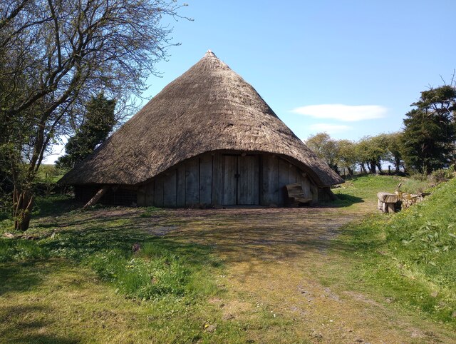
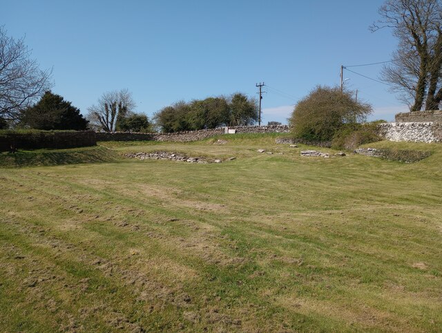
In addition to its natural charm, Black's Plantation boasts a rich historical significance. The forest contains the remains of an Iron Age fort, which stands as a testament to the area's ancient heritage. The Black family has taken great care to preserve the historical integrity of the woodland, allowing visitors to delve into its past while enjoying the tranquility of the present.

Overall, Black's Plantation is a captivating destination for those seeking solace in nature or an opportunity to immerse themselves in Scotland's rich history. Whether wandering through its winding trails or marveling at its ancient fort, visitors are sure to be enchanted by the beauty and serenity of this remarkable woodland.

If you have any feedback on the listing, please let us know in the comments section below.

Black's Plantation Images

Images are sourced within 2km of 54.734993/-4.4394693 or Grid Reference NX4340. Thanks to Geograph Open Source API. All images are credited.

Small Tortoiseshell Butterflies Four Small Tortoiseshell butterflies (Aglais urticae) feeding on Buddleia flowers.
Small Tortoiseshell Butterflies
Four Small Tortoiseshell butterflies (Aglais urticae) feeding on Buddleia flowers.
Painted Lady Butterfly The underside of a Painted Lady butterfly (Vanessa cardui) feeding on the flowers of a Buddleia.
Painted Lady Butterfly
The underside of a Painted Lady butterfly (Vanessa cardui) feeding on the flowers of a Buddleia.
Painted Lady Butterfly A rather faded Painted Lady butterfly (Vanessa cardui) on Buddleia flower spikes.
Painted Lady Butterfly
A rather faded Painted Lady butterfly (Vanessa cardui) on Buddleia flower spikes.
Peacock Butterfly A Peacock butterfly (Aglais io) on a Buddleia flower spike.
Peacock Butterfly
A Peacock butterfly (Aglais io) on a Buddleia flower spike.
Small Tortoiseshell Butterfly Small Tortoiseshell butterfly (Aglais urticae) on Buddleia.
Small Tortoiseshell Butterfly
Small Tortoiseshell butterfly (Aglais urticae) on Buddleia.
The Old Schoolhouse, Castlehill Decorated for the Queen's Platinum Jubilee.
The Old Schoolhouse, Castlehill
Decorated for the Queen's Platinum Jubilee.
Whithorn, Former Grapes Hotel
St Ninian's Priory Cradle of Christianity in Scotland
St Ninian's Priory
Cradle of Christianity in Scotland
Whithorn Roundhouse A replica based on an excavation in the region which could be dated to 430BC
Whithorn Roundhouse
A replica based on an excavation in the region which could be dated to 430BC
Glebe Field Whithorn Subject to an extensive dig between 1986 and 1991 <a href="https://www.geograph.org.uk/photo/2730254">NX4440 : Whithorn Archaeological Dig</a>
Glebe Field Whithorn
Subject to an extensive dig between 1986 and 1991 NX4440 : Whithorn Archaeological Dig
St Ninian's Priory Parish Church As seen from a secluded picnic area
St Ninian's Priory Parish Church
As seen from a secluded picnic area
The Whithorn Story Visitor Centre Museum with cafe
The Whithorn Story Visitor Centre
Museum with cafe
George Street Whithorn A wide street from this point
George Street Whithorn
A wide street from this point
Old milestone This milestone doesn't look much different to what it did in 2008.  It needs some work from Highways to set it upright at its correct height and then it could be repainted.
Old milestone
This milestone doesn't look much different to what it did in 2008. It needs some work from Highways to set it upright at its correct height and then it could be repainted.
Old milestone The entrance to Outon Corwar farm is just out of shot on the east side of the road.  'Wh' is to the south, just 2 miles away.
Old milestone
The entrance to Outon Corwar farm is just out of shot on the east side of the road. 'Wh' is to the south, just 2 miles away.
Old milestone On the 11 miles between Wigtown and Whithorn 9 milestones are still in place with just Wigtown 2 and 6 missing.   This most southerly one is on the outskirts of Whithorn nearly opposite the town sign.
Old milestone
On the 11 miles between Wigtown and Whithorn 9 milestones are still in place with just Wigtown 2 and 6 missing. This most southerly one is on the outskirts of Whithorn nearly opposite the town sign.
Old milestone On the top of the banking.  Someone cared enough to plant the daffodils.   They brighten a dull Spring day.
Old milestone
On the top of the banking. Someone cared enough to plant the daffodils. They brighten a dull Spring day.
New Bunkhouse The dark grey building is a new bunkhouse added to the rear of the town hall during a major refurbishment carried out over the last few years, its main purpose is to provide accommodation to St Ninian's pilgrims visiting Whithorn.
New Bunkhouse
The dark grey building is a new bunkhouse added to the rear of the town hall during a major refurbishment carried out over the last few years, its main purpose is to provide accommodation to St Ninian's pilgrims visiting Whithorn.
Show me another place!

Black's Plantation is located at Grid Ref: NX4340 (Lat: 54.734993, Lng: -4.4394693)

Unitary Authority: Dumfries and Galloway

Police Authority: Dumfries and Galloway

What 3 Words

///isolating.claim.betrayed. Near Whithorn, Dumfries & Galloway

Nearby Locations

Black's Plantation

Related Wikis

Rispain Camp

Rispain Camp is the remains of a fortified farmstead 1 mile west of Whithorn, Dumfries and Galloway, Scotland. It is one of the major Iron Age archaeological...

Whithorn Priory

Whithorn Priory was a medieval Scottish monastery that also served as a cathedral, located at 6 Bruce Street in Whithorn, Wigtownshire, Dumfries and Galloway...

Candida Casa

Candida Casa was the name given to the church established by St Ninian in Whithorn, Galloway, southern Scotland, in the mid fifth century AD. The name...

Whithorn

Whithorn (Scots pronunciation: [ˈʍɪthorn], Taigh Mhàrtainn in modern Gaelic), is a royal burgh in the historic county of Wigtownshire in Dumfries and Galloway...

Have you been to Black's Plantation?

Leave your review of Black's Plantation below (or comments, questions and feedback).