Square Wood

Wood, Forest in Dunbartonshire

Scotland

Square Wood

Lang Craigs, Kilpatrick Hills There is a footpath running alongside a fence (for the most part) close to the edge of this steep impressive escarpment.
The Kilpatrick Hills, though only reaching around 400 metres at their highest, have the feel of something a bit bigger. The hills take their name from a village on the Western outskirts of Glasgow called Old Kilpatrick, which translates as 'old church of Patrick'. It is said by some that St Patrick - the patron saint of Ireland and credited with founding Christianity there - grew up near the village before being kidnapped (for whatever reason!) by Irish pirates.
Lang Craigs, Kilpatrick Hills Credit: Ian Dodds

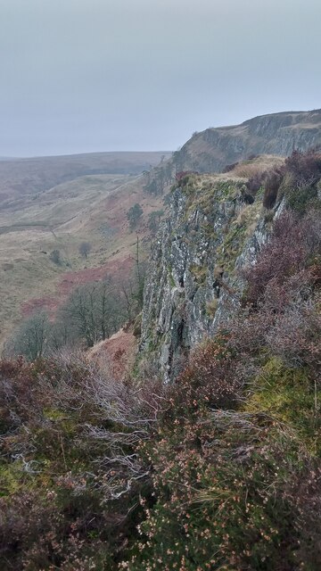
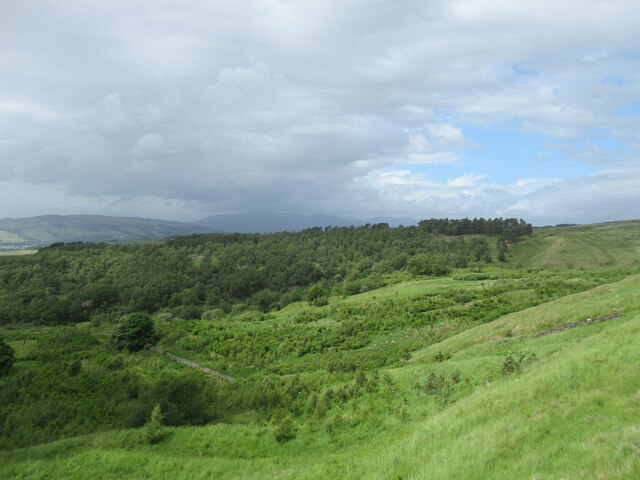
Square Wood is a picturesque forest located in Dunbartonshire, Scotland. Covering an area of approximately 100 acres, it is a popular destination for nature lovers and outdoor enthusiasts. The wood is situated just a few miles away from the town of Dunbarton, making it easily accessible for both locals and tourists.

The forest is characterized by its dense and diverse vegetation, consisting mainly of various species of native trees such as oak, birch, and pine. These trees provide a habitat for numerous bird species and small mammals, making it an ideal spot for wildlife observation and birdwatching.

Square Wood offers a network of well-maintained walking trails that wind through the forest, allowing visitors to explore its natural beauty at their own pace. The paths are suitable for all fitness levels and provide a serene environment for a leisurely stroll or a more vigorous hike. Along the trails, visitors can discover tranquil ponds, babbling brooks, and breathtaking panoramic views of the surrounding countryside.

The wood is also home to a rich variety of plant species, including wildflowers and ferns, which add to the charm and beauty of the landscape. Nature enthusiasts will find ample opportunities for photography and botanical exploration.

With its peaceful atmosphere and stunning natural scenery, Square Wood offers a welcome escape from the hustle and bustle of everyday life. Whether you are seeking solace in nature or looking to engage in outdoor activities, this forest is a must-visit destination in Dunbartonshire.

If you have any feedback on the listing, please let us know in the comments section below.

Square Wood Images

Images are sourced within 2km of 55.96579/-4.5334294 or Grid Reference NS4177. Thanks to Geograph Open Source API. All images are credited.

Lang Craigs, Kilpatrick Hills There is a footpath running alongside a fence (for the most part) close to the edge of this steep impressive escarpment.
The Kilpatrick Hills, though only reaching around 400 metres at their highest, have the feel of something a bit bigger. The hills take their name from a village on the Western outskirts of Glasgow called Old Kilpatrick, which translates as 'old church of Patrick'. It is said by some that St Patrick - the patron saint of Ireland and credited with founding Christianity there - grew up near the village before being kidnapped (for whatever reason!) by Irish pirates.
Lang Craigs, Kilpatrick Hills
There is a footpath running alongside a fence (for the most part) close to the edge of this steep impressive escarpment. The Kilpatrick Hills, though only reaching around 400 metres at their highest, have the feel of something a bit bigger. The hills take their name from a village on the Western outskirts of Glasgow called Old Kilpatrick, which translates as 'old church of Patrick'. It is said by some that St Patrick - the patron saint of Ireland and credited with founding Christianity there - grew up near the village before being kidnapped (for whatever reason!) by Irish pirates.
View towards Dumbarton from path by Lang Craigs The area of woodland and grassland beneath Lang Craigs is managed by Forestry and Land Scotland, an agency of the Scottish Government.

Dumbarton Rock is visible beside the Firth of Clyde in the distance.
View towards Dumbarton from path by Lang Craigs
The area of woodland and grassland beneath Lang Craigs is managed by Forestry and Land Scotland, an agency of the Scottish Government. Dumbarton Rock is visible beside the Firth of Clyde in the distance.
Path below Lang Craigs Extensive tree plantings have been made by Forestry and Land Scotland (who manage the site) in this area beneath the basalt lava escarpment of the Lang Craigs.
Path below Lang Craigs
Extensive tree plantings have been made by Forestry and Land Scotland (who manage the site) in this area beneath the basalt lava escarpment of the Lang Craigs.
Bench below the Lang Craigs The basalt lava escarpment of the Lang Craigs looms over the network of paths below, managed by Forestry and Land Scotland, an agency of the Scottish Government.
Bench below the Lang Craigs
The basalt lava escarpment of the Lang Craigs looms over the network of paths below, managed by Forestry and Land Scotland, an agency of the Scottish Government.
Black Wood viewed from the path below Lang Craigs An incoming rain shower can be seen over the Luss Hills in the distance.
Black Wood viewed from the path below Lang Craigs
An incoming rain shower can be seen over the Luss Hills in the distance.
Path below the Lang Craigs The path passes through a collapsed section of drystane dyke here, and can be followed on to Doughnot Hill.
Path below the Lang Craigs
The path passes through a collapsed section of drystane dyke here, and can be followed on to Doughnot Hill.
Path below northern end of the Lang Craigs A section of old rusty fencing can be seen here.
Path below northern end of the Lang Craigs
A section of old rusty fencing can be seen here.
Young trees by the Overtoun Burn Looking over an area of fairly new plantings towards the distant Luss Hills, where a rain shower looms.
Young trees by the Overtoun Burn
Looking over an area of fairly new plantings towards the distant Luss Hills, where a rain shower looms.
The Depths of Auchenreoch Glen This is NOT an aerial shot; it is taken from the rim of the gorge. The impressive depth can be gauged by noticing the small white specks towards the top of the picture. They are in fact sheep.

The depth attracts a micro climate. Above the rim there are almost no trees or bushes. Lower down there is an abundance of yellow gorse bushes. A few weeks later there is a dazzling display of white May blossom from the many Hawthorn Trees.

This shot is taken about 100 metres upstream of where Auchenreoch Glen joins Murroch Burn.

Substantial footwear is required to access the area. Start at Garshake Road in Dumbarton and following the footpath which skirts to the left of Marylands Farm, past the remains of the WWII Starfish Shelter and eventually up onto the moors.
The Depths of Auchenreoch Glen
This is NOT an aerial shot; it is taken from the rim of the gorge. The impressive depth can be gauged by noticing the small white specks towards the top of the picture. They are in fact sheep. The depth attracts a micro climate. Above the rim there are almost no trees or bushes. Lower down there is an abundance of yellow gorse bushes. A few weeks later there is a dazzling display of white May blossom from the many Hawthorn Trees. This shot is taken about 100 metres upstream of where Auchenreoch Glen joins Murroch Burn. Substantial footwear is required to access the area. Start at Garshake Road in Dumbarton and following the footpath which skirts to the left of Marylands Farm, past the remains of the WWII Starfish Shelter and eventually up onto the moors.
Remains of an ancient farmhouse This a view along the length of the faint traces of an ancient farm building. For the main description, see <a href="https://www.geograph.org.uk/photo/2357037">NS4277 : Remains of an ancient farmhouse</a>.

In the present view, the building's near end wall is located just in front of the area of brown tufts of grass in the foreground. The building takes up about half of the width of the image, and, from either end of the area of brown tufts, traces of the long side-walls of the building recede into the distance.

This view makes it clearer that the building is located almost at the edge of a fairly steep stream valley, which is just to the north (right) of the ruin.

The hills on the skyline, in the right-hand side of the image, are Carman Hill (<a href="https://www.geograph.org.uk/gridref/NS3779">NS3779</a>) and the adjacent muirs to the north. The trees in the middle distance, partly obscured by the grassy foreground area, are alongside the Garshake Burn. The more distant area of woodland at the left-hand edge of the image is Square Wood (see <a href="https://www.geograph.org.uk/photo/2205323">NS4177 : The edge of Square Wood</a>).
Remains of an ancient farmhouse
This a view along the length of the faint traces of an ancient farm building. For the main description, see NS4277 : Remains of an ancient farmhouse. In the present view, the building's near end wall is located just in front of the area of brown tufts of grass in the foreground. The building takes up about half of the width of the image, and, from either end of the area of brown tufts, traces of the long side-walls of the building recede into the distance. This view makes it clearer that the building is located almost at the edge of a fairly steep stream valley, which is just to the north (right) of the ruin. The hills on the skyline, in the right-hand side of the image, are Carman Hill (NS3779) and the adjacent muirs to the north. The trees in the middle distance, partly obscured by the grassy foreground area, are alongside the Garshake Burn. The more distant area of woodland at the left-hand edge of the image is Square Wood (see NS4177 : The edge of Square Wood).
Remains of an ancient farmhouse This long-abandoned farmstead does not appear, even as a ruin, on the first-edition OS map (surveyed in 186o), nor on any subsequent OS maps. It is not even shown on Roy's Military Survey of Scotland (1740s-50s); evidently the farmstead had already been abandoned by that early date. Since it is not shown on any maps, its name is, for now, unknown.

[This farmstead had not hitherto been reported to WoSAS, so I submitted a report for their database. The ruin lies within an area that has recently been purchased by the Woodland Trust Scotland, so additional details may well come to light; incidentally, the WTS have been made aware of the site, and are, I am pleased to say, amenable to its preservation.]

The farm building itself is located in the lower half of the photograph, and fills most of the width of the image, but it is not very easy to pick out on the ground, let alone in a photograph. Traces of the more distant of the two long side walls follow the far edge of the green area that makes up the foreground (specifically, the lower half) of the image; the other side wall is just in front of it. One of the end walls is beside the line of tufts of tall grass on the right. The other end wall is beside the taller tufts at the left-hand edge of the image.

For a view along the length of the building from its eastern end, see <a href="https://www.geograph.org.uk/photo/2357007">NS4277 : Remains of an ancient farmhouse</a>.

No exposed stone is visible here. The footings of the building are apparent only as indistinct ridges in the grass. Nevertheless, it was possible to follow the building's outline on the ground. It measured approximately 9.4 metres long by 4.1 metres wide, with its long axis oriented WNW-ESE. At least one cross-wall was also apparent, dividing the building into rooms; the largest room was at the western end (on the left, in this image), and was 5.5 metres long (that figure includes the width of the western wall of the building and that of the dividing cross-wall). There may have been another cross-wall very close to the eastern end of the building, creating a narrow space there, but it was hard to tell, given the faintness of the ruins.

The building is set on high ground between the Overtoun Burn (which is to the south-east) and the Garshake Burn and the Black Burn (to the north-west). Only a metre or two to the north of the building is the steep valley of a stream that drains into the Garshake Burn; the building is perched almost at the edge, and would certainly have commanded a fine view to the west and the north.

The farm building lies at the northern corner of a more or less rectangular enclosure that has the same orientation as the building, and which measures 85 metres (WNW-ESE) by 45 metres. This enclosure is very faint on the ground; see the end-note for an annotated satellite image(*). The full extent of the farmstead may be much greater.

[(*) For a much more revealing satellite view of these remains, I would recommend using the "Historical Imagery" function in Google Earth, and looking at the imagery for this area that is dated Jan 28th, 2005. In that dataset alone, the sun's angle of illumination is exceptionally shallow, making the farm building visible, revealing the rectangular enclosure to the south, and even showing cultivation patterns within the enclosure. In satellite images taken on other dates, these features are more or less invisible.]

More obvious, both on the ground and in satellite imagery, are the outlines of some irregular sub-enclosures that are located within the eastern half of the main enclosure.

Just to the south-west of the enclosure, a braided trackway (a closely-grouped and intertwining set of old tracks) passes nearby. Many of the tracks are worn fairly deep, but all of them are seen most clearly in the 2005 satellite imagery that was mentioned above. These tracks are probably at least as old as the farmstead, and they lead for a considerable distance to the north-east, mainly in the direction of Meikle White Hill (<a href="https://www.geograph.org.uk/gridref/NS4478">NS4478</a>), where lime-kiln ruins have been reported.

[A similar system of braided trackways begins near <a href="https://www.geograph.org.uk/gridref/NS42087781">NS42087781</a>, on the other side of the Garshake Burn, and forms a very extensive network there, leading to many sites where there are traces of limestone quarrying or of ruined lime-kilns (the lime-burning industry flourished in this area in the eighteenth century). For further details, see <a href="https://www.geograph.org.uk/photo/1692778">NS4278 : Signs of former industry at the Spouts Burn</a>, which discusses one of the sites to which these tracks lead.]
Remains of an ancient farmhouse
This long-abandoned farmstead does not appear, even as a ruin, on the first-edition OS map (surveyed in 186o), nor on any subsequent OS maps. It is not even shown on Roy's Military Survey of Scotland (1740s-50s); evidently the farmstead had already been abandoned by that early date. Since it is not shown on any maps, its name is, for now, unknown. [This farmstead had not hitherto been reported to WoSAS, so I submitted a report for their database. The ruin lies within an area that has recently been purchased by the Woodland Trust Scotland, so additional details may well come to light; incidentally, the WTS have been made aware of the site, and are, I am pleased to say, amenable to its preservation.] The farm building itself is located in the lower half of the photograph, and fills most of the width of the image, but it is not very easy to pick out on the ground, let alone in a photograph. Traces of the more distant of the two long side walls follow the far edge of the green area that makes up the foreground (specifically, the lower half) of the image; the other side wall is just in front of it. One of the end walls is beside the line of tufts of tall grass on the right. The other end wall is beside the taller tufts at the left-hand edge of the image. For a view along the length of the building from its eastern end, see NS4277 : Remains of an ancient farmhouse. No exposed stone is visible here. The footings of the building are apparent only as indistinct ridges in the grass. Nevertheless, it was possible to follow the building's outline on the ground. It measured approximately 9.4 metres long by 4.1 metres wide, with its long axis oriented WNW-ESE. At least one cross-wall was also apparent, dividing the building into rooms; the largest room was at the western end (on the left, in this image), and was 5.5 metres long (that figure includes the width of the western wall of the building and that of the dividing cross-wall). There may have been another cross-wall very close to the eastern end of the building, creating a narrow space there, but it was hard to tell, given the faintness of the ruins. The building is set on high ground between the Overtoun Burn (which is to the south-east) and the Garshake Burn and the Black Burn (to the north-west). Only a metre or two to the north of the building is the steep valley of a stream that drains into the Garshake Burn; the building is perched almost at the edge, and would certainly have commanded a fine view to the west and the north. The farm building lies at the northern corner of a more or less rectangular enclosure that has the same orientation as the building, and which measures 85 metres (WNW-ESE) by 45 metres. This enclosure is very faint on the ground; see the end-note for an annotated satellite image(*). The full extent of the farmstead may be much greater. [(*) For a much more revealing satellite view of these remains, I would recommend using the "Historical Imagery" function in Google Earth, and looking at the imagery for this area that is dated Jan 28th, 2005. In that dataset alone, the sun's angle of illumination is exceptionally shallow, making the farm building visible, revealing the rectangular enclosure to the south, and even showing cultivation patterns within the enclosure. In satellite images taken on other dates, these features are more or less invisible.] More obvious, both on the ground and in satellite imagery, are the outlines of some irregular sub-enclosures that are located within the eastern half of the main enclosure. Just to the south-west of the enclosure, a braided trackway (a closely-grouped and intertwining set of old tracks) passes nearby. Many of the tracks are worn fairly deep, but all of them are seen most clearly in the 2005 satellite imagery that was mentioned above. These tracks are probably at least as old as the farmstead, and they lead for a considerable distance to the north-east, mainly in the direction of Meikle White Hill (NS4478), where lime-kiln ruins have been reported. [A similar system of braided trackways begins near NS42087781, on the other side of the Garshake Burn, and forms a very extensive network there, leading to many sites where there are traces of limestone quarrying or of ruined lime-kilns (the lime-burning industry flourished in this area in the eighteenth century). For further details, see NS4278 : Signs of former industry at the Spouts Burn, which discusses one of the sites to which these tracks lead.]
Path to Overtoun Estate This path is a remnant of an <a href="https://www.geograph.org.uk/photo/2939932">NS4176 : Avenue to Overtoun House</a> that was built in the nineteenth century.

The path leads from <a href="https://www.geograph.org.uk/photo/141488">NS4175 : Dumbarton, Old Overtoun Estate Gateway</a> to one of the entrances of the present-day Overtoun Estate (<a href="https://www.geograph.org.uk/photo/1018442">NS4175 : Pedestrian access to Overtoun Estate</a>), and forms part of two circular walks, namely, The Crags Circular Path and Overtoun House Circular Path.

For a view from further along the path, see <a href="https://www.geograph.org.uk/photo/2390253">NS4175 : Path to Overtoun Estate</a>.
Path to Overtoun Estate
This path is a remnant of an NS4176 : Avenue to Overtoun House that was built in the nineteenth century. The path leads from NS4175 : Dumbarton, Old Overtoun Estate Gateway to one of the entrances of the present-day Overtoun Estate (NS4175 : Pedestrian access to Overtoun Estate), and forms part of two circular walks, namely, The Crags Circular Path and Overtoun House Circular Path. For a view from further along the path, see NS4175 : Path to Overtoun Estate.
Path to Overtoun Estate This photograph was taken just a little further along the path that is shown in <a href="https://www.geograph.org.uk/photo/2390227">NS4175 : Path to Overtoun Estate</a>; see that item for further information.

Visible not far ahead, in the present photograph, are the backs of some of the houses on <a href="https://www.geograph.org.uk/photo/2199510">NS4176 : MacPhie Road, High Overtoun</a>. There is an extensive patch of Butterbur on the right; the leaves are much larger when fully grown.

This path is a remnant of an <a href="https://www.geograph.org.uk/photo/2939932">NS4176 : Avenue to Overtoun House</a> that was built in the nineteenth century.
Path to Overtoun Estate
This photograph was taken just a little further along the path that is shown in NS4175 : Path to Overtoun Estate; see that item for further information. Visible not far ahead, in the present photograph, are the backs of some of the houses on NS4176 : MacPhie Road, High Overtoun. There is an extensive patch of Butterbur on the right; the leaves are much larger when fully grown. This path is a remnant of an NS4176 : Avenue to Overtoun House that was built in the nineteenth century.
The Crags Circular Path This is part of a signposted route. Part of the escarpment of the Kilpatrick Hills can be seen in the background, on the right.
The Crags Circular Path
This is part of a signposted route. Part of the escarpment of the Kilpatrick Hills can be seen in the background, on the right.
The Crags Circular Path Roundwood Hill, formerly the site of a plantation, is near the centre of the image; see <a href="https://www.geograph.org.uk/photo/1213685">NS4377 : Roundwood Hill</a>. The escarpment of the Kilpatrick Hills is on the right.
The Crags Circular Path
Roundwood Hill, formerly the site of a plantation, is near the centre of the image; see NS4377 : Roundwood Hill. The escarpment of the Kilpatrick Hills is on the right.
Ballagan Beds in Overtoun Glen In the sides of the glen of the Overtoun Burn, examples of Ballagan Beds are visible, with lighter layers of cementstone conspicuous among the layers of shale (compare <a href="https://www.geograph.org.uk/photo/1942115">NS4178 : Ballagan Beds in Auchenreoch Glen</a>). The formation, precipitated out from shallow seas or lagoons, is of Lower Carboniferous age.

For further context, see a more distant view: <a href="https://www.geograph.org.uk/photo/2394153">NS4377 : The glen of the Overtoun Burn</a>.

For further examples, and for nearby parts of the glen, see, for example, <a href="https://www.geograph.org.uk/photo/830997">NS4377 : Rocky side of Overtoun Glen</a>, <a href="https://www.geograph.org.uk/photo/831003">NS4377 : Overtoun Burn and Glen</a>, and <a href="https://www.geograph.org.uk/photo/830994">NS4377 : Overtoun Glen</a>.

The geological type location, where the best example of the Ballagan Formation can be seen, is Ballagan Glen (<a href="https://www.geograph.org.uk/gridref/NS5779">NS5779</a>)
Ballagan Beds in Overtoun Glen
In the sides of the glen of the Overtoun Burn, examples of Ballagan Beds are visible, with lighter layers of cementstone conspicuous among the layers of shale (compare NS4178 : Ballagan Beds in Auchenreoch Glen). The formation, precipitated out from shallow seas or lagoons, is of Lower Carboniferous age. For further context, see a more distant view: NS4377 : The glen of the Overtoun Burn. For further examples, and for nearby parts of the glen, see, for example, NS4377 : Rocky side of Overtoun Glen, NS4377 : Overtoun Burn and Glen, and NS4377 : Overtoun Glen. The geological type location, where the best example of the Ballagan Formation can be seen, is Ballagan Glen (NS5779)
The glen of the Overtoun Burn The grey areas, with conspicuous banding, on the valley sides are examples of Ballagan Beds, with layers of cementstone and shale. For further details, and for a closer look at the formation on the left, from down inside the glen, see <a href="https://www.geograph.org.uk/photo/2394150">NS4377 : Ballagan Beds in Overtoun Glen</a>.
The glen of the Overtoun Burn
The grey areas, with conspicuous banding, on the valley sides are examples of Ballagan Beds, with layers of cementstone and shale. For further details, and for a closer look at the formation on the left, from down inside the glen, see NS4377 : Ballagan Beds in Overtoun Glen.
Show me another place!

Square Wood is located at Grid Ref: NS4177 (Lat: 55.96579, Lng: -4.5334294)

Unitary Authority: West Dunbartonshire

Police Authority: Argyll and West Dunbartonshire

What 3 Words

///free.studs.secures. Near Bonhill, West Dunbartonshire

Related Wikis

Dunbartonshire

Dunbartonshire (Scottish Gaelic: Siorrachd Dhùn Breatann) or the County of Dumbarton is a historic county, lieutenancy area and registration county in...

Bellsmyre

Bellsmyre is a large housing estate in the town of Dumbarton in West Dunbartonshire, Scotland. Located on the edge of the Kilpatrick Hills in the northeast...

Our Lady and St Patrick's High School

Our Lady & St Patrick's High School is a six-year co-educational comprehensive Roman Catholic school, situated in the Bellsmyre area of Dumbarton, Scotland...

Overtoun Bridge

Overtoun Bridge is a category B-listed structure over the Overtoun Burn on the approach road from the west to Overtoun House, near Dumbarton in West Dunbartonshire...

Nearby Amenities

Located within 500m of 55.96579,-4.5334294
West Dunbartonshire
Gns Classification: ADM1
Gns Uni: 6086804
Is In Country: United Kingdom
Is In Country Code: GB
Place: county
Source: GNS
Lat/Long: 55.966667/-4.533333
The data included in this document is from www.openstreetmap.org. The data is made available under ODbL.

Have you been to Square Wood?

Leave your review of Square Wood below (or comments, questions and feedback).