Tairlaw Plantation
Wood, Forest in Ayrshire
Scotland
Tairlaw Plantation

Tairlaw Plantation is a beautiful woodland area located in Ayrshire, Scotland. Covering an approximate area of 200 hectares, this plantation is known for its diverse range of trees and abundant wildlife. It is situated near the town of Cumnock and is easily accessible by road.
The woodland of Tairlaw Plantation primarily consists of mixed broadleaf and coniferous trees. These include species such as oak, beech, birch, and Scots pine, which provide a rich and varied habitat for numerous animals and birds. The plantation is managed by the Forestry Commission, ensuring the preservation and sustainable use of the woodland.
Visitors to Tairlaw Plantation can enjoy a range of recreational activities. There are well-maintained trails that wind through the woodland, offering picturesque views and opportunities for walking, jogging, or cycling. The plantation also features picnic areas and designated spots for birdwatching, making it a popular destination for nature enthusiasts.
The wildlife in Tairlaw Plantation is plentiful and diverse. Red squirrels, roe deer, and foxes are often spotted within the woodland, while a variety of bird species, including woodpeckers, owls, and finches, can be heard and seen throughout the year.
Overall, Tairlaw Plantation is a tranquil and scenic destination, perfect for those seeking a peaceful retreat in nature. With its well-managed trails, diverse tree species, and abundant wildlife, it offers a unique opportunity to explore and appreciate the natural beauty of Ayrshire.
If you have any feedback on the listing, please let us know in the comments section below.
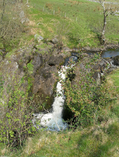
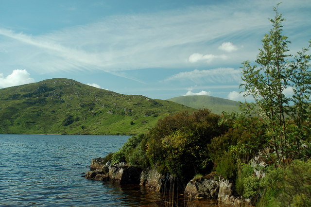
Tairlaw Plantation Images
Images are sourced within 2km of 55.241849/-4.5166621 or Grid Reference NX4097. Thanks to Geograph Open Source API. All images are credited.


Tairlaw Plantation is located at Grid Ref: NX4097 (Lat: 55.241849, Lng: -4.5166621)
Unitary Authority: South Ayrshire
Police Authority: Ayrshire
What 3 Words
///managers.planting.streak. Near Bellsbank, East Ayrshire
Nearby Locations
Related Wikis

Stinchar Falls
Stinchar Falls is a waterfall of Scotland. It is located on the Stinchar Burn, east of Barr in Ayrshire. == See also == Waterfalls of Scotland == References ==

Loch Brecbowie
Loch Brecbowie is a Scottish loch located in the Ayrshire region, near the town of Girvan.The small, freshwater loch contains four small islands. It is...
Tairlaw Linn
Tairlaw Linn is a waterfall of Scotland, near Straiton, South Ayrshire. == See also == Waterfalls of Scotland == References ==

Drunmore Linn
Drunmore Linn is a waterfall of Scotland, near Straiton, South Ayrshire. == See also == Waterfalls of Scotland == References ==

Shalloch on Minnoch
Shalloch on Minnoch is a hill in the Range of the Awful Hand, a sub-range of the Galloway Hills range, part of the Southern Uplands of Scotland. It is...
Loch Macaterick
Loch Macaterick is a loch in East Ayrshire, Scotland within Galloway Forest Park and Merrick Kells SSSI. The loch is situated to the north of Macaterick...

Straiton
Straiton is a village on the River Girvan in South Ayrshire in Scotland. It lies in the hills between Kirkmichael, Dalmellington, Crosshill, and Maybole...
Craigmalloch
Craigmalloch is a small settlement in East Ayrshire, Scotland. == External links == Scotland's places Royal Commission on Ancient and Historical Monuments...
Nearby Amenities
Located within 500m of 55.241849,-4.5166621Have you been to Tairlaw Plantation?
Leave your review of Tairlaw Plantation below (or comments, questions and feedback).