Alresford

Settlement in Essex Tendring

England

Alresford

Across Alresford Creek I wouldn't fancy fording here!!
Across Alresford Creek Credit: Glyn Baker

Alresford is a small village located in the county of Essex, England. Situated approximately 15 miles north-east of Chelmsford, it lies within the borough of Colchester. With a population of around 1,500 residents, Alresford is a close-knit community known for its picturesque landscapes and peaceful atmosphere.

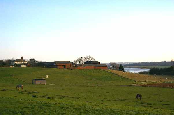
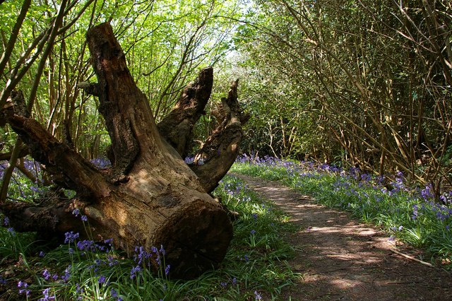
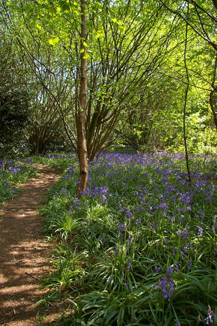
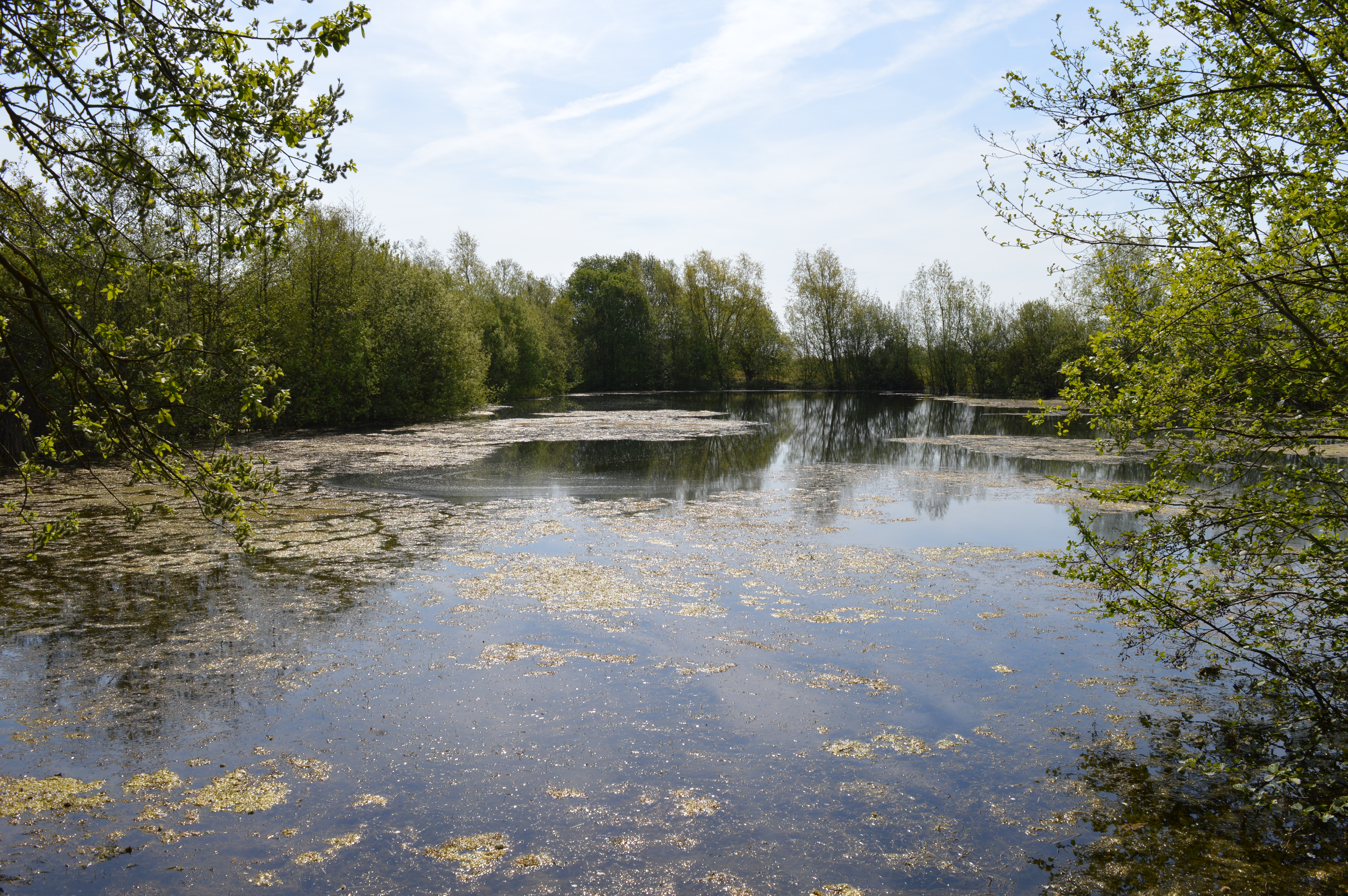
The village is surrounded by beautiful countryside, including rolling hills, meadows, and charming woodland areas. The Alresford Creek, which runs through the village, adds to its scenic appeal. The nearby Colne Valley provides opportunities for outdoor activities such as walking, hiking, and birdwatching.

Alresford boasts a rich history, with evidence of human settlement dating back to the Roman period. The village is home to several historic buildings, including the 12th-century St. Andrew's Church, which features stunning architecture and intricate stained glass windows. The village also has a number of well-preserved cottages and houses that showcase traditional English architecture.

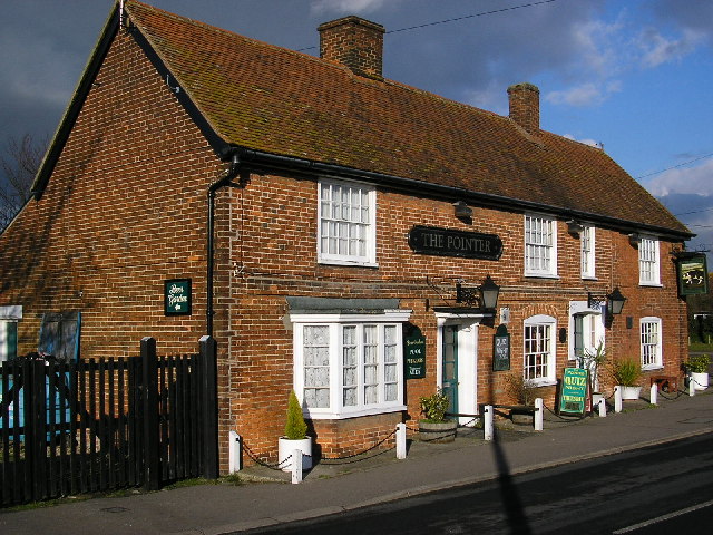
For amenities, Alresford offers a range of facilities to cater to the needs of its residents. These include a primary school, a village hall, a local pub, and a small convenience store. The village is well-connected to nearby towns and cities via road links, making it easily accessible for commuters.

Overall, Alresford is a peaceful and idyllic village that offers a serene lifestyle amidst the beauty of the Essex countryside. Its rich history, natural surroundings, and friendly community make it an attractive place to live for those seeking a rural retreat.

If you have any feedback on the listing, please let us know in the comments section below.

Alresford Images

Images are sourced within 2km of 51.85276/0.99770264 or Grid Reference TM0621. Thanks to Geograph Open Source API. All images are credited.

Across Alresford Creek I wouldn't fancy fording here!!
Across Alresford Creek
I wouldn't fancy fording here!!
Alresford Tidal Crossing This tidal ford is approached from the aptly named Ford Lane. Seen here at low-tide. A video showing that it is possible cross the ford with the right equipment can be seen at:
<span class="nowrap"><a title="https://youtu.be/3-UXHj5ZVEo" rel="nofollow ugc noopener" href="https://youtu.be/3-UXHj5ZVEo">Link</a><img style="margin-left:2px;" alt="External link" title="External link - shift click to open in new window" src="https://s1.geograph.org.uk/img/external.png" width="10" height="10"/></span>
Alresford Tidal Crossing
This tidal ford is approached from the aptly named Ford Lane. Seen here at low-tide. A video showing that it is possible cross the ford with the right equipment can be seen at: LinkExternal link
The Ford To judge by the map, this typical Essex weatherboarded house is called "The Ford". (Note the roof line!) It stands beside an ancient ford across Alresford Creek, a branch of the River Colne estuary. In the distance is <a href="https://www.geograph.org.uk/photo/122980">TM0718 : All Saints Church, Brightlingsea</a> which stands in <a href="https://www.geograph.org.uk/gridref/TM0718">TM0718</a> beside Brightlingsea Hall but  2 km from Brightlingsea town centre.
The Ford
To judge by the map, this typical Essex weatherboarded house is called "The Ford". (Note the roof line!) It stands beside an ancient ford across Alresford Creek, a branch of the River Colne estuary. In the distance is TM0718 : All Saints Church, Brightlingsea which stands in TM0718 beside Brightlingsea Hall but 2 km from Brightlingsea town centre.
Ruins of St Peter's Church Many Essex churches are remote from the villages they serve but stand near the house of the lord of the manor who paid for building the church. Perhaps in this case the original manor house has disappeared because this church stands about a kilometre away from Alresford village and from Alresford Hall. The church, built circa 1320 was a remodelling of a 10/11th century church which in turn incorporated tiles from the remains of a Roman villa nearby. It was destroyed by fire in 1971.
Ruins of St Peter's Church
Many Essex churches are remote from the villages they serve but stand near the house of the lord of the manor who paid for building the church. Perhaps in this case the original manor house has disappeared because this church stands about a kilometre away from Alresford village and from Alresford Hall. The church, built circa 1320 was a remodelling of a 10/11th century church which in turn incorporated tiles from the remains of a Roman villa nearby. It was destroyed by fire in 1971.
The Pointer Public house in Wivenhoe Road, Alresford
The Pointer
Public house in Wivenhoe Road, Alresford
Radio mast and pylon In Cockaynes Lane, Alresford. The mast is mainly for data communication for a nearby electricity substation.
Radio mast and pylon
In Cockaynes Lane, Alresford. The mast is mainly for data communication for a nearby electricity substation.
Sewage works Beside the Tenpenny Brook, just south of St Osyth Road, Alresford
Sewage works
Beside the Tenpenny Brook, just south of St Osyth Road, Alresford
Frating Parish Church Snowdrops in the churchyard of Frating Parish Church. The leaning gravestones suggest that the graves are about to open as in a Stanley Spencer painting <span class="nowrap"><a title="http://www.leninimports.com/stanley_spencer_gallery_4.jpg" rel="nofollow ugc noopener" href="http://www.leninimports.com/stanley_spencer_gallery_4.jpg">Link</a><img style="margin-left:2px;" alt="External link" title="External link - shift click to open in new window" src="https://s1.geograph.org.uk/img/external.png" width="10" height="10"/></span> . The church is now a private house. No one seems to know what its dedication was.
Frating Parish Church
Snowdrops in the churchyard of Frating Parish Church. The leaning gravestones suggest that the graves are about to open as in a Stanley Spencer painting LinkExternal link . The church is now a private house. No one seems to know what its dedication was.
Plumptons Track This is the track to Plumptons Farm near Alresford. It is part of a footpath that runs from Ford Lane to Thorrington Mill. <a href="https://www.geograph.org.uk/photo/122980">TM0718 : All Saints Church, Brightlingsea</a> tower can be seen above the trees to the right.
Plumptons Track
This is the track to Plumptons Farm near Alresford. It is part of a footpath that runs from Ford Lane to Thorrington Mill. TM0718 : All Saints Church, Brightlingsea tower can be seen above the trees to the right.
Marsh Farm Paddock This is a view across a paddock towards Marsh Farm near Alresford and the River Colne beyond.
Marsh Farm Paddock
This is a view across a paddock towards Marsh Farm near Alresford and the River Colne beyond.
Alresford Grange This is Alresford Grange taken from the bridle path from Wivenhoe Road to Ford Lane.
Alresford Grange
This is Alresford Grange taken from the bridle path from Wivenhoe Road to Ford Lane.
Towards the Seaside This is the Railway line from Colchester to Clacton at Alresford looking towards Clacton
Towards the Seaside
This is the Railway line from Colchester to Clacton at Alresford looking towards Clacton
Hockley Place Hockley Place is a large farmhouse southeast of Frating
Hockley Place
Hockley Place is a large farmhouse southeast of Frating
Captains Wood Path This view of the footpath through Captains Wood near Frating will be really spectacular in a few days when the bluebells are out. Now you can judge for yourself at <a href="https://www.geograph.org.uk/photo/419032">TM0722 : Bluebells and Captains Wood</a>
Captains Wood Path
This view of the footpath through Captains Wood near Frating will be really spectacular in a few days when the bluebells are out. Now you can judge for yourself at TM0722 : Bluebells and Captains Wood
Bluebells and Captains Wood Just 19 days separate this picture and <a href="https://www.geograph.org.uk/photo/395223">TM0722 : Captains Wood Path</a> both were taken in full sun and at roughly the same time of day. I only wish I could put the heady scent on the webpage.
Bluebells and Captains Wood
Just 19 days separate this picture and TM0722 : Captains Wood Path both were taken in full sun and at roughly the same time of day. I only wish I could put the heady scent on the webpage.
Hyacinthoides non-scripta You can tell these are Native Bluebells (Hyacinthoides non-scripta) because they are low to the ground a deep blue to violet in colour, the vividness of which is almost impossible to capture in a photo. They have a heady scent distinctly absent in their Spanish cousins <a href="https://www.geograph.org.uk/photo/422936">TM2420 : Spanish Bluebells</a>. Hybrid Bells <a href="https://www.geograph.org.uk/photo/426187">TQ5880 : Hyacinthoides x massartiana</a> are sometimes difficult to tell from natives. For more info see
<span class="nowrap"><a title="http://www.nhm.ac.uk/nature-online/british-natural-history/survey-bluebells/bluebell-identification/index.html" rel="nofollow ugc noopener" href="http://www.nhm.ac.uk/nature-online/british-natural-history/survey-bluebells/bluebell-identification/index.html">Link</a><img style="margin-left:2px;" alt="External link" title="External link - shift click to open in new window" src="https://s1.geograph.org.uk/img/external.png" width="10" height="10"/></span>
Hyacinthoides non-scripta
You can tell these are Native Bluebells (Hyacinthoides non-scripta) because they are low to the ground a deep blue to violet in colour, the vividness of which is almost impossible to capture in a photo. They have a heady scent distinctly absent in their Spanish cousins TM2420 : Spanish Bluebells. Hybrid Bells TQ5880 : Hyacinthoides x massartiana are sometimes difficult to tell from natives. For more info see LinkExternal link
Red Campion This is Red Campion (Silene dioica) growing on the edge of the footpath that leads to Captains Wood.
Red Campion
This is Red Campion (Silene dioica) growing on the edge of the footpath that leads to Captains Wood.
Path in Captains Wood About half the world's bluebells <a href="https://www.geograph.org.uk/photo/422951">TM0722 : Hyacinthoides non-scripta</a> grow in British woodlands
Path in Captains Wood
About half the world's bluebells TM0722 : Hyacinthoides non-scripta grow in British woodlands
Show me another place!

Alresford is located at Grid Ref: TM0621 (Lat: 51.85276, Lng: 0.99770264)

Administrative County: Essex

District: Tendring

Police Authority: Essex

What 3 Words

///quilt.deal.prowling. Near Alresford, Essex

Nearby Locations

Alresford

Related Wikis

Alresford railway station (Essex)

Alresford railway station is on the Sunshine Coast Line, a branch of the Great Eastern Main Line, in the East of England, serving the village of Alresford...

Alresford, Essex

Alresford ( or ) is a village and electoral ward in Essex, England. It is centred 9 km (5.6 mi) southeast of Colchester and is 39 km (24 mi) northeast...

Cockaynes Wood

Cockaynes Wood is a 20.2-hectare (50-acre) nature reserve between Wivenhoe and Alresford in Essex, United Kingdom. It is managed by the Essex Wildlife...

Frating

Frating is a village and small civil parish of the Tendring district of Essex, England. It is about 8 kilometres (5 mi) east of Colchester and 15 kilometres...

Beth Chatto Gardens

The Beth Chatto Gardens, now known as Beth Chatto's Plants & Gardens, are an informal collection of historically significant gardens, with National Heritage...

Wivenhoe Gravel Pit

Wivenhoe Gravel Pit is a 2.1-hectare (5.2-acre) geological Site of Special Scientific Interest north of Wivenhoe in Essex. It is a Geological Conservation...

Fingringhoe Wick

Fingringhoe Wick is a 48.6-hectare (120-acre) nature reserve in Fingringhoe in Essex. It is managed by the Essex Wildlife Trust, which runs a visitor centre...

Thorington railway station

Thorington railway station (also Thorrington railway station) was a station in Thorrington, Essex on the line (now called the Sunshine Coast Line) from...

Nearby Amenities

Located within 500m of 51.85276,0.99770264
Alresford
Place: village
Lat/Long: 51.8519359/1.0023071
Crossing
Crossing Ref: zebra
Lat/Long: 51.8527343/0.9979623
Mini Roundabout
Direction: clockwise
Lat/Long: 51.8527456/1.0020954
Alresford LC
Railway: level_crossing
Lat/Long: 51.853987/0.997668
Coach Road LC
Railway: level_crossing
Lat/Long: 51.8538046/1.0020913
Mini Roundabout
Direction: clockwise
Lat/Long: 51.852733/1.002367
Post Box
Mapillary: 737918576904217
Post Box Type: pillar
Postal Code: CO7 8BX
Ref: CO7 409
Survey Date: 2021-04-24
Lat/Long: 51.8542338/0.9977048
Post Box
Postal Code: CO7 8AG
Ref: CO7 62
Lat/Long: 51.853112/0.992532
Post Box
Brand: Royal Mail
Brand Wikidata: Q638098
Operator: Royal Mail
Operator Wikidata: Q638098
Post Box Mounting: pier
Post Box Type: lamp
Postal Code: CO7 8EA
Ref: CO7 243
Lat/Long: 51.8528957/1.0022835
Bus Stop
Wivenhoe Road
Naptan AtcoCode: 150032002030
Naptan Bearing: E
Naptan CommonName: Wivenhoe Road
Naptan Crossing: Conifer Close
Naptan Indicator: E-bound
Naptan Landmark: Wivenhoe Road
Naptan NaptanCode: esxgjgta
Naptan Street: Wivenhoe Road
Naptan Verified: no
Public Transport: platform
Source: naptan_import
Lat/Long: 51.8529611/0.9924816
Wivenhoe Road
Naptan AtcoCode: 1500320020Y0
Naptan Bearing: W
Naptan BusStopType: CUS
Naptan CommonName: Wivenhoe Road
Naptan Crossing: Conifer Close
Naptan Indicator: W-bound
Naptan Landmark: Wivenhoe Road
Naptan NaptanCode: esxgwjwa
Naptan Street: Wivenhoe Road
Naptan Verified: no
Public Transport: platform
Source: naptan_import
Lat/Long: 51.8528885/0.9925058
Bus Stop
Coach Road Corner
Naptan AtcoCode: 1500IM1280
Naptan Bearing: E
Naptan CommonName: Coach Road Corner
Naptan Crossing: Coach Road
Naptan Indicator: E-bound
Naptan Landmark: Coach Road Corner
Naptan NaptanCode: esxgtwmj
Naptan Street: Wivenhoe Road
Naptan Verified: no
Public Transport: platform
Source: naptan_import
Lat/Long: 51.8527209/1.0008458
Bus Stop
Coach Road Corner
Naptan AtcoCode: 1500IM1280B
Naptan Bearing: W
Naptan CommonName: Coach Road Corner
Naptan Crossing: Coach Road
Naptan Indicator: W-bound
Naptan Landmark: Coach Road Corner
Naptan NaptanCode: esxgtwmp
Naptan Street: Wivenhoe Road
Naptan Verified: no
Public Transport: platform
Source: naptan_import
Lat/Long: 51.8526623/1.0017739
Bus Stop
The Pointer
Naptan AtcoCode: 1500IM1281
Naptan Bearing: E
Naptan CommonName: The Pointer
Naptan Indicator: o/s
Naptan Landmark: The Pointer
Naptan NaptanCode: esxadjgt
Naptan Street: Wivenhoe Road
Naptan Verified: no
Public Transport: platform
Source: naptan_import
Lat/Long: 51.8527928/0.9973213
The Pointer
Naptan AtcoCode: 1500IM1281B
Naptan Bearing: W
Naptan BusStopType: CUS
Naptan CommonName: The Pointer
Naptan Indicator: Opp
Naptan Landmark: The Pointer
Naptan NaptanCode: esxjawja
Naptan Street: Wivenhoe Road
Naptan Verified: no
Public Transport: platform
Source: naptan_import
Lat/Long: 51.8527258/0.997128
Note: stopped here by PCSO during survey :)
Lat/Long: 51.8514364/1.0013431
Power: pole
Source: bing
Lat/Long: 51.8485263/0.9975197
Power: pole
Source: bing
Lat/Long: 51.8504879/0.9974601
Power: pole
Source: bing
Lat/Long: 51.8493943/0.9977393
Power: pole
Source: bing
Lat/Long: 51.849553/0.9977519
Addr Housenumber: 49A-51A
Addr Interpolation: odd
Addr Postcode: CO7 8BU
Entrance: home
Lat/Long: 51.8544181/0.9978333
Addr Housenumber: 57A
Addr Postcode: CO7 8BU
Entrance: home
Lat/Long: 51.8541266/0.9978991
Waste Basket
Lat/Long: 51.8529278/1.002279
Recycling
Lat/Long: 51.851696/1.0014523
Waste Basket
Waste: dog_excrement
Lat/Long: 51.8542968/1.0021876
Addr Housenumber: 45A-47A
Addr Interpolation: odd
Addr Postcode: CO7 8BU
Entrance: home
Lat/Long: 51.8545962/0.9976143
Addr Housenumber: 41A-43A
Addr Interpolation: odd
Addr Postcode: CO7 8BU
Entrance: home
Lat/Long: 51.8546994/0.9974974
Addr Housenumber: 53A-55A
Addr Interpolation: odd
Addr Postcode: CO7 8BU
Entrance: home
Lat/Long: 51.854235/0.9977984
Railway: level_crossing
Lat/Long: 51.8537832/1.0020887
Railway: level_crossing
Lat/Long: 51.8539656/0.9976654
Alresford
Naptan AtcoCode: 9100ALRESFD
Network: National Rail
Network Website: https://www.nationalrail.co.uk/stations/alr/
Network Wikidata: Q26334
Railway: station
Ref Crs: ALR
Wikidata: Q2063973
Wikipedia: en:Alresford railway station (Essex)
Lat/Long: 51.8539985/0.9970365
Defibrillator
Emergency: defibrillator
Lat/Long: 51.8518574/1.0014146
Sizzlers
Addr Postcode: CO7 8AQ
Fhrs Id: 1036066
Shop: kiosk
Lat/Long: 51.852859/0.9967746
Generator Method: photovoltaic
Generator Output Electricity: yes
Generator Source: solar
Generator Type: solar_photovoltaic_panel
Location: roof
Power: generator
Lat/Long: 51.8564139/0.9978461
Generator Method: photovoltaic
Generator Output Electricity: yes
Generator Source: solar
Generator Type: solar_photovoltaic_panel
Location: roof
Power: generator
Lat/Long: 51.855762/0.9966257
Generator Method: photovoltaic
Generator Output Electricity: yes
Generator Source: solar
Generator Type: solar_photovoltaic_panel
Location: roof
Power: generator
Lat/Long: 51.8548947/0.9969342
Generator Method: photovoltaic
Generator Output Electricity: yes
Generator Source: solar
Generator Type: solar_photovoltaic_panel
Location: roof
Power: generator
Lat/Long: 51.85457/0.9970388
Generator Method: photovoltaic
Generator Output Electricity: yes
Generator Source: solar
Generator Type: solar_photovoltaic_panel
Location: roof
Power: generator
Lat/Long: 51.8533308/0.9913981
Generator Method: photovoltaic
Generator Output Electricity: yes
Generator Source: solar
Generator Type: solar_photovoltaic_panel
Location: roof
Power: generator
Lat/Long: 51.8532877/0.9914491
Generator Method: photovoltaic
Generator Output Electricity: yes
Generator Source: solar
Generator Type: solar_photovoltaic_panel
Location: roof
Power: generator
Lat/Long: 51.8532744/0.991728
Generator Method: photovoltaic
Generator Output Electricity: yes
Generator Source: solar
Generator Type: solar_photovoltaic_panel
Location: roof
Power: generator
Lat/Long: 51.8526631/0.9926453
Generator Method: photovoltaic
Generator Output Electricity: yes
Generator Source: solar
Generator Type: solar_photovoltaic_panel
Location: roof
Power: generator
Lat/Long: 51.8526399/0.9929055
Generator Method: photovoltaic
Generator Output Electricity: yes
Generator Source: solar
Generator Type: solar_photovoltaic_panel
Location: roof
Power: generator
Lat/Long: 51.8532247/0.9962046
Generator Method: photovoltaic
Generator Output Electricity: yes
Generator Source: solar
Generator Type: solar_photovoltaic_panel
Location: roof
Power: generator
Lat/Long: 51.8535975/0.9979856
Generator Method: photovoltaic
Generator Output Electricity: yes
Generator Source: solar
Generator Type: solar_photovoltaic_panel
Location: roof
Power: generator
Lat/Long: 51.8545286/0.9982377
Generator Method: photovoltaic
Generator Output Electricity: yes
Generator Source: solar
Generator Type: solar_photovoltaic_panel
Location: roof
Power: generator
Lat/Long: 51.8547075/0.9999222
Generator Method: photovoltaic
Generator Output Electricity: yes
Generator Source: solar
Generator Type: solar_photovoltaic_panel
Location: roof
Power: generator
Lat/Long: 51.8560312/0.9983209
Generator Method: photovoltaic
Generator Output Electricity: yes
Generator Source: solar
Generator Type: solar_photovoltaic_panel
Location: roof
Power: generator
Lat/Long: 51.8569059/0.99967
Generator Method: photovoltaic
Generator Output Electricity: yes
Generator Source: solar
Generator Type: solar_photovoltaic_panel
Location: roof
Power: generator
Lat/Long: 51.8543844/1.0018963
Generator Method: photovoltaic
Generator Output Electricity: yes
Generator Source: solar
Generator Type: solar_photovoltaic_panel
Location: roof
Power: generator
Lat/Long: 51.8532918/1.0034278
Generator Method: photovoltaic
Generator Output Electricity: yes
Generator Source: solar
Generator Type: solar_photovoltaic_panel
Location: roof
Power: generator
Lat/Long: 51.8539719/1.0046107
Generator Method: photovoltaic
Generator Output Electricity: yes
Generator Source: solar
Generator Type: solar_photovoltaic_panel
Location: roof
Power: generator
Lat/Long: 51.8531899/1.0042164
Generator Method: photovoltaic
Generator Output Electricity: yes
Generator Source: solar
Generator Type: solar_photovoltaic_panel
Location: roof
Power: generator
Lat/Long: 51.853185/1.0043049
Generator Method: photovoltaic
Generator Output Electricity: yes
Generator Source: solar
Generator Type: solar_photovoltaic_panel
Location: roof
Power: generator
Lat/Long: 51.8528669/0.9999302
Generator Method: photovoltaic
Generator Output Electricity: yes
Generator Source: solar
Generator Type: solar_photovoltaic_panel
Location: roof
Power: generator
Lat/Long: 51.8528636/0.9999704
Generator Method: photovoltaic
Generator Output Electricity: yes
Generator Source: solar
Generator Type: solar_photovoltaic_panel
Location: roof
Power: generator
Lat/Long: 51.8528984/0.9990156
Generator Method: photovoltaic
Generator Output Electricity: yes
Generator Source: solar
Generator Type: solar_photovoltaic_panel
Location: roof
Power: generator
Lat/Long: 51.8506087/0.9979776
Generator Method: photovoltaic
Generator Output Electricity: yes
Generator Source: solar
Generator Type: solar_photovoltaic_panel
Location: roof
Power: generator
Lat/Long: 51.8513211/1.000185
Generator Method: photovoltaic
Generator Output Electricity: yes
Generator Source: solar
Generator Type: solar_photovoltaic_panel
Location: roof
Power: generator
Lat/Long: 51.8511455/1.0008073
Generator Method: photovoltaic
Generator Output Electricity: yes
Generator Source: solar
Generator Type: solar_photovoltaic_panel
Location: roof
Power: generator
Lat/Long: 51.8514222/1.0002869
Generator Method: photovoltaic
Generator Output Electricity: yes
Generator Source: solar
Generator Type: solar_photovoltaic_panel
Location: roof
Power: generator
Lat/Long: 51.8515713/1.0006893
Generator Method: photovoltaic
Generator Output Electricity: yes
Generator Source: solar
Generator Type: solar_photovoltaic_panel
Location: roof
Power: generator
Lat/Long: 51.8516425/1.0008609
Generator Method: photovoltaic
Generator Output Electricity: yes
Generator Source: solar
Generator Type: solar_photovoltaic_panel
Location: roof
Power: generator
Lat/Long: 51.8522994/1.0020532
Generator Method: photovoltaic
Generator Output Electricity: yes
Generator Source: solar
Generator Type: solar_photovoltaic_panel
Location: roof
Power: generator
Lat/Long: 51.8524717/1.0024112
Generator Method: photovoltaic
Generator Output Electricity: yes
Generator Source: solar
Generator Type: solar_photovoltaic_panel
Location: roof
Power: generator
Lat/Long: 51.8524659/1.0024568
Generator Method: photovoltaic
Generator Output Electricity: yes
Generator Source: solar
Generator Type: solar_photovoltaic_panel
Location: roof
Power: generator
Lat/Long: 51.8523384/1.004329
Generator Method: photovoltaic
Generator Output Electricity: yes
Generator Source: solar
Generator Type: solar_photovoltaic_panel
Location: roof
Power: generator
Lat/Long: 51.8526946/1.0043894
Generator Method: photovoltaic
Generator Output Electricity: yes
Generator Source: solar
Generator Type: solar_photovoltaic_panel
Location: roof
Power: generator
Lat/Long: 51.8523309/1.0046388
Defibrillator
Emergency: defibrillator
Lat/Long: 51.8539201/0.9975927
Public Bookcase
Booth: KX100
Disused Amenity: telephone
Man Made: telephone_box
Public Bookcase Type: phone_box
Lat/Long: 51.8537685/0.9976235
Charging Station
Authentication App: yes
Capacity: 1
Fee: yes
Motorcar: yes
Network: Charge My Street
Operator: Alresford Village Hall
Payment App: yes
Ref: EG-09509
Socket Type2: 1
Socket Type2 Current: 32
Socket Type2 Output: 22kW
Socket Type2 Voltage: 415
Lat/Long: 51.8517433/1.0015012
Charging Station
Authentication App: yes
Capacity: 1
Fee: yes
Motorcar: yes
Network: Charge My Street
Operator: Alresford Village Hall
Payment App: yes
Ref: EG-09508
Socket Type2: 1
Socket Type2 Current: 32
Socket Type2 Output: 22kW
Socket Type2 Voltage: 415
Lat/Long: 51.851734/1.0015012
Barrier: bollard
Bollard: fixed
Material: wood
Lat/Long: 51.8550283/0.9950242
Barrier: bollard
Bollard: fixed
Material: wood
Lat/Long: 51.8548268/0.9950498
The data included in this document is from www.openstreetmap.org. The data is made available under ODbL.

Have you been to Alresford?

Leave your review of Alresford below (or comments, questions and feedback).