Inchnacardoch Forest

Wood, Forest in Inverness-shire

Scotland

Inchnacardoch Forest

Forest road, Auchteraw
Forest road, Auchteraw Credit: Richard Webb

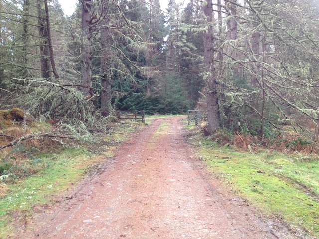
Inchnacardoch Forest is located in Inverness-shire, Scotland, covering an area of approximately 4,000 hectares. The forest is predominantly composed of native species such as Scots pine, birch, and oak, providing a diverse habitat for wildlife including red squirrels, deer, and a variety of bird species.

The forest is managed by Forestry and Land Scotland, with a focus on sustainable forestry practices and conservation efforts. Visitors to the forest can enjoy a network of walking and cycling trails, offering stunning views of the surrounding landscape and opportunities to spot wildlife.

Inchnacardoch Forest is also home to a number of archaeological sites, including ancient settlements and burial grounds, providing a glimpse into the area's rich history. The forest is popular with outdoor enthusiasts, offering a peaceful and scenic setting for activities such as hiking, birdwatching, and photography.

Overall, Inchnacardoch Forest is a valuable natural resource in the Inverness-shire area, providing both recreational opportunities for visitors and important habitat for a variety of plant and animal species.

If you have any feedback on the listing, please let us know in the comments section below.

Inchnacardoch Forest Images

Images are sourced within 2km of 57.136088/-4.7424441 or Grid Reference NH3408. Thanks to Geograph Open Source API. All images are credited.

Forest road, Auchteraw
New path, Auchteraw A path now follows the power line linking up with a new road further along. This makes a good circular walk with some fine views.
New path, Auchteraw
A path now follows the power line linking up with a new road further along. This makes a good circular walk with some fine views.
Road end There is a new road following the pylons. It is linked to the older road network by a well built path forming a loop.
Road end
There is a new road following the pylons. It is linked to the older road network by a well built path forming a loop.
Minor road at Auchteraw Looking westward.
The road on the left gives access to Fort Augustus electricity sub-station.
Minor road at Auchteraw
Looking westward. The road on the left gives access to Fort Augustus electricity sub-station.
Minor road at Achteraw House Looking south-westward.
Minor road at Achteraw House
Looking south-westward.
Minor road at Auchteraw Looking south-westward.
Minor road at Auchteraw
Looking south-westward.
Kytra lock on the Caledonian canal
Disused winding gear at Kytra Lock, Caledonian Canal
Caledonian Canal and River Oich near Kytra lock Excess water from the Caledonian Canal flows over the Great Glen Way to the River Oich on the left.
Caledonian Canal and River Oich near Kytra lock
Excess water from the Caledonian Canal flows over the Great Glen Way to the River Oich on the left.
Forestry road near Auchteraw
Track to picnic area near Auchteraw
Forestry road near Auchteraw
Forestry Track beside Allt na Feàrna
Ski Tracks below Pylons on Old Military Road The Forest road/ Old Military road approaching forest clearing where 2 lines of Pylons converge and go down to Fort Augustus.
Ski Tracks below Pylons on Old Military Road
The Forest road/ Old Military road approaching forest clearing where 2 lines of Pylons converge and go down to Fort Augustus.
Track Passing Pylons on Old Military Road
Glen Morrison Old Military Road
Show me another place!

Inchnacardoch Forest is located at Grid Ref: NH3408 (Lat: 57.136088, Lng: -4.7424441)

Unitary Authority: Highland

Police Authority: Highlands and Islands

What 3 Words

///rates.repelled.loving. Near Cannich, Highland

Nearby Locations

Inchnacardoch Forest

Related Wikis

Caledonian Canal

The Caledonian Canal connects the Scottish east coast at Inverness with the west coast at Corpach near Fort William in Scotland. The canal was constructed...

Scottish Highlands

The Highlands (Scots: the Hielands; Scottish Gaelic: a' Ghàidhealtachd [ə ˈɣɛːəl̪ˠt̪ʰəxk], "the place of the Gaels") is a historical region of Scotland...

Caledonian Forest

The Caledonian Forest is the ancient (old-growth) temperate forest of Scotland. The forest today is a reduced-extent version of the pre-human-settlement...

Fort Augustus railway station

Fort Augustus was a railway station in Inverness-shire, Scotland on the Invergarry and Fort Augustus Railway between 1903 and 1946. == Overview == The...

Nearby Amenities

Located within 500m of 57.136088,-4.7424441
Power: pole
Lat/Long: 57.1320968/-4.7426069
Power: pole
Lat/Long: 57.1324345/-4.7413999
Power: pole
Lat/Long: 57.1327897/-4.7401768
Power: pole
Lat/Long: 57.1331972/-4.7388089
Power: pole
Lat/Long: 57.1334942/-4.7376984
Power: pole
Lat/Long: 57.1340793/-4.7356868
The data included in this document is from www.openstreetmap.org. The data is made available under ODbL.

Have you been to Inchnacardoch Forest?

Leave your review of Inchnacardoch Forest below (or comments, questions and feedback).