Doire Dharaich

Wood, Forest in Ross-shire

Scotland

Doire Dharaich

The eastern side of Loch Allt an Daraich Cliffs drop straight into the waters of the loch. Ruadh-stac Mòr makes its presence felt in the distance.
The eastern side of Loch Allt an Daraich Credit: Nigel Brown

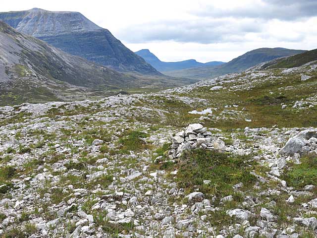
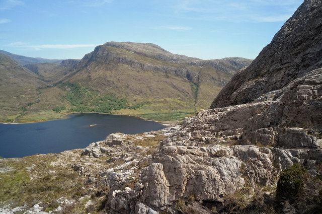
Doire Dharaich, located in Ross-shire, Scotland, is a picturesque woodland area known for its natural beauty and diverse flora and fauna. The name "Doire Dharaich" translates to "Wood, Forest" in Scottish Gaelic, which aptly describes the lush and dense vegetation that characterizes the area.

The woodland is spread over a vast expanse, offering visitors a tranquil and serene environment to explore and enjoy. The diverse range of trees, including oak, birch, and pine, creates a rich and vibrant tapestry of colors throughout the year. In spring, the forest comes alive with a burst of fresh greenery, while autumn brings a stunning display of vibrant reds, oranges, and yellows as the leaves change.

Doire Dharaich is home to a wide variety of wildlife, making it a popular destination for nature enthusiasts and birdwatchers. Visitors may spot red squirrels, roe deer, and a range of bird species, including woodpeckers, owls, and various songbirds. The forest is also home to a number of rare and protected species, adding to its ecological importance.

The woodland offers a network of well-maintained trails and paths, providing opportunities for hiking, walking, and cycling. There are also picnic areas and viewpoints dotted throughout the forest, allowing visitors to take in the breathtaking scenery and enjoy a peaceful day out in nature.

Overall, Doire Dharaich is a haven for those seeking solace in nature, offering a stunning and tranquil setting to explore the wonders of the Scottish woodlands.

If you have any feedback on the listing, please let us know in the comments section below.

Doire Dharaich Images

Images are sourced within 2km of 57.607351/-5.3429181 or Grid Reference NH0062. Thanks to Geograph Open Source API. All images are credited.

The eastern side of Loch Allt an Daraich Cliffs drop straight into the waters of the loch. Ruadh-stac Mòr makes its presence felt in the distance.
The eastern side of Loch Allt an Daraich
Cliffs drop straight into the waters of the loch. Ruadh-stac Mòr makes its presence felt in the distance.
Meall a' Ghiuthais Seen from the viewpoint on the Mountain Trail.
Meall a' Ghiuthais
Seen from the viewpoint on the Mountain Trail.
Quarzite slabs with perched boulders The mountain, Meall a' Ghiubhais has extensive exposures of rock on its upper slopes. The view is from the 'Mountain Trail' on the Beinn Eighe National Nature Reserve. The obvious snow-patched mountain is Fionn Bheinn.
Quarzite slabs with perched boulders
The mountain, Meall a' Ghiubhais has extensive exposures of rock on its upper slopes. The view is from the 'Mountain Trail' on the Beinn Eighe National Nature Reserve. The obvious snow-patched mountain is Fionn Bheinn.
Tree line The last sizeable Scots pine on this stretch of the mountain trail, at just over 300m. Loch Maree is below.
Tree line
The last sizeable Scots pine on this stretch of the mountain trail, at just over 300m. Loch Maree is below.
Upper parts of the mountain trail At a height of about 450m the trail is now on open hillside with patchy cover of heather on the quartzite rock. Across Loch Maree is Gleann Bianasdail which is one way in to the wilds of the Fisherfield Forest and its fine remote mountains.
Upper parts of the mountain trail
At a height of about 450m the trail is now on open hillside with patchy cover of heather on the quartzite rock. Across Loch Maree is Gleann Bianasdail which is one way in to the wilds of the Fisherfield Forest and its fine remote mountains.
Conservation cairn, mountain trail At 550m this is the highest point on the mountain trail and would be a good closer viewpoint for Beinn Eighe. However, the mist was showing no signs of lifting so we descended.
Conservation cairn, mountain trail
At 550m this is the highest point on the mountain trail and would be a good closer viewpoint for Beinn Eighe. However, the mist was showing no signs of lifting so we descended.
Col between Ruadh-stac Beag and Meall a'Ghiubhais The small cairn marks a faint path that crosses the stony and boggy ground
Col between Ruadh-stac Beag and Meall a'Ghiubhais
The small cairn marks a faint path that crosses the stony and boggy ground
Moorland path to Meall a'Ghuibhais A good path through the rocky and boggy ground
Moorland path to Meall a'Ghuibhais
A good path through the rocky and boggy ground
Drochaid Allt Toll a' Ghiubhais Top of a pony path running up from Kinlochewe.  A view of Beinn Eighe with Ruadh-stac Beag dominating.
Drochaid Allt Toll a' Ghiubhais
Top of a pony path running up from Kinlochewe. A view of Beinn Eighe with Ruadh-stac Beag dominating.
Cairns for marking the Mountain Trail Cairns abound in the steep section of the mountain trail.

The mountain trail is described in detail in <span class="nowrap"><a title="http://www.snh.org.uk/pdfs/publications/designatedareas/beinneighemounttrail.pdf" rel="nofollow ugc noopener" href="http://www.snh.org.uk/pdfs/publications/designatedareas/beinneighemounttrail.pdf">Link</a><img style="margin-left:2px;" alt="External link" title="External link - shift click to open in new window" src="https://s1.geograph.org.uk/img/external.png" width="10" height="10"/></span>
Cairns for marking the Mountain Trail
Cairns abound in the steep section of the mountain trail. The mountain trail is described in detail in LinkExternal link
Steep rock section of the Beinn Eighe Reserve Mountain Trail Cairns mark the way.

For more information on the Mountain Trail see <span class="nowrap"><a title="http://www.snh.org.uk/pdfs/publications/designatedareas/beinneighemounttrail.pdf" rel="nofollow ugc noopener" href="http://www.snh.org.uk/pdfs/publications/designatedareas/beinneighemounttrail.pdf">Link</a><img style="margin-left:2px;" alt="External link" title="External link - shift click to open in new window" src="https://s1.geograph.org.uk/img/external.png" width="10" height="10"/></span>
Steep rock section of the Beinn Eighe Reserve Mountain Trail
Cairns mark the way. For more information on the Mountain Trail see LinkExternal link
Way marker cairns on the Mountain Trail In the steep terrain, the cairns are reassuring. Loch Maree in the background.
Way marker cairns on the Mountain Trail
In the steep terrain, the cairns are reassuring. Loch Maree in the background.
East end of Loch Maree from the Mountain Trail And nearer at hand a steep path to gain height on the Mountain Trail.
East end of Loch Maree from the Mountain Trail
And nearer at hand a steep path to gain height on the Mountain Trail.
On the Beinn Eighe Reserve Mountain Trail Lone tree high up the trail.

For more information on the trail See <span class="nowrap"><a title="http://www.snh.org.uk/pdfs/publications/designatedareas/beinneighemounttrail.pdf" rel="nofollow ugc noopener" href="http://www.snh.org.uk/pdfs/publications/designatedareas/beinneighemounttrail.pdf">Link</a><img style="margin-left:2px;" alt="External link" title="External link - shift click to open in new window" src="https://s1.geograph.org.uk/img/external.png" width="10" height="10"/></span>
On the Beinn Eighe Reserve Mountain Trail
Lone tree high up the trail. For more information on the trail See LinkExternal link
Conservation Cairn and summit of Leathad Buidhe The high point of the Mountain Trail of the Beinn Eighe Reserve.  

The reason the cairn is called Conservation Cairn is a here.  <span class="nowrap"><a title="http://www.snh.org.uk/pdfs/publications/designatedareas/beinneighemounttrail.pdf" rel="nofollow ugc noopener" href="http://www.snh.org.uk/pdfs/publications/designatedareas/beinneighemounttrail.pdf">Link</a><img style="margin-left:2px;" alt="External link" title="External link - shift click to open in new window" src="https://s1.geograph.org.uk/img/external.png" width="10" height="10"/></span>
Conservation Cairn and summit of Leathad Buidhe
The high point of the Mountain Trail of the Beinn Eighe Reserve. The reason the cairn is called Conservation Cairn is a here. LinkExternal link
Loch Allt an Daraich from the summit of Leathad Buidhe The nearby Corbett is Meall a' Ghiubhais.  The line of the Mountain Trail is clearly visible.

The Mountain Trail is described here.  <span class="nowrap"><a title="http://www.snh.org.uk/pdfs/publications/designatedareas/beinneighemounttrail.pdf" rel="nofollow ugc noopener" href="http://www.snh.org.uk/pdfs/publications/designatedareas/beinneighemounttrail.pdf">Link</a><img style="margin-left:2px;" alt="External link" title="External link - shift click to open in new window" src="https://s1.geograph.org.uk/img/external.png" width="10" height="10"/></span>
Loch Allt an Daraich from the summit of Leathad Buidhe
The nearby Corbett is Meall a' Ghiubhais. The line of the Mountain Trail is clearly visible. The Mountain Trail is described here. LinkExternal link
Loch Allt an Daraich from the Mountain Trail Behind the loch lies Beinn Eighe and its outliers. A way marker for the Mountain Trail is visible.

For information on the Mountain Trail see <span class="nowrap"><a title="http://www.snh.org.uk/pdfs/publications/designatedareas/beinneighemounttrail.pdf" rel="nofollow ugc noopener" href="http://www.snh.org.uk/pdfs/publications/designatedareas/beinneighemounttrail.pdf">Link</a><img style="margin-left:2px;" alt="External link" title="External link - shift click to open in new window" src="https://s1.geograph.org.uk/img/external.png" width="10" height="10"/></span>.
Loch Allt an Daraich from the Mountain Trail
Behind the loch lies Beinn Eighe and its outliers. A way marker for the Mountain Trail is visible. For information on the Mountain Trail see LinkExternal link.
Unnamed lochan beside the Mountain Trail Some green adds to the brown palette by the lochan.
Unnamed lochan beside the Mountain Trail
Some green adds to the brown palette by the lochan.
Show me another place!

Doire Dharaich is located at Grid Ref: NH0062 (Lat: 57.607351, Lng: -5.3429181)

Unitary Authority: Highland

Police Authority: Highlands and Islands

What 3 Words

///segregate.walnuts.typed. Near Kinlochewe, Highland

Nearby Locations

Doire Dharaich

Related Wikis

Taagan

Taagan (Scottish Gaelic: Na Tathagan) is a hamlet in Ross and Cromarty, in the Highland council area of Scotland. It is situated about 2 km north west...

Anancaun

Anancaun (Scottish Gaelic: Àth nan Ceann) is a small hamlet located in Ross-shire, Scotland, within the Scottish council area of Highland. == References ==

Cape Wrath Trail

Cape Wrath Trail is a hiking route that runs through the Scottish Highlands and along the west coast of Scotland. It is approximately 200 miles (321 km...

Kinlochewe

Kinlochewe (Scottish Gaelic: Ceann Loch Iù or Iùbh) is a village in Wester Ross in the Northwest Highlands of Scotland. It is in the parish of Gairloch...

Have you been to Doire Dharaich?

Leave your review of Doire Dharaich below (or comments, questions and feedback).