Calvert

Settlement in Buckinghamshire

England

Calvert

Calvert waste depot and Greatmoor EFW incinerator Two months on from the previous picture with this title (6937388), all trackwork passing the remains of the old Calvert Station platforms has been removed in readiness for the continuation of HS2 works.  The waste terminal will be rebuilt to the left and HS2 tracks will pass through where the photographer is standing.
Calvert waste depot and Greatmoor EFW incinerator Credit: Bob Walters

Calvert is a small village located in the county of Buckinghamshire, England. Situated in the Aylesbury Vale district, it is approximately 5 miles southwest of Buckingham and 11 miles northwest of Aylesbury. The village is nestled in a rural area surrounded by picturesque countryside, offering residents and visitors a tranquil and scenic environment.

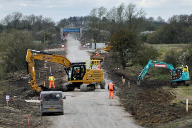
Calvert is primarily an agricultural community, with farming playing a significant role in the local economy. The land is predominantly used for arable farming, cultivating crops such as wheat, barley, and oilseed rape. The village also benefits from its proximity to the Calvert Landfill Site, which provides employment opportunities for the local population.

Despite its small size, Calvert has a rich history dating back to the medieval era. The village is home to several historic buildings and landmarks, including the Grade II listed St. Mary the Virgin Church, which dates back to the 13th century. The church features a beautiful timber-framed tower and is an important architectural and cultural heritage site.

While Calvert may be a quiet and peaceful village, it is well-connected to nearby towns and cities. The A421 road runs through the village, providing easy access to Buckingham, Aylesbury, and Milton Keynes. The village also benefits from a regular bus service, allowing residents to travel to surrounding areas conveniently.

Overall, Calvert is a charming and idyllic village that offers a slower pace of life and a close-knit community. Its beautiful countryside setting, rich history, and convenient location make it an attractive place to live or visit for those seeking a rural retreat in Buckinghamshire.

If you have any feedback on the listing, please let us know in the comments section below.

Calvert Images

Images are sourced within 2km of 51.915296/-1.002437 or Grid Reference SP6824. Thanks to Geograph Open Source API. All images are credited.

Calvert waste depot and Greatmoor EFW incinerator Two months on from the previous picture with this title (6937388), all trackwork passing the remains of the old Calvert Station platforms has been removed in readiness for the continuation of HS2 works.  The waste terminal will be rebuilt to the left and HS2 tracks will pass through where the photographer is standing.
Calvert waste depot and Greatmoor EFW incinerator
Two months on from the previous picture with this title (6937388), all trackwork passing the remains of the old Calvert Station platforms has been removed in readiness for the continuation of HS2 works. The waste terminal will be rebuilt to the left and HS2 tracks will pass through where the photographer is standing.
Portway Farm from GCR Bridge 558 A view south east from GCR Bridge No.558 showing the former Great Central Railway trackbed passing Portway Farm on the right.  The line was closed in 1966, but now the new HS2 railway is being built here, and will pass just to the left of this scene.
Portway Farm from GCR Bridge 558
A view south east from GCR Bridge No.558 showing the former Great Central Railway trackbed passing Portway Farm on the right. The line was closed in 1966, but now the new HS2 railway is being built here, and will pass just to the left of this scene.
Work on East West Railway Work being carried out near Charndon on the embankment and trackbed of the old Bicester to Bletchley line to ready it for the relaying of double track for the new East West Railway services between Milton Keynes and Oxford.  An overbridge for the Charndon to Poundon bridleway is in the distance.
Work on East West Railway
Work being carried out near Charndon on the embankment and trackbed of the old Bicester to Bletchley line to ready it for the relaying of double track for the new East West Railway services between Milton Keynes and Oxford. An overbridge for the Charndon to Poundon bridleway is in the distance.
Where HS2 and East West Railway will cross A view from the road bridge of progress at the crossing of HS2 and East West Railway (EWR).  The piers of the bridge over HS2 have been built; this will run left to right at the bottom of the picture.  EWR will cross this bridge from top to bottom of the picture.  The road bridge that the photographer is standing on will be replaced by a new bridge under the EWR tracks.  In the distance can be seen Addison Road bridge and beyond that the new bridge to take Queen Catherine Road; this replaces a level crossing at the site of the former Claydon Station.
Where HS2 and East West Railway will cross
A view from the road bridge of progress at the crossing of HS2 and East West Railway (EWR). The piers of the bridge over HS2 have been built; this will run left to right at the bottom of the picture. EWR will cross this bridge from top to bottom of the picture. The road bridge that the photographer is standing on will be replaced by a new bridge under the EWR tracks. In the distance can be seen Addison Road bridge and beyond that the new bridge to take Queen Catherine Road; this replaces a level crossing at the site of the former Claydon Station.
Dust and tipper trucks A continuous procession of tipper trucks carrying stone for the HS2 and EWR works at the site of the old Calvert GCR Station.  HS2 is due to pass through here and the new EWR tracks will cross over it just north of here.
Dust and tipper trucks
A continuous procession of tipper trucks carrying stone for the HS2 and EWR works at the site of the old Calvert GCR Station. HS2 is due to pass through here and the new EWR tracks will cross over it just north of here.
HS2 worksite This view is from Addison Road east towards the HS2/East West Railway work site.  This area will become part of the Infrastructure Maintenance Depot for HS2.  It lies along the route of the East West Railway line, which crosses the path of HS2 at Calvert.  This part of EWR is being constructed as part of the HS2 works in the area.  When complete, the depot will be connected to both HS2 and EWR, enabling access from all directions.
HS2 worksite
This view is from Addison Road east towards the HS2/East West Railway work site. This area will become part of the Infrastructure Maintenance Depot for HS2. It lies along the route of the East West Railway line, which crosses the path of HS2 at Calvert. This part of EWR is being constructed as part of the HS2 works in the area. When complete, the depot will be connected to both HS2 and EWR, enabling access from all directions.
Where the bridge once stood The bridge over the railway line on Addison Road has been demolished recently and the whole area flattened.  This view is westwards towards Calvert.  At the moment, the road is level at this point, but a new bridge is being constructed on its eastern side to take the road over the new East West Railway tracks and those of the HS2 Infrastructure Maintenance Depot which is being built here.
Where the bridge once stood
The bridge over the railway line on Addison Road has been demolished recently and the whole area flattened. This view is westwards towards Calvert. At the moment, the road is level at this point, but a new bridge is being constructed on its eastern side to take the road over the new East West Railway tracks and those of the HS2 Infrastructure Maintenance Depot which is being built here.
New bridge for Addison Road Addison Road (foreground) will have a new bridge across the East West Railway and the HS2 Infrastructure Maintenance Depot sidings.  The old bridge has been demolished and Addison Road is at present on the level through the site.  The new bridge will span about eight railway tracks when complete.
New bridge for Addison Road
Addison Road (foreground) will have a new bridge across the East West Railway and the HS2 Infrastructure Maintenance Depot sidings. The old bridge has been demolished and Addison Road is at present on the level through the site. The new bridge will span about eight railway tracks when complete.
Ramp up to bridge OXD/29, 2014 Charndon Main Street crosses the former Oxford - Bletchley line.
Ramp up to bridge OXD/29, 2014
Charndon Main Street crosses the former Oxford - Bletchley line.
Former Oxford - Bletchley line, 2014 Before upgrading to passenger standards. Looking towards Bicester.
Former Oxford - Bletchley line, 2014
Before upgrading to passenger standards. Looking towards Bicester.
Footpath parallel with railway, 2014 Now closed during railway upgrading work, and the trees cut back.
Footpath parallel with railway, 2014
Now closed during railway upgrading work, and the trees cut back.
A road called School Hill From Charndon to Calvert.
A road called School Hill
From Charndon to Calvert.
Railway east of bridge OXD/28, 2014 The Oxford - Bletchley line, which was partly disused, but not here. In the distance is the junction for a spur onto what remained of the old Great Central line. The lines here survived for the use of landfill trains.
Railway east of bridge OXD/28, 2014
The Oxford - Bletchley line, which was partly disused, but not here. In the distance is the junction for a spur onto what remained of the old Great Central line. The lines here survived for the use of landfill trains.
Railway west of bridge OXD/28, 2014 The Oxford - Bletchley line, which was partly disused, but not here.
Railway west of bridge OXD/28, 2014
The Oxford - Bletchley line, which was partly disused, but not here.
New bridge under construction A new bridge under construction to take the Bletchley to Bicester railway line over the road rather than under it.  The railway line is being raised here so that the new HS2 railway can pass beneath it.  The bridge that the photographer is standing on will be demolished and the road diverted beneath the new bridge.  Beyond is the trackbed of the Bletchley line being raised to cross the new bridge.
New bridge under construction
A new bridge under construction to take the Bletchley to Bicester railway line over the road rather than under it. The railway line is being raised here so that the new HS2 railway can pass beneath it. The bridge that the photographer is standing on will be demolished and the road diverted beneath the new bridge. Beyond is the trackbed of the Bletchley line being raised to cross the new bridge.
Crossroads near Calvert
Track to barn near Charndon
Remains of Calvert station, 1984 View SE, towards Grendon Underwood Junction, Quainton Road, Aylesbury and London Marylebone: ex-GC Marylebone - Sheffield main line. The station was closed 4/3/63 (goods, 4/5/64), the main line from 5/9/66. A loop from Claydon on the ex-LNW Bletchley - Oxford line, opened 14/9/40 as a wartime connection, remained until 22/11/65. The tracks visible here serve primarily the large Waste Depot (former quarry) and come from Aylesbury via Quainton Road.
Remains of Calvert station, 1984
View SE, towards Grendon Underwood Junction, Quainton Road, Aylesbury and London Marylebone: ex-GC Marylebone - Sheffield main line. The station was closed 4/3/63 (goods, 4/5/64), the main line from 5/9/66. A loop from Claydon on the ex-LNW Bletchley - Oxford line, opened 14/9/40 as a wartime connection, remained until 22/11/65. The tracks visible here serve primarily the large Waste Depot (former quarry) and come from Aylesbury via Quainton Road.
Show me another place!

Calvert is located at Grid Ref: SP6824 (Lat: 51.915296, Lng: -1.002437)

Unitary Authority: Buckinghamshire

Police Authority: Thames Valley

What 3 Words

///circling.snaps.pats. Near Steeple Claydon, Buckinghamshire

Nearby Locations

Calvert

Related Wikis

Calvert, Buckinghamshire

Calvert is a village in Buckinghamshire, England, near the village of Steeple Claydon. Originally named after a wealthy local family who had inherited...

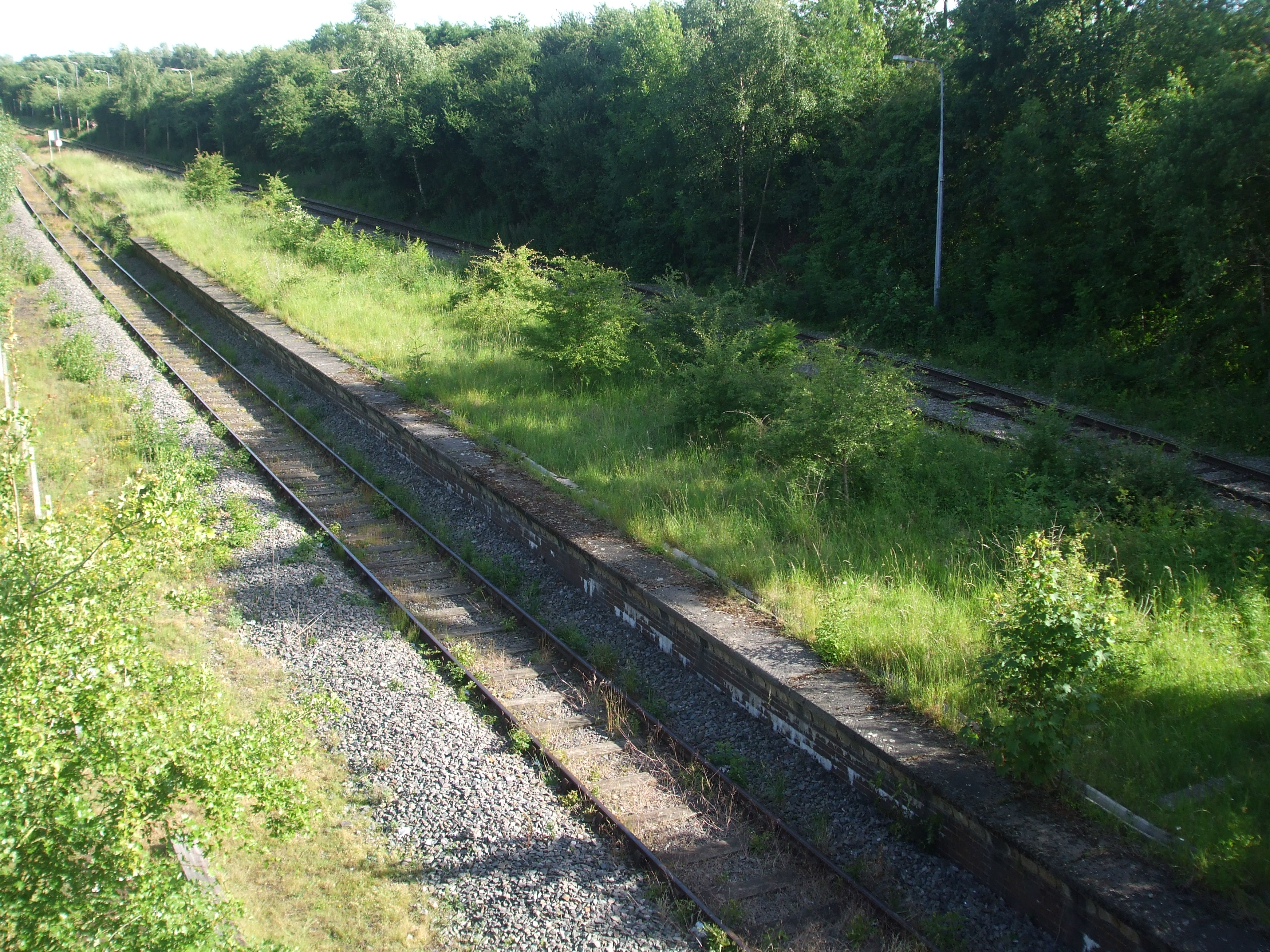
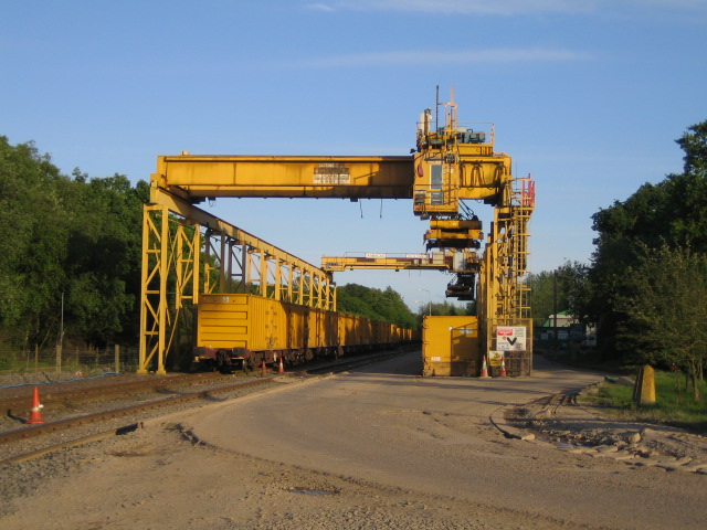
Calvert railway station

Calvert was a railway station at Calvert, Buckinghamshire on the former Great Central Main Line between Manchester Piccadilly and London Marylebone. The...

Calvert Green

Calvert Green is a civil parish in Aylesbury Vale, Buckinghamshire, England. It was created in 2003 from parts of Charndon and Steeple Claydon civil parishes...
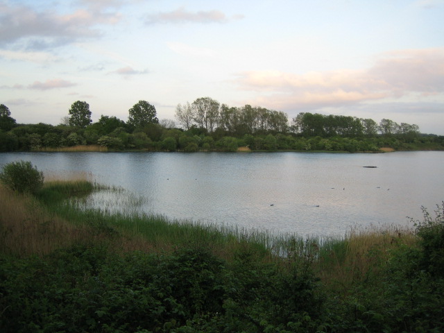
Calvert Jubilee

Calvert Jubilee is a 22 hectares (54 acres) nature reserve in Calvert near Steeple Claydon in Buckinghamshire. It is managed by the Berkshire, Buckinghamshire...

Nearby Amenities

Located within 500m of 51.915296,-1.002437
Calvert
Is In Country: GB
Is In State: Buckinghamshire
Place: village
Wikidata: Q1860052
Wikipedia: en:Calvert, Buckinghamshire
Lat/Long: 51.9158024/-1.0013525
Post Box
Ref: MK18 64
Lat/Long: 51.9163181/-1.0020511
Traffic Calming: table
Lat/Long: 51.9120588/-1.0023502
Traffic Calming: table
Lat/Long: 51.9117518/-1.003466
Traffic Calming: table
Lat/Long: 51.9109533/-1.0041828
Traffic Calming: table
Lat/Long: 51.912058/-1.0040302
Post Box
Ref: MK18 537
Lat/Long: 51.9111616/-1.0038729
Railway: switch
Lat/Long: 51.9169054/-1.0007422
Railway: switch
Lat/Long: 51.9172759/-1.0011342
Calvert North Ground Frame
Railway: site
Ref Tiploc: CALVNGF
Lat/Long: 51.917777/-1.0015057
Calvert Green
Place: village
Lat/Long: 51.9122371/-1.0027962
Direction: forward
Traffic Calming: table
Lat/Long: 51.9131638/-0.9994235
Direction: backward
Traffic Calming: table
Lat/Long: 51.9129266/-0.9993908
Direction: backward
Traffic Calming: table
Lat/Long: 51.9124085/-0.9992044
Railway: switch
Lat/Long: 51.9138208/-0.9973919
Railway: switch
Lat/Long: 51.914167/-0.9976638
Power: pole
Lat/Long: 51.9147802/-0.999788
Power: pole
Lat/Long: 51.9149341/-0.9987715
Power: pole
Lat/Long: 51.9151194/-0.9980902
Power: pole
Lat/Long: 51.9157349/-0.9971595
Power: pole
Lat/Long: 51.9163305/-0.9962636
Traffic Calming: table
Lat/Long: 51.9119753/-1.0051602
Power: pole
Lat/Long: 51.9188102/-0.9983456
Power: pole
Lat/Long: 51.9179634/-0.998454
Power: pole
Lat/Long: 51.9169114/-0.998597
Power: pole
Lat/Long: 51.9164188/-0.998666
Power: pole
Lat/Long: 51.9158806/-0.9987498
Power: pole
Lat/Long: 51.9153774/-0.9992724
Calvert
Historic Railway: station
Railway: site
Wikidata: Q5024286
Lat/Long: 51.9165626/-1.000243
Direction: 230
Generator Method: photovoltaic
Generator Output Electricity: yes
Generator Solar Modules: 14
Generator Source: solar
Generator Type: solar_photovoltaic_panel
Location: roof
Power: generator
Lat/Long: 51.914017/-1.0006637
Direction: 165
Generator Method: photovoltaic
Generator Output Electricity: yes
Generator Solar Modules: 19
Generator Source: solar
Generator Type: solar_photovoltaic_panel
Location: roof
Power: generator
Lat/Long: 51.9136773/-1.0009341
Direction: forward
Traffic Calming: table
Lat/Long: 51.9125969/-0.9987628
Direction: forward
Traffic Calming: table
Lat/Long: 51.9121431/-0.9994561
Direction: 130
Generator Method: photovoltaic
Generator Output Electricity: yes
Generator Solar Modules: 10
Generator Source: solar
Generator Type: solar_photovoltaic_panel
Location: roof
Power: generator
Lat/Long: 51.9122074/-1.0035597
Direction: 310
Generator Method: photovoltaic
Generator Output Electricity: yes
Generator Solar Modules: 6
Generator Source: solar
Generator Type: solar_photovoltaic_panel
Location: roof
Power: generator
Lat/Long: 51.9122225/-1.0035942
Direction: 130
Generator Method: photovoltaic
Generator Output Electricity: yes
Generator Solar Modules: 10
Generator Source: solar
Generator Type: solar_photovoltaic_panel
Location: roof
Power: generator
Lat/Long: 51.9119822/-1.0033523
Direction: 220
Generator Method: photovoltaic
Generator Output Electricity: yes
Generator Solar Modules: 14
Generator Source: solar
Generator Type: solar_photovoltaic_panel
Location: roof
Power: generator
Lat/Long: 51.9123906/-1.0049223
Traffic Calming: table
Lat/Long: 51.9124566/-1.0044886
Direction: 210
Generator Method: photovoltaic
Generator Output Electricity: yes
Generator Solar Modules: 14
Generator Source: solar
Generator Type: solar_photovoltaic_panel
Location: roof
Power: generator
Lat/Long: 51.9129157/-1.003579
Information: guidepost
Tourism: information
Lat/Long: 51.9183592/-0.9972632
Railway: switch
Lat/Long: 51.9176324/-1.0003419
Railway: switch
Lat/Long: 51.9171047/-0.9997344
Railway: switch
Lat/Long: 51.9168235/-0.9994501
Mace
Brand: Mace
Brand Wikidata: Q75240338
Operator: Mace (UK)
Shop: convenience
Lat/Long: 51.911919/-1.0001136
Bus Stop
Brackley Lane
Bus: yes
Public Transport: platform
Shelter: no
Lat/Long: 51.9159913/-1.001268
Bus Stop
Brackley Lane
Bus: yes
Public Transport: platform
Shelter: no
Lat/Long: 51.9162278/-1.0012305
The data included in this document is from www.openstreetmap.org. The data is made available under ODbL.

Have you been to Calvert?

Leave your review of Calvert below (or comments, questions and feedback).