Callaly

Settlement in Northumberland

England

Callaly

Storm Arwen at Castle Hill Although the storm has rendered the usual path to Castle Hill impassable there are other possible routes to this natural 'play area' which, given its exposure, has escaped with a surprisingly small amount of damage.
Storm Arwen at Castle Hill Credit: Leanmeanmo

Callaly is a small village located in the county of Northumberland, England. Situated approximately 9 miles northwest of the town of Alnwick, Callaly is surrounded by picturesque countryside and is part of the Northumberland National Park.

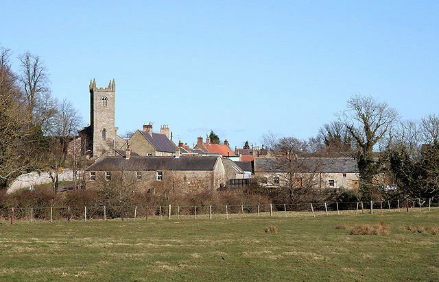
The village is known for its tranquil and rural setting, making it a popular destination for those seeking a peaceful retreat or a base for exploring the nearby natural beauty. Callaly is nestled within the Coquet Valley, which offers stunning views of rolling hills, lush green fields, and the meandering River Coquet.

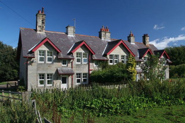
Historically, Callaly has been an agricultural community, with farming playing a significant role in the local economy. The village is characterized by a collection of traditional stone-built houses and cottages, giving it a charming and traditional English village feel.

One of the notable landmarks in Callaly is Callaly Castle, a Grade II* listed building dating back to the 16th century. This historic castle, with its imposing architecture and beautiful surroundings, adds to the village's appeal and attracts visitors interested in exploring its rich history.

For outdoor enthusiasts, Callaly offers plenty of opportunities for walking, hiking, and cycling. The nearby Northumberland National Park provides ample trails and routes for exploring the stunning landscapes and discovering the diverse flora and fauna of the region.

In summary, Callaly is a picturesque village in Northumberland, offering a peaceful retreat and access to the natural beauty of the surrounding countryside. With its historic castle, traditional architecture, and scenic location, it is a charming destination for those seeking a taste of rural England.

If you have any feedback on the listing, please let us know in the comments section below.

Callaly Images

Images are sourced within 2km of 55.379409/-1.918547 or Grid Reference NU0509. Thanks to Geograph Open Source API. All images are credited.

Storm Arwen at Castle Hill Although the storm has rendered the usual path to Castle Hill impassable there are other possible routes to this natural 'play area' which, given its exposure, has escaped with a surprisingly small amount of damage.
Storm Arwen at Castle Hill
Although the storm has rendered the usual path to Castle Hill impassable there are other possible routes to this natural 'play area' which, given its exposure, has escaped with a surprisingly small amount of damage.
Storm Arwen at Castle Hill Although the storm has rendered the usual path to Castle Hill impassable (left of picture) there are other possible routes to this natural 'play area' which, given its exposure, has escaped with a surprisingly small amount of damage.
Storm Arwen at Castle Hill
Although the storm has rendered the usual path to Castle Hill impassable (left of picture) there are other possible routes to this natural 'play area' which, given its exposure, has escaped with a surprisingly small amount of damage.
Storm Arwen at Callaly Woods Callaly Woods lost numerous trees to Storm Arwen on the 26th November 2021, leaving blocked tracks everywhere.  The estate has responded swiftly to clear the blocked paths and make the woods accessible again.
Storm Arwen at Callaly Woods
Callaly Woods lost numerous trees to Storm Arwen on the 26th November 2021, leaving blocked tracks everywhere. The estate has responded swiftly to clear the blocked paths and make the woods accessible again.
Callaly Castle Sometimes open to the public.
Callaly Castle
Sometimes open to the public.
Attractive avenue of trees in the late afternoon sun Castle Hill and Plantation off to the right.
Attractive avenue of trees in the late afternoon sun
Castle Hill and Plantation off to the right.
Mown field, Callaly Appears to be more of a garden extension than agricultural.
Mown field, Callaly
Appears to be more of a garden extension than agricultural.
Woodland, Callaly
Woodland, Callaly
Road, Callaly Running through a stripwood west of the castle.
Road, Callaly
Running through a stripwood west of the castle.
Young trees, Callaly A field recently planted with trees.
Young trees, Callaly
A field recently planted with trees.
Green lane, Yetlington
Callaly to Yetlington road
Stubble near High Houses Spring barley is still a crop here, good to see some Winter stubble.
Stubble near High Houses
Spring barley is still a crop here, good to see some Winter stubble.
Storm Arwen at Callaly Woods Callaly Woods lost numerous trees, hardwoods and conifers, to Storm Arwen on the 26th November 2021, leaving blocked tracks everywhere.  The estate has responded swiftly to clear the blocked paths and make the woods accessible again.  Some large trees, as in this case, one can simply walk around.
Storm Arwen at Callaly Woods
Callaly Woods lost numerous trees, hardwoods and conifers, to Storm Arwen on the 26th November 2021, leaving blocked tracks everywhere. The estate has responded swiftly to clear the blocked paths and make the woods accessible again. Some large trees, as in this case, one can simply walk around.
Callaly Woods
Callaly Woods
Telephone box, Callaly Next to the ruins of a telephone exchange.
Telephone box, Callaly
Next to the ruins of a telephone exchange.
Iron fingerpost, Callaly Behind the signpost a lot of Cabin Wood has been felled.
Iron fingerpost, Callaly
Behind the signpost a lot of Cabin Wood has been felled.
Cabin Wood Recently felled.
Cabin Wood
Recently felled.
Tram lines Tractor tracks in winter cereals near Whittingham.
Tram lines
Tractor tracks in winter cereals near Whittingham.
Show me another place!

Callaly is located at Grid Ref: NU0509 (Lat: 55.379409, Lng: -1.918547)

Unitary Authority: Northumberland

Police Authority: Northumbria

What 3 Words

///lotteries.spark.sheep. Near Whittingham, Northumberland

Related Wikis

Callaly

Callaly is a village and civil parish in Northumberland, England. It is about 9 miles (14 km) to the west of Alnwick. The main A697 road (to Morpeth) is...

Callaly Castle

Callaly Castle is a Grade I listed building and a substantial country house to the north of the village of Callaly, which is some 14.5 km (9.0 mi) to the...

Whittingham, Northumberland

Whittingham is a village and civil parish in Northumberland, England. It is situated on the banks of the River Aln, roughly 4.5 miles (7 km) east of its...

Yetlington

Yetlington is a village in the civil parish of Callaly, in the county of Northumberland, England. Yetlington seems to have been known in the Middle Ages...

Long Crag

Long Crag is a hill to the north of Rothbury in Northumberland, England. It lies within the Thrunton Woods, a Forestry Commission-owned area of forestry...

Eslington Park

Eslington Park is a privately owned 18th-century mansion house west of Whittingham, Northumberland, near the River Aln. It is the family seat of Lord...

Thrunton Wood

Thrunton Wood is an area of woodland and open moor in Northumberland. It is popular with walkers, mountain bikers and horse riders, and home to two waymarked...

Unthank, Alnham

Unthank is a hamlet and former civil parish, now in the parish of Alnham in Northumberland, England. In 1951 the parish had a population of 11. == History... ==

Nearby Amenities

Located within 500m of 55.379409,-1.918547
Callaly
Place: hamlet
Wikidata: Q3507854
Lat/Long: 55.3791064/-1.9165251
Post Box
Ref: NE66 105
Lat/Long: 55.3795816/-1.9188997
Barrier: stile
Lat/Long: 55.3757191/-1.9189298
The data included in this document is from www.openstreetmap.org. The data is made available under ODbL.

Have you been to Callaly?

Leave your review of Callaly below (or comments, questions and feedback).