Almholme

Settlement in Yorkshire

England

Almholme

Two Roads and a Railway The road to the left climbs over the railway, the one on the right leads to the railway for maintenance.
Two Roads and a Railway Credit: Michael Patterson

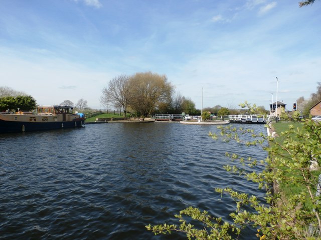
Almholme is a quaint village located in the county of Yorkshire, England. Situated on the banks of the River Don, it is nestled amidst lush green countryside, providing a picturesque backdrop for residents and visitors alike. With a population of around 1,000 people, Almholme maintains a close-knit community atmosphere.

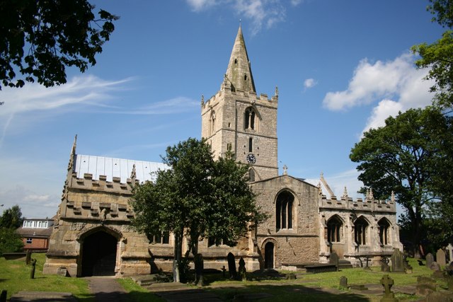
The village boasts a rich history, dating back to the medieval era when it was first mentioned in historical records. The presence of several well-preserved historic buildings adds to the charm and character of Almholme. The parish church of St. John the Baptist, a prominent feature in the village, is a stunning example of Gothic architecture and attracts tourists interested in its intricate design and stained glass windows.

Almholme offers a range of amenities to cater to the needs of its residents. The village has a primary school, a village hall, and a local pub, which serves as a social hub for both locals and visitors. The surrounding countryside is ideal for outdoor enthusiasts, with numerous walking and cycling trails crisscrossing the area.

The village is well-connected to the wider region by road, with easy access to nearby towns and cities. The bustling market town of Doncaster is just a short drive away, providing residents with a wider range of shopping and entertainment options.

Overall, Almholme embodies the charm and tranquility of a traditional English village, making it a sought-after destination for those seeking a peaceful and idyllic lifestyle.

If you have any feedback on the listing, please let us know in the comments section below.

Almholme Images

Images are sourced within 2km of 53.567537/-1.109845 or Grid Reference SE5908. Thanks to Geograph Open Source API. All images are credited.

Two Roads and a Railway The road to the left climbs over the railway, the one on the right leads to the railway for maintenance.
Two Roads and a Railway
The road to the left climbs over the railway, the one on the right leads to the railway for maintenance.
Private Level Crossing This level crossing leads to a glass works just behind the gate to the left.
Private Level Crossing
This level crossing leads to a glass works just behind the gate to the left.
Marsh Lane, Thorpe Marsh This is a private road, leading to the now defunct Thorpe marsh Power Station.
Marsh Lane, Thorpe Marsh
This is a private road, leading to the now defunct Thorpe marsh Power Station.
Missing letters! I wonder what the danger is?
Missing letters!
I wonder what the danger is?
Misty sunrise
Misty sunrise
Entrance to the disused Thorpe Marsh power station Off Fordstead Lane.
Entrance to the disused Thorpe Marsh power station
Off Fordstead Lane.
Marsh Lane
Marsh Lane
Tracks along the embankment.
St Oswalds This odd little church is found beside the canal.
St Oswalds
This odd little church is found beside the canal.
Long Sandall lock Set amongst industrial estates and rough ground.
Long Sandall lock
Set amongst industrial estates and rough ground.
St Oswald's Church in Kirk Sandall Church dedicated to Saint Oswald, king of Northumbria, whose body may have been rested here following his death in 642. The church was declared redundant in 1979 but is maintained and held in Trust.
St Oswald's Church in Kirk Sandall
Church dedicated to Saint Oswald, king of Northumbria, whose body may have been rested here following his death in 642. The church was declared redundant in 1979 but is maintained and held in Trust.
Impressive almost complete timber framed pipe bridge
The unrideable RUPP (and it got worse) The path was muddy and strewn with rubble whole house bricks etc.
The unrideable RUPP (and it got worse)
The path was muddy and strewn with rubble whole house bricks etc.
Track and Road Intersection near Thorpe Marsh Power Station Track crossing Fortstead Lane en route to the disused plant.
Track and Road Intersection near Thorpe Marsh Power Station
Track crossing Fortstead Lane en route to the disused plant.
Don Navigation and Long Sandall Lock Wheatley Cut of the Dun (Don) Navigation pictured from a slightly precarious position at the water's edge. The lock can be seen on the right where it forms an approximate benchmark for the Normal Tidal Limit (NTL).
Don Navigation and Long Sandall Lock
Wheatley Cut of the Dun (Don) Navigation pictured from a slightly precarious position at the water's edge. The lock can be seen on the right where it forms an approximate benchmark for the Normal Tidal Limit (NTL).
Railway and Industrial Estate at Long Sandall Railway line between Kirk Sandall and Doncaster pictured from a road bridge (DOW/9) on Clay Lane. Beyond the industrial units is the flat landscape of Arksey Common.
Railway and Industrial Estate at Long Sandall
Railway line between Kirk Sandall and Doncaster pictured from a road bridge (DOW/9) on Clay Lane. Beyond the industrial units is the flat landscape of Arksey Common.
Marsh Lane towards Wait House Farm
Marsh Lane at Grumble Hurst Bridge My Ordnance Survey map shows this lane as a public right of way so we ignored the no trespassing sign.
Marsh Lane at Grumble Hurst Bridge
My Ordnance Survey map shows this lane as a public right of way so we ignored the no trespassing sign.
Show me another place!

Almholme is located at Grid Ref: SE5908 (Lat: 53.567537, Lng: -1.109845)

Division: West Riding

Unitary Authority: Doncaster

Police Authority: South Yorkshire

What 3 Words

///bossy.normal.dirt. Near Kirk Sandall, South Yorkshire

Nearby Locations

Almholme

Related Wikis

Almholme

Almholme is a hamlet in South Yorkshire, England. It was in the parish of Arksey, and is now in Bentley with Arksey unparished area. The term 'holme' relates...

Thorpe Marsh Nature Reserve

Thorpe Marsh Nature Reserve is a 77-hectare (190-acre) nature reserve located south-west of Thorpe in Balne, north of Doncaster in South Yorkshire, England...

Shaftholme

Shaftholme is a small hamlet in South Yorkshire, England, in the parish of Arksey that is located half a mile north of Bentley and two miles north of Doncaster...

Arksey

Arksey is a village in the City of Doncaster in South Yorkshire, England. It had an estimated population of 1,303 as of 2010. It was the birthplace of...

Sandall railway station

Sandall railway station served the suburb of Kirk Sandall, South Yorkshire, England, from 1857 to 1859 on the Doncaster to Thorne section of the South...

St Oswald's Church, Kirk Sandall

St Oswald's Church is a redundant Anglican church in Kirk Sandall, near Doncaster, South Yorkshire, England. It is recorded in the National Heritage List...

Bentley Colliery

Bentley Colliery was a coal mine in Bentley, near Doncaster in South Yorkshire, England, that operated between 1906 and 1993. In common with many other...

Tilts

Tilts is a hamlet in the City of Doncaster, South Yorkshire, England, some 4 miles (6.4 km) north of Doncaster city centre and 3 miles (4.8 km) south of...

Nearby Amenities

Located within 500m of 53.567537,-1.109845
Power: pole
Lat/Long: 53.5651351/-1.1042307
Power: pole
Lat/Long: 53.5664462/-1.1039951
Power: pole
Lat/Long: 53.5677842/-1.1037164
Power: pole
Lat/Long: 53.5690552/-1.1036425
The data included in this document is from www.openstreetmap.org. The data is made available under ODbL.

Have you been to Almholme?

Leave your review of Almholme below (or comments, questions and feedback).