Big Wood

Wood, Forest in Radnorshire

Wales

Big Wood

Part of Bryn Glas hill above Pilleth It was here, almost certainly, that in late June 1402 a force of Welsh men loyal to Owain Glyndwr must have camped, prior to the Battle of Bryn Glas or Battle of Pilleth.

The hill is a perfect medieval defensible site, domed with good all round views, with a water supply at a well or spring at Pilleth church and large enough to temporarily house several hundred men, some horses, baggage train and camp followers.

It commands the valley of the River Lugg, where a larger English army would have to come. If the English army was too large to be taken on the Welsh would have several escape routes deeper into Wales and across into neighbouring valleys. If battle brought victory then the English border town of Leominster or numerous manor houses and churches down the valley would be within striking distance of men with their blood up.
Part of Bryn Glas hill above Pilleth Credit: Jeremy Bolwell

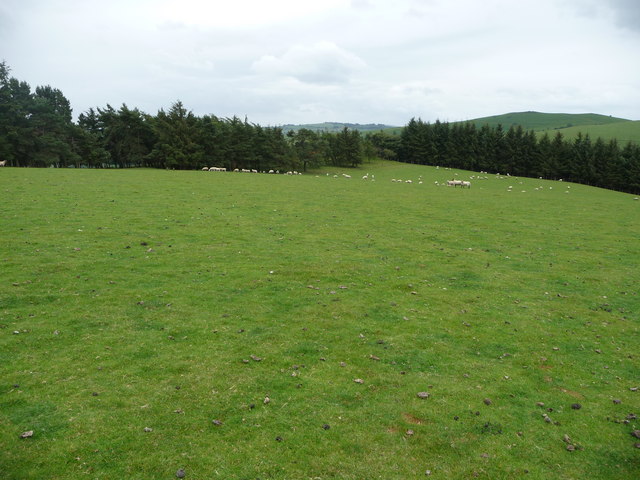
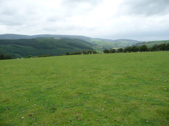
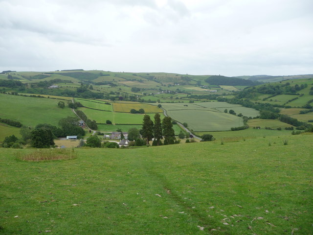
Big Wood is a dense forest located in the county of Radnorshire, Wales. Spanning across a vast area of approximately 500 acres, this woodland is renowned for its rich biodiversity and picturesque landscapes. It is situated near the village of New Radnor, surrounded by rolling hills and meandering streams.

The forest is predominantly composed of broadleaf trees, including oak, beech, and birch, which create a lush and vibrant canopy during the summer months. These trees provide shelter and food for a diverse range of wildlife, making Big Wood a haven for nature enthusiasts and birdwatchers.

Visitors to Big Wood can explore the forest through several well-maintained walking trails, allowing them to immerse themselves in the tranquility of nature. The trails wind through the forest, offering glimpses of enchanting wildflowers, fern-covered forest floors, and occasional sightings of deer and foxes.

Beyond the natural beauty, Big Wood also holds historical significance. The forest has remnants of ancient settlements, including burial mounds and stone circles, dating back to the Bronze Age. These archaeological sites provide a glimpse into the rich human history of the area.

Big Wood is not only a haven for wildlife and a place of historical importance but also serves as a recreational space for locals and tourists alike. Whether it is a leisurely walk, a picnic, or simply enjoying the serenity of nature, this woodland offers an escape from the hustle and bustle of daily life.

If you have any feedback on the listing, please let us know in the comments section below.

Big Wood Images

Images are sourced within 2km of 52.322096/-3.110718 or Grid Reference SO2469. Thanks to Geograph Open Source API. All images are credited.

Part of Bryn Glas hill above Pilleth It was here, almost certainly, that in late June 1402 a force of Welsh men loyal to Owain Glyndwr must have camped, prior to the Battle of Bryn Glas or Battle of Pilleth.

The hill is a perfect medieval defensible site, domed with good all round views, with a water supply at a well or spring at Pilleth church and large enough to temporarily house several hundred men, some horses, baggage train and camp followers.

It commands the valley of the River Lugg, where a larger English army would have to come. If the English army was too large to be taken on the Welsh would have several escape routes deeper into Wales and across into neighbouring valleys. If battle brought victory then the English border town of Leominster or numerous manor houses and churches down the valley would be within striking distance of men with their blood up.
Part of Bryn Glas hill above Pilleth
It was here, almost certainly, that in late June 1402 a force of Welsh men loyal to Owain Glyndwr must have camped, prior to the Battle of Bryn Glas or Battle of Pilleth. The hill is a perfect medieval defensible site, domed with good all round views, with a water supply at a well or spring at Pilleth church and large enough to temporarily house several hundred men, some horses, baggage train and camp followers. It commands the valley of the River Lugg, where a larger English army would have to come. If the English army was too large to be taken on the Welsh would have several escape routes deeper into Wales and across into neighbouring valleys. If battle brought victory then the English border town of Leominster or numerous manor houses and churches down the valley would be within striking distance of men with their blood up.
Part of Bryn Glas hill near Pilleth, looking north west Looking into Wales the hills get a little higher and more steep, imposing and impressive. It was here that a Welsh army loyal to Owain Glyndwr camped on the night of 21st June 1402 prior to what has become known as the Battle of Bryn Glas or Battle of Pilleth, a resounding Welsh victory just under two years into the revolt against usurper English king, Henry Bolingbroke, King Henry IV.

Of course the Welsh force didn't know that they would be victors that night but they must have hoped for it, based on intelligence that the county levy of Herefordshire was a day or so march down the valley. This was no massive English army of professional knights, time served noblemen, seasoned soldiers or men-at-arms but a force comprising farmers, their sons, yeomen and tavern braggards. It was led by Edmund Mortimer and dotted with Herefordshire landowners and their retinues. It also comprised Welsh archers, in service to English lords but possibly already in league with Glyndwr's men and ready to turn on their appointed lords at the precise time instructed.
Part of Bryn Glas hill near Pilleth, looking north west
Looking into Wales the hills get a little higher and more steep, imposing and impressive. It was here that a Welsh army loyal to Owain Glyndwr camped on the night of 21st June 1402 prior to what has become known as the Battle of Bryn Glas or Battle of Pilleth, a resounding Welsh victory just under two years into the revolt against usurper English king, Henry Bolingbroke, King Henry IV. Of course the Welsh force didn't know that they would be victors that night but they must have hoped for it, based on intelligence that the county levy of Herefordshire was a day or so march down the valley. This was no massive English army of professional knights, time served noblemen, seasoned soldiers or men-at-arms but a force comprising farmers, their sons, yeomen and tavern braggards. It was led by Edmund Mortimer and dotted with Herefordshire landowners and their retinues. It also comprised Welsh archers, in service to English lords but possibly already in league with Glyndwr's men and ready to turn on their appointed lords at the precise time instructed.
The site of the Battle of Brynglas / Pilleth Where the Welsh force must have stood before the battle, watching the English force approach up the valley of the River Lugg. The Welsh were on home soil. They were prepared. They were rested. The English were footsore, a county levy and a larger force but seemed to walk into a baited trap like greenhorns. 

The Welsh baited the trap with a vulnerable looking force of longbow archers on the hill, while in the valley to their left they hid their reserves, ready to join battle once the English were committed.

The English must have toiled up the hill under a rain of longbow arrows. Welsh archers had already sealed English victories at Crecy and Poitiers over the French armies, under the Black Prince. Their reputation was a known quantity. Welsh archers from Llantrisant, Abergavenny and other localities could fire at a rate that would significantly contribute to the win at Agincourt for Henry V in 12 years hence. But the English came on, uphill, under a hot sun into a hail of death.

Why didn't they stand off? Assess. Parley. Maybe they were just up for a scrap, Earl and brawny farmer alike, reckless and feeling superior to the devious 'barefoot dogs' within their grasp. Greedy for glory? Seeing fame and favour? They sweated and panted to their deaths as Welsh arrows struck them down, or wrenching themselves out of the fray they ran back down the hill, back down the valley, back down the River Lugg, sick with defeat and just glad to be a survivor.
The site of the Battle of Brynglas / Pilleth
Where the Welsh force must have stood before the battle, watching the English force approach up the valley of the River Lugg. The Welsh were on home soil. They were prepared. They were rested. The English were footsore, a county levy and a larger force but seemed to walk into a baited trap like greenhorns. The Welsh baited the trap with a vulnerable looking force of longbow archers on the hill, while in the valley to their left they hid their reserves, ready to join battle once the English were committed. The English must have toiled up the hill under a rain of longbow arrows. Welsh archers had already sealed English victories at Crecy and Poitiers over the French armies, under the Black Prince. Their reputation was a known quantity. Welsh archers from Llantrisant, Abergavenny and other localities could fire at a rate that would significantly contribute to the win at Agincourt for Henry V in 12 years hence. But the English came on, uphill, under a hot sun into a hail of death. Why didn't they stand off? Assess. Parley. Maybe they were just up for a scrap, Earl and brawny farmer alike, reckless and feeling superior to the devious 'barefoot dogs' within their grasp. Greedy for glory? Seeing fame and favour? They sweated and panted to their deaths as Welsh arrows struck them down, or wrenching themselves out of the fray they ran back down the hill, back down the valley, back down the River Lugg, sick with defeat and just glad to be a survivor.
A488 north of Monaughty From the end of a large lay-by.
A488 north of Monaughty
From the end of a large lay-by.
Monaughty ahead A488 northbound
Monaughty ahead
A488 northbound
Road junction in Monaughty
B4356 junction at Monaughty Looking north
B4356 junction at Monaughty
Looking north
Road to Upper Graig, Pilleth A very attractive ascent to the high ground above Pilleth. Upper Graig is ruined.
Road to Upper Graig, Pilleth
A very attractive ascent to the high ground above Pilleth. Upper Graig is ruined.
Steep ground. Pilleth On the way up to Upper Graig.
Steep ground. Pilleth
On the way up to Upper Graig.
Gate, Lower Graig A field above Pilleth.
Gate, Lower Graig
A field above Pilleth.
Site of Lower Graig A gentle descent to Pilleth. Despite appearances here, not too muddy. A house is shown here on 1900 mapping.
Site of Lower Graig
A gentle descent to Pilleth. Despite appearances here, not too muddy. A house is shown here on 1900 mapping.
Field, Upper Graig One of the numerous horse jumps around Graig Hill.
Field, Upper Graig
One of the numerous horse jumps around Graig Hill.
Tracks, Upper Graig
Tracks, Upper Graig
Alder wood above Pilleth
Upper Graig Older maps show buildings in the small wood. There is a more substantial ruin nearby.
Upper Graig
Older maps show buildings in the small wood. There is a more substantial ruin nearby.
Upper Graig A ruined farm.
Upper Graig
A ruined farm.
Fields, Upper Graig
Fields, Upper Graig
Track above Upper Graig View down the Lugg Valley from above Pilleth.
Track above Upper Graig
View down the Lugg Valley from above Pilleth.
Show me another place!

Big Wood is located at Grid Ref: SO2469 (Lat: 52.322096, Lng: -3.110718)

Unitary Authority: Powys

Police Authority: Dyfed Powys

What 3 Words

///closet.proposes.commuting. Near Whitton, Powys

Related Wikis

Battle of Bryn Glas

The Battle of Bryn Glas (also known as the Battle of Pilleth) was a battle between the Welsh and English on 22 June 1402, near the towns of Knighton and...

Whitton, Powys

Whitton (Welsh: Llanddewi-yn-Hwytyn) is a village and a community in Radnorshire, Powys, Wales. It is located on the B4356 road 4 miles (6.4 km) south...

Pilleth

Pilleth is a small village south of Knighton in Powys, Wales in the traditional county of Radnorshire. It is the site of the ancient church and holy well...

Llangunllo

Llangunllo (sometimes Llangynllo) is a village and community in central Powys (formerly in Radnorshire), Wales, located about 5 miles west of Knighton...

Nearby Amenities

Located within 500m of 52.322096,-3.110718
Elan Aqueduct survey tower
Man Made: survey_point
Source: Bing;http://www.geograph.org.uk/photo/787402
Source Name: http://www.geograph.org.uk/photo/787402
Lat/Long: 52.3205252/-3.1074543
The data included in this document is from www.openstreetmap.org. The data is made available under ODbL.

Have you been to Big Wood?

Leave your review of Big Wood below (or comments, questions and feedback).