Coedcae-isaf

Wood, Forest in Brecknockshire

Wales

Coedcae-isaf

Junction on the A465 and rust finished footbridge
Junction on the A465 and rust finished footbridge Credit: Rob Purvis

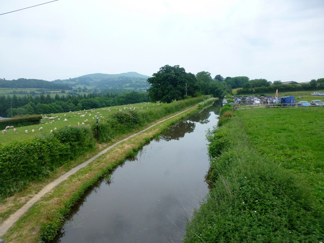
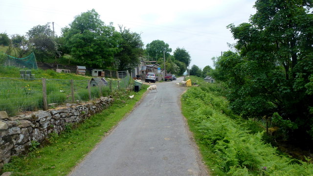
Coedcae-isaf is a small woodland area located in the county of Brecknockshire, Wales. Situated amidst the picturesque landscape of the Brecon Beacons National Park, this woodland is a haven for nature enthusiasts and those seeking tranquility in the great outdoors.

Covering an area of approximately 100 acres, Coedcae-isaf is primarily composed of native broadleaf trees such as oak, beech, and ash. The dense canopy of these trees provides a cool and shaded environment, perfect for a leisurely walk or a picnic on a sunny day. The forest floor is adorned with a rich variety of flora, including bluebells, primroses, and wild garlic, creating a colorful carpet during springtime.

The woodland is home to a diverse range of wildlife, with numerous bird species, such as woodpeckers and song thrushes, inhabiting the trees. Squirrels can also be spotted scurrying among the branches, while badgers and foxes roam the forest floor under the cover of darkness. For those with a keen eye, there are also opportunities to spot lesser-seen creatures, such as bats and hedgehogs.

Coedcae-isaf offers several well-maintained walking paths, allowing visitors to explore the woodland at their own pace. These trails offer breathtaking views of the surrounding countryside, making it an ideal location for photographers and artists. The forest is also intersected by a small stream, adding to its charm and providing a peaceful soundtrack to accompany visitors' walks.

Overall, Coedcae-isaf is a hidden gem within Brecknockshire, offering a serene and enchanting woodland experience for all who venture into its depths.

If you have any feedback on the listing, please let us know in the comments section below.

Coedcae-isaf Images

Images are sourced within 2km of 51.827209/-3.1347193 or Grid Reference SO2114. Thanks to Geograph Open Source API. All images are credited.

Junction on the A465 and rust finished footbridge
Heads of the Valleys road from the new footbridge But which square is the footbridge in? The 1:25000 map shows the grid line through the middle of the bridge, whilst the 1:50000 would suggest that it is at least 100m into this square. To avoid confusion, just a photo of the view eastwards is submitted. The Sugar Loaf above Abergavenny in the distance.
Heads of the Valleys road from the new footbridge
But which square is the footbridge in? The 1:25000 map shows the grid line through the middle of the bridge, whilst the 1:50000 would suggest that it is at least 100m into this square. To avoid confusion, just a photo of the view eastwards is submitted. The Sugar Loaf above Abergavenny in the distance.
Footbridge over the Afon Clydach Rural spot in a wooded valley, but only 200m or so from the traffic on A465.
Footbridge over the Afon Clydach
Rural spot in a wooded valley, but only 200m or so from the traffic on A465.
The Mon & Brecon Canal at Pen-pedair-heol near Llangattock
Ordnance Survey Cut Mark This OS cut mark can be found on the SW parapet of the bridge. It marks a point 140.004m above mean sea level.
Ordnance Survey Cut Mark
This OS cut mark can be found on the SW parapet of the bridge. It marks a point 140.004m above mean sea level.
Improved grassland East of the road across Coedcae Uchaf.
The cone of Y Fal can be seen across the trench of the Usk valley.
Improved grassland
East of the road across Coedcae Uchaf. The cone of Y Fal can be seen across the trench of the Usk valley.
Monmouthshire and Brecon Canal, 1 Looking east towards the marina at Pen-pedair-heol.
Monmouthshire and Brecon Canal, 1
Looking east towards the marina at Pen-pedair-heol.
Monmouthshire and Brecon Canal, 2 Looking west at the bridge near Pen-pedair-heol.
Monmouthshire and Brecon Canal, 2
Looking west at the bridge near Pen-pedair-heol.
View over the Usk valley, 1 Looking north-east towards Y Fal and its long west ridge.
Closer to camera in the adjacent gridsquare to the east is the canal marina at Pen-pedair-heol.
View over the Usk valley, 1
Looking north-east towards Y Fal and its long west ridge. Closer to camera in the adjacent gridsquare to the east is the canal marina at Pen-pedair-heol.
View over the Usk valley, 2 Looking north over Crickhowell with the outline of Crug Hywel and Pen Cerrig-calch beyond.
View over the Usk valley, 2
Looking north over Crickhowell with the outline of Crug Hywel and Pen Cerrig-calch beyond.
Steep hillside above the Usk Cottages and smallholdings on this hillside to the south of Llangattock.
Plus a fine view across the Usk valley to Y Fal.
Steep hillside above the Usk
Cottages and smallholdings on this hillside to the south of Llangattock. Plus a fine view across the Usk valley to Y Fal.
Hillside community Cottages and smallholdings on this hillside to the south of Llangattock.
Hillside community
Cottages and smallholdings on this hillside to the south of Llangattock.
Lane at Pant-y-rhiw Lane contours the steep hillside to the south of Llangattock.
Lane at Pant-y-rhiw
Lane contours the steep hillside to the south of Llangattock.
Hillside above Wern Watkin The bunkhouse at Wern Watkin is somewhere down there.
Across the valley is Y Fal/Sugarloaf.
Hillside above Wern Watkin
The bunkhouse at Wern Watkin is somewhere down there. Across the valley is Y Fal/Sugarloaf.
Road to Waun Watcyn Beyond is the precipitous edge of Mynydd Llangatwg above Waun Watcyn.
Road to Waun Watcyn
Beyond is the precipitous edge of Mynydd Llangatwg above Waun Watcyn.
Woolly residents of Waun Watcyn Common land to the south of Llangattock with a view north across the Usk valley to Y Fal/Sugarloaf.
Woolly residents of Waun Watcyn
Common land to the south of Llangattock with a view north across the Usk valley to Y Fal/Sugarloaf.
Junction at Waun Watcyn Road to the left heads downhill to Crickhowell in the Usk valley.
Junction at Waun Watcyn
Road to the left heads downhill to Crickhowell in the Usk valley.
Road at the base of Darren Disgwylfa The craggy hillside to the right is the eastern edge of Mynydd Llangatwg.
This road leads around the mountain to end up at Brynmawr.
Road at the base of Darren Disgwylfa
The craggy hillside to the right is the eastern edge of Mynydd Llangatwg. This road leads around the mountain to end up at Brynmawr.
Show me another place!

Coedcae-isaf is located at Grid Ref: SO2114 (Lat: 51.827209, Lng: -3.1347193)

Unitary Authority: Monmouthshire

Police Authority: Gwent

What 3 Words

///running.hotspots.bleak. Near Gilwern, Monmouthshire

Nearby Locations

Coedcae-isaf Coedcae Uchaf

Related Wikis

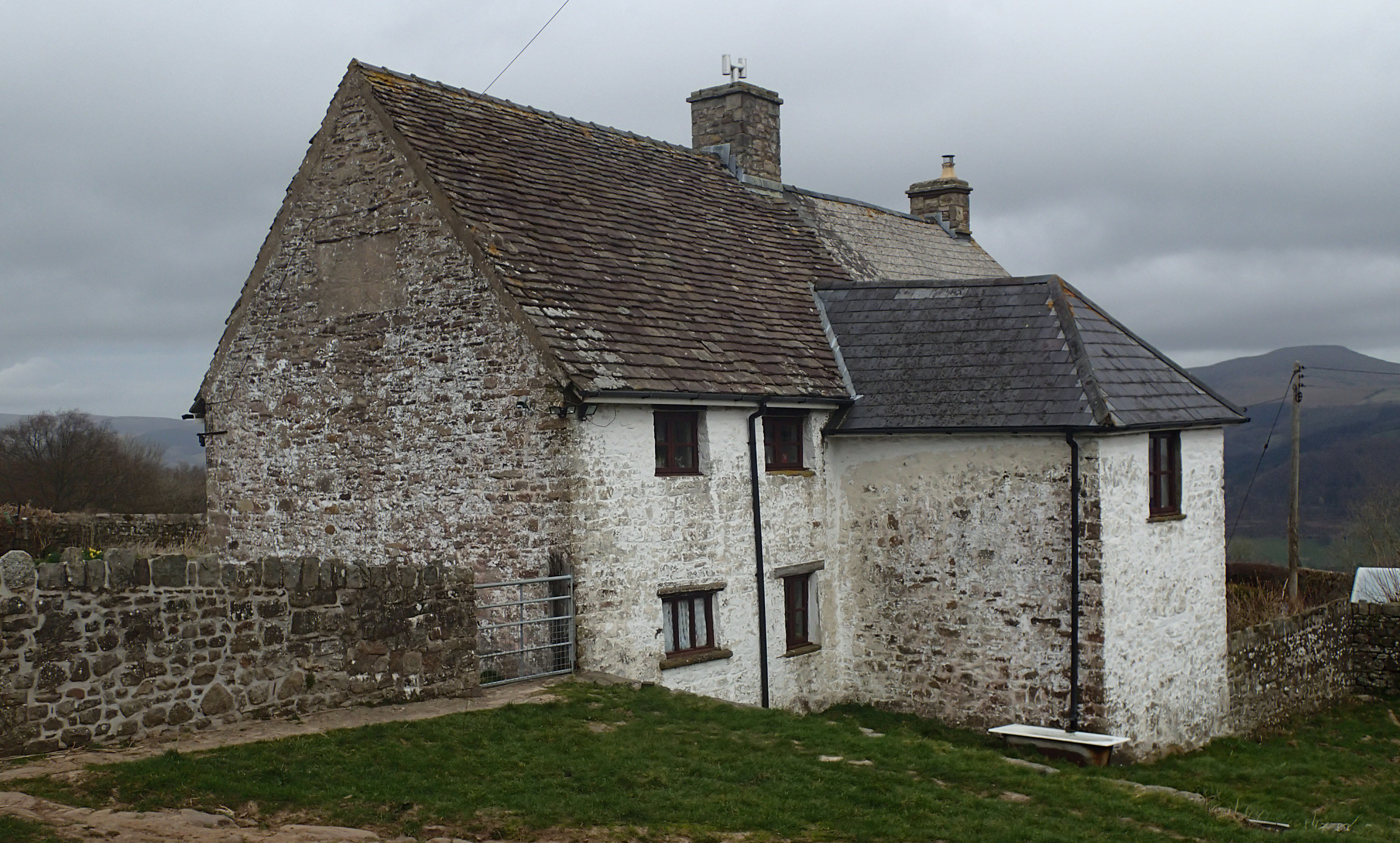
Ty-uchaf Farmhouse, Llanelly

Ty Uchaf Farmhouse, Llanelly, Monmouthshire is a farmhouse in the west of the county dating from the early 17th century. Located 0.5km north-west of the...

Llanelly

Llanelly (Welsh: Llanelli) is the name of a parish and coterminous community in the principal area of Monmouthshire, within the historic boundaries of...

St Elli's Church, Llanelly

The Church of St Elli, Llanelly, Monmouthshire, Wales, is a parish church with its origins in the 14th century. The church underwent three major restorations...

Ogof Agen Allwedd

Ogof Agen Allwedd or Agen Allwedd, is, at 20.2 miles (32.5 km), one of the longest cave systems in Wales, and the longest cave system on the Llangattock...

Nearby Amenities

Located within 500m of 51.827209,-3.1347193
Created By: Merkaartor 0.12
Lat/Long: 51.824369/-3.132164
Barrier: stile
Lat/Long: 51.8308588/-3.1332109
The data included in this document is from www.openstreetmap.org. The data is made available under ODbL.

Have you been to Coedcae-isaf?

Leave your review of Coedcae-isaf below (or comments, questions and feedback).