Alltsigh

Settlement in Inverness-shire

Scotland

Alltsigh

A82 by Loch Ness
A82 by Loch Ness Credit: Jo and Steve Turner

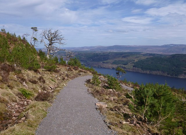
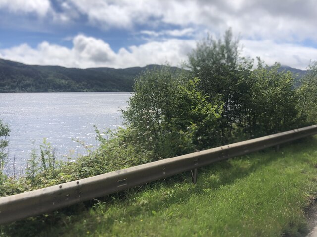
Alltsigh is a small village located in the county of Inverness-shire, Scotland. Situated on the banks of the River Affric, it is nestled within the picturesque Scottish Highlands, offering breathtaking views of the surrounding mountains and lush green landscapes. The village is part of the larger Glen Affric National Nature Reserve, renowned for its diverse wildlife and stunning natural beauty.

With a population of around 100 residents, Alltsigh is a close-knit community that retains its traditional charm. The village is primarily residential, with a scattering of traditional cottages and houses. The main economic activities in the area revolve around agriculture and tourism, with many residents working in local farms or providing services for visitors exploring the nearby hiking trails and nature reserves.

Alltsigh is a popular destination for outdoor enthusiasts, as it serves as a gateway to the Glen Affric area. The region is known for its extensive network of walking paths and trails, making it an ideal location for hiking, cycling, and birdwatching. Additionally, the nearby Loch Beinn a' Mheadhoin offers opportunities for fishing and boating.

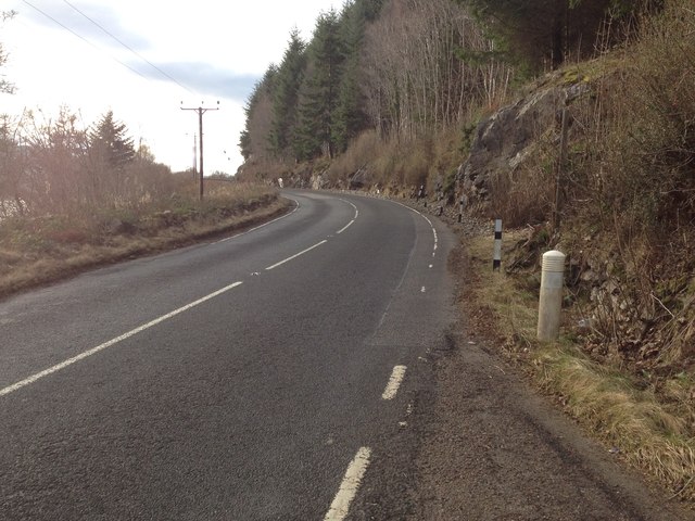
While Alltsigh itself does not have many amenities, the village is within a short driving distance of Cannich, where visitors can find a range of shops, cafes, and a pub. The area is well-connected by road, with the A831 passing through Alltsigh, providing easy access to nearby towns and cities.

Alltsigh is a tranquil and scenic village that offers visitors a chance to immerse themselves in the natural beauty of the Scottish Highlands, making it a must-visit destination for nature lovers and outdoor enthusiasts.

If you have any feedback on the listing, please let us know in the comments section below.

Alltsigh Images

Images are sourced within 2km of 57.236559/-4.558147 or Grid Reference NH4519. Thanks to Geograph Open Source API. All images are credited.

A82 by Loch Ness
A82 by Loch Ness
The beginning of the hairpin bends on the Great Glen Way Just north of Alltsigh
The beginning of the hairpin bends on the Great Glen Way
Just north of Alltsigh
Path descending, in Creag nan Eun Forest This is part of the Great Glen Way high route, it looks like this path has been built fairly recently. The path zigzags as it descends to join a forest track.
Passing a mixture of Scots Pine, including a few old twisted trees, as well as plenty of younger trees. Great views over Loch Ness from here.
Path descending, in Creag nan Eun Forest
This is part of the Great Glen Way high route, it looks like this path has been built fairly recently. The path zigzags as it descends to join a forest track. Passing a mixture of Scots Pine, including a few old twisted trees, as well as plenty of younger trees. Great views over Loch Ness from here.
Track in Creag nan Eun Forest This forest track has been here for a number of years, but it was just a dead end. It is now part of the Great Glen Way high route, linking to a path up the hill.
It looks like this area of forest has been cleared a few years ago, it now has a mixture of heather, bracken and a few old Scots pine trees.
Track in Creag nan Eun Forest
This forest track has been here for a number of years, but it was just a dead end. It is now part of the Great Glen Way high route, linking to a path up the hill. It looks like this area of forest has been cleared a few years ago, it now has a mixture of heather, bracken and a few old Scots pine trees.
Rock stabilisation causes a holdup on the A82
A82 alongside Loch Ness near Alltsigh
Layby overlooking Loch Ness The A82 runs from Glasgow to Fort William and Inverness, passing along the shores of Loch Lomond and Loch Ness and in the shadow of Ben Nevis along the way. The majority of the route is a trunk road and hence managed by Transport Scotland, who view the road as a vitally important link through the Scottish Highlands and beyond. 

At 167 miles, the road is the second longest A-road in Scotland (after the A9) and along its route uses pieces of road first built in the 1750s.
Layby overlooking Loch Ness
The A82 runs from Glasgow to Fort William and Inverness, passing along the shores of Loch Lomond and Loch Ness and in the shadow of Ben Nevis along the way. The majority of the route is a trunk road and hence managed by Transport Scotland, who view the road as a vitally important link through the Scottish Highlands and beyond. At 167 miles, the road is the second longest A-road in Scotland (after the A9) and along its route uses pieces of road first built in the 1750s.
Citylink Bus on Route 919 to Inverness Citylink Volvo B11R with Jonckheere coachwork (K400 SBL) on the A82 at Alltsigh, working route number 919 between Fort William and Inverness
Citylink Bus on Route 919 to Inverness
Citylink Volvo B11R with Jonckheere coachwork (K400 SBL) on the A82 at Alltsigh, working route number 919 between Fort William and Inverness
Southbound A82 near Alltsigh The A82 runs from Glasgow to Fort William and Inverness, passing along the shores of Loch Lomond and Loch Ness and in the shadow of Ben Nevis along the way. The majority of the route is a trunk road and hence managed by Transport Scotland, who view the road as a vitally important link through the Scottish Highlands and beyond. 

At 167 miles, the road is the second longest A-road in Scotland (after the A9) and along its route uses pieces of road first built in the 1750s.
Southbound A82 near Alltsigh
The A82 runs from Glasgow to Fort William and Inverness, passing along the shores of Loch Lomond and Loch Ness and in the shadow of Ben Nevis along the way. The majority of the route is a trunk road and hence managed by Transport Scotland, who view the road as a vitally important link through the Scottish Highlands and beyond. At 167 miles, the road is the second longest A-road in Scotland (after the A9) and along its route uses pieces of road first built in the 1750s.
Forestry road junction near Invermoriston The road to the left drops down to meet the A82.
Forestry road junction near Invermoriston
The road to the left drops down to meet the A82.
Loch Ness from the A82
A82 by Loch Ness
A82 by Loch Ness
A82 by Loch Ness
A82 by Loch Ness
A82 heading south At Loch Ness below Creag nan Eun.
A82 heading south
At Loch Ness below Creag nan Eun.
Loch Ness A view through thick vegetation below Creag nan Eun.
Loch Ness
A view through thick vegetation below Creag nan Eun.
Looking north-east on Loch Ness Below Creag Dhearg.
Looking north-east on Loch Ness
Below Creag Dhearg.
Ros Crana moored off Alltsigh
A82 at Alltsigh
A82 at Alltsigh
Show me another place!

Alltsigh is located at Grid Ref: NH4519 (Lat: 57.236559, Lng: -4.558147)

Unitary Authority: Highland

Police Authority: Highlands and Islands

What 3 Words

///published.blank.magical. Near Drumnadrochit, Highland

Nearby Locations

Alltsigh

Related Wikis

Meall Fuar-mhonaidh

Meall Fuar-mhonaidh is a hill on the west side of Loch Ness, in the Highlands of Scotland. At 699 m in height, it is listed as a Graham and a Marilyn....

River Moriston

The River Moriston (Scottish Gaelic: Abhainn Mhoireastain) is a river in Inverness-shire, Scotland. It flows broadly east-north-east from the outfall of...

Falls of Foyers

The Falls of Foyers (Scottish Gaelic: Eas na Smùide, meaning the smoking falls) are two waterfalls on the River Foyers, which feeds Loch Ness, in Highland...

Achnaconeran

Achnaconeran is a remote crofting settlement in the Inverness committee area of Highland and is in the Scottish council area of Highland. Achnaconeran...

Nearby Amenities

Located within 500m of 57.236559,-4.558147
Bus Stop
Loch Ness Youth Hostel
Bus: yes
Naptan AtcoCode: 670086051
Naptan Bearing: SW
Naptan CommonName: Loch Ness Youth Hostel
Naptan Indicator: at Youth Hostel
Naptan Landmark: Youth Hostel
Naptan NaptanCode: 45327486
Naptan Street: A82
Naptan Verified: no
Public Transport: platform
Source: naptan_import
Lat/Long: 57.236056/-4.5575397
Bus Stop
Loch Ness Youth Hostel
Bus: yes
Direction: N
Naptan AtcoCode: 670086051A
Naptan Bearing: NE
Naptan CommonName: Loch Ness Youth Hostel
Naptan Indicator: opp Youth Hostel
Naptan Landmark: Youth Hostel
Naptan NaptanCode: 45329758
Naptan Street: A82
Naptan Verified: no
Public Transport: platform
Shelter: no
Source: naptan_import
Lat/Long: 57.2361703/-4.5576296
The Lochside Hostel
Addr City: Alltsigh
Addr Postcode: IV63 7YD
Old Name: Loch Ness Youth Hostel
Operator: MacBackpackers
Phone: +44 1320 351274
Tourism: hostel
Website: https://lochsidehostel.com/
Lat/Long: 57.2361107/-4.5573762
Alltsigh
Name Gd: Allt Saigh
Place: hamlet
Lat/Long: 57.2361358/-4.5581178
Barrier: kissing_gate
Lat/Long: 57.2365432/-4.5593066
Material: wood
Power: pole
Lat/Long: 57.2327917/-4.5625773
Material: wood
Power: pole
Lat/Long: 57.2333306/-4.5615686
Material: wood
Power: pole
Lat/Long: 57.2339826/-4.5609095
Material: wood
Power: pole
Lat/Long: 57.2344354/-4.5603969
Material: wood
Power: pole
Lat/Long: 57.2349163/-4.5597551
Material: wood
Power: pole
Lat/Long: 57.2353344/-4.5591458
Power: pole
Lat/Long: 57.2357873/-4.5584451
Power: pole
Lat/Long: 57.2363828/-4.5578597
Material: wood
Power: pole
Lat/Long: 57.2368957/-4.5573896
Material: wood
Power: pole
Lat/Long: 57.2375438/-4.5567578
Material: wood
Power: pole
Lat/Long: 57.238145/-4.5561664
Material: wood
Power: pole
Lat/Long: 57.2387656/-4.5548849
Material: wood
Power: pole
Lat/Long: 57.2392444/-4.5541258
Material: wood
Power: pole
Lat/Long: 57.2396244/-4.5535
The data included in this document is from www.openstreetmap.org. The data is made available under ODbL.

Have you been to Alltsigh?

Leave your review of Alltsigh below (or comments, questions and feedback).