Tyfaenor Park

Wood, Forest in Radnorshire

Wales

Tyfaenor Park

Glyndwr's Way near Tyfaenor Park
Glyndwr's Way near Tyfaenor Park Credit: Dave Kelly

Tyfaenor Park, located in Radnorshire, is a picturesque woodland area renowned for its natural beauty and dense forests. Spread across a sprawling landscape, it covers an approximate area of several hundred hectares. The park is a popular destination for nature enthusiasts, hikers, and those seeking tranquility amidst the serene surroundings.

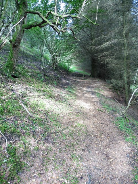
One of the defining features of Tyfaenor Park is its thriving woodlands, which are home to a wide variety of tree species. The dense foliage creates a lush and green canopy, providing a haven for numerous animal and bird species. Visitors can expect to encounter native wildlife such as deer, foxes, squirrels, and a myriad of bird species during their explorations.

A network of well-maintained trails winds through the park, offering visitors the opportunity to immerse themselves in the natural splendor. These paths cater to both casual walkers and more experienced hikers, with varying levels of difficulty available. Along the way, visitors may stumble upon hidden waterfalls, babbling brooks, and enchanting ponds, adding to the park's charm.

Tyfaenor Park also offers recreational activities such as picnicking, camping, and wildlife spotting. The park authorities have set up designated areas for these activities to ensure the preservation of the natural environment. Additionally, there are informative signposts scattered throughout the park, providing educational insights into the local flora and fauna.

Overall, Tyfaenor Park serves as a serene and idyllic retreat for nature enthusiasts, providing an opportunity to reconnect with the natural world and experience the tranquility of Radnorshire's woodlands.

If you have any feedback on the listing, please let us know in the comments section below.

Tyfaenor Park Images

Images are sourced within 2km of 52.334191/-3.3636917 or Grid Reference SO0771. Thanks to Geograph Open Source API. All images are credited.

Glyndwr's Way near Tyfaenor Park
Glyndwr's Way in Neuadd-fach wood
Bridge over Cwm Poeth Brook at Abbeycwmhir This stone bridge allows access to St Mary's churchyard from the nearby hall. The single-span footbridge with its attached walls is grade II-listed (Cadw Building ID: 83092 <span class="nowrap"><a title="http://www.britishlistedbuildings.co.uk/wa-83092-footbridge-attached-walls-and-gateway-on-#.VxPdcP_mqHs" rel="nofollow ugc noopener" href="http://www.britishlistedbuildings.co.uk/wa-83092-footbridge-attached-walls-and-gateway-on-#.VxPdcP_mqHs">Link</a><img style="margin-left:2px;" alt="External link" title="External link - shift click to open in new window" src="https://s1.geograph.org.uk/img/external.png" width="10" height="10"/></span>  British Listed Buildings)
Bridge over Cwm Poeth Brook at Abbeycwmhir
This stone bridge allows access to St Mary's churchyard from the nearby hall. The single-span footbridge with its attached walls is grade II-listed (Cadw Building ID: 83092 LinkExternal link British Listed Buildings)
Parish Church of St Mary, Abbeycwmhir The current church was built in 1856 at the expense of Miss Mary Beatrice Philips, a sister to the Squire George Henry Philips of the adjacent Hall <a title="https://www.geograph.org.uk/photo/1445756" href="https://www.geograph.org.uk/photo/1445756">Link</a>. 
The current building, in Victorian Gothic revival style, replaced that built in 1680 by Sir William Fowler a little to the south, of which no trace remains. The earlier building which was dedicated to St Bridget incorporated carved stonework from the nearby Abbey none of which has been preserved in this church.
Cwm Poeth brook runs through the churchyard and into a culvert under the road, eventually emerging below Home Farm before joining Clywedog Brook. A stone bridge leads over Cwm Poeth from the churchyard to The Hall.

Clwyd Powys Archaeological Trust Radnorshire churches survey <span class="nowrap"><a title="https://cpat.org.uk/Archive/churches/radnor/16703.htm" rel="nofollow ugc noopener" href="https://cpat.org.uk/Archive/churches/radnor/16703.htm">Link</a><img style="margin-left:2px;" alt="External link" title="External link - shift click to open in new window" src="https://s1.geograph.org.uk/img/external.png" width="10" height="10"/></span>
Castles of Wales page <span class="nowrap"><a title="http://www.castlewales.com/cwmhr_ch.html" rel="nofollow ugc noopener" href="http://www.castlewales.com/cwmhr_ch.html">Link</a><img style="margin-left:2px;" alt="External link" title="External link - shift click to open in new window" src="https://s1.geograph.org.uk/img/external.png" width="10" height="10"/></span>

The church, bridge and Abbey ruins are all listed Grade II*.
Parish Church of St Mary, Abbeycwmhir
The current church was built in 1856 at the expense of Miss Mary Beatrice Philips, a sister to the Squire George Henry Philips of the adjacent Hall Link. The current building, in Victorian Gothic revival style, replaced that built in 1680 by Sir William Fowler a little to the south, of which no trace remains. The earlier building which was dedicated to St Bridget incorporated carved stonework from the nearby Abbey none of which has been preserved in this church. Cwm Poeth brook runs through the churchyard and into a culvert under the road, eventually emerging below Home Farm before joining Clywedog Brook. A stone bridge leads over Cwm Poeth from the churchyard to The Hall. Clwyd Powys Archaeological Trust Radnorshire churches survey LinkExternal link Castles of Wales page LinkExternal link The church, bridge and Abbey ruins are all listed Grade II*.
Railings Detail, St Mary's Church, Abbeycwmhir The current church was built in 1856 at the expense of Miss Mary Beatrice Philips, a sister to the Squire George Henry Philips of the adjacent Hall <a title="https://www.geograph.org.uk/photo/1445756" href="https://www.geograph.org.uk/photo/1445756">Link</a>. 
The current building, in Victorian Gothic revival style, replaced that built in 1680 by Sir William Fowler a little to the south, of which no trace remains. The earlier building which was dedicated to St Bridget incorporated carved stonework from the nearby Abbey none of which has been preserved in this church.
Cwm Poeth brook runs through the churchyard and into a culvert under the road, eventually emerging below Home Farm before joining Clywedog Brook. A stone bridge leads over Cwm Poeth from the churchyard to The Hall.

Clwyd Powys Archaeological Trust Radnorshire churches survey <span class="nowrap"><a title="https://cpat.org.uk/Archive/churches/radnor/16703.htm" rel="nofollow ugc noopener" href="https://cpat.org.uk/Archive/churches/radnor/16703.htm">Link</a><img style="margin-left:2px;" alt="External link" title="External link - shift click to open in new window" src="https://s1.geograph.org.uk/img/external.png" width="10" height="10"/></span>
Castles of Wales page <span class="nowrap"><a title="http://www.castlewales.com/cwmhr_ch.html" rel="nofollow ugc noopener" href="http://www.castlewales.com/cwmhr_ch.html">Link</a><img style="margin-left:2px;" alt="External link" title="External link - shift click to open in new window" src="https://s1.geograph.org.uk/img/external.png" width="10" height="10"/></span>

The church, bridge and Abbey ruins are all listed Grade II*.
Railings Detail, St Mary's Church, Abbeycwmhir
The current church was built in 1856 at the expense of Miss Mary Beatrice Philips, a sister to the Squire George Henry Philips of the adjacent Hall Link. The current building, in Victorian Gothic revival style, replaced that built in 1680 by Sir William Fowler a little to the south, of which no trace remains. The earlier building which was dedicated to St Bridget incorporated carved stonework from the nearby Abbey none of which has been preserved in this church. Cwm Poeth brook runs through the churchyard and into a culvert under the road, eventually emerging below Home Farm before joining Clywedog Brook. A stone bridge leads over Cwm Poeth from the churchyard to The Hall. Clwyd Powys Archaeological Trust Radnorshire churches survey LinkExternal link Castles of Wales page LinkExternal link The church, bridge and Abbey ruins are all listed Grade II*.
Abbey-Cwm-Hir Abbeycwmhir (Abaty Cwm Hir, "Abbey in the Long Valley") is a remote village in the valley of the Nant Clywedog. The village is named after Cwmhir Abbey, the Cistercian abbey built there in 1143.
Abbey-Cwm-Hir
Abbeycwmhir (Abaty Cwm Hir, "Abbey in the Long Valley") is a remote village in the valley of the Nant Clywedog. The village is named after Cwmhir Abbey, the Cistercian abbey built there in 1143.
Abbeycwmhir Village Centre Abbeycwmhir (Abaty Cwm Hir, "Abbey in the Long Valley") is a remote village in the valley of the Nant Clywedog. The village is named after Cwmhir Abbey, the Cistercian abbey built there in 1143.
Abbeycwmhir Village Centre
Abbeycwmhir (Abaty Cwm Hir, "Abbey in the Long Valley") is a remote village in the valley of the Nant Clywedog. The village is named after Cwmhir Abbey, the Cistercian abbey built there in 1143.
Abbeycwmhir Telephone Kiosk Abbeycwmhir (Abaty Cwm Hir, "Abbey in the Long Valley") is a remote village in the valley of the Nant Clywedog. The village is named after Cwmhir Abbey, the Cistercian abbey built there in 1143.
Abbeycwmhir Telephone Kiosk
Abbeycwmhir (Abaty Cwm Hir, "Abbey in the Long Valley") is a remote village in the valley of the Nant Clywedog. The village is named after Cwmhir Abbey, the Cistercian abbey built there in 1143.
Cwmhir Abbey (Abaty Cwm Hir) The ruins of Abbey Cwmhir lie in the secluded valley of the Clywedog brook in a remote location typical of those chosen by the Cistercian order. The abbey was built in 1176, probably under the patronage of Cadwallon ap Madog of Maelienydd, as this area of Powys was then called.
The abbey was badly damaged in 1401-2 during the revolt of Owen Glyndwr who believed the English monks to be spies. At the time of dissolution in 1537 there were only three monks here.
Little survives of the abbey buildings and only the nave of the church, the largest in Wales,  still stands. Stone from the abbey was used in the construction of the 17th century church (since demolished) and The Hall.
The nearby mound and boating lake are part of the 19th century landscaping around the adjacent Hall <a title="https://www.geograph.org.uk/photo/1445756" href="https://www.geograph.org.uk/photo/1445756">Link</a>.

Clwyd Powys Archaeological Trust <span class="nowrap"><a title="http://www.cpat.org.uk/projects/longer/abbeyc/abbeyc.htm" rel="nofollow ugc noopener" href="http://www.cpat.org.uk/projects/longer/abbeyc/abbeyc.htm">Link</a><img style="margin-left:2px;" alt="External link" title="External link - shift click to open in new window" src="https://s1.geograph.org.uk/img/external.png" width="10" height="10"/></span>
Castles of Wales page <span class="nowrap"><a title="http://www.castlewales.com/cwmhir.html" rel="nofollow ugc noopener" href="http://www.castlewales.com/cwmhir.html">Link</a><img style="margin-left:2px;" alt="External link" title="External link - shift click to open in new window" src="https://s1.geograph.org.uk/img/external.png" width="10" height="10"/></span>

The abbey ruins are Grade II* listed.
Cwmhir Abbey (Abaty Cwm Hir)
The ruins of Abbey Cwmhir lie in the secluded valley of the Clywedog brook in a remote location typical of those chosen by the Cistercian order. The abbey was built in 1176, probably under the patronage of Cadwallon ap Madog of Maelienydd, as this area of Powys was then called. The abbey was badly damaged in 1401-2 during the revolt of Owen Glyndwr who believed the English monks to be spies. At the time of dissolution in 1537 there were only three monks here. Little survives of the abbey buildings and only the nave of the church, the largest in Wales, still stands. Stone from the abbey was used in the construction of the 17th century church (since demolished) and The Hall. The nearby mound and boating lake are part of the 19th century landscaping around the adjacent Hall Link. Clwyd Powys Archaeological Trust LinkExternal link Castles of Wales page LinkExternal link The abbey ruins are Grade II* listed.
Cistercian Abbey Ruins, Cwmhir Abbey (Abaty Cwm Hir) The ruins of Abbey Cwmhir lie in the secluded valley of the Clywedog brook in a remote location typical of those chosen by the Cistercian order. The abbey was built in 1176, probably under the patronage of Cadwallon ap Madog of Maelienydd, as this area of Powys was then called.
The abbey was badly damaged in 1401-2 during the revolt of Owen Glyndwr who believed the English monks to be spies. At the time of dissolution in 1537 there were only three monks here.
Little survives of the abbey buildings and only the nave of the church, the largest in Wales,  still stands. Stone from the abbey was used in the construction of the 17th century church (since demolished) and The Hall.
The nearby mound and boating lake are part of the 19th century landscaping around the adjacent Hall <a title="https://www.geograph.org.uk/photo/1445756" href="https://www.geograph.org.uk/photo/1445756">Link</a>.

Clwyd Powys Archaeological Trust <span class="nowrap"><a title="http://www.cpat.org.uk/projects/longer/abbeyc/abbeyc.htm" rel="nofollow ugc noopener" href="http://www.cpat.org.uk/projects/longer/abbeyc/abbeyc.htm">Link</a><img style="margin-left:2px;" alt="External link" title="External link - shift click to open in new window" src="https://s1.geograph.org.uk/img/external.png" width="10" height="10"/></span>
Castles of Wales page <span class="nowrap"><a title="http://www.castlewales.com/cwmhir.html" rel="nofollow ugc noopener" href="http://www.castlewales.com/cwmhir.html">Link</a><img style="margin-left:2px;" alt="External link" title="External link - shift click to open in new window" src="https://s1.geograph.org.uk/img/external.png" width="10" height="10"/></span>

The abbey ruins are Grade II* listed.
Cistercian Abbey Ruins, Cwmhir Abbey (Abaty Cwm Hir)
The ruins of Abbey Cwmhir lie in the secluded valley of the Clywedog brook in a remote location typical of those chosen by the Cistercian order. The abbey was built in 1176, probably under the patronage of Cadwallon ap Madog of Maelienydd, as this area of Powys was then called. The abbey was badly damaged in 1401-2 during the revolt of Owen Glyndwr who believed the English monks to be spies. At the time of dissolution in 1537 there were only three monks here. Little survives of the abbey buildings and only the nave of the church, the largest in Wales, still stands. Stone from the abbey was used in the construction of the 17th century church (since demolished) and The Hall. The nearby mound and boating lake are part of the 19th century landscaping around the adjacent Hall Link. Clwyd Powys Archaeological Trust LinkExternal link Castles of Wales page LinkExternal link The abbey ruins are Grade II* listed.
Cwmhir Abbey (Abaty Cwm Hir) Ruins The remains of the Cistercian abbey, viewed from the south-east.
Cwmhir Abbey (Abaty Cwm Hir) Ruins
The remains of the Cistercian abbey, viewed from the south-east.
Lake at Abbey-Cwm-Hir The lake, just to the south of the ruined abbey, was built as part of the 19th century landscaping associated with the nearby hall.
Lake at Abbey-Cwm-Hir
The lake, just to the south of the ruined abbey, was built as part of the 19th century landscaping associated with the nearby hall.
Clywedog Brook at Abbey-Cwm-Hir Water drains from the lake into Clywedog Brook.
Clywedog Brook at Abbey-Cwm-Hir
Water drains from the lake into Clywedog Brook.
Lake and Ruined Abbey, Abbey-Cwm-Hir The ruins of Abbey Cwmhir lie in the secluded valley of the Clywedog brook in a remote location typical of those chosen by the Cistercian order. The abbey was built in 1176, probably under the patronage of Cadwallon ap Madog of Maelienydd, as this area of Powys was then called.
The abbey was badly damaged in 1401-2 during the revolt of Owen Glyndwr who believed the English monks to be spies. At the time of dissolution in 1537 there were only three monks here.
Little survives of the abbey buildings and only the nave of the church, the largest in Wales,  still stands. Stone from the abbey was used in the construction of the 17th century church (since demolished) and The Hall.
The nearby mound and boating lake are part of the 19th century landscaping around the adjacent Hall <a title="https://www.geograph.org.uk/photo/1445756" href="https://www.geograph.org.uk/photo/1445756">Link</a>.

Clwyd Powys Archaeological Trust <span class="nowrap"><a title="http://www.cpat.org.uk/projects/longer/abbeyc/abbeyc.htm" rel="nofollow ugc noopener" href="http://www.cpat.org.uk/projects/longer/abbeyc/abbeyc.htm">Link</a><img style="margin-left:2px;" alt="External link" title="External link - shift click to open in new window" src="https://s1.geograph.org.uk/img/external.png" width="10" height="10"/></span>
Castles of Wales page <span class="nowrap"><a title="http://www.castlewales.com/cwmhir.html" rel="nofollow ugc noopener" href="http://www.castlewales.com/cwmhir.html">Link</a><img style="margin-left:2px;" alt="External link" title="External link - shift click to open in new window" src="https://s1.geograph.org.uk/img/external.png" width="10" height="10"/></span>

The abbey ruins are Grade II* listed.
Lake and Ruined Abbey, Abbey-Cwm-Hir
The ruins of Abbey Cwmhir lie in the secluded valley of the Clywedog brook in a remote location typical of those chosen by the Cistercian order. The abbey was built in 1176, probably under the patronage of Cadwallon ap Madog of Maelienydd, as this area of Powys was then called. The abbey was badly damaged in 1401-2 during the revolt of Owen Glyndwr who believed the English monks to be spies. At the time of dissolution in 1537 there were only three monks here. Little survives of the abbey buildings and only the nave of the church, the largest in Wales, still stands. Stone from the abbey was used in the construction of the 17th century church (since demolished) and The Hall. The nearby mound and boating lake are part of the 19th century landscaping around the adjacent Hall Link. Clwyd Powys Archaeological Trust LinkExternal link Castles of Wales page LinkExternal link The abbey ruins are Grade II* listed.
Abaty Cwm Hir (Cwmhir Abbey) Ruins and Lake The ruins of Abbey Cwmhir lie in the secluded valley of the Clywedog brook in a remote location typical of those chosen by the Cistercian order. The abbey was built in 1176, probably under the patronage of Cadwallon ap Madog of Maelienydd, as this area of Powys was then called.
The abbey was badly damaged in 1401-2 during the revolt of Owen Glyndwr who believed the English monks to be spies. At the time of dissolution in 1537 there were only three monks here.
Little survives of the abbey buildings and only the nave of the church, the largest in Wales,  still stands. Stone from the abbey was used in the construction of the 17th century church (since demolished) and The Hall.
The nearby mound and boating lake are part of the 19th century landscaping around the adjacent Hall <a title="https://www.geograph.org.uk/photo/1445756" href="https://www.geograph.org.uk/photo/1445756">Link</a>.

Clwyd Powys Archaeological Trust <span class="nowrap"><a title="http://www.cpat.org.uk/projects/longer/abbeyc/abbeyc.htm" rel="nofollow ugc noopener" href="http://www.cpat.org.uk/projects/longer/abbeyc/abbeyc.htm">Link</a><img style="margin-left:2px;" alt="External link" title="External link - shift click to open in new window" src="https://s1.geograph.org.uk/img/external.png" width="10" height="10"/></span>
Castles of Wales page <span class="nowrap"><a title="http://www.castlewales.com/cwmhir.html" rel="nofollow ugc noopener" href="http://www.castlewales.com/cwmhir.html">Link</a><img style="margin-left:2px;" alt="External link" title="External link - shift click to open in new window" src="https://s1.geograph.org.uk/img/external.png" width="10" height="10"/></span>

The abbey ruins are Grade II* listed.
Abaty Cwm Hir (Cwmhir Abbey) Ruins and Lake
The ruins of Abbey Cwmhir lie in the secluded valley of the Clywedog brook in a remote location typical of those chosen by the Cistercian order. The abbey was built in 1176, probably under the patronage of Cadwallon ap Madog of Maelienydd, as this area of Powys was then called. The abbey was badly damaged in 1401-2 during the revolt of Owen Glyndwr who believed the English monks to be spies. At the time of dissolution in 1537 there were only three monks here. Little survives of the abbey buildings and only the nave of the church, the largest in Wales, still stands. Stone from the abbey was used in the construction of the 17th century church (since demolished) and The Hall. The nearby mound and boating lake are part of the 19th century landscaping around the adjacent Hall Link. Clwyd Powys Archaeological Trust LinkExternal link Castles of Wales page LinkExternal link The abbey ruins are Grade II* listed.
Dam, Abbeycwmhir Lake Water from the lake overflows here into Cywedog Brook.
Dam, Abbeycwmhir Lake
Water from the lake overflows here into Cywedog Brook.
Abbeycwmhir Lake The lake, just to the south of the ruined abbey, was built as part of the 19th century landscaping associated with the nearby hall.
Abbeycwmhir Lake
The lake, just to the south of the ruined abbey, was built as part of the 19th century landscaping associated with the nearby hall.
Small Waterfall on Clywedog Brook Clywedog Brook, south of the lake at Abbey-Cwm-Hir
Small Waterfall on Clywedog Brook
Clywedog Brook, south of the lake at Abbey-Cwm-Hir
Show me another place!

Tyfaenor Park is located at Grid Ref: SO0771 (Lat: 52.334191, Lng: -3.3636917)

Unitary Authority: Powys

Police Authority: Dyfed Powys

What 3 Words

///flatten.mammal.measuring. Near Penybont, Powys

Related Wikis

Abbeycwmhir

Abbeycwmhir or Abbey Cwmhir (Welsh: Abaty Cwm Hir, "Abbey in the Long Valley") is a village and community in the valley of the Nant Clywedog in Radnorshire...

Cwmhir Abbey

Cwmhir Abbey (Welsh: Abaty Cwm Hir), near Llandrindod Wells in Powys, is a Welsh Cistercian monastery founded in 1176 by Cadwallon ap Madog. A spurious...

Abbey Cwmhir Hall

Abbey-Cwm-Hir Hall is a neo-Elizabethan country house in the Welsh county of Powys. == History == The hall was built in 1833 for Thomas Wilson, a London...

Rhwng Gwy a Hafren

Rhwng Gwy a Hafren (English: Between Wye and Severn) was a region of medieval Wales, located in the Welsh Marches between Powys to the north and Brycheiniog...

Nearby Amenities

Located within 500m of 52.334191,-3.3636917
Building: yes
Lat/Long: 52.3298094/-3.3645875
Building: yes
Lat/Long: 52.3306618/-3.3638365
Direction: SE
Generator Method: photovoltaic
Generator Output Electricity: yes
Generator Solar Modules: 16
Generator Source: solar
Generator Type: solar_photovoltaic_panel
Location: roof
Power: generator
Lat/Long: 52.3306267/-3.3639364
Direction: 175
Generator Method: photovoltaic
Generator Output Electricity: yes
Generator Solar Modules: 16
Generator Source: solar
Generator Type: solar_photovoltaic_panel
Location: roof
Power: generator
Lat/Long: 52.329727/-3.3646022
Direction: 175
Generator Method: photovoltaic
Generator Output Electricity: yes
Generator Solar Modules: 16
Generator Source: solar
Generator Type: solar_photovoltaic_panel
Location: roof
Power: generator
Lat/Long: 52.3297522/-3.3646066
The data included in this document is from www.openstreetmap.org. The data is made available under ODbL.

Have you been to Tyfaenor Park?

Leave your review of Tyfaenor Park below (or comments, questions and feedback).