Coed yr Ynys
Wood, Forest in Flintshire
Wales
Coed yr Ynys

Coed yr Ynys is a picturesque woodland located in Flintshire, Wales. Covering an area of approximately 100 acres, it is a well-preserved forest that offers an idyllic escape for nature enthusiasts and outdoor lovers.
The woodland is predominantly composed of a diverse range of tree species, including oak, beech, birch, and pine. These towering trees create a dense canopy overhead, providing shade and protection for the various flora and fauna that call Coed yr Ynys their home.
Walking through the woodland, visitors are greeted by a tranquil atmosphere and a sense of serenity. The forest floor is covered in a vibrant carpet of moss, ferns, and wildflowers, adding to its natural beauty. There are several well-maintained paths and trails that wind their way through the woods, allowing visitors to explore its hidden corners and discover its hidden treasures.
Coed yr Ynys is not only a haven for nature, but it also holds historical significance. In the heart of the woodland, there is an ancient burial mound dating back to the Bronze Age. This archaeological feature adds a sense of mystery and intrigue to the area, attracting history buffs and archaeology enthusiasts.
The woodland is also home to a variety of wildlife, including squirrels, birds, and small mammals. Birdwatchers will be delighted to spot species such as woodpeckers, nuthatches, and owls among the branches.
Coed yr Ynys is a true gem in Flintshire, offering a peaceful retreat and a chance to reconnect with nature. Whether you are seeking a leisurely stroll, a birdwatching adventure, or a moment of tranquility, this woodland is a must-visit destination.
If you have any feedback on the listing, please let us know in the comments section below.
Coed yr Ynys Images
Images are sourced within 2km of 53.278591/-3.4127876 or Grid Reference SJ0576. Thanks to Geograph Open Source API. All images are credited.


Coed yr Ynys is located at Grid Ref: SJ0576 (Lat: 53.278591, Lng: -3.4127876)
Unitary Authority: Denbighshire
Police Authority: North Wales
What 3 Words
///cunning.surpasses.shackles. Near Cwm, Denbighshire
Nearby Locations
Related Wikis
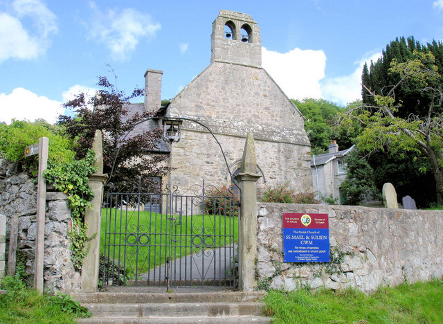
Cwm, Denbighshire
Cwm is a village and community in Denbighshire, below the hill Mynydd y Cwm. The church in Cwm is dedicated to two 6th-century saints, St Mael and St Sulien...
Mynydd y Cwm
Mynydd y Cwm is a hill in the Clwydian Range in Denbighshire, North Wales. It reaches a height of 304.8 metres (1,000 feet). It has recently been promoted...

Moel Hiraddug
Moel Hiraddug, also known as Y Foel, is a hill fort and hill in the Clwydian Range of north-east Wales. The northern part of the hill has been eaten away...
Rhuallt
Rhuallt is a village in Denbighshire, Wales. The village is situated approximately 5 mi (8.0 km) south of Prestatyn and 2 mi (3.2 km) east of St Asaph...
Nearby Amenities
Located within 500m of 53.278591,-3.4127876Have you been to Coed yr Ynys?
Leave your review of Coed yr Ynys below (or comments, questions and feedback).