Allt Cilhywi
Wood, Forest in Brecknockshire
Wales
Allt Cilhywi

Allt Cilhywi is a wood located in the county of Brecknockshire, Wales. It is situated near the village of Cilhywi and covers an area of approximately 100 hectares. The wood is primarily composed of native broadleaf trees such as oak, ash, and beech, creating a diverse and rich ecosystem.
The topography of Allt Cilhywi is hilly, with some areas reaching an elevation of over 200 meters. This provides stunning views of the surrounding countryside and offers visitors a peaceful and tranquil environment to explore and enjoy nature.
The wood is managed by the Forestry Commission, who ensure the conservation and sustainable use of the area. There are well-maintained footpaths and trails throughout the wood, allowing visitors to easily navigate and explore the various habitats and wildlife present.
Allt Cilhywi is home to a wide range of flora and fauna, including many species of birds, mammals, and insects. It provides a vital habitat for a number of rare and protected species, making it an important area for biodiversity conservation.
In addition to its ecological significance, Allt Cilhywi also has historical and cultural importance. There are remnants of ancient settlements and archaeological sites within the wood, providing insight into the human history of the area.
Overall, Allt Cilhywi is a beautiful and diverse woodland that offers both natural and cultural attractions for visitors to enjoy. Whether it's hiking, birdwatching, or simply immersing oneself in the tranquility of nature, this wood has something to offer for everyone.
If you have any feedback on the listing, please let us know in the comments section below.
Allt Cilhywi Images
Images are sourced within 2km of 52.013235/-3.4074009 or Grid Reference SO0335. Thanks to Geograph Open Source API. All images are credited.


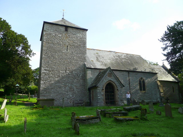
![Church of St Michael [1] The church, in Lower Chapel, was established circa 1790 and rebuilt in 1863. More details are at: <span class="nowrap"><a title="https://cpat.org.uk/Archive/churches/brecon/16385.htm" rel="nofollow ugc noopener" href="https://cpat.org.uk/Archive/churches/brecon/16385.htm">Link</a><img style="margin-left:2px;" alt="External link" title="External link - shift click to open in new window" src="https://s1.geograph.org.uk/img/external.png" width="10" height="10"/></span>](https://s2.geograph.org.uk/geophotos/04/61/15/4611558_13992a4e.jpg)
![Church of St Michael [2] The church, in Lower Chapel, was established circa 1790 and rebuilt in 1863. More details are at: <span class="nowrap"><a title="https://cpat.org.uk/Archive/churches/brecon/16385.htm" rel="nofollow ugc noopener" href="https://cpat.org.uk/Archive/churches/brecon/16385.htm">Link</a><img style="margin-left:2px;" alt="External link" title="External link - shift click to open in new window" src="https://s1.geograph.org.uk/img/external.png" width="10" height="10"/></span>](https://s2.geograph.org.uk/geophotos/04/61/15/4611562_f93b2a1c.jpg)
![Church of St Michael [3] An information notice on the gate of the church.](https://s1.geograph.org.uk/geophotos/04/61/15/4611565_8bedb45e.jpg)
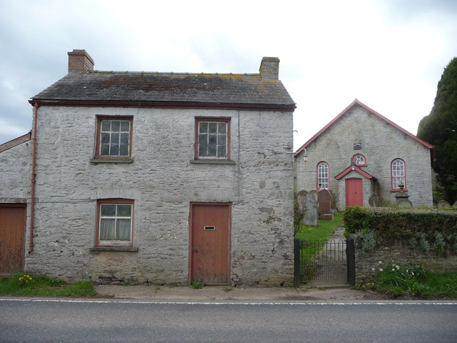
![Lower Chapel [1] This chapel gives the location its name. The English Presbyterian and Calvinistic Methodist chapel was built in 1810, then rebuilt in 1815 and again in 1857. Further rebuilding work took place in 1910.](https://s0.geograph.org.uk/geophotos/04/61/15/4611572_a45de9f8.jpg)
![Lower Chapel [2] A plaque on the side of the chapel.](https://s0.geograph.org.uk/geophotos/04/61/15/4611576_5090bad4.jpg)


Allt Cilhywi is located at Grid Ref: SO0335 (Lat: 52.013235, Lng: -3.4074009)
Unitary Authority: Powys
Police Authority: Dyfed Powys
What 3 Words
///education.warned.unto. Near Brecon, Powys
Nearby Locations
Related Wikis

Castell Madoc
Castell Madoc is a small rural village in Brecon, Powys. The village lies next to Mynydd Epynt, on Afon Honddu, one of the most important tributaries of...

Brecknockshire
Brecknockshire (Welsh: Brycheiniog or Sir Frycheiniog), also known as the County of Brecknock, Breconshire, or the County of Brecon is one of thirteen...

Honddu Isaf
Honddu Isaf is a community in Powys, situated immediately to the north of Brecon on either side of the B4520 road to Builth Wells. It is in the historic...

Pwllgloyw
Pwllgloyw is a settlement on the edge of the Brecon Beacons in the county of Powys in south-east Wales in the community of Honddu Isaf. == Communications... ==
Llandyfaelog Fach
Llandyfaelog Fach (or Llandefaelog Fach), is a small village and community located in Powys, Wales. It includes the surrounding areas of Glan Honddu, Sarnau...
Upper Chapel, Powys
Upper Chapel (Welsh: Capel Uchaf) is a hamlet in the southern part of the county of Powys in mid Wales. It was formerly in the county of Brecknockshire...
Cynog ap Brychan
Cynog son of Brychan (Welsh: Cynog ap Brychan; born c. 434), also known as Saint Cynog or Canog (Old Welsh: Kennauc), was an early Welsh saint and martyr...
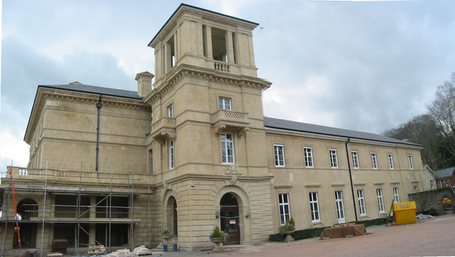
Penoyre House
Penoyre House, Battle, Powys, Wales is a nineteenth century country house. Designed by Anthony Salvin for Colonel John Lloyd Vaughan Watkins, it was built...
Nearby Amenities
Located within 500m of 52.013235,-3.4074009Have you been to Allt Cilhywi?
Leave your review of Allt Cilhywi below (or comments, questions and feedback).