Dol-agored Wood
Wood, Forest in Radnorshire
Wales
Dol-agored Wood
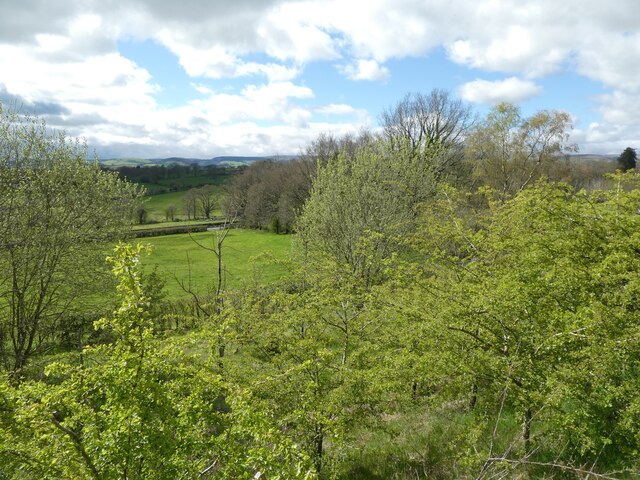
Dol-agored Wood is a picturesque and enchanting forest located in Radnorshire, Wales. Spread over approximately 100 hectares, this woodland is known for its stunning natural beauty and rich biodiversity. The forest is situated in a secluded valley, surrounded by rolling hills and meandering streams, offering a peaceful and serene atmosphere for visitors to enjoy.
The wood is predominantly composed of native deciduous trees, including oak, ash, beech, and birch. These trees create a dense canopy that provides shelter and habitat for a wide variety of flora and fauna. Walking through the forest, visitors can witness an array of vibrant wildflowers, ferns, and mosses that thrive in the damp and shaded environment.
The forest is also home to a diverse range of wildlife. Birdwatchers will be delighted to spot species such as woodpeckers, tawny owls, and red kites soaring above the treetops. The woodland floor is frequented by mammals like badgers, foxes, and voles, while the streams attract otters and kingfishers.
Dol-agored Wood offers a network of well-maintained footpaths, allowing visitors to explore the forest at their own pace. These trails wind through the ancient trees, leading to panoramic viewpoints and tranquil picnic spots. The wood is particularly popular in autumn when the foliage turns a spectacular array of vibrant colors, creating a breathtaking sight.
With its idyllic scenery and abundant wildlife, Dol-agored Wood is a haven for nature lovers and outdoor enthusiasts. Whether it's a leisurely stroll, birdwatching, or simply enjoying the serenity of the natural surroundings, this forest provides a memorable experience for all who visit.
If you have any feedback on the listing, please let us know in the comments section below.
Dol-agored Wood Images
Images are sourced within 2km of 52.187325/-3.4524773 or Grid Reference SO0055. Thanks to Geograph Open Source API. All images are credited.


Dol-agored Wood is located at Grid Ref: SO0055 (Lat: 52.187325, Lng: -3.4524773)
Unitary Authority: Powys
Police Authority: Dyfed Powys
What 3 Words
///prominent.crisps.surfaces. Near Builth Wells, Powys
Nearby Locations
Related Wikis

Cors y Llyn National Nature Reserve
Cors y Llyn National Nature Reserve can be found about 2.5 kilometres south of Newbridge on Wye, off the A470 road in mid-Wales.The bogs and open water...

Builth Road railway station
Builth Road railway station is a station primarily serving the town of Builth Wells, in mid Wales. It is on the Heart of Wales Line. The station is over...
Newbridge-on-Wye
Newbridge-on-Wye (Welsh: Y Bontnewydd-ar-Wy) is a small village in Powys, Wales. It lies, as its name suggests, on the River Wye, just downstream from...
Newbridge on Wye railway station
Newbridge on Wye railway station stood on the single-tracked Mid Wales Railway between Builth Wells and Rhayader. It was closed on 31 December 1962 and...
Nearby Amenities
Located within 500m of 52.187325,-3.4524773Have you been to Dol-agored Wood?
Leave your review of Dol-agored Wood below (or comments, questions and feedback).