Allington

Settlement in Kent Maidstone

England

Allington

Foot crossing on the Medway Valley Walk The Medway Valley Line was built in two stages by the South Eastern Railway. The first stage opened in 1844 was from Paddock Wood following the Medway Valley to Maidstone. In 1856 the line was extended down the Medway Valley to the North Kent Line at Strood (which had opened in 1847). 

This foot crossing is on the latter section and carries the Medway Valley Walk across the line. The next station in this direction is Maidstone Barracks. An old siding to Allington leads off on the right.
Foot crossing on the Medway Valley Walk Credit: Marathon

Allington is a small village located in the county of Kent, in the southeastern region of England. Situated approximately three miles west of Maidstone, the village falls within the civil parish of Allington and is part of the borough of Maidstone.

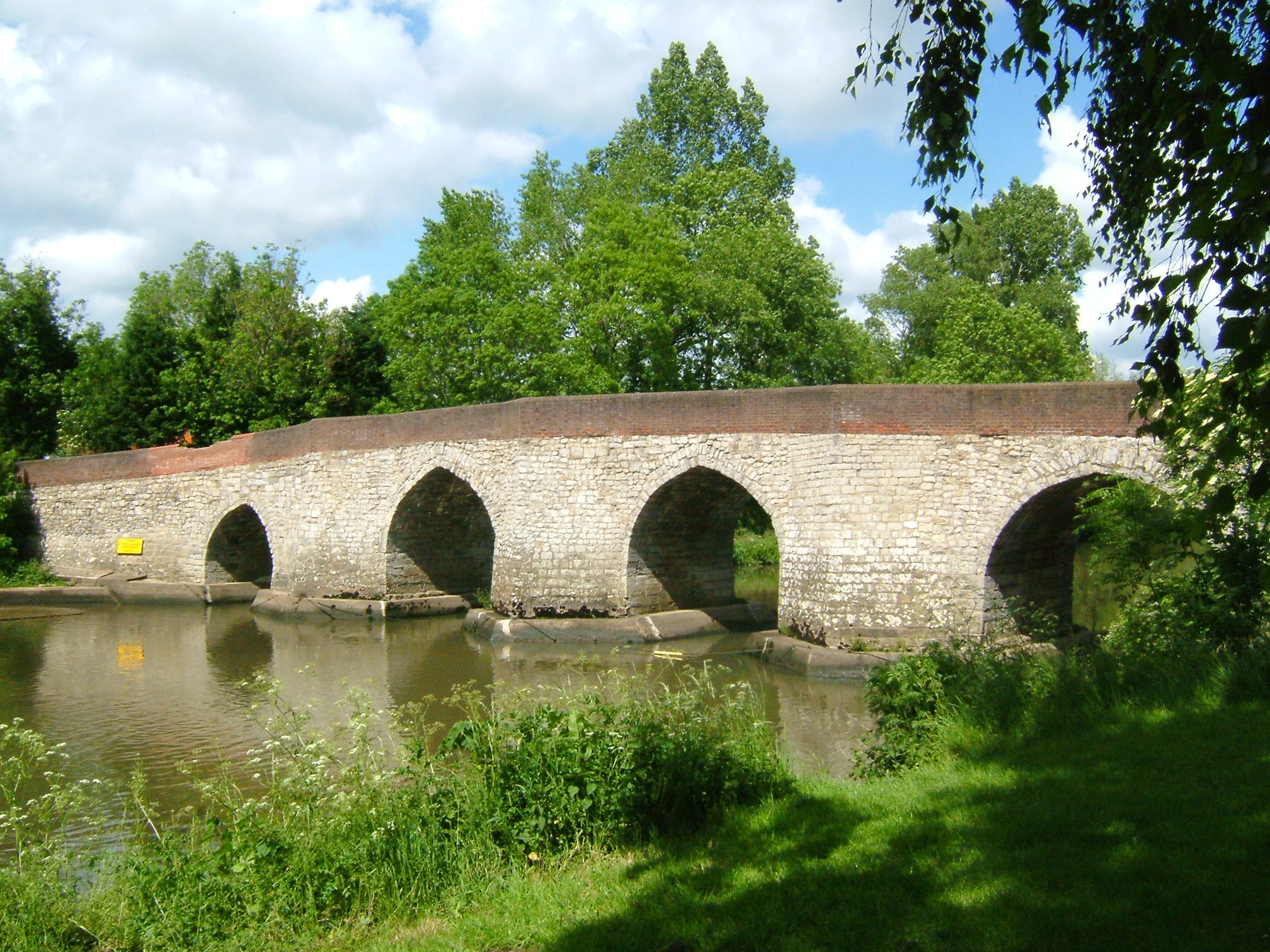
Known for its picturesque setting, Allington is surrounded by lush countryside and is bordered by the River Medway to the north. The village boasts a rich history, with evidence of human settlement dating back to Roman times. The name "Allington" is derived from the Old English words for "the settlement of Ella's people."

Despite its small size, Allington offers a range of amenities and facilities to its residents. The village is home to a primary school, a church, a community center, and a number of local shops and businesses. There are also several public houses in the area, providing social gathering spaces for locals and visitors alike.

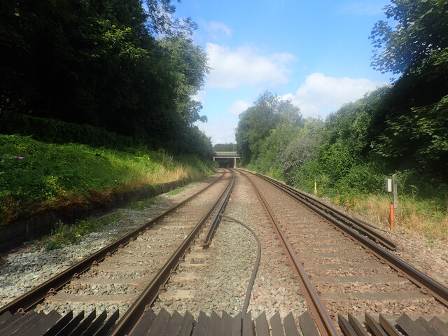
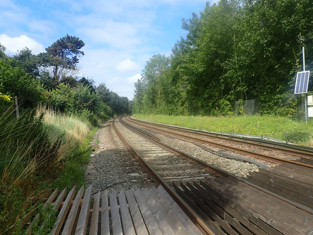
Allington is well-connected to the surrounding area through various transportation links. The village has its own railway station, Allington Halt, which provides regular services to Maidstone and other nearby towns. Additionally, the A20 road passes through Allington, offering convenient road access to Maidstone and the wider Kent region.

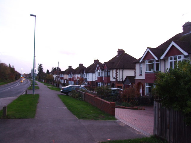
In recent years, Allington has experienced some residential development, with new housing estates being built to accommodate the growing population. Despite this, the village has managed to maintain its rural charm and remains a popular place to live for those seeking a peaceful and scenic environment within close proximity to urban amenities.

If you have any feedback on the listing, please let us know in the comments section below.

Allington Images

Images are sourced within 2km of 51.293043/0.506972 or Grid Reference TQ7457. Thanks to Geograph Open Source API. All images are credited.

Foot crossing on the Medway Valley Walk The Medway Valley Line was built in two stages by the South Eastern Railway. The first stage opened in 1844 was from Paddock Wood following the Medway Valley to Maidstone. In 1856 the line was extended down the Medway Valley to the North Kent Line at Strood (which had opened in 1847). 

This foot crossing is on the latter section and carries the Medway Valley Walk across the line. The next station in this direction is Maidstone Barracks. An old siding to Allington leads off on the right.
Foot crossing on the Medway Valley Walk
The Medway Valley Line was built in two stages by the South Eastern Railway. The first stage opened in 1844 was from Paddock Wood following the Medway Valley to Maidstone. In 1856 the line was extended down the Medway Valley to the North Kent Line at Strood (which had opened in 1847). This foot crossing is on the latter section and carries the Medway Valley Walk across the line. The next station in this direction is Maidstone Barracks. An old siding to Allington leads off on the right.
View from a foot crossing on The Medway Valley Walk The Medway Valley Line was built in two stages by the South Eastern Railway. The first stage opened in 1844 was from Paddock Wood following the Medway Valley to Maidstone. In 1856 the line was extended down the Medway Valley to the North Kent Line at Strood (which had opened in 1847). 

This foot crossing is on the latter section and carries the Medway Valley Walk across the line. The next station in this direction is Aylesford. The bridge just ahead carries the M20 over the line.
View from a foot crossing on The Medway Valley Walk
The Medway Valley Line was built in two stages by the South Eastern Railway. The first stage opened in 1844 was from Paddock Wood following the Medway Valley to Maidstone. In 1856 the line was extended down the Medway Valley to the North Kent Line at Strood (which had opened in 1847). This foot crossing is on the latter section and carries the Medway Valley Walk across the line. The next station in this direction is Aylesford. The bridge just ahead carries the M20 over the line.
Foot crossing on the Medway Valley Walk The Medway Valley Line was built in two stages by the South Eastern Railway. The first stage opened in 1844 was from Paddock Wood following the Medway Valley to Maidstone. In 1856 the line was extended down the Medway Valley to the North Kent Line at Strood (which had opened in 1847). 

This foot crossing is on the latter section and carries the Medway Valley Walk across the line. The next station to the right is Maidstone Barracks and to the left is Aylesford.
Foot crossing on the Medway Valley Walk
The Medway Valley Line was built in two stages by the South Eastern Railway. The first stage opened in 1844 was from Paddock Wood following the Medway Valley to Maidstone. In 1856 the line was extended down the Medway Valley to the North Kent Line at Strood (which had opened in 1847). This foot crossing is on the latter section and carries the Medway Valley Walk across the line. The next station to the right is Maidstone Barracks and to the left is Aylesford.
View from a foot crossing on The Medway Valley Walk The Medway Valley Line was built in two stages by the South Eastern Railway. The first stage opened in 1844 was from Paddock Wood following the Medway Valley to Maidstone. In 1856 the line was extended up the Medway Valley to the North Kent Line at Strood (which had opened in 1847). 

This foot crossing is on the latter section and carries the Medway Valley Walk across the line. The next station in this direction is Aylesford.
View from a foot crossing on The Medway Valley Walk
The Medway Valley Line was built in two stages by the South Eastern Railway. The first stage opened in 1844 was from Paddock Wood following the Medway Valley to Maidstone. In 1856 the line was extended up the Medway Valley to the North Kent Line at Strood (which had opened in 1847). This foot crossing is on the latter section and carries the Medway Valley Walk across the line. The next station in this direction is Aylesford.
Foot crossing on the Medway Valley Walk The Medway Valley Line was built in two stages by the South Eastern Railway. The first stage opened in 1844 was from Paddock Wood following the Medway Valley to Maidstone. In 1856 the line was extended up the Medway Valley to the North Kent Line at Strood (which had opened in 1847). 

This foot crossing is on the latter section and carries the Medway Valley Walk across the line. The next station to the right is Maidstone Barracks and to the left is Aylesford.
Foot crossing on the Medway Valley Walk
The Medway Valley Line was built in two stages by the South Eastern Railway. The first stage opened in 1844 was from Paddock Wood following the Medway Valley to Maidstone. In 1856 the line was extended up the Medway Valley to the North Kent Line at Strood (which had opened in 1847). This foot crossing is on the latter section and carries the Medway Valley Walk across the line. The next station to the right is Maidstone Barracks and to the left is Aylesford.
The Medway Valley Walk The Medway Valley Walk in the centre of Maidstone passes under the railway, just west of Maidstone East station, ahead. The line from Otford to Maidstone East was opened on 1st June 1874 by the London, Chatham & Dover Railway.
The Medway Valley Walk
The Medway Valley Walk in the centre of Maidstone passes under the railway, just west of Maidstone East station, ahead. The line from Otford to Maidstone East was opened on 1st June 1874 by the London, Chatham & Dover Railway.
Elephant on the Medway Valley Walk This is at the end of Lock Lane near Allington Lock. There were 51 of these 'Elmer's sculptures' in the area and they were to be shortly auctioned off to raise money for the Heart of Kent Hospice.
Elephant on the Medway Valley Walk
This is at the end of Lock Lane near Allington Lock. There were 51 of these 'Elmer's sculptures' in the area and they were to be shortly auctioned off to raise money for the Heart of Kent Hospice.
The Medway Valley Walk crosses the M20 The Medway Valley Walk has come up from Allington Lock before crossing the Medway Valley Line and here crosses the M20 Motorway. The North Downs can be seen in the distance.
The Medway Valley Walk crosses the M20
The Medway Valley Walk has come up from Allington Lock before crossing the Medway Valley Line and here crosses the M20 Motorway. The North Downs can be seen in the distance.
London Rd The A20 runs from the London Borough of Lewisham to Dover, Kent. It runs through the major towns of Maidstone, Ashford and Folkestone, terminating at the port of Dover.
London Rd
The A20 runs from the London Borough of Lewisham to Dover, Kent. It runs through the major towns of Maidstone, Ashford and Folkestone, terminating at the port of Dover.
London Road East
London Road East
London Rd The A20 runs from the London Borough of Lewisham to Dover, Kent. It runs through the major towns of Maidstone, Ashford and Folkestone, terminating at the port of Dover.
London Rd
The A20 runs from the London Borough of Lewisham to Dover, Kent. It runs through the major towns of Maidstone, Ashford and Folkestone, terminating at the port of Dover.
Roundabout, A20 The A20 runs from the London Borough of Lewisham to Dover, Kent. It runs through the major towns of Maidstone, Ashford and Folkestone, terminating at the port of Dover.
Roundabout, A20
The A20 runs from the London Borough of Lewisham to Dover, Kent. It runs through the major towns of Maidstone, Ashford and Folkestone, terminating at the port of Dover.
A20 The A20 runs from the London Borough of Lewisham to Dover, Kent. It runs through the major towns of Maidstone, Ashford and Folkestone, terminating at the port of Dover.
A20
The A20 runs from the London Borough of Lewisham to Dover, Kent. It runs through the major towns of Maidstone, Ashford and Folkestone, terminating at the port of Dover.
The Poppy Fields
The Poppy Fields
Roundabout, A20 The A20 runs from the London Borough of Lewisham to Dover, Kent. It runs through the major towns of Maidstone, Ashford and Folkestone, terminating at the port of Dover.
Roundabout, A20
The A20 runs from the London Borough of Lewisham to Dover, Kent. It runs through the major towns of Maidstone, Ashford and Folkestone, terminating at the port of Dover.
The Poppy Fields
The Poppy Fields
Railway bridge, A20 The A20 runs from the London Borough of Lewisham to Dover, Kent. It runs through the major towns of Maidstone, Ashford and Folkestone, terminating at the port of Dover.
Railway bridge, A20
The A20 runs from the London Borough of Lewisham to Dover, Kent. It runs through the major towns of Maidstone, Ashford and Folkestone, terminating at the port of Dover.
Show me another place!

Allington is located at Grid Ref: TQ7457 (Lat: 51.293043, Lng: 0.506972)

Administrative County: Kent

District: Maidstone

Police Authority: Kent

What 3 Words

///being.chopper.gazes. Near Aylesford, Kent

Nearby Locations

Allington Lock Wood

Related Wikis

Medway Valley Walk

The Medway Valley Walk follows the River Medway from Rochester to Tonbridge. Above Allington, it follows the bank of the Medway Navigation. It starts on...

Allington Castle

Allington Castle is a stone castle in Allington, Kent, just north of Maidstone, in England. The first castle on the site was an unauthorised fortification...

Allington, Kent

Allington is an almost entirely modern village situated alongside the sides of the A20 road west of Maidstone in Kent. It is part of the built-up area...

Sandling, Maidstone

Sandling is a hamlet to the north of the town of Maidstone, Kent, England, at the foot of the North Downs. It falls within the parish of Boxley. Notable...

Kent Life

Kent Life (formerly the Museum of Kent Life) is an English open-air museum located at Sandling near Maidstone, next to Allington Locks on the east bank...

Abbey Gate, Kent

Abbey Gate is a hamlet in the borough of Maidstone in Kent, England.

Allington Quarry

Allington Quarry is a 0.8-hectare (2.0-acre) geological Site of Special Scientific Interest north of Maidstone in Kent. It is a Geological Conservation...

Ringlestone (suburb)

Ringlestone is a suburb and housing estate in the town of Maidstone, Kent, England. It is on the eastern side of the River Medway, near Allington, 1.3...

Nearby Amenities

Located within 500m of 51.293043,0.506972
Waterway: weir
Lat/Long: 51.2957345/0.506257
Crossing
Crossing: uncontrolled
Crossing Ref: zebra
Lat/Long: 51.295346/0.5127703
Parking
Lat/Long: 51.2911584/0.505467
Post Box
Ref: ME16 389
Lat/Long: 51.2905251/0.5037125
Post Box
Operator: Royal Mail
Post Box Type: lamp
Ref: ME16 187D
Lat/Long: 51.2922907/0.5062483
Traffic Calming: table
Lat/Long: 51.2890085/0.5047384
Traffic Calming: table
Lat/Long: 51.2898162/0.5035987
Traffic Calming: hump
Lat/Long: 51.2895493/0.5034335
Barrier: bollard
Lat/Long: 51.2901913/0.5030447
Barrier: bollard
Lat/Long: 51.2902949/0.5031944
Bus Stop
Malta Inn
Bus: yes
Naptan AtcoCode: 2400A003690A
Naptan Bearing: NW
Naptan CommonName: Malta Inn
Naptan Indicator: adj
Naptan Landmark: Malta Inn
Naptan NaptanCode: kntagjwd
Naptan PlusbusZoneRef: MSTONEB
Naptan Street: Forstal Road
Naptan Verified: no
Public Transport: platform
Ref: kntagjwd
Source: naptan_import
Source Date: 2018-02-21T10:49:00
Lat/Long: 51.296999/0.5094203
Bus Stop
Malta Inn
Bus: yes
Naptan AtcoCode: 2400A003850A
Naptan Bearing: SE
Naptan CommonName: Malta Inn
Naptan Indicator: opp
Naptan Landmark: The Village
Naptan NaptanCode: kntagmdm
Naptan PlusbusZoneRef: MSTONEB
Naptan Street: Forstal Road
Naptan Verified: no
Public Transport: platform
Ref: kntagmdm
Source: naptan_import
Source Date: 2018-02-21T10:51:00
Lat/Long: 51.2963185/0.5113771
Seamark Type: gate
Waterway: lock_gate
Lat/Long: 51.2955198/0.504803
Traffic Calming: hump
Lat/Long: 51.2900002/0.5031533
Traffic Calming: table
Lat/Long: 51.2896697/0.5042009
Traffic Calming: hump
Lat/Long: 51.2905577/0.5036882
Crossing
Crossing: uncontrolled
Crossing Ref: zebra
Lat/Long: 51.2955791/0.5121725
Crossing
Crossing: uncontrolled
Crossing Ref: zebra
Lat/Long: 51.2956177/0.5119529
Post Box
Operator: Royal Mail
Post Box Type: lamp
Ref: ME14 77
Lat/Long: 51.2965897/0.510081
Kent Life Admissions
Tourism: attraction
Lat/Long: 51.2967985/0.5072215
Seamark Type: gate
Waterway: lock_gate
Lat/Long: 51.2955599/0.5039418
Barrier: cycle_barrier
Material: metal
Note: This may be in slightly the wrong position. Feel free to correct and/or delete this note
Lat/Long: 51.2956706/0.5075195
Seamark Type: gate
Waterway: lock_gate
Lat/Long: 51.2955388/0.5043591
KD Asbestos
Addr City: Maidstone
Addr Housenumber: 10
Addr Postcode: ME16 0LL
Addr Street: St. Laurence Avenue
Phone: +44 800 054 8548
Lat/Long: 51.2914423/0.5017431
KD Pumps
Addr City: Maidstone
Addr Housename: 10
Addr Postcode: ME16 0LL
Addr Street: St. Laurence Avenue
Phone: +44 08000 548 548
Lat/Long: 51.291466/0.5017425
Bus Stop
Kent Life
Flag: no
Naptan AtcoCode: 2400104521
Naptan Bearing: SW
Naptan BusStopType: CUS
Naptan CommonName: Kent Life
Naptan Indicator: o/s
Naptan Landmark: Kent Life
Naptan NaptanCode: kntjpdwp
Naptan Street: Lock Lane
Naptan Verified: no
Public Transport: platform
Ref: kntjpdwp
Source: NAPTAN
Source Date: 2011-07-25T15:58:00
Lat/Long: 51.2965592/0.5077035
Generator Method: photovoltaic
Generator Output Electricity: yes
Generator Source: solar
Generator Type: solar_photovoltaic_panel
Location: roof
Power: generator
Lat/Long: 51.2896743/0.5026057
Generator Method: photovoltaic
Generator Output Electricity: yes
Generator Source: solar
Generator Type: solar_photovoltaic_panel
Location: roof
Power: generator
Lat/Long: 51.2908753/0.5045852
Railway: buffer_stop
Lat/Long: 51.2935825/0.5024877
Generator Method: photovoltaic
Generator Output Electricity: yes
Generator Source: solar
Generator Type: solar_photovoltaic_panel
Location: roof
Power: generator
Lat/Long: 51.293299/0.5141446
Generator Method: photovoltaic
Generator Output Electricity: yes
Generator Source: solar
Generator Type: solar_photovoltaic_panel
Location: roof
Power: generator
Lat/Long: 51.2969268/0.508469
Bicycle Parking
Bicycle Parking: stands
Capacity: 10
Covered: yes
Lat/Long: 51.2964681/0.5070381
Entrance: yes
Lat/Long: 51.2970072/0.5071783
Barrier: bollard
Bollard: fixed
Lat/Long: 51.2970511/0.5082229
The data included in this document is from www.openstreetmap.org. The data is made available under ODbL.

Have you been to Allington?

Leave your review of Allington below (or comments, questions and feedback).