Allt Maes-poeth

Wood, Forest in Brecknockshire

Wales

Allt Maes-poeth

Grazing land near Pentre-Bach
Grazing land near Pentre-Bach Credit: Steven Brown

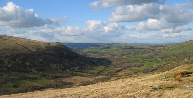
Allt Maes-poeth, located in Brecknockshire, is a picturesque woodland area encompassing a wide variety of flora and fauna. Situated in the heart of the Welsh countryside, this forest is known for its breathtaking natural beauty and its important role in conserving the local ecosystem.

The woodland covers a vast expanse, with tall, majestic trees dominating the landscape. Oak, beech, and ash trees are particularly abundant, providing a dense canopy that creates a cool and tranquil atmosphere. The forest floor is covered in a thick layer of moss and fallen leaves, creating a soft and cushioned pathway for visitors.

Allt Maes-poeth is home to an array of wildlife. Birdwatchers can spot various species, including woodpeckers, owls, and red kites soaring through the sky. Squirrels and rabbits scurry across the forest floor, while deer can often be seen grazing in the meadows on the outskirts of the woodland. The diverse habitats within the forest also support a range of insects, reptiles, and amphibians.

The area is crisscrossed with well-maintained walking trails, allowing visitors to explore the forest at their own pace. These paths lead to hidden gems such as secluded waterfalls and babbling brooks, adding to the enchanting atmosphere of Allt Maes-poeth.

In addition to its natural beauty, the woodland plays an essential role in conservation efforts. The forest is carefully managed to ensure the preservation of its biodiversity, with initiatives in place to protect rare species and promote sustainable forestry practices.

Allt Maes-poeth is a must-visit destination for nature enthusiasts and those seeking tranquility amidst breathtaking scenery. Whether you are a wildlife lover, a keen hiker, or simply looking for a peaceful retreat, this woodland is sure to leave a lasting impression.

If you have any feedback on the listing, please let us know in the comments section below.

Allt Maes-poeth Images

Images are sourced within 2km of 51.96321/-3.5887212 or Grid Reference SN9030. Thanks to Geograph Open Source API. All images are credited.

Grazing land near Pentre-Bach
Ordnance Survey Cut Mark This OS cut mark can be found on the wall NW side of the road. It marks a point 240.396m above mean sea level.
Ordnance Survey Cut Mark
This OS cut mark can be found on the wall NW side of the road. It marks a point 240.396m above mean sea level.
Sheep country Sheep, mainly Kerrys, in a field in the Cilieni valley near Pentre'r-Felin.
Sheep country
Sheep, mainly Kerrys, in a field in the Cilieni valley near Pentre'r-Felin.
Farmland near Pentre'r-Felin Farmland to the east of Pentre'r-Felin.
Farmland near Pentre'r-Felin
Farmland to the east of Pentre'r-Felin.
Country road east of Pentre'r-Felin Country road approaching Pentre'r-Felin from the east.  The forested Yr Allt with its mast can be seen in the background.
Country road east of Pentre'r-Felin
Country road approaching Pentre'r-Felin from the east. The forested Yr Allt with its mast can be seen in the background.
Masspoeth and the Cilieni valley Masspoeth and the Cilieni valley to the north west of Pentre'r-Felin.
Masspoeth and the Cilieni valley
Masspoeth and the Cilieni valley to the north west of Pentre'r-Felin.
Ordnance Survey Cut Mark This OS cut mark can be found on the building SW side of the road. It marks a point 202.479m above mean sea level.
Ordnance Survey Cut Mark
This OS cut mark can be found on the building SW side of the road. It marks a point 202.479m above mean sea level.
The road to Ynys Clydach Looking west along the singletrack no-through-road to Ynys Clydach
The road to Ynys Clydach
Looking west along the singletrack no-through-road to Ynys Clydach
Open Moorland Bridleway on open moorland heading to Cefn Twrch
Open Moorland
Bridleway on open moorland heading to Cefn Twrch
Pentrefelin near Sennybridge View across the bridge towards the church in the next square.
Pentrefelin near Sennybridge
View across the bridge towards the church in the next square.
Penvay  Farm Old Welsh Farm in winter
Penvay Farm
Old Welsh Farm in winter
Pont Pantysgallog Narrow Bridge over the River Usk ( Afon Wysg ) .
Pont Pantysgallog
Narrow Bridge over the River Usk ( Afon Wysg ) .
A40 (snowy) Road Scene Cheverons for sharp bend visible as is a 'P' sign and the layby on the bend which was the road , where the road enters the bend now, was a toll house in the 19th century.
A40 (snowy) Road Scene
Cheverons for sharp bend visible as is a 'P' sign and the layby on the bend which was the road , where the road enters the bend now, was a toll house in the 19th century.
Sunny sheep pasture In the Cilieni valley east of Pentre'r-felin
Sunny sheep pasture
In the Cilieni valley east of Pentre'r-felin
Converted chapel at Pentre'r-felin A tiny community a mile north of Sennybridge.
Converted chapel at Pentre'r-felin
A tiny community a mile north of Sennybridge.
The wooded slopes of Yr Allt This view is of the rear of the hill which dominates the upper Usk valley at Sennybridge.
The wooded slopes of Yr Allt
This view is of the rear of the hill which dominates the upper Usk valley at Sennybridge.
Sheep in the Field Sheep in the field by lane down to Pentre'r-felin
Sheep in the Field
Sheep in the field by lane down to Pentre'r-felin
Looking across the valley to Cefn Gof From the Glynmeddig entrance looking across the valley to Cefn Gof
Looking across the valley to Cefn Gof
From the Glynmeddig entrance looking across the valley to Cefn Gof
Show me another place!

Allt Maes-poeth is located at Grid Ref: SN9030 (Lat: 51.96321, Lng: -3.5887212)

Unitary Authority: Powys

Police Authority: Dyfed Powys

What 3 Words

///dizziness.fancied.grudging. Near Cray, Powys

Nearby Locations

Allt Maes-poeth Cefn Twrch

Related Wikis

Afon Crai

The Afon Crai is a river in Powys, Wales rising in the Fforest Fawr section of the Brecon Beacons National Park and flowing north into the River Usk....

Afon Senni

The Afon Senni is a river in Powys, Wales which rises in the Fforest Fawr section of the Brecon Beacons National Park and flows northwards for 11 kilometres...

Devynock & Sennybridge railway station

Devynock & Sennybridge railway station was a station in Defynnog, Powys, Wales. The station opened in 1867 and closed in 1962. It had a signal box and...

Sennybridge

Sennybridge (Welsh: Pontsenni) is a village in Powys, Wales, in the historic county of Brecknockshire, situated some 42 miles (68 km) from Cardiff and...

Nearby Amenities

Located within 500m of 51.96321,-3.5887212
Place: farm
Lat/Long: 51.963481/-3.5818713
Place: isolated_dwelling
Lat/Long: 51.9644594/-3.5833733
Place: farm
Lat/Long: 51.9665615/-3.5874288
The data included in this document is from www.openstreetmap.org. The data is made available under ODbL.

Have you been to Allt Maes-poeth?

Leave your review of Allt Maes-poeth below (or comments, questions and feedback).