Allt Pen-y-bont

Wood, Forest in Carmarthenshire

Wales

Allt Pen-y-bont

The Afon Brân valley The Afon Brân valley viewed from a no through road below Allt Neuadd-fach.  The Heart of Wales Railway from Swansea to Shrewsbuty passes through this valley.
The Afon Brân valley Credit: Philip Halling

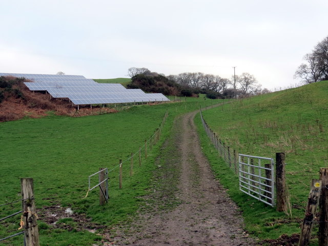
Allt Pen-y-bont is a picturesque wood located in Carmarthenshire, Wales. Situated in the breathtaking countryside, this enchanting forest spans over several acres and offers visitors a tranquil and serene environment to explore.

The wood is characterized by its diverse range of trees, including oak, beech, and ash, which create a beautiful and vibrant canopy overhead. The forest floor is covered in a thick carpet of moss and ferns, adding to the magical atmosphere. Allt Pen-y-bont is particularly renowned for its bluebells, which bloom in abundance during the spring, transforming the forest into a sea of vibrant blue hues.

Several well-marked trails wind their way through the wood, allowing visitors to easily navigate and explore the area. These pathways offer breathtaking views of the surrounding landscape, including rolling hills and flowing streams. The forest is also home to an array of wildlife, such as deer, foxes, and various bird species, making it a popular spot for nature enthusiasts and birdwatchers.

In addition to its natural beauty, Allt Pen-y-bont offers various recreational activities for visitors. There are picnic areas scattered throughout the wood, providing an ideal spot to relax and enjoy a meal amidst nature. The forest is also a popular destination for hiking and cycling, with numerous trails catering to different skill levels.

Overall, Allt Pen-y-bont is a stunning wood in Carmarthenshire that offers an idyllic escape from the hustle and bustle of everyday life. Its natural beauty, diverse flora and fauna, and recreational opportunities make it a must-visit destination for nature lovers and outdoor enthusiasts.

If you have any feedback on the listing, please let us know in the comments section below.

Allt Pen-y-bont Images

Images are sourced within 2km of 52.013292/-3.7846662 or Grid Reference SN7736. Thanks to Geograph Open Source API. All images are credited.

The Afon Brân valley The Afon Brân valley viewed from a no through road below Allt Neuadd-fach.  The Heart of Wales Railway from Swansea to Shrewsbuty passes through this valley.
The Afon Brân valley
The Afon Brân valley viewed from a no through road below Allt Neuadd-fach. The Heart of Wales Railway from Swansea to Shrewsbuty passes through this valley.
Farmland near Abercrychan Mill Farmland in the Afon Brân valley near the entrance to Abercrychan Mill off the A483.
Farmland near Abercrychan Mill
Farmland in the Afon Brân valley near the entrance to Abercrychan Mill off the A483.
Field below Allt Tirisaf Sheep in a field below Allt Tirisaf in the Tywi/Towey valley.
Field below Allt Tirisaf
Sheep in a field below Allt Tirisaf in the Tywi/Towey valley.
Footpath and track Track and footpath leading to Maesllydon Hall.
Footpath and track
Track and footpath leading to Maesllydon Hall.
Field on the edge of Llandovery I photographed this field on the eastern edge of Llandovery because there is planning permission for 61 houses on this land.  Next time I am here it may be under under bricks and mortar.
Field on the edge of Llandovery
I photographed this field on the eastern edge of Llandovery because there is planning permission for 61 houses on this land. Next time I am here it may be under under bricks and mortar.
Field beside the A40, Llandovery I photographed this field on the eastern edge of Llandovery because there is planning permission for 61 houses on this land.  Next time I am here it may be under under bricks and mortar.
Field beside the A40, Llandovery
I photographed this field on the eastern edge of Llandovery because there is planning permission for 61 houses on this land. Next time I am here it may be under under bricks and mortar.
Ordnance Survey 1GL Bolt This OS Bolt can be found on the south facing arch of Pont Dolauhirion. It marks a point 71.0777m above mean sea level.
Ordnance Survey 1GL Bolt
This OS Bolt can be found on the south facing arch of Pont Dolauhirion. It marks a point 71.0777m above mean sea level.
Llwybr Cefn Crug / Cefn Crug Path Llwybr cyhoeddus yn mynd i gyfeiriad Cefn Crug.

A public footpath heading in the direction of Cefn Crug (trans. cairn / mound ridge).
Llwybr Cefn Crug / Cefn Crug Path
Llwybr cyhoeddus yn mynd i gyfeiriad Cefn Crug. A public footpath heading in the direction of Cefn Crug (trans. cairn / mound ridge).
Llwybr Y Grug / Y Grug Path Llwybr cyhoeddus yn mynd i lawr y waered mewn lleoliad a elwir Y Grug.

A public footpath descending at a location known as Y Grug (trans. the cairn / mound).
Llwybr Y Grug / Y Grug Path
Llwybr cyhoeddus yn mynd i lawr y waered mewn lleoliad a elwir Y Grug. A public footpath descending at a location known as Y Grug (trans. the cairn / mound).
Llwybr Cefn Crug / Cefn Crug Path Llwybr cyhoeddus ar Gefn Crug.

Public footpath on Cefn Crug (trans. mound / cairn ridge).
Llwybr Cefn Crug / Cefn Crug Path
Llwybr cyhoeddus ar Gefn Crug. Public footpath on Cefn Crug (trans. mound / cairn ridge).
Allt Cefn Crug Sticil yn rhoi mynediad i Allt Cefn Crug.

A stile giving access to Allt Cefn Crug (trans. mound / cairn ridge wood)
Allt Cefn Crug
Sticil yn rhoi mynediad i Allt Cefn Crug. A stile giving access to Allt Cefn Crug (trans. mound / cairn ridge wood)
Llwybr Allt Cefn Crug / Allt Cefn Crug Path Llwybr cyhoeddus yn gadael Allt Cefn Crug.

A public footpath exiting Allt Cefn Crug (trans. mound / cairn ridge wood).
Llwybr Allt Cefn Crug / Allt Cefn Crug Path
Llwybr cyhoeddus yn gadael Allt Cefn Crug. A public footpath exiting Allt Cefn Crug (trans. mound / cairn ridge wood).
Llwybr ger Ystradwalter / Path near Ystradwalter Llwybr cyhoeddus ger Ffarm Ystradwalter.

Public footpath near Ystradwalter Farm (trans. Walter's vale).
Llwybr ger Ystradwalter / Path near Ystradwalter
Llwybr cyhoeddus ger Ffarm Ystradwalter. Public footpath near Ystradwalter Farm (trans. Walter's vale).
Llwybr Pont Rhyd Owen / Pont Rhyd Owen Path Llwybr cyhoeddus yn cyrraedd yr A483 wrth Bont Rhyd Owen.

A public footpath arriving at the A483 at Pont Rhyd Owen (trans. Owen's ford bridge).
Llwybr Pont Rhyd Owen / Pont Rhyd Owen Path
Llwybr cyhoeddus yn cyrraedd yr A483 wrth Bont Rhyd Owen. A public footpath arriving at the A483 at Pont Rhyd Owen (trans. Owen's ford bridge).
Llwybr Neuadd Maesllydan / Maesllydan Hall Path Llwybr cyhoeddus yn mynd i gyfeiriad Neuadd Maesllydan.

A public footpath heading in the direction of Maesllydan Hall (trans. wide field).
Llwybr Neuadd Maesllydan / Maesllydan Hall Path
Llwybr cyhoeddus yn mynd i gyfeiriad Neuadd Maesllydan. A public footpath heading in the direction of Maesllydan Hall (trans. wide field).
Sticil ger Danyrallt / Stile near Danyrallt Llwybr cyhoeddus ger Ffarm Danyrallt.

A public footpath near Danyrallt Farm (trans. below the wood).
Sticil ger Danyrallt / Stile near Danyrallt
Llwybr cyhoeddus ger Ffarm Danyrallt. A public footpath near Danyrallt Farm (trans. below the wood).
Pont Maesllydan / Maesllydan Bridge Pont yn rhychwantu Afon Bran ger Neuadd Maesllydan.

A bridge spanning Afon Bran near Maesllydan Hall (trans. wide field).
Pont Maesllydan / Maesllydan Bridge
Pont yn rhychwantu Afon Bran ger Neuadd Maesllydan. A bridge spanning Afon Bran near Maesllydan Hall (trans. wide field).
Tuag at yr A483 / Towards the A483 Llwybr cyhoeddus yn mynd i gyfeiriad yr A483.

A public footpath heading in the direction of the A483.
Tuag at yr A483 / Towards the A483
Llwybr cyhoeddus yn mynd i gyfeiriad yr A483. A public footpath heading in the direction of the A483.
Show me another place!

Allt Pen-y-bont is located at Grid Ref: SN7736 (Lat: 52.013292, Lng: -3.7846662)

Unitary Authority: Carmarthenshire

Police Authority: Dyfed Powys

What 3 Words

///turkey.donation.sedative. Near Llandovery, Carmarthenshire

Related Wikis

Dolauhirion Bridge

Dolauhirion Bridge (Welsh: Pont Dolauhirion) is a single arch stone bridge which carries road traffic from Llandovery to Cilycwm over the River Towy (Welsh...

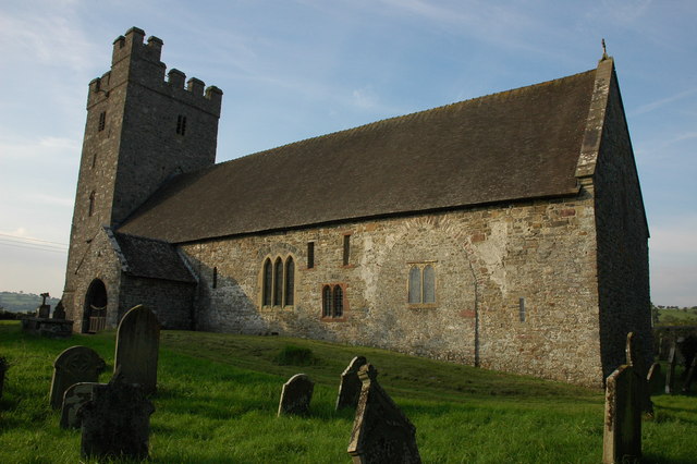
St Mary's Church, Llanfair-ar-y-bryn

St Mary's Church is a Church in Wales place of worship near Llandovery, Carmarthenshire, Wales. It was formerly the parish church of Llanfair-ar-y-bryn...

Alabum

The rectangular enclosure that defined this Roman fort was built in the 70s AD as part of the campaign to integrate southern Wales into the Roman province...

Abercrychan

Abercrychan is a small village in the north-east of Carmarthenshire. It is located on the A483, 4 miles to the north of the town of Llandovery. The village...

Llandovery Hospital

Llandovery Hospital (Welsh: Ysbyty Llanymddyfri) is a community hospital in Llandovery, Wales. It is managed by the Hywel Dda University Health Board....

Ebenezer Baptist Chapel, Llandovery

Ebenezer Baptist Chapel is a place of worship in the town of Llandovery, Carmarthenshire, Wales. The building was constructed in 1844 and is located at...

Llandovery

Llandovery (; Welsh: Llanymddyfri [ɬanəmˈðəvrɪ]) is a market town and community in Carmarthenshire, Wales. It lies on the River Tywi and at the junction...

Salem Independent Chapel, Llandovery

Salem Independent Chapel is an Independent chapel in the town of Llandovery, Carmarthenshire, Wales. The present building dates from between 1829 and 1830...

Nearby Amenities

Located within 500m of 52.013292,-3.7846662
Place: farm
Lat/Long: 52.0122582/-3.7785643
Power: pole
Lat/Long: 52.016298/-3.7880409
Power: pole
Lat/Long: 52.0154759/-3.7893042
Power: pole
Transformer: distribution
Lat/Long: 52.014738/-3.7903368
Power: pole
Lat/Long: 52.0144574/-3.7914392
Power: pole
Lat/Long: 52.0175492/-3.7861311
Power: pole
Lat/Long: 52.0169088/-3.7871826
The data included in this document is from www.openstreetmap.org. The data is made available under ODbL.

Have you been to Allt Pen-y-bont?

Leave your review of Allt Pen-y-bont below (or comments, questions and feedback).