Allt Nant Ioroth

Wood, Forest in Carmarthenshire

Wales

Allt Nant Ioroth

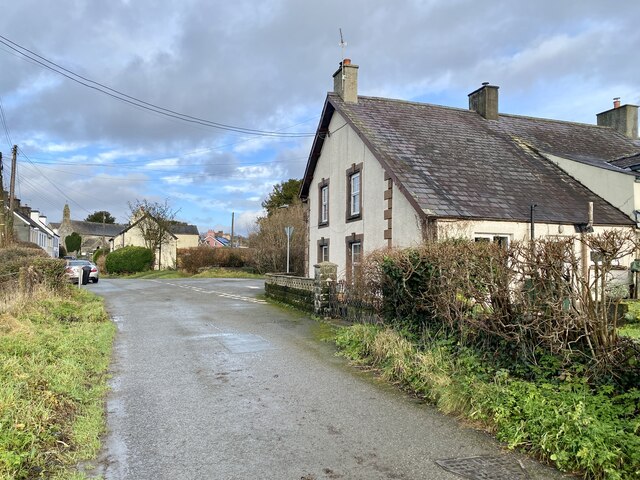
Heol ger Llwynmeredydd / A road near Llwynmeredydd Heol fach ger Ffarm Llwynmeredydd.

A minor road near Llwynmeredydd Farm (trans. Meredydd's grove).
Heol ger Llwynmeredydd / A road near Llwynmeredydd Credit: Alan Richards

Allt Nant Ioroth is a picturesque wooded area located in Carmarthenshire, Wales. Situated in the western part of the county, this enchanting forest covers an area of approximately 200 acres. It is nestled in the heart of the Towy Valley, surrounded by rolling hills and meandering rivers.

The forest is predominantly composed of native broadleaf trees, such as oak, beech, and ash. These majestic trees create a dense canopy, providing a haven for a variety of wildlife. Visitors to Allt Nant Ioroth may have the opportunity to spot an array of bird species, including woodpeckers, owls, and warblers. Small mammals like foxes, badgers, and squirrels also call this woodland home.

Tranquility and natural beauty are the defining characteristics of Allt Nant Ioroth. The forest offers a network of walking trails, allowing visitors to explore its serene surroundings. The paths wind through the trees, revealing breathtaking vistas of the valley and the distant mountains. The air is filled with the soothing sounds of rustling leaves and birdsong, making it an ideal destination for nature lovers and hikers seeking a peaceful retreat.

Allt Nant Ioroth is also steeped in history. Ruins of an old watermill can be found within the forest, a reminder of its past industrial significance. The site is now protected as a nature reserve, ensuring the preservation of its natural and cultural heritage.

In conclusion, Allt Nant Ioroth is a captivating woodland retreat in Carmarthenshire, offering a haven of tranquility and natural beauty. Its rich biodiversity and scenic trails make it a popular destination for those seeking solace in nature.

If you have any feedback on the listing, please let us know in the comments section below.

Allt Nant Ioroth Images

Images are sourced within 2km of 51.947141/-3.7904776 or Grid Reference SN7729. Thanks to Geograph Open Source API. All images are credited.

Heol ger Llwynmeredydd / A road near Llwynmeredydd Heol fach ger Ffarm Llwynmeredydd.

A minor road near Llwynmeredydd Farm (trans. Meredydd's grove).
Heol ger Llwynmeredydd / A road near Llwynmeredydd
Heol fach ger Ffarm Llwynmeredydd. A minor road near Llwynmeredydd Farm (trans. Meredydd's grove).
Heol Fach ger Rhyblid /  Minor road near Rhyblid Heol fach wledig ger Ffarm Rhyblid. Mae'r trac ar y chwith yn heol goll. 

A minor rural road near Rhyblid Farm. The track on the left is a lost road.
Heol Fach ger Rhyblid / Minor road near Rhyblid
Heol fach wledig ger Ffarm Rhyblid. Mae'r trac ar y chwith yn heol goll. A minor rural road near Rhyblid Farm. The track on the left is a lost road.
Pen Caenewydd Cairn Bronze Age Cairn 9m in diameter and 0.3m high.
Pen Caenewydd Cairn
Bronze Age Cairn 9m in diameter and 0.3m high.
Ordnance Survey Cut Mark This OS cut mark can be found on the barn conversion at Gilfach Farm. It marks a point 203.411m above mean sea level.
Ordnance Survey Cut Mark
This OS cut mark can be found on the barn conversion at Gilfach Farm. It marks a point 203.411m above mean sea level.
Y Gaer, Castell Waunberllan A moated site near Myddfai.  Post Medieval. 

<span class="nowrap"><a title="https://coflein.gov.uk/en/site/304633?term=Myddfai&pg=3" rel="nofollow ugc noopener" href="https://coflein.gov.uk/en/site/304633?term=Myddfai&pg=3">Link</a><img style="margin-left:2px;" alt="External link" title="External link - shift click to open in new window" src="https://s1.geograph.org.uk/img/external.png" width="10" height="10"/></span>
Y Gaer, Castell Waunberllan
A moated site near Myddfai. Post Medieval. LinkExternal link
Approaching Myddfai
Approaching Myddfai
Entrance to Llwynrhicet
Birthplace of John Thomas, hymn writer “Am fod fy Iesu’n fyw
Byw hefyd fydd ei Saint …”
Birthplace of John Thomas, hymn writer
“Am fod fy Iesu’n fyw Byw hefyd fydd ei Saint …”
Gelli Mydog
Gelli Mydog
Track leading to Tirpaun
Pwll Calch farm
Pwll Calch farm
Gilfach Farm
Gilfach Farm
Footbridge over Nant yr Hiddl This footbridge is great to look at but I would suggest that walking through the ford is a safer option.
Footbridge over Nant yr Hiddl
This footbridge is great to look at but I would suggest that walking through the ford is a safer option.
Footpath towards the Nant yr Hiddl Taken in October this shows the track from the tar road to the ford- Most of the track is on bare rock and steep in parts, slippery when wet!
Footpath towards the Nant yr Hiddl
Taken in October this shows the track from the tar road to the ford- Most of the track is on bare rock and steep in parts, slippery when wet!
Track to Gelli-felen Track to Gelli-felen South West of Myddfei
Track to Gelli-felen
Track to Gelli-felen South West of Myddfei
Lane by Llwynrhicet Lane by Llwynrhicet heading to Myddfei
Lane by Llwynrhicet
Lane by Llwynrhicet heading to Myddfei
Bridge over Afon Bran Bridge over Afon Bran South East of Myddfai
Bridge over Afon Bran
Bridge over Afon Bran South East of Myddfai
Track up to Esgair-llaethdy Track up to Esgair-llaethdy South east of Myddfai
Track up to Esgair-llaethdy
Track up to Esgair-llaethdy South east of Myddfai
Show me another place!

Allt Nant Ioroth is located at Grid Ref: SN7729 (Lat: 51.947141, Lng: -3.7904776)

Unitary Authority: Carmarthenshire

Police Authority: Dyfed Powys

What 3 Words

///pianists.hormones.retrial. Near Llanddeusant, Carmarthenshire

Related Wikis

St Michael's Church, Myddfai

St Michael's Church is the Anglican parish church for the parish of Myddfai, south of Llandovery, in Carmarthenshire, Wales. The present building dates...

Myddfai

Myddfai () is a small village and community in Carmarthenshire, Wales. It is situated south of Llandovery in the Brecon Beacons, and has a population...

Llwynywermod

Llwynywermod (Welsh: Llwynywermwd; Welsh pronunciation: [ɬʊi̯n.ə.wɛr.mʊd]), also known as Llwynywormwood, is an estate owned by the Duchy of Cornwall,...

Mandinam a Coed Deri

Mandinam a Coed Deri is an area of woodland and pasture that is a Site of Special Scientific Interest in Carmarthen & Dinefwr, Wales. == See also == List...

Nearby Amenities

Located within 500m of 51.947141,-3.7904776
Direction: 215
Generator Method: photovoltaic
Generator Output Electricity: yes
Generator Solar Modules: 17
Generator Source: solar
Generator Type: solar_photovoltaic_panel
Location: roof
Power: generator
Lat/Long: 51.9493419/-3.793175
The data included in this document is from www.openstreetmap.org. The data is made available under ODbL.

Have you been to Allt Nant Ioroth?

Leave your review of Allt Nant Ioroth below (or comments, questions and feedback).